Showing 2890 items matching " settlers"
-
 Phillip Island and District Historical Society Inc.
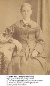
Photographs, Flora Miller & Catherine Walker (nee Miller), approx 1880's
The Millers & Walkers Phillip IslandTwo Photographs on backing sheet. 403-01: Flora Miller 403-02: Catherine Walker and family403-01: "Flora Miller (nee McInnis) Wife of Robert Miller, early settler. In 1868 Robert Miller selected block No. 21 Watts Road, Ventnor, next to Quoin Hill and the family lived there. 403-02: "Catherine Walker (nee Kitty Miller) Photographed with three of her children around 1888. (The identity of the man and the youngest child in this photograph are unknown. Records show that Catherine's husband, James Walker, died in 1885. Her youngest child was her daughter, Flora, on left in the photo).flora miller (nee mcinnis), catherine walker (nee kitty miller), james walker, robert miller, lynette carr -
 Warrnambool and District Historical Society Inc.
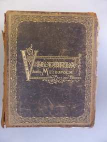
Book, Victoria & Its Metropolis Vol 1 & 2, 1888
These two volumes are seminal historical writings published in 1888. The author of Volume One is Alexander Sutherland (1852-1902), described as ‘a forgotten Australian intellectual’. Born in Scotland, Sutherland was a teacher, poet, biographer, novelist, scientist, philosopher and journalist. In 1902 he was the Registrar of Melbourne University and he was the Secretary of the Royal Society of Victoria. With his brother, George, he wrote a history of Australia and New Zealand which sold 100,000 copies, the first best-selling Australian history. His book, ‘The Origin and Growth of the Moral Instinct’ influenced Russian philosophical thought. This is a most significant book as it contains short biographical notes on a great number of early (19th century) residents of the Warrnambool district. As well as listing information on Warrnambool identities it includes information on residents of Purnim, Wangoom, Dennington, Panmure, Garvoc, Framlingham, Winslow, Yangery, Woodford, Mailors Flat, Grasmere, Bushfield and Allansford. It is a great resource for researchers today. The two volumes also contain illustrations pertaining to the areas around Warrnambool and are of great historical as well as artistic interest. These are two volumes of ‘Victoria and Its Metropolis’. They are leather bound with a black cover, heavily ornamented in gold around the edges of the cover and with the printed material also in gold lettering in an ornamental pattern. The spine of the covers are brown with gold ornamental patterns and printing. Volume One has 594 pages with 258 illustrations , all black and white and this volume contains writings on the early days of the colony up to 1888 and chapters on the arts, churches, education, industries, science etc. in Victoria. Volume Two has 822 pages with many black and white illustrations and chapters on the regions in Victoria and biographical notes on the pioneer settlers of these districts. Both volumes are in a very tattered condition with many loose pages and the leather binding much torn and with some parts missing. Volume One cover: ‘Victoria and its Metropolis, Past and Present’ Volume One spine: ‘Victoria and its Metropolis, Vol. 1’ Volume Two Cover: ‘Victoria and its Metropolis, Past and Present’’ Volume Two Spine: ‘Victoria and its Metropolis, Vol. 2’ 19th century victorian history, victorian pioneer settlers, alexander sutherland -
 Phillip Island and District Historical Society Inc.
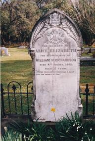
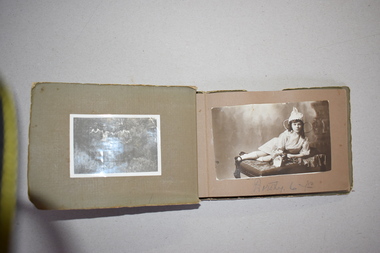
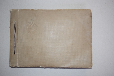
Photograph Album, Kodak, Phillip Island Cemetery, c 1990
The Album was compiled by Nancy McHaffie late 1990's, with the assistance of Edith Jeffery's, with her book "Garden of Memories" and extensive knowledge of Phillip Island. The Cemetery lies back from the road and is surrounded by Manna Gums, rare Peppermint Gums, Blackwoods and other native trees. In all 25 acres of land were set aside as Crown Land in the land settlement of 1868. There are 6.2 acres of wetlands near the cemetery entrance.466-25: William and Alice Richardson: Alice Barnard married William Richardson at Hawthorn, April 1887. Alice's father Fredrick was a Model Maker employed at the Melbourne Museum. Alice died in childbirth having her third child, Joseph in 1892. Baby Joseph died in April 1893, eight months later at Rhyll. 466-26: The Forrest Family: The Forrest family were amongst our early settlers. The Forrest Caves are named after them. Matthew Forrest arrived by dray from Tarradale on 9th November 1869. He died in 1916 at the age of 75. His Grandson, Peter Forrest Sr. has recorded that Matthew was the first to plant Marum Grass on the Island to prevent erosion.phillip island cemetery, nancy mchaffie, edith jeffery -
 Kew Historical Society Inc
Archive (Sub-series) - Subject File, Kew Historical Society, DUMARESQ Family, 1958
Various partiesReference, Research, InformationSecondary Values (KHS Imposed Order)Subject file containing information on the Dumaresq family of Kew who were early settlers in Kew and in Tasmania. In Kew, the Dumaresqs built their house St Helliers (1888-), about which Margaret Dumaresq a member of the Society wrote a profile in 1959. In the file there are a number of newspaper articles/clippings including one noting the death of Miss Dumaresq who had been a Vice-President. In 1971, Miss Dumaresq presented a long talk on her family’s history, which was recorded and is now transcribed. Her discussion of her family’s past dates back to the Battle of Waterloo. What appear to be her handwritten notes are kept in the file. The file contains an album of 16 postcards of places and people at Melbourne University donated by FKM Dumaresq.dumaresq family - kew (vic), margaret dumaresq, fkm dumaresq, frances dumaresq, capt. edward dumaresq, edward alfred dumaresq, st helliers - kew (vic), postcards - melbourne universitydumaresq family - kew (vic), margaret dumaresq, fkm dumaresq, frances dumaresq, capt. edward dumaresq, edward alfred dumaresq, st helliers - kew (vic), postcards - melbourne university -
 Orbost & District Historical Society
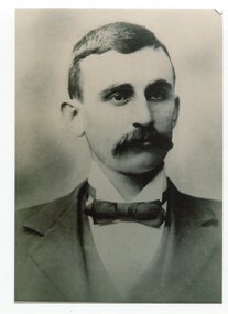
black and white photograph, C1936
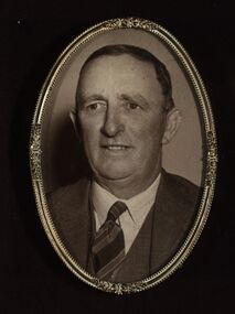
This is a photograph of Councillor Hamilton Rutherford Reed who represented North Riding 1918 - 1936. Hamilton Reed was an early settler at Goongerah. In 1868 Hamilton Reed and John Locke both of Bendoc secured a grazing area of 60,000 acres at Goongerah. About the year 1878 Hamilton Reed and C. W. Nicholson decided to, if possible, to go from Bendoc to Orbost via Goongerah, they accomplished the task in 4 days from Goongerah. (more info. Newsletter September 2004)This item is associated with the Orbost Shire Council. The shire covered an area of 9,347 square kilometres and existed from 1892 until 1994 when it became part of the East Gippsland Shire Council.A black / white head and shoulders portrait photograph of a moustached man in a suit. There is also a framed photograph.on back - "Cr H.R. Reed, North Riding 1918-1936"reed-hamilton-rutherford goongerah-history orbost-shire-council -
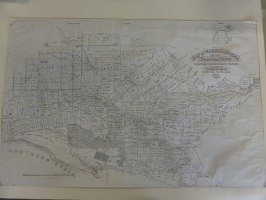 Warrnambool and District Historical Society Inc.
Map, Warrnambool 1859, Late 20th century (copy)
This is a copy of Bromfield’s 1856 map of Warrnambool and district. James Astley Bromfield was a pioneer settler in Warrnambool. He established a chemist’s shop in 1854, initially situated in Timor Street. He moved his shop to Liebig Street with a new building erected in 1875. Bromfield was a prominent resident of Warrnambool (Shire Councillor, Fire Brigade member, Cricket Club member, associated with horse racing etc). He was interested in preserving the history of Warrnambool and this map he produced in 1856 was an example of this interest.This is a copy only but this 1856 map is of prime importance as it contains the names of the original landowners of land in north Warrnambool and the surrounding district. It is a frequently-used resource by historians.This is a copy of a map of Warrnambool and its agricultural district published by James Astley Bromfield in 1856. The map is mounted on cardboard and has black printing on a white background. ‘Map of Warrnambool and its Agricultural District according to the Government Survey’s published by Astley Bromfield, Medical Hall, Warrnambool 1856, James Ferguson, Lithr., Melbne.’bromfield’s 1856, map, warrnambool and district -
Warrnambool and District Historical Society Inc.
Administrative record - Customer cash book, Swinton and Sons Mrs. Brass South Warrnambool, 1895
This note book contains a list of items bought from Swinton and Sons, Warrnambool from April to October 1895 . The buyer is Mrs. Brass of South Warrnambool. A perusal of the items bought suggest they were not just for a house hold but possibly for a small general store. The Brass family is a well known one in South Warrnambool. John Brass, a pioneer settler, was a lighterman and boatman at the harbour. He was accidentally drowned in 1895. The firm of William Swinton and Sons was a prominent one in Warrnambool established in 1865.This item is of some interest but needs further researchThis is a small notebook with a navy cloth cover and a hand written label on the front. The pages contain printed red lines and hand written entries in black ink. The pages are detached from the cover and there are many blank pages and one torn page.brass family warrnambool, swinton stores warrnambool -
 Warrnambool and District Historical Society Inc.
Album, photograph, 1920s
This album comes from the estate of Dorothy and Agnes Ardlie. It contains black and white photographs of their childhood days with their family members. Dorothy Ardlie (1910-1993) and her sister Agnes Ardlie (1915-1993) wee the daughters of Arthur and Ethel Ardlie of Warrnambool, granddaughters of the prominent Warrnambool lawyer, William Ardlie and his wife Mary and great granddaughters of John and Mary Ardlie, pioneer Warrnambool settlers. They lived for some years at Aroona, 19 Princess Street WarrnamboolThis album is of interest as a memento of Dorothy and Agnes Ardlie, members of a prominent 20th century family in Warrnambool. The photographs will be useful for both display and research. This is a soft cover album of 16 pages. Some pages have been cut out. The cover is light brown and stained and has an embedded decorative pattern on the left side. The album is bound with green cord (now frayed) and contains 29 black and white photographs, some torn and faded. ardlie family, history of warrnambool -
 Warrnambool and District Historical Society Inc.
Photograph Album, H & T Series, 1930s & 1940s
This album comes from the estate of Dorothy and Agnes Ardlie. It contains family photographs and ones taken in Adelaide, and Melbourne and scenes around the Great Ocean Road. Dorothy Ardlie (1910-1993) and Agnes Ardlie (1915-1993) were the daughters of Arthur and Ethel Ardlie of Warrnambool, the granddaughters of William Ardlie, a prominent Warrnambool lawyer and his wife Mary and the great granddaughters of John and Mary Ardlie, pioneer settlers in Warrnambool. They lived for some years at Aroona, 19 Princess Street, Warrnambool.This album is of interest because it shows the social life of a more affluent family in the mid 20th century and documents in particular the lives and interests of Dorothy and Agnes Ardlie, members of a prominent 20th century Warrnambool family. This is a soft cover photograph album with a light brown cover and an embedded decorative pattern on the left front cover. The album is bound with white string. The cover edges are frayed. The album has 45 pages and over 200 black and white photographs pasted into the album, four loose black and white photographs and some photographs taken from newspapers. There is one sheet of paper with handwritten material regarding a wedding photograph. ardlie family, history of warrnambool -
 Warrnambool and District Historical Society Inc.
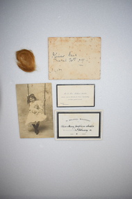
Memorabilia, 1909/1912
These items came from the estates of Dorothy Ardlie (1910-1993) and her sister Agnes Ardlie (1915-1993). They are poignant mementoes of their sister Olive who died in 1912 of gangrenous appendicitis at the age of 6. The three sisters were the daughters of Arthur and Ethel Ardlie of Warrnambool, the granddaughters of the prominent Warrnambool lawyer, William Ardlie and his wife Mary and the great granddaughters of John and Mary Ardlie, pioneer Warrnambool settlers. These mementoes were kept by family members for over 100 years These items are of considerable interest as mementoes of a small child who died early in the 20th century and of the type of bereavement cards used at that time. .1 A black and white photograph produced as a post card. The subject is a young girl on a swing and holding a doll. The photograph has a hole at the top. .2 A bereavement card with black edging, black printing and handwriting in black ink. .3 A bereavement card with black edging and black printing. .4 A small envelope, much stained. This contains a small amount of a child’s hair. .1 Foyle’s Photo Card Liebig St. Warrnambool For Ethel in memory of her little playmate Olive Ardlie .2 In Affectionate Remembrance of Olive Mary Josephine Ardlie who departed this life 24th February 1912 Aged 6 Years .3 Mr & Mrs Arthur Ardlie return sincere thanks for kind sympathy in their great sorrow ‘Aroona’ Warrnambool .4 Olive’s hair, March 31st 09 3 yrs ardlie family, history of warrnambool -
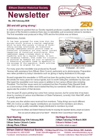 Eltham District Historical Society Inc
Newsletter, Newsletter, No. 250 February 2020
Contents: • 250 and still going strong ! • Our Next Meeting - Wednesday 12th February 2020 • March Excursion - Eltham’s Hidden Creek • Memories and anecdotes of Mario (Maurie/Maurice) Fabbro by Hans Gregory • Early Settlers House, Ely Street, Eltham by Russell Yeoman • Our Town – Part 1 by Sue Bennett • Eltham Cemetery Stories by Richard Pinn o Guido Quarto Fabbro o Gordon Craig Ford • Contacts for the Eltham District Historical Society The Shire of Eltham Historical Society was formed in October 1967. The first newsletter of the Society was issued May 1978 and has been published continuously ever since on a bi-monthly basis. With the cessation of the Shire of Eltham in late 1994, the Society's name was revised to Eltham District Historical Society and this name first appeared with issue No. 103, July 1995. The collection of the Society's newsletters provides a valuable resource on the history of the Society's activities, office bearers and committee members, guest speakers and subjects of historical interest pertinent to the former Shire of Eltham and the Eltham District.A4 newsletter distributed to membersnewsletter, eltham district historical society, reminiscences, zull family, mario fabbro, ely street, guido fabbro, gordon ford, eltham cemetery stories -
 City of Moorabbin Historical Society (Operating the Box Cottage Museum)
Photograph - Wedding Photograph, Alonzo and Mary Box, Box, Alonzo and Mary, 1918
Alonzo Box, who lived in Oakleigh, was the nephew of William and Elizabeth Box, a pioneer settler of Dendy's Special Survey 1841 who purchased 'Box Cottage ' in 1865 and lived there until 1914. Alonzo Box married Mary Kloster/ Closter in 1918. On the Marriage Certificate Mary Box has spelt "Closter" with a "C" and not the "K" of her German heritage. This marriage was taking place during World War 1. Many immigrants would have altered their name at that time. The Box family were early pioneers of the district and raised their family in reconstructed 'Box Cottage'. They established a market garden and sold produce to the Melbourne markets for the colony's increasing population.A large, glass covered, wooden-framed, wedding photograph of Alonzo and Mary Box (nee Kloster/ Closter),married June 12th 1918 is displayed in the reconstructed 'Box Cottage' Museum, Joyce Park, Ormond, Victoria. At front base of mounting of photograph 'Muntz Malvern' is stamped. On back of photograph is written, unsigned, 'Mr & Mrs Alonzo Box/ June 12th 1918/ (Mary Kloster )/photographs, brighton, moorabbin, malvern, box william, box elizabeth, box alonzo, box mary, oakleigh, muntz -
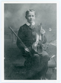 Mt Dandenong & District Historical Society Inc.
Photograph, Edward John Price aged 14
John Lundy-Clarke grew up in the Kalorama/Mt Dandenong area and later in life (1972-74) began to write a comprehensive history of the district working from an original settlement map in an effort to cover all areas. Edward John Price (1898 - 1974) was the son of early settlers on Lot 1 of the Village Settlement Edward Joseph Price and Annie (nee Ross) Price. He was the brother of Charles and Kathleen Price. Edward John married Myra Wilson in 1930.Black and white studio portrait showing well groomed boy holding a violin. Reverse of photograph has handwritten description by John Lundy-Clarke.Edward John Price aged 14. Son of Edward Joseph Price and Annie Ada nee Ross. Farmer, sawmiller, logging contractor,. proprietor of shop at Kew Junction 1935. Quarry master (Kilsyth). Father of Alan and Eddie J. A daughter died young. Married Myra Wilson 1930. Died 1974.edward john price, edward joseph price, annie price, annie ross, kathleen price, charles price -
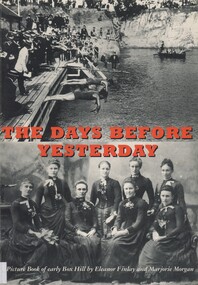 Surrey Hills Historical Society Collection
Book, The days before yesterday: a picture book of early Box Hill, 1993
This book shows a collection of pictures from the days of the earliest settlement of Box Hill through to the 1930s. They show us the clearing of land for the establishment of farms and orchards. We see the early Whitehorse Road which was known as Corduroy Road because of the logs that formed its surface.This publication, originally suggested by Betty Walters, a former Mayor of the City, portrays the evolution of the central area of the City, from the first settlers to 1930. The selection of the pictures by the authors was based on the general interest and quality of the photographs.On the front cover: "Presented to Surrey Hills / History Group / by / Marjorie Morgan"box hill, (mrs) marjorie morgan, (mrs) eleanor finlay, early settlement, 1930s -
 Federation University Historical Collection
Photographs - black and white, Henry John (Jack) Holmes of Ascot and Derrinallum, Victoria
Henry John (Jack) Holmes of Ascot was the eldest son of Henry Smerdon and Edith (nee Pickford) Holmes and brother to William Smerdon [Bill], David Coghill and Elizabeth (m Chatham) On his return from serving in WW2, Jack with his father's help took up a Soldier Settler option and settled at Derrinallum on a portion of Mout Elephant. The holding was named "Launchley Park". Soldiers, like Jack with their families, helped swell the numbers in the district and aided the growth in the town and the services it could provide.Three photographs. .1) Black and white photograph of Henry John (Jack) Holmes from Ascot and then Derinallum .2) and .3) Jack Holmes. jack holmes, chatham-holmes collection, henry smerdon holmes, derrinallum, western desert ww2, soldier settlement, mount elephant -
 Melton City Libraries
Newspaper, James Pinkerton, 1991
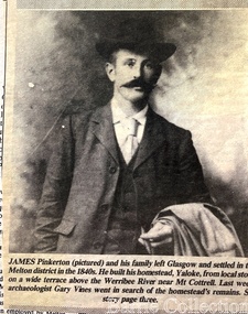
"James Pinkerton, described by fellow settler Isaac Batey as ‘a fine old Scotish [sic] gentleman’, and his wife Margaret established ‘Chamois Ponds’ on Kororoit Creek in the Keilor district in 1840.44 After a fire in 1848, the Pinkerton family moved further west to a holding called Yaloke, on the Werribee River in the Melton district.45 Today, the Surbiton Park water treatment plant operates on part of the Yaloke run. The Pinkerton family is remembered in Melton in part due to the historic graves of the original settler, Margaret Pinkerton, and four of her grandchildren, which were marked by a memorial cairn in 1931. Changes to sewage flood zoning in the area in the 1990s necessitated that these burials be relocated. Members of the Melton & District Historical Society oversaw a project to relocate the Pinkerton graves and cairn 200 metres from their original site to their current resting place at Mount Cottrell. This relocation ceremony took place on 8 November 1992, with the participation of local school students and with Pinkerton descendants playing a central role. This occasion also marked the opening of the Pinkerton Forest Project, which saw 50 hectares of degraded woodland in Surbiton Park protected for regeneration".Photograph of Jame Pinkerton featured in the the Telegraphlocal identities, pioneer families -
 Orbost & District Historical Society
Photograph - black and white photograph
The older lady in this photograph is Hazel Trewin, wife of Abby Trewin of Jarrahmond. The Trewins were a foundation settler/farmer family at Jarrahmond and many members of this family still live in this district. (2025). Albert (Abby) Trewin (b.21.03.1876 d. 01.07.1970) was part of the Trewin family who were early settlers at Jarrahmond near Orbost. Albert was born at Kingston near Ballarat, shifted to Jarrahmond where the house was called "Hillview", located 3 miles from Orbost on the B Road. The Trewin selection at Jarrahmond had many big trees on it and because these looked a bit like Jarrah trees from Western Australia, they names their property Jarrahmond (which became the district location and the name of Jarrahmond School). He cleared the land with bullocks, horses, crosscut saws, burned the stumps, burying some logs which were too big to burn. Then they milked cows, planted maize, had pigs, drove the pigs to Bairnsdale or to Waygara (c. 1915 when the train reached Waygara) on a buggy track through the bush. Pigs went to Dandenong Bacon Factory where they were processed into Dandy Ham. B/W photograph of two women standing. The older woman on the left hand side has her hand on a walking stick, and the other woman appears to be helping her and has her hand outstretched. Behind the two women is a bed an pillows. none -
 Orbost & District Historical Society
black and white photograph, late 19th century / early 20th century
The first settler to occupy the Marlo township area was James Stirling around the year 1875. He built a bark hut on the bluff that had two rooms, bark walls, earthen floors and a shingle roof. By 1884, this structure had expanded to a 9 roomed accommodation house and in 1886 became the Marlo Hotel when a liquor license was granted. The Governor-in-Council declared Marlo to be a township on 18 February 1889. During May 1889, the government surveyor, E.L. Bruce set out 19 sections of the new township, with the first sales of subdivided land occurring the following May. At this time, Stirling's Marlo Hotel was the unofficial hub for the community. It was a general store, accommodation house and the unofficial post office, with settlers taking turns in bringing the mail from Orbost or Cunningham. This continued until Aug 1942, and in 1969 was located in a house adjacent to the Marlo Hotel, before being transferred to the Marlo General Store in this year. The official Post Office List states the Marlo Post Office opened around 1902. in 1925, the "Marlo House" (a nine room accommodation guest house) was granted a liquor licence. The "Marlo House" became "The Marlo Hotel". The Marlo Hotel was popular with many Orbost and district settlers, who travelled to Marlo by horseback or buggy. In the early 20th century the hotel advertised itself as " Under Vice-Regal Patronage. Situated on High Cliff, fronting Ocean, Lakes and Snowy River. Those in search of Health, Rest and Sport should visit Marlo. Boating, Fishing, Shooting, Bathing, Golf. Comfort and Convenience at Marlo Hotel, near Orbost, East Gippsland. Nixon's Cars would meet the train at at Orbost. Fare---6s single, 12s return. Telephone No. 1, Marlo. S, P, STEWART, Proprietor." The Marlo Hotel, perched on the hill overlooking the estuaries and the entrance is a significant building in Marlo. Established in 1886, it has been operating for over 120 yearsAn original black / white photograph and a black / white copy of a party being held under trees on the lawn of the Marlo Hotel. It is a postcard with advertising of Marlo on the back.on back - "Where to spend your holiday - Marlo" on front - "Vice Regal Party at Hotel, Marlo"marlo-hotel -
 Orbost & District Historical Society
black and white photograph, 1936
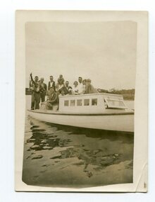
This is a photograph of a fishing party at Marlo, East Gippsland, in 1936. On the back is a description written by Ruby Richardson. Ruby Richarson was born 1902 in Orbost. Her father was Albert Eli and mother Lettice Tomlinson. Ruby had sisters, Mary Agnes Jessie born 1897 and Grace Jane born 1905. Albert Eli Richardson, died in 1851 aged 90i Orbost, His father was given as George Samuel Richardson and mother Jane Farndon, (research - Lois Crisp) The first settler to occupy the Marlo township area was James Stirling around the year 1875. He built a bark hut on the bluff that had two rooms, bark walls, earthen floors and a shingle roof. By 1884, this structure had expanded to a 9 roomed accommodation house and in 1886 became the Marlo Hotel when a liquor license was granted The Governor-in-Council declared Marlo to be a township on 18 February 1889. During May 1889, the government surveyor, E.L. Bruce set out 19 sections of the new township, with the first sales of subdivided land occurring the following May. At this time, Stirling's Marlo Hotel was the unofficial hub for the community. It was a general store, accommodation house and the unofficial post office, with settlers taking turns in bringing the mail from Orbost or Cunningham. This continued until Aug 1942, and in 1969 was located in a house adjacent to the Marlo Hotel, before being transferred to the Marlo General Store in this year. The official Post Office List states the Marlo Post Office opened around 1902.[ In 1925, the "Marlo House" (a nine room accommodation guest house) was granted a liquor licence. The "Marlo House" became "The Marlo Hotel". The Marlo Hotel was popular with many Orbost and district settlers, who travelled to Marlo by horseback or buggy. Marlo has always been a popular destination for fishermen. A small black / white photograph of a group of men and women on a small boat.on back - "Fishing party..................Ruby Richardson"marlo-fishing recreation-fishing -
 Eltham District Historical Society Inc
Ledger, Eltham Road District. Assessment for the Year ending Oct. 14th, 1858, 1857c
... settlers ...The Eltham Roads Board was established in 1856. This is a unique significant record of early settlers in the Shire of Eltham. One of 6 early rate books. This is among the oldest items in the EDHS collection. An article in the Eltham and Whittlesea Shires Advertiser Friday 21 Nov 1941 Page 5 titled: District's Early History states: "The first rate book which is still in existence at the Shire Office is for the year ending October 14, 1858 and is probably the best record possible to indicate the development of the district. At the time properties were rated as follows: Cultivated land. 6d. per acre; pasture land, 1d. per acre: estimated annual value of buildings, etc., 6d in the (pound). The total amount of rate recorded for the year was (pounds)153/14/8. Properties were described as being situated at Lower Plenty, Yarra Yarra, Eltham, Lower Eltham, Kangaroo Ground, Yarra Flats, Diamond Creek and the Yarra."Ledger with printed columns: Number, Name of Occupier, Description, Where situated, Cultivated land, Pasture land, Estimated annual value of buildings, Rate, Remarks. Ledger filled out by hand with 152 entries (not alphabetically arranged). A number of blank pages are included. Copy re-bound in green hard leather look card by Arnall & Jackson Pty Ltd Brunswick, 1968 Inside cover includes a compliments slip taped to the cover from Arnall & Jackson Pty Ltd. with handwritten inscription: "Ian, I hope the hysterical society doesn't get historical about this". Organised 1968 I. Maynard Inside cover includes pasted printed note: RATE OF ASSESSMENT AS FOLLOWS: Cultivated land 6d per acre Pasture land 1 per acre Estimated Annual Value of Buildings, &c., 6d. in the Pound eltham roads board, rate book, rate payers, transaction, pioneers, settlers, 1858, assessment ledger, eltham road district, public records office victoria (prov), rate books, shire of eltham archives -
 Eltham District Historical Society Inc
Ledger, Eltham Road District. Assessment for the Year ending Oct. 14th, 1860 (Version 2), 1859c
... settlers ...The Eltham Roads Board was established in 1856. This is a unique significant record of early settlers in the Shire of Eltham. One of 6 early rate books. This is among the oldest items in the EDHS collection. An article in the Eltham and Whittlesea Shires Advertiser Friday 21 Nov 1941 Page 5 titled: District's Early History states: "The first rate book which is still in existence at the Shire Office is for the year ending October 14, 1858 and is probably the best record possible to indicate the development of the district. At the time properties were rated as follows: Cultivated land. 6d. per acre; pasture land, 1d. per acre: estimated annual value of buildings, etc., 6d in the (pound). The total amount of rate recorded for the year was (pounds)153/14/8. Properties were described as being situated at Lower Plenty, Yarra Yarra, Eltham, Lower Eltham, Kangaroo Ground, Yarra Flats, Diamond Creek and the Yarra."Ledger with printed columns: Number, Name of Occupier, Description, Where situated, Cultivated land, Pasture land, Estimated annual value of buildings, Rate, Remarks, Arrears collected, excused, unoccupied, uncollected and amount actually collected. Ledger filled out by hand with 177 entries (not alphabetically arranged). A number of blank pages are included. This version was slight changes to version one. Inside cover includes pasted printed note: RATE OF ASSESSMENT AS FOLLOWS: Cultivated land 6d per acre Pasture land 2d per acre Unalienated Pasture Land 8d per Acre Estimated Annual Value of Buildings, &c., 6d. in the Pound eltham roads board, rate book, rate payers, transaction, pioneers, settlers, 1860, assessment ledger, eltham road district, public records office victoria (prov), rate books, shire of eltham archives -
 Eltham District Historical Society Inc
Ledger, Eltham Road District. Assessment for the Year ending Oct. 14th, 1861, 1860c
... settlers ...The Eltham Roads Board was established in 1856. This is a unique significant record of early settlers in the Shire of Eltham. One of 6 early rate books. This is among the oldest items in the EDHS collection. An article in the Eltham and Whittlesea Shires Advertiser Friday 21 Nov 1941 Page 5 titled: District's Early History states: "The first rate book which is still in existence at the Shire Office is for the year ending October 14, 1858 and is probably the best record possible to indicate the development of the district. At the time properties were rated as follows: Cultivated land. 6d. per acre; pasture land, 1d. per acre: estimated annual value of buildings, etc., 6d in the (pound). The total amount of rate recorded for the year was (pounds)153/14/8. Properties were described as being situated at Lower Plenty, Yarra Yarra, Eltham, Lower Eltham, Kangaroo Ground, Yarra Flats, Diamond Creek and the Yarra."Ledger with printed columns: Number, Name of Occupier, Description, Where situated, Cultivated land, Pasture land, Estimated annual value of buildings, Rate, Remarks, Arrears collected, excused, unoccupied, uncollected and amount actually collected. Ledger filled out by hand with 185 entries (not alphabetically arranged) and summary section. A number of blank pages are included. Inside cover includes pasted printed note: RATE OF ASSESSMENT AS FOLLOWS: Cultivated land 6d per acre Pasture land 2d per acre Unalienated Pasture Land 8d per Acre Estimated Annual Value of Buildings, &c., 6d. in the Pound eltham roads board, rate book, rate payers, transaction, pioneers, settlers, 1861, assessment ledger, eltham road district, public records office victoria (prov), rate books, shire of eltham archives -
 Eltham District Historical Society Inc
Ledger, Eltham Road District. Assessment for the Year ending Oct. 14th, 1862, 1861c
... settlers ...The Eltham Roads Board was established in 1856. This is a unique significant record of early settlers in the Shire of Eltham. One of 6 early rate books. This is among the oldest items in the EDHS collection. An article in the Eltham and Whittlesea Shires Advertiser Friday 21 Nov 1941 Page 5 titled: District's Early History states: "The first rate book which is still in existence at the Shire Office is for the year ending October 14, 1858 and is probably the best record possible to indicate the development of the district. At the time properties were rated as follows: Cultivated land. 6d. per acre; pasture land, 1d. per acre: estimated annual value of buildings, etc., 6d in the (pound). The total amount of rate recorded for the year was (pounds)153/14/8. Properties were described as being situated at Lower Plenty, Yarra Yarra, Eltham, Lower Eltham, Kangaroo Ground, Yarra Flats, Diamond Creek and the Yarra."Ledger with printed columns: Number, Name of Occupier, Description, Where situated, Cultivated land, Pasture land, Estimated annual value of buildings, Rate, Remarks, Arrears collected, excused, unoccupied, uncollected and amount actually collected. Ledger filled out by hand with 184 entries (not alphabetically arranged) and summary section. A number of blank pages are included. Inside cover includes pasted printed note: RATE OF ASSESSMENT AS FOLLOWS: Cultivated land 6d per acre Pasture land 1/2d per acre Unalienated Pasture Land 1/28 per Acre Estimated Annual Value of Buildings, &c., 6d. in the Pound eltham roads board, rate book, rate payers, transaction, pioneers, settlers, 1862, assessment ledger, eltham road district, public records office victoria (prov), rate books, shire of eltham archives -
 Eltham District Historical Society Inc
Ledger, Eltham Road District. Assessment for the Year ending Oct. 14th, 1863, 1862c
... settlers ...The Eltham Roads Board was established in 1856. This is a unique significant record of early settlers in the Shire of Eltham. One of 6 early rate books. This is among the oldest items in the EDHS collection. An article in the Eltham and Whittlesea Shires Advertiser Friday 21 Nov 1941 Page 5 titled: District's Early History states: "The first rate book which is still in existence at the Shire Office is for the year ending October 14, 1858 and is probably the best record possible to indicate the development of the district. At the time properties were rated as follows: Cultivated land. 6d. per acre; pasture land, 1d. per acre: estimated annual value of buildings, etc., 6d in the (pound). The total amount of rate recorded for the year was (pounds)153/14/8. Properties were described as being situated at Lower Plenty, Yarra Yarra, Eltham, Lower Eltham, Kangaroo Ground, Yarra Flats, Diamond Creek and the Yarra."Ledger with printed columns: Number, Name of Occupier, Description, Where situated, Cultivated land, Pasture land, Estimated annual value of buildings, Rate, Remarks, Arrears collected, excused, unoccupied, uncollected and amount actually collected. Ledger filled out by hand with 181 entries (not alphabetically arranged) and summary section. A number of blank pages are included. Inside cover includes pasted printed note: RATE OF ASSESSMENT AS FOLLOWS: Cultivated land 6d per acre Pasture land 1/2d per acre Unalienated Pasture Land 1/28 per Acre Estimated Annual Value of Buildings, &c., 6d. in the Pound eltham roads board, rate book, rate payers, transaction, pioneers, settlers, 1863, assessment ledger, eltham road district, public records office victoria (prov), rate books, shire of eltham archives -
 City of Moorabbin Historical Society (Operating the Box Cottage Museum)
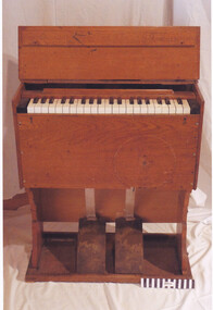
Instrument - 'Estey' Harmonium (Portable), Circa 1870
... settlers ...Circa 1870, “Estey”, American-made, small Harmonium, (commonly known as a Gospel Organ). Initially purchased by Mr John Box, This example folds up into a small wooden case. It was often borrowed and could frequently be seen on the roadside, waiting to be picked up by horse and cart for delivery to a place of worship, often a local hall or private home. This organ was donated to the Baptist Church in the 1920s, from the estate of John Box, and was in constant use. This 'Estey' harmonium belonged to the local Bentleigh Baptist Church, Vickery Street, Bentleigh. It was often borrowed for delivery to a place of worship, often a local hall. There was also a “Methodist Mission to Chinese”, located in Lydia Street, Bentleigh, where the Methodist religion was taught to those interested Chinese. Pioneer settlers welcomed the support and fellowship provided by their gatherings for regular religious worshipCirca 1870, “Estey”, American, small Harmonium, (commonly known as a Gospel Organ). This example folds up into a small, wooden case so that it could be easliy transported to Religious Servicesmoorabbin, harmonium, baptist church, pioneers, settlers, bentleigh, worship, mckinnon, cheltenham, organs, estey, methodist mission -
 Orbost & District Historical Society
newspaper clippings, 1928 - 1975
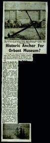
These newspaper articles were collated by Mary Gilbert. Mary Isabelle Gilbert was born in 1905 in Orbost, Australia. She was born to John Gilbert and Annie Cameron Gilbert, and had seven sisters and one brother. Four siblings died at a young age. She was a teacher historian loved and respected by her family and the wider community.These articles are contemporary records of events in the history of Orbost and as such are useful reference tools.A manila folder containing black / white newspaper cuttings of articles relating to the local history of Orbost. They are from the Snowy River Mail. 746.1 is titled, "Historic anchor for Orbost Museum". 746.2, August 9, 1967, is titled, ""Orbost Historical Museum". 746.3 is titled, "When The Snowy Was Angry". On the back is "Resident's Sudden Death - Mrs Ada Bowtell (67)". 746.4 from 1934 is titled, "The Duke's Visit - Welcome at Cann River'. 746.5, Wednesday November 24, 1954 is titled, "Naming of Orbost District Landmarks". 746.6, Wednesday November 24, is titled, " Convict First White Settler in Orbost District?". 746.7, Wednesday, July 25, 1928 is titled, " Dedication of St James' Memorial Church, Orbost". 746.8 and 746.9, Wednesday September 24, 1975 are titled, "Piece of History Returns".orbost- museum anchor-orbost street-names-orbost st-james'-orbost -
 Bendigo Historical Society Inc.
Document - FAMILY HISTORY ''THE STORY OF THE GAYLARDS''
Family history ''The Story of the Gaylard's'' written (dictated by?) Ella Gaylard, 1967. 16 page typewritten document tracing family's arrival in Australia [Central Victoria - Bendigo (Sailor's Gully), Dunolly, Toolleen] and childhood recollections of the author. Mention of the following: the Lamperd family (original settlers??) and cousins, the Chubb family (the safety lock makers).; Auntie Clark (Eliza Ann); Auntie Bowles (Mary Ann). This is a well written account of life in the region and warrants further study - there is mention of many people by name but surnames may be difficult to determine. Mention of places in addition - e.g. author attended Quarry Hill State School where her father was for some time a teacher. This account is typewritten on both sides of foolscap paper - additional photocopied copy also (but this missing pages 1 & 2).Ella Gaylandperson, family, gaylards, ella gaylard, 1967. sailor's gully, dunolly, toolleen, lamperd family, chubb family, quarry hill state school. -
 Ballarat Heritage Services
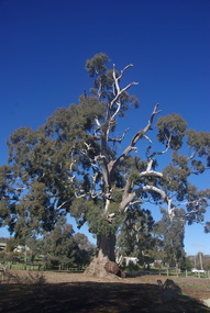
Photograph - Photograph - Colour, Clare Gervasoni, Big Tree, Guildford, Victoria, 2017, 16/07/2017
The Big Tree is listed a a tree of State significance on the National Trust's Register of Significant Trees of Victoria for its outstanding size, curious fusion of branches, as an outstanding example of the species and as an important landmark.A number of colour photographs of Guildford's Big Tree - a River Red Gum (Eucalyptus camaldulensis). The tres is believed to be one of the largest examples of the species in Victoria, and has been recorded as having a height of 30 metre, a canopy spread of 34 metres, and a trunk circumference of 9.35 metres. The tree was already an ancient giant when white settlers first arrived in the 1840s. On Saturday evening, February 28th 2015, just as dusk was falling, Guildford was hit hard by tornado-like winds, felling the big cottonwood tree down by the river, and tearing limbs from the iconic Big Tree, reducing it by an estimated one third. The debris has been cleared since then and the tree seems to have survived its ordeal, though its size is certainly diminished.big tree, guidlford, river red gum -
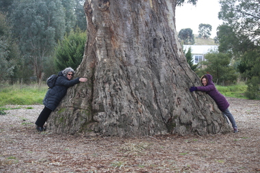 Ballarat Heritage Services
Photograph - Photograph - Colour, Clare Gervasoni, Clare Gervasoni and Ann Gervasoni at the Guildford Big Tree, 2017, 16/07/2017
The Big Tree is listed a a tree of State significance on the National Trust's Register of Significant Trees of Victoria for its outstanding size, curious fusion of branches, as an outstanding example of the species and as an important landmark.A photographs of Guildford's Big Tree - a River Red Gum (Eucalyptus camaldulensis). The tre-es is believed to be one of the largest examples of the species in Victoria, and has been recorded as having a height of 30 metre, a canopy spread of 34 metres, and a trunk circumference of 9.35 metres. The tree was already an ancient giant when white settlers first arrived in the 1840s. On Saturday evening, February 28th 2015, just as dusk was falling, Guildford was hit hard by tornado-like winds, felling the big cottonwood tree down by the river, and tearing limbs from the iconic Big Tree, reducing it by an estimated one third. The debris has been cleared since then and the tree seems to have survived its ordeal, though its size is certainly diminished.big tree, guidlford, river red gum -
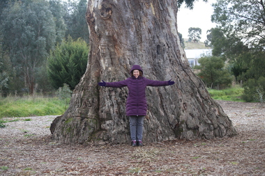 Ballarat Heritage Services
Photograph - Photograph - Colour, Clare Gervasoni, Ann Gervasoni at the Guildford Big Tree, 2017, 16/07/2017
The Big Tree is listed a a tree of State significance on the National Trust's Register of Significant Trees of Victoria for its outstanding size, curious fusion of branches, as an outstanding example of the species and as an important landmark.A photographs of Guildford's Big Tree - a River Red Gum (Eucalyptus camaldulensis). The tre-es is believed to be one of the largest examples of the species in Victoria, and has been recorded as having a height of 30 metre, a canopy spread of 34 metres, and a trunk circumference of 9.35 metres. The tree was already an ancient giant when white settlers first arrived in the 1840s. On Saturday evening, February 28th 2015, just as dusk was falling, Guildford was hit hard by tornado-like winds, felling the big cottonwood tree down by the river, and tearing limbs from the iconic Big Tree, reducing it by an estimated one third. The debris has been cleared since then and the tree seems to have survived its ordeal, though its size is certainly diminished.big tree, guidlford, river red gum