Showing 3818 items matching "1890s-1930s"
-
 Brighton Historical Society
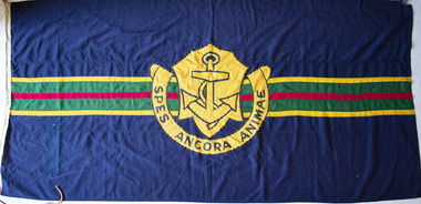
Flag, School flag, circa 1914 - 1956
This flag was used by Esperance Girls School, a private school based in Brighton from 1894-1956. Esperance was established in 1894 at 6 Normanby Street by Misses Emsie, Marion, Gussie and Daisy Beaver. The four sisters came from a formerly-prosperous land-owning family that had suffered badly as a result of the depression of the early 1890s. At a time when few occupations were open to gentlewomen, running a school provided the sisters with a respectable means of supporting themselves. Notable teachers at Esperance during the 1890s included elocution mistress Miss Jeannie Taylor, who would later become better known as the author Mrs Aeneas Gunn. In 1924 the school was sold to Miss Marian Taylor and Miss Christina McMillan, who had previously served as joint principals of Alexandra College in Hamilton between 1909 and 1913. Both women had strong family connections to Brighton: Christina was the granddaughter of early pioneer Archibald McMillan and Marian was a relative of long-serving town clerk J. H. Taylor. The new principals relocated the school to a large two-storey house on the corner of Park Street and Esperance Avenue, where it remained until its closure. They operated the school until 1950, when they sold it to a Miss Bury, who in turn sold it to the local Baptist Church in 1956. Following this final sale, the school continued for another four terms before closing.Navy blue flag, both sides featuring a large yellow-gold crest in centre, containing image of an anchor and surrounded by semicircular scroll with the motto "SPES ANCORA ANIMAE". Background features horizontal green stripe across centre, containing smaller red stripe and bordered on each side by yellow stripes.esperance girls school, flag, school flag -
 NMIT (Northern Melbourne Institute of TAFE)
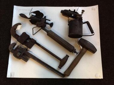
Plumbing tools: CTS and PTS 1920s onwards, Plumbing tools and texts used in teaching 1920s
A number of Plumbing tools dating from 1880s-1970s and used in teaching at Collingwood Technical School then also at Preston Technical School and at Northern Metropolitan College of TAFE's Heidelberg campus. Includes: Kerosene blow torch X 2 (1930s-); Stillson Grips; Pipe Cutter; Mash hammer; Adjustable spanner X 3 different sizes; Caulking tool; 5 way tee, 2X3 way tee, 4 way tee (1930s-); Old Handmade lead traps (student work) X 2; Metal tool tray holding; Offset adjustable spud spanner; Pear shaped lead working mallet; Bossing tool for lead work (1880s-1920s); Soldering iron (1920s-); Set square; Large screwdriver; Also Plumbing texts: • Problems for elementary physics, new rev. edn., by Thomas Tasker and Alexander Boden, Science Press, Sydney, 1966. • Gasfitting. Printed and published by McCarron Bird Pty. Ltd. [Melbourne] • Trade science for plumbing apprentices, Education Dept. Victoria, 1954 • Sanitary Plumbing and water supply, Dept. of Labour • Gasfitting, produced by members of the Colonial Gas Association Limited, Gas and Fuel Corporation of Victoria, and the Technical Division of the Education Department of Victoria. Rev metric edn. 1976 • Mechanical world year book 1953, Manchester Emmott & Co., 1953 collingwood technical school, preston technical school, northern metropolitan college of tafe, plumbing tools, plumbing texts, nmit -
 Warrnambool and District Historical Society Inc.
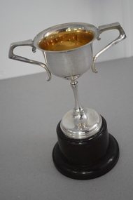
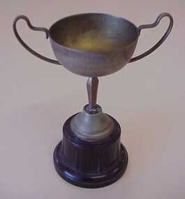
Trophy, ICISA Deck Quoits 1935, 1935
This trophy is one of several from the 1930s that were awarded as part of the inter-church indoor sports competitions held in Warrnambool. One of the sponsors of these competitions was Fletcher Jones, the well-known clothing manufacturer. The head office and major factory of the Fletcher Jones business were in Warrnambool. This trophy was awarded to the Congregational Men’s Institute for deck quoits. The game of quoits consists of competitors throwing four or five rings or hoops on to a raised spike some metres away. The hoops are generally made of plaited rope and the game is said to have been started or popularized by sailors on board ship. In deck quoits the raised spike is usually replaced by concentric circles drawn on the playing surface. This game became very popular on ocean liner cruises from the 1930s on. The Congregational Men’s Institute was a leading men’s activity group in Warrnambool in the 1930s. A Congregational Church was opened in Liebig Street in Warrnambool in 1864 and transferred to Henna Street in 1940. This Henna Street church was sold to the Salvation Army in 1979 when the Congregational Church merged with the Methodist Church to form the Uniting Church. This trophy is of interest as a memento of the now-defunct inter-church sporting competitions held in Warrnambool in the 1930s.This is an electro-plated nickel silver cup with two side handles, a thin stem and a silver base. The cup is mounted on a Bakelite stand. ‘I.C.I.S.A. Deck Quoits Championship Won by C.M.I. 1935’congregational church, warrnambool, inter-church sporting competitions, warrnambool, history of warrnambool -
 Warrnambool and District Historical Society Inc.
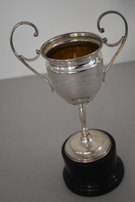
Trophy, ICISA Grand Aggregate 1934, 1934
This cup is one of several from the 1930s that were awarded as part of inter-church indoor sporting competitions in Warrnambool. One of the sponsors of these competitions was Fletcher Jones, the well-known clothing manufacturer. He had his head office and major factory in Warrnambool. This trophy has been awarded to the grand aggregate winner of 1934, the Congregational Men’s Institute (C.M.I.), a leading church activity group for men in Warrnambool in the 1930s. A Congregational Church was opened in Liebig Street. Warrnambool in 1864 and transferred to Henna Street in 1940. This Henna Street church was sold to the Salvation Army in 1979 when the Congregational Church merged with the Methodist Church to form the Uniting Church. This trophy is of interest as a memento of the now-defunct inter-church sporting competitions held in Warrnambool in the 1930s. This is an electro-plated nickel silver cup with two side handles and a narrow stem on a silver base. The cup is mounted on a Bakelite stand. ‘Inter-Church Indoor Sports Association Cup Grand Aggregate Won by C.M.I. 1934’ congregational church warrnambool, inter-church sports competitions, warrnambool -
 Warrnambool and District Historical Society Inc.
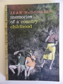
Book, Memories of a Country Childhood, 2008
This is a book by Jean McDonald (nee Henderson) telling of her childhood experiences. Born in 1924 Jean McDonald was one of seven children who grew up at Rivery Park, a dairy farm in Grassmere in the 1930s and 40s. She went to school in Cooramook and Warrnambool. This book is of interest as it describes the life of Jean McDonald in Grassmere. It is an important social history of the life and times of a local woman. This is a soft cover book of 189 pages. The front cover has a coloured photograph of three children near a stream and the back cover has an extract from the book and some comments on it. The book contains ten chapters and many black and white photographs. ‘M. Jansen’ jean mcdonald, grassmere, cooramook, rural life in the western district -
 Warrnambool and District Historical Society Inc.
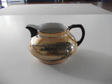
Jug, Souvenir Warrnambool Jug, Between 1921 and 1938
This is a souvenir jug showing an image of the boat sheds (Proudfoots) at the mouth of the Hopkins River, Warrnambool. It would have been purchased in the 1920s or 1930s. These boatsheds were erected for Thomas Proudfoot in 1885. At that time the sheds housed the boats of the local Gordon Rowing Club. This jug is of interest as an example of the type of souvenir available to tourists and locals in the Warrnambool district in the 1920s and 30s. This is a lustre ware china jug with a black handle and a black lip and black edging around the opening. The jug has a squat spherical shape and has gold colouring with an image in black and grey of the boatsheds at the mouth of the Hopkins River, Warrnambool. The lettering is in black and on the base are the maker’s symbols. ‘Boat Houses on the Hopkins, Warrnambool ’23 R.K.G. Made in Cechoslov (sic)’ proudfoots boatsheds. warrnambool, hopkins river, warrnambool, history of warrnambool -
 Warrnambool and District Historical Society Inc.
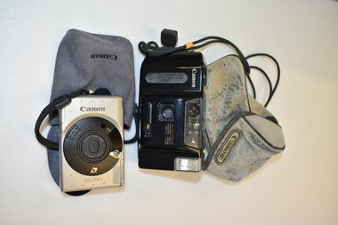
Cameras (2), Canon Co. Inc, Late 20th century
These cameras were made in Japan by the Canon Company which dates from the 1930s. Canon cameras were, and still are very popular as they are compact and have a simple ‘point and shot’ mechanism. The taking of family photographs has been a hobby for over 100 years.These cameras have no known local provenance but are retained for display purposes. .1 This is a Canon Elph Camera. It is rectangular in shape and mainly silver-coloured with a black lens. A black cord for holding the camera is attached. The camera is in a grey cloth bag. .2 This is a Canon Sprint camera. It is rectangular in shape and has a black body. A black cord for holding the camera is attached. The camera is in a buff-coloured cloth bag. This is slightly scuffed. .1 Canon Elph Canon Inc. Made in Japan 3104104 .2 Canon Sprint Approved JC11 canon cameras, history of warrnambool -
 Federation University Historical Collection
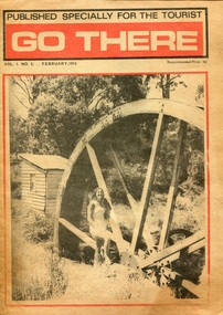
Newspaper - Newspaper - Special Publication, Jeff Zilles, ZILLES COLLECTION: Go There, Vol. 1. No.2. February 1974, 1974
Zilles Printers was begun by Lewis Zilles in the early 1930s. It was in McKenzie Street Ballarat. His son Jeffrey also became a printer - letterpress, offset and screen printer. The business became Zilles Printers/Graphics and was in Armstrong Street and later Bell Street Ballarat.Go There was a newspaper published especially for tourists, and covered Ballarat, Daylesford, Castlemaine, Kyneton, Malmsbury, Trentham, Greendale, Hepburn Springs, Bendigo, Guidlford, Newstead.ballarat, daylesford, castlemaine, kyneton, malmsbury, trentham, greendale, hepburn springs, bendigo, guidlford, newstead, newbury, waterwheel, waterwheel farm, jack smales, val henderson, ken lock, advertisements, castlemaine market building, weerona tropical aquarium, maldon, merlo, newstead pottery, trevor whelan, welshman's reef, newstead butter, eureka swimming pool -
 Federation University Historical Collection
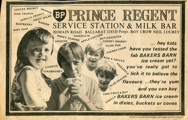
Newspaper - Newspaper - advertisement, Jeff Zilles, ZILLES COLLECTION: Prince Regent Service Station and Milk Bar Advertisement, c1975
Zilles Printers was begun by Lewis Zilles in the early 1930s. It was in McKenzie Street Ballarat. His son Jeffrey also became a printer - letterpress, offset and screen printer. The business became Zilles Printers/Graphics and was in Armstrong Street and later Bell Street Ballarat.Newspaper advertisement for Prince Regent Service Station and Milk Bar.prince regent service station and milk bar advertisement, main road ballarat east -
 Federation University Historical Collection
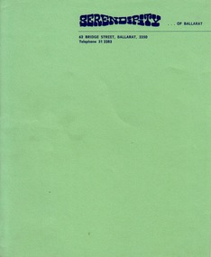
Document - Document - Letterhead, ZILLES COLLECTION: Letterhead for Serendipity of Ballarat
Zilles Printers was begun by Lewis Zilles in the early 1930s. It was in McKenzie Street Ballarat. His son Jeffrey also became a printer - letterpress, offset and screen printer. The business became Zilles Printers/Graphics and was in Armstrong Street and later Bell Street Ballarat.Bright green textured paper with navy blue printAddress: 62 Bridge Street Ballarat 3350zilles printers, ballarat, serendipity of ballarat -
 Federation University Historical Collection
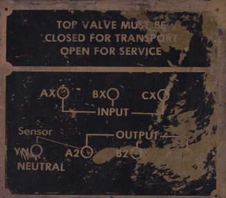
Sign - Sign - Instructions, ZILLES COLLECTION: Metal Plate with instructions: Top Valve
Zilles Printers was begun by Lewis Zilles in the early 1930s. It was in McKenzie Street Ballarat. His son Jeffrey also became a printer - letterpress, offset and screen printer. The business became Zilles Printers/Graphics and was in Armstrong Street and later Bell Street Ballarat.Gold colour metal plate with black sectionszilles printers -
 National Wool Museum
Photograph
Photograph of Margaret Hooper who was in charge of the Unity Club which was situated in Malop Street. Mrs Alsop was a mill worker from early 1930s till early 1970s. She worked at Federal and Foster Mills in Geelong District and Yarra Falls, Melbourne.Margaret / Hoopertextile mills sporting teams, textile mills staff, federal woollen mills ltd, sport, textile mills - sporting teams, textile mills - staff -
 Parks Victoria - Gabo Island Lightstation
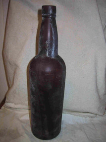
Bottle
Embossing indicates that the brown glass bottle contained Penfold brand wine, a South Australian wine company formed in 1913. This particular bottle was the shape used for their fortified wines and would date between c.1917 and the early 1930s. It was found on the beach or in the sea.The brown glass bottle has a lip and collar with a tall neck and narrow shoulder and would have had a cork stopper. " PENFOLD / THIS BOTTLE IS THE PROPERTY OF / PENFOLDS WINES" -
 Linton and District Historical Society Inc
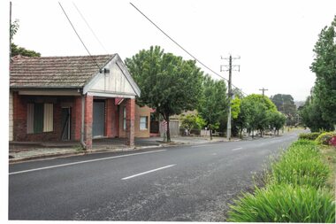
Photograph, Former Bennett Bros Garage Building, Sussex Street, Linton, 2014
The Bennett Bros Garage operated in Linton from the 1930s-1950s. The building is at 79A Sussex Street. Next to the garage building can be seen the building at 81 Sussex Street. In the first half of the twentieth century, it was a shop and residence and operated as a greengrocery and confectionery store.Colour photo which shows a brick building in a somewhat dilapidated condition, with windows and doors boarded up. The building has a tiled roof.bennett bros garage, shepherd's greengrocery and confectionery store, jane craine's confectionery shop, 79a sussex street linton, 81 sussex street linton -
 Greensborough Historical Society
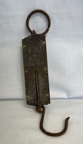
Domestic object - Scales, L.F. & C, Pocket Balance Scales, 1900 c
Small, very old pocket balance scales 0 L.F. & C. Made in New York. Possible belonged to and used by the Bishop family 1900s to 1930s. The front plate is brass. The wording on the scales is "Not Legal For Use In Trade". The scales measure up to 25lb.Small very old pocket balance scales, front plate is brass. The wording on the scales is Not Legal For Use In Trade,. Scales measure up to 25lb.scales, kitchenware -
 Ithacan Historical Society
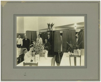
Photograph, Interior of the Spot Cafe, Melbourne
The Spot Cafe was in Elizabeth Street, Melbourne and owned by Athanasios Raftopoulos, Michalis Mavrokefalos and Anastasios Flocas. It was one of the many cafes owned and run by Ithacans in Melbourne's CBD in the 1930s and 1940s. Arthur Raftopoulos and Hector Andrews are standing 2nd and 3rd left in the photograph. Many Ithacans established businesses throughout the CBD and inner suburbs. These establishments also provided employment for other family members and friends as during the first half of the twentieth century migrants from Southern Europe were often unable to find employment in the wider Australian community.A black and white photograph mounted on grey board with a darker grey border of the interior of a restaurant. Tables set out with white tablecloths are in the foreground with four men standing behind them and a man and two ladies are standing in curtained cubicles in the background.ithacan businesses. -
 Greensborough Historical Society
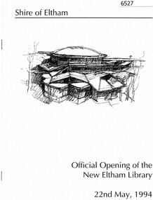
Booklet, Official opening of the new Eltham Library, 22nd May, 1994, 22/05/1994
Outline of library services to the Eltham community since the early 1930s including the Heidelberg Regional Library Service, which was replaced by the newly formed Yarra Plenty Regional Library Service in 1985. This booklet was published on the occasion of the opening of the new Eltham branch library in 1991. 8 p., black print on off white paper, photographseltham library, yarra plenty regional library -
 Glenelg Shire Council Cultural Collection
Souvenir - Cloth Badges, n.d
The Margaret Rose Caves is a magnificent limestone cave that was found by local property owners in the 1930s who requested permission from Buckingham Palace to name the site after future Queen Elizabeth II's younger sister. Parks Victoria now manages the cave area.Cloth badge, Princess Margaret Rose Caves Vic, black background; white stalagmite framed by red ribbon with black lettering; yellow embroidered border on badge; white backing.souvenir, princess margaret rose caves -
 National Wool Museum
Trophy
Trophy won by Federal Mills B team captain. N. Bawden (donor) in a Gymkhana in 1936. Mrs Alsop was a mill worker from early 1930s till early 1970s. She worked at Federal and Foster Mills in Geelong District and Yarra Falls, Melbourne.GYMKHANA 1936 FEDERAL B N BAWDEN "CAPT"textile mills - sporting teams textile mills - staff sporting teams, federal woollen mills ltd classweave industries pty ltd, sport, textile mills - sporting teams, textile mills - staff, sporting teams -
 Hume City Civic Collection
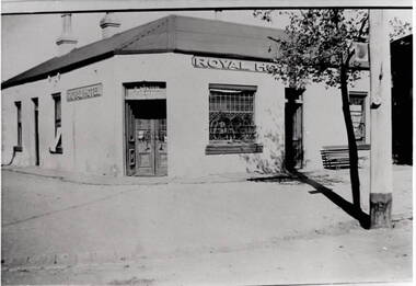
Photograph, Royal Hotel
This is an image of the original single storey Royal Hotel building which was on the corner of Brook and Evans Streets. In the 1930s the single storey structure was demolished after a fire and replaced with a double storey Art Deco red brick building, which still stands on the same site.At one stage there were four hotels in Evans Street between Station Street and Brook Street. At some stage the Millett family owned them. The Royal and the Olive Tree (formerly the Railway) hotels remain on their original site but not in their original appearance.A black and white photograph with a cream border of a single storey hotel building with a headlight window on the RHS of the corner entry doorway, which also has lead light windows. A young tree and power pole are seen on the RHS of the image. hotels, royal hotel, s.winter, t. millett -
 Flagstaff Hill Maritime Museum and Village
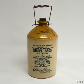
Container - Stoneware Demijohn, Bendigo Pottery , 1904-1930s
This Sharpe Bros. one gallon stoneware Demijohn is in excellent condition and includes its original stopper. It was made between 1904 and 1930, the date from the patent of the handle until the time that the factory no long produced returnable items. The bottle was once part of Dr W.R. Angus' household and is part of the W.R. Angus Collection and could have been purchased from Warrnambool's Sharpe Bros. factory. SHARPE BROS. 1903-1972- The first Sharpe Bros. cordial factory was opened in Dunedin, New Zealand, in 1903 by English prohibition brothers John and Percy Sharpe. Sharpe Bros. made ‘health’ beverages that were non-alcoholic drinks such as ginger beer, ginger ale, lime juice, soda and cordials. The containers of these drinks were not sold with the drinks but were marked as returnable items, to be cleaned and re-used, until this practice ceased in the 1930s. Sharpe Bros. made a niche in the soft drink market by delivering drinks by horse and cart to its customers’ homes. John Sharpe patented the unique wire spiral handle in 1904. By 1905 the New Zealand company also had factories in Australia. By 1910 the company had over 20 factories including Wanganui, New Zealand; Adelaide, Albury, Ballarat, Bathurst, Forbes, Geelong, Goulburn, Lithgow, Melbourne, Newcastle, Orange, Sydney, Tamworth, Warrnambool and Wollongong. The Warrnambool factory was established in 1919 and existed until 1951. The company won awards at Australian exhibitions for its carbonated drinks, including First Prize for its ginger beer made in the Brisbane factory. The company was taken over in 1962 by Tarax Drinks Holdings Ltd, which was in turn taken over by Cadbury Schweppes in 1972. W.R. Angus Collection- The W R Angus Collection spans from 1885 to the mid-1900s and includes historical medical and surgical equipment and instruments from the doctors Edward and Thomas Ryan of Nhill, Victoria. Dr Angus married Gladys in 1927 at Ballarat, the nearest big city to Nhill where he began as a Medical Assistant. He was also Acting House surgeon at the Nhill hospital where their two daughters were born. He and his family moved to Warrnambool in 1939, where Dr Angus operated his own medical practice. He later added the part-time Port Medical Officer responsibility and was the last person appointed to that position. Dr Angus and his wife were very involved in the local community, including the early planning stages of the new Flagstaff Hill, where they contributed to the layout of the gardens. Dr Angus passed away in March 1970.This stoneware Demijohn is connected to the history of Warrnambool, as it was owned by the daughter of Dr W. R. Angus and his wife Gladys. It is part of the W.R. Angus Collection, which is notable for still being located at the site connected to Doctor Angus, Warrnambool’s last Port Medical Officer. It is also connected through its manufacturer Sharpe Bros. which had a branch in Warrnambool from 1919 to 1951, overlapping the time when the Angus family resided there from 1939 to the 1970s. The bottle is also significant as an example of the early-20th-century beverages found in local households and could have been purchased from the local Sharpe Bros. factory.This stoneware Demijohn is glazed, with a brown neck with internal thread and shoulders and a cylindrical cream base. The one gallon bottle has a flat, black stopper with a cork stem and a rubber, threaded tip. The ‘U’ shaped wire carry handle has a spiral of wire around the handpiece. An overhanging lip is on top of the bottle’s short neck above its rounded shoulder. The clay has been joined at the base of the neck, shoulder and body. The underneath is unglazed. The brown glazing on the shoulder has a run mark. Inscriptions are on the stopper and bottle. This container is part of the W.R. Angus Collection.Stamped in black on the shoulder: “KEEP THE / STOPPER TIGHT” Stamped in black on the body: “THIS JAR IS THE ABSOLUTE PROPERTY OF AND MUST BE RETURNED TO SHARPE BROS. AUSTRALIA / & NEW ZEALAND. ORIGINAL & LARGEST HYGIENIC BREWERY. CAUTION Persons Damaging, Willfully Retaining, Trading with or Misappropriating the Use of this Jar WILL BE PROSECUTED “ Stamped in script writing: “Sharpe Bros. TRADE - - - ED “ Embossed on the stopper: “AUSTRALIA AND NEW ZEALAND, SHARPE BROS.”flagstaff hill, warrnambool, maritime village, maritime museum, shipwreck coast, great ocean road, dr w r angus, dr roy angus, dr ryan, sharpe bros., bendigo pottery, bottle, stoneware bottle, demihohn, one gallone bottle, soft drink, non-alcoholic drink, drink container, jar, jug, warrnambool soft drink, hygienic brewery, cordial factory, new zealand, australia, john sharpe, percy sharpe, non-alcoholic, spiral wire handle, ginger beer, w.r. angus collection, demijohn -
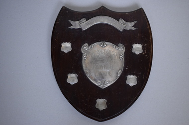 Warrnambool and District Historical Society Inc.
Shield, 1947
This trophy has been presented to the Warrnambool & District Football League by the South Warrnambool Football Club. This latter club still plays in the Hampden Football League and dates back to the 1880s and possibly beyond and has always been a traditional rival of the Warrnambool Football Club. West End Football Club dates back to the 1890s and joined with the Allansford Football Club in the 1960s to form the West End Allansford team. In 2001 the name ‘West End’ was dropped from the club’s name. Russells Creek Football Club was established in 1931 and still plays in the Warrnambool & District Football League which dates back to the early 1900sThis football trophy is of interest as it comes from the mid 20th century and concerns two local Warrnambool football clubs still existing today and one club that no longer exists.This is a wooden trophy in the shape of a shield. It has a silver scroll on the top and a silver heart shape in the middle. There is a cord on the back of the shield attached by metal hooks for hanging purposes. There are five small shields with etched writing on four of these. The shield is a little scratched. ‘South Warrnambool Football Club Shield’ ‘Warrnambool & District Football League’ ‘R.C.F.C. Premiers 1947 Tom Zanos (Captain) H. Drewitt (Coach)’ ‘W.E.F.C. Premiers 1948 P. Lake Capt. & Coach G.R.Thomas Pres.’ ‘W.E.F.C. Premiers 1949 W.L. ‘Jack’ McMurrick Capt. & Coach’ ‘West End F.C. Premiers 1950 W.L. McMurrick Capt. & Coach’ south warrnambool football club, warrnambool & district football league -
 Warrnambool and District Historical Society Inc.
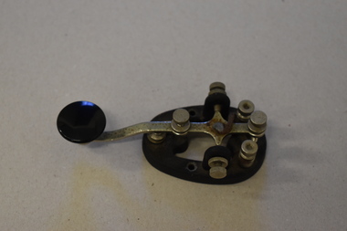
Morse code key, Mid 20th century
This is a Morse Code key. Morse Code is a method of transmitting text information using short and long signals (‘dots and dashes’). It is named after Samuel Morse, the inventor of the telegraph and was developed in the 1860s. It was used extensively in the 1890s for early radio communication before it was possible to transmit voice and continued to be used in the 20th century along with voice transmission , especially by amateur radio persons. It was also used in military and naval communication but not so much today. It is believed that this Morse Code key belonged to Ted Salamy, a jeweller and the first person in Warrnambool to hold an amateur radio licence (1924 Call Sign A3AJ, the 35th licence issued in Victoria).This Morse Code key is of interest as an object more used in the past, especially by amateur radio persons. It is believed to have been the property of Ted Salamy, the first person in Warrnambool to hold an amateur radio licence. This is a metal Morse Code key with an oval metal base. It has three screws inserted in the base and two more screws attached to the sides of the base. There is a key lever on top of the base and this is adjustable. The hinge on which the key lever sits is missing. The lever has a round black knob at one end. ‘Made in U.S.A. H15.682’ Wm.M. Nye Co Inc. Bellevue W.A.’ morse code key, ted salamy,, history of warrnambool -
Eltham District Historical Society Inc
Folder, Robert Lowman, 1882
Robert Lowman, Christmas Hills, 1882 Lowman built his Lowman's Hotel or Lowman's Folly on Osborne Road - Yarra Glen Road, Christmas Hills in the 1870s when the main road from Christmas Hills to Yarra Glen (then "Yarra Flats") used to follow the present Eltham -Yarra Glen Road to Osborne Road, then followed that to Mt Wise Road and down the escarpment. Years later a new road was opened leaving Lowmna's Hotel high and dry to gain renown as "Lowman's Folly". It closed in the early 1890s. See Christmas Hills Past and Present Brochure (Yarra Glen District Historical Society), 2004Folderrobert lowman, hotelier, christmas hills -
 Warrnambool and District Historical Society Inc.
Tools, Name Stamp, Late 19th century/early 20th century
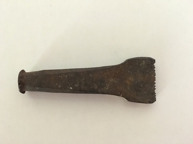
This is the stamp used by Ernest Phillips to mark his tools and his products. It was used both on wood and metal surfaces. Ernest Brighton Phillips (1875-1924) was born in Warrnambool and was apprenticed as a cabinet maker at the Warrnambool Box Works. By the 1890s he had established a furniture shop at the corner of Liebig and Koroit Streets and by the beginning of the 20th century he had the largest furniture warehouse and factory in Victoria outside of Melbourne. His products were sold all over Australia. He and his family lived at ‘Heatherlie’ in Koroit Street and today this site is occupied by the flats complex for senior citizens called ‘Heatherlie’. This stamp is of interest because it belonged to Ernest Phillips, a prominent Warrnambool businessman (late 1800s to the early 1900s.) It is also of interest as an example of an early name stamp. This is a small piece of metal with a rounded flange top and a wider flattened end. The end is serrated and cut to hold the letters, ‘E. Phillips’. Some white paint has been splashed on the end section.‘E.Phillips’ (letters reversed for stamping purposes)ernest phillips, history of warrnambool -
 National Wool Museum
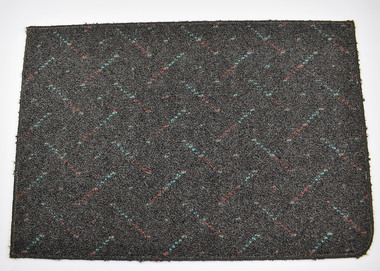
Carpet Samples, Godfrey Hirst and CO. Pty Ltd, c.1990
Carpet samples created by Godfrey Hirst, a carpet mill whose history spans back to 1865 when the Victorian Woollen and Cloth Manufacturing Company began operations in Geelong and was purchased in the 1890s by the man Godfrey Hirst. Godfrey Hirst’s entrepreneurial skills and knowledge of the industry led to the great success which saw the company expand in multiple forms over the next century and a half. Today, thousands of metres of carpet are produced by Godfrey Hirst every day, and their flooring can be found in millions of homes. These 6 carpet samples date from the early 1990s and each have a unique colour pattern and design.Each carpet sample is made with a pile fibre that is 100% wool. The primary backing of the carpet is a woven polypropylene with a secondary backing a woven jute. Carpet 8102.1's colour name is Slate. It has a dark grey background with a red and blue diagonal stripe. The pattern repeats in a 10cm x 11.5cm block. Carpet 8102.2’s colour name is Terracotta. It is a mostly block pink colour with no repeating pattern. It has occasional flicks of grey. Carpet 8102.3’s colour name is Arctic Night. It has white, light blue and grey colours repeating one after another in a diagonal line. Carpet 8102.4’s colour name is Ivory. It has a brown background with a cream colour diamond. The pattern repeats in a 15cm x 15cm block. Carpet 8102.5’s colour name is Glenwood. It has a thin darker green and lighter green horizontal stripe spanning its entire width. These stripes repeat the height of the carpet. Carpet 8105.6’s colour name is also Ivory. It has a brown background with a cream colour leaf pattern. The pattern repeats in a 92cm x 92cm block.Wording on rear: Numerous. See Media.godfrey hirst, carpet, textile manufacture -
 Kew Historical Society Inc
Plan, Melbourne & Metropolitan Board of Works : Borough of Kew : Detail Plan No.1576, 1904
The Melbourne and Metropolitan Board of Works (MMBW) plans were produced from the 1890s to the 1950s. They were crucial to the design and development of Melbourne's sewerage and drainage system. The plans, at a scale of 40 feet to 1 inch (1:480), provide a detailed historical record of Melbourne streetscapes and environmental features. Each plan covers one or two street blocks (roughly six streets), showing details of buildings, including garden layouts and ownership boundaries, and features such as laneways, drains, bridges, parks, municipal boundaries and other prominent landmarks as they existed at the time each plan was produced. (Source: State Library of Victoria)This plan forms part of a large group of MMBW plans and maps that was donated to the Society by the Mr Poulter, City Engineer of the City of Kew in 1989. Within this collection, thirty-five hand-coloured plans, backed with linen, are of statewide significance as they include annotations that provide details of construction materials used in buildings in the first decade of the 20th century as well as additional information about land ownership and usage. The copies in the Public Record Office Victoria and the State Library of Victoria are monochrome versions which do not denote building materials so that the maps in this collection are invaluable and unique tools for researchers and heritage consultants. A number of the plans are not held in the collection of the State Library of Victoria so they have the additional attribute of rarity.Original survey plan, issued by the MMBW to a contractor with responsibility for constructing sewers in the area identified on the plan within the Borough of Kew. The plan was at some stage hand-coloured, possibly by the contractor, but more likely by officers working in the Engineering Department of the Borough and later Town, then City of Kew. The hand-coloured sections of buildings on the plan were used to denote masonry or brick constructions (pink), weatherboard constructions (yellow), and public buildings (grey). Development in the 20th century has irreparably altered that part of Kew represented in this plan. In the block bounded by Cotham Road, Charles Street, Wellington Street and Gellibrand; just one house standing in 1903 remains. This block included two of the most historic houses in Kew: ‘Ordsall’ (later ‘Southesk’) and ‘Madford’ (previously ‘Elm Lodge’). Ordsall was the home of the second chairman of Kew, John Halfey. It contained some of the most significant interior murals in Kew, created for Halfey by artists working for Cullen & Co. It was demolished in 1960 to make way for the Kew Civic Centre. Elm Lodge had been built for William Siddeley in ca. 1864. Arthur Septimus King purchased it in 1874. The lower paddocks of Madford were sold in 1905 by his wife to the Borough of Kew and, after landscaping by George and Thomas Pockett, opened as the Alexandra Gardens in 1908. Elm Lodge/Madford was in 1922 to become St. Anthony’s Home for Little Children before its subsequent demolition in the 1980s.melbourne and metropolitan board of works, detail plans, maps - borough of kew, mmbw 1576, cartography -
 Kew Historical Society Inc
Plan, Borough of Kew Detail Plan No.1577, 1904
The Melbourne and Metropolitan Board of Works (MMBW) plans were produced from the 1890s to the 1950s. They were crucial to the design and development of Melbourne's sewerage and drainage system. The plans, at a scale of 40 feet to 1 inch (1:480), provide a detailed historical record of Melbourne streetscapes and environmental features. Each plan covers one or two street blocks (roughly six streets), showing details of buildings, including garden layouts and ownership boundaries, and features such as laneways, drains, bridges, parks, municipal boundaries and other prominent landmarks as they existed at the time each plan was produced. (Source: State Library of Victoria)This plan forms part of a large group of MMBW plans and maps that was donated to the Society by the Mr Poulter, City Engineer of the City of Kew in 1989. Within this collection, thirty-five hand-coloured plans, backed with linen, are of statewide significance as they include annotations that provide details of construction materials used in buildings in the first decade of the 20th century as well as additional information about land ownership and usage. The copies in the Public Record Office Victoria and the State Library of Victoria are monochrome versions which do not denote building materials so that the maps in this collection are invaluable and unique tools for researchers and heritage consultants. A number of the plans are not held in the collection of the State Library of Victoria so they have the additional attribute of rarity.Original survey plan, issued by the MMBW to a contractor with responsibility for constructing sewers in the area identified on the plan within the Borough of Kew. The plan was at some stage hand-coloured, possibly by the contractor, but more likely by officers working in the Engineering Department of the Borough and later Town, then City of Kew. The hand-coloured sections of buildings on the plan were used to denote masonry or brick constructions (pink), weatherboard constructions (yellow), and public buildings (grey). MMBW Plan No.1577 includes some of the most significant houses in Kew: Herbert Henty’s ‘Roxeth’ (now part of Trinity Grammar), ‘Butleigh Wooton’, ‘Bokara’ and ‘Harrow’. It also includes the streets that have since changed their names. That part of College Parade linked to Glenferrie Road is now named College Place, College Parade now extends further north, and Charles Street did not yet reach Barkers Road. Roxeth is one of a number of Henty houses in Kew. Herbert Henty made his home here and was elected a member of Kew Municipal Council in 1864 and mayor in 1868-69. Walter Henry Serle, of Harrow served in the First World War. He was awarded the Military Medal ‘’For conspicuous bravery and devotion to duty. On 29th September near BELLICOURT he showed the greatest bravery and determination when his platoon was attacked by enemy bombing parties. It was due largely to his personal efforts that all the attacks were repulsed. Until wounded, his utter disregard of personal safety and boldness in dealing with the attacks were the means of saving the situation and were an inspiring example to his men.’melbourne and metropolitan board of works, detail plans, maps - borough of kew, mmbw 1577, cartography -
 Kew Historical Society Inc
Plan, Melbourne & Metropolitan Board of Works : Borough of Kew : Detail Plan No.1578, 1904
The Melbourne and Metropolitan Board of Works (MMBW) plans were produced from the 1890s to the 1950s. They were crucial to the design and development of Melbourne's sewerage and drainage system. The plans, at a scale of 40 feet to 1 inch (1:480), provide a detailed historical record of Melbourne streetscapes and environmental features. Each plan covers one or two street blocks (roughly six streets), showing details of buildings, including garden layouts and ownership boundaries, and features such as laneways, drains, bridges, parks, municipal boundaries and other prominent landmarks as they existed at the time each plan was produced. (Source: State Library of Victoria). This plan forms part of a large group of MMBW plans and maps that was donated to the Society by the Mr Poulter, City Engineer of the City of Kew in 1989. Within this collection, thirty-five hand-coloured plans, backed with linen, are of statewide significance as they include annotations that provide details of construction materials used in buildings in the first decade of the 20th century as well as additional information about land ownership and usage. The copies in the Public Record Office Victoria and the State Library of Victoria are monochrome versions which do not denote building materials so that the maps in this collection are invaluable and unique tools for researchers and heritage consultants. A number of the plans are not held in the collection of the State Library of Victoria so they have the additional attribute of rarity.Original survey plan, issued by the MMBW to a contractor with responsibility for constructing sewers in the area identified on the plan within the Borough of Kew. The plan was at some stage hand-coloured, possibly by the contractor, but more likely by officers working in the Engineering Department of the Borough and later Town, then City of Kew. The hand-coloured sections of buildings on the plan were used to denote masonry or brick constructions (pink), weatherboard constructions (yellow), and public buildings (grey). MMBW Plan No.1578 is significant in that it defines the extent of two private schools: Xavier College and Kew High School (now part of Trinity Grammar) by 1904. In relation to the latter, the plan clarifies which buildings the High School operated from behind the mansion ‘Molina’. Established in 1902, Trinity Grammar was to later lease and subsequently buy Molina (now ‘Merritt House’) and ‘Elsinore’ (now ‘Roberts House’). Xavier College had been established in 1872. This 1904 plan delineates the West Wing and the Great Hall (built in 1890).melbourne and metropolitan board of works, detail plans, maps - borough of kew, mmbw 1578, cartography -
 Kew Historical Society Inc
Plan, Melbourne & Metropolitan Board of Works. Borough of Kew Detail Plan No.1579, 1904
The Melbourne and Metropolitan Board of Works (MMBW) plans were produced from the 1890s to the 1950s. They were crucial to the design and development of Melbourne's sewerage and drainage system. The plans, at a scale of 40 feet to 1 inch (1:480), provide a detailed historical record of Melbourne streetscapes and environmental features. Each plan covers one or two street blocks (roughly six streets), showing details of buildings, including garden layouts and ownership boundaries, and features such as laneways, drains, bridges, parks, municipal boundaries and other prominent landmarks as they existed at the time each plan was produced. (Source: State Library of Victoria). This plan forms part of a large group of MMBW plans and maps that was donated to the Society by the Mr Poulter, City Engineer of the City of Kew in 1989. Within this collection, thirty-five hand-coloured plans, backed with linen, are of statewide significance as they include annotations that provide details of construction materials used in buildings in the first decade of the 20th century as well as additional information about land ownership and usage. The copies in the Public Record Office Victoria and the State Library of Victoria are monochrome versions which do not denote building materials so that the maps in this collection are invaluable and unique tools for researchers and heritage consultants. A number of the plans are not held in the collection of the State Library of Victoria so they have the additional attribute of rarity.Original survey plan, issued by the MMBW to a contractor with responsibility for constructing sewers in the area identified on the plan within the Borough of Kew. The plan was at some stage hand-coloured, possibly by the contractor, but more likely by officers working in the Engineering Department of the Borough and later Town, then City of Kew. The hand-coloured sections of buildings on the plan were used to denote masonry or brick constructions (pink), weatherboard constructions (yellow), and public buildings (grey). While MMBW Plan No.1579 does not include many buildings, those that it does show are significant to Kew’s history. These include the ‘Kew [Railway] Station’ in Denmark Street and the ‘Recreation Hall’ and rear courts off Wellington Street. The plan shows the outline of the Recreation Hall, constructed in 1880, at the rear of which is listed a bowling green, two tennis courts, a ‘skittle alley’ and a pavilion. When the Hall was first built, the Kew Cricket Club occupied an adjacent ground, however in 1885 this was acquired by the State Government as the future location of the Kew Railway Station. The Plan also shows a single oval at Xavier College. This oval was completed in 1883. One of the current ovals conforms to this oval’s original shape and position in the school grounds.melbourne and metropolitan board of works, detail plans, maps - borough of kew, mmbw 1579, cartography