Showing 1556 items
matching storey
-
 Bendigo Historical Society Inc.
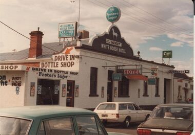
Photograph - BENDIGO HOTEL COLLECTION: WHITE HORSE HOTEL
Colour image: 'White Horse Hotel', Eaglehawk Road, California Gully. Single storey building, ornate, white façade, brown painted pediment with 'White Horse Hotel' in white paint. 'Wright' printed above hotel name (could be publican's name). Image of horse in white above name of hotel. LH side of image shows later addition, flat roofed 'bottle shop'.bendigo, hotel, white horse hotel -
 Kew Historical Society Inc
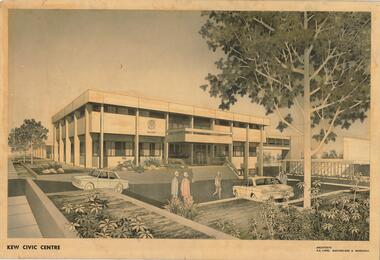
Drawing, AK Lines, Macfarlane & Marshall, Kew Civic Centre, c.1970
The Kew Civic Centre (A K Lines, MacFarlane & Marshall, 1972) was built next to the Kew Civic Hall (A C Leith & Bartlett, 1960) on the site of the former mansion Ordsall (later renamed South Esk). Whereas the entrance to the Civic Hall was positioned off Civic Drive, the main entrance to the Civic Centre faced Cotham Road, as shown in the undated perspective drawing of the proposed building. The Civic Hall was used for public functions and performances, while the Civic Centre was used for civic offices. It also contained the Council Chamber. The building opened in 1972, following the relocation of the councillors and council officers from the former Town Hall in Walpole Street (now a Woolworth's supermarket). Following the amalgamation of the former City of Kew into the City of Boroondara in 1994, the Civic Centre was sold to Trinity Grammar School. The exterior of the Centre has been modified by Trinity Grammar.A report for Heritage Victoria (date) describes how two architectural firms dominated the designs for new civic buildings in Victoria during the post war period. The report claims that: "An interesting sub-theme in the erection of post-war municipal offices in Victoria is that a considerable proportion were designed by the same three or four Melbourne-based architectural firms, who established themselves as the leading specialists in this type of work. The two most prolific firms in this regard were A K Lines, MacFarlane & Marshall, and A C Leith & Bartlett; both, in fact, had made names for themselves as designers of local government offices prior to the Second World War. Lines' office, for example had designed the Eltham Shire Offices in 1941, while Leith's firm had been responsible for the celebrated Heidelberg Town Hall in 1937). Both practices parleyed this early experience into a lucrative post-war career, designing numerous municipals offices well into the 1970s." (Survey of Post-War Built Heritage in Victoria, Built Heritage Pty Ltd, 2010.) The perspective drawing importantly captures the original design and function of the exterior of the building and its public entrance.Hand-coloured perspective sketch of the new Kew Civic Centre, completed in 1972 to designs by A K Lines, MacFarlane & Marshall; and located on the corner of Charles Street and Cotham Road, Kew. The sketch represents the front elevation of the building and its relation to the preexisting Kew Civic Hall at right. The three storey building features strong vertical concrete buttresses that extend across the three levels. KEW CIVIC CENTRE / A K LINES, MACFARLANE & MARSHALLkew civic centre, a.k. lines, macfarlane & marshall, architectural drawings, civic buildings -- kew (vic.), town hall -- kew (vic) -
 Kew Historical Society Inc
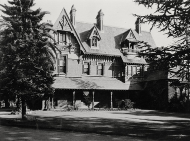
Photograph - 'Tara Hall', Studley Park Road, Marc Strizic (attrib), c.1960
'Lost Glories: a memorial to forgotten Australian buildings' was published by David Latta in 1986. It tells the story of a number of significant Australian buildings that had previously been demolished. A chapter in the book was devoted to Goathland, later known as Tara Hall. To supplement the text, he sourced photographs from a range of suppliers, chiefly the Royal Women's Hospital which had once owned Tara Hall, but had sold it in 1960. This is one of the photographs donated to KHS by the author.Tara Hall, Studley Park Road, circa 1957. The front of Tara Hall (previously named Byram, Goathland and Lowan). This triple-storey mansion with its elaborate gabled, steeply-pitched roofs and verandah was set back from Studley Park Road and concealed by a high brick fence. E. G. Kilburn, of Ellerker & Kilburn, designed Byram for the industrialist George Ramsden in 1888. Typed inscription on reverse: "Tara Hall at the time it was a home for nurses from the Royal Women's Hospital, Melbourne. (Royal Women's Hospital, Melbourne)."byram, goathland, tara hall, lowan, studley park (kew), george ramsden, sir malcolm mceacharn, edward george kilburn (architect), studley park road (kew) -
 Kew Historical Society Inc
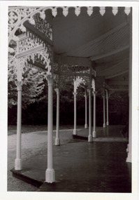
Photograph - Verandah of 'Wimba', 235 Cotham Road, John T Collins, 1979
Although probably built some time earlier, the first mention in the Rate Books of the property later known as 'Wimba Lodge' appears in the entry for 1870 when the property, owned by John Sharpe Denbigh, a civil servant, was given an N.A.V. of £72. Denbigh did however occupy a house in Cotham Road in 1863, and it is possible that was the same premises'. The house was occupied by Sharp until at least May 1876 when the 'family residence ... was auctioned' to Carlington George Edmund Marston, a chemist of Smith Street, Collingwood. At the time of the auction the house was described thus: The residence and grounds of the late J.S. Dendigh, situate in the most elevated part of Cotham Road Kew. The grounds comprise an area of 4a Or 29p or thereabouts, and have a frontage to Cotham-road of 4 chains. The house has two large rooms in front, with 6ft hall built of brick, bay and side windows (plate glass), four rooms of wood behind with slate roofs, bathroom and closets, detached kitchen and servant's room, large shed with washing boiler, pantry and cellar under, brick and cement tank, and the Yan Yean laid onto house and grounds, cowshed, pigstye, &c, the whole securely fenced. First class orchard and flower garden. The paddocks laid with English grasses and drained... .' (Sanderson P. Kew Conservation Study Vol 2)'Wimba' is a single storeyed rendered house. The front entrance is flanked by two polygonal bay windows, and a verandah with a concave corrugated iron roof returns around three facades, and accentuates the projections of the windows. The solid render parapet is very ornate and tall for the date of construction. It has panels of decoration along it and is surmounted by a number of render urns. (Sanderson P. Kew Conservation Study Vol 2)Reverse: "JOHN COLLINS / 11 Anderson Road / Hawthorn East, 3123 / Film 395 Exposure 15A / Kew / Wimba / Front verandah from east / 7-4-79wimba lodge, 235 cotham road -- kew (vic.), john s denbigh, carlington george edmund marston -
 Surrey Hills Historical Society Collection
Photograph, Sunbury Crescent, Surrey Hills looking towards the corner of Union Road, 1930s, 1930
Date is approximate. This is one of a series of photos donated by Arthur Lyons. Lyons family history: Arthur's father, Fred Lyons initially worked for George Rea's cab service until he set up his own business. He started with a horse and hansom cab but in time he changed over to a motor vehicle and continued his service until 1960. Frederick Adolphus Lyons (1891-1980) was born in Surrey Hills, son of Thomas and Catherine Lyons. He married Elizabeth Ruby Hall in 1918. They lived at 55 Sunbury Crescent. The Lyons’ home in Sunbury Crescent was called ‘Knopshambury’ - this was probably a misspelling of Knockshanbally in Co Kilkenny, the birth place of Fred’s father, Thomas Edmund Josias Lyons (1846-1915). Arthur Lyons was born in Surrey Hills on 12 Jun 1920. He became a motor mechanic / welder and lived his whole life at 55 Sunbury Crescent. The donation was made while he was in hospital. He died shortly afterwards (23 Sep 1990). Donation was finalised by a neighbour, Mrs Florence Ann Armitstead, wife of Glen Victor Armitstead. Glen was a local hairdresser. They moved to 11 Sunbury Crescent after their marriage in 1939. Arthur had no relatives to distribute the material to. The buildings date from circa 1887 and extended some way down Sunbury Crescent. The address was 63 Sunbury Crescent on the corner of Union Road. Built by Albert Mills for the Premier Land Agency; taken over by Timothy Leigh in 1893. The building housed a variety of shops – initially the land agency, but later shops included at various times a fruiterer, florist, carpenter, fishmonger, upholsterer, plumber. However, by the time this photo was taken in the 1930s it was occupied by Triumph Press. The printing industry continued to have a lasting presence. Triumph Press was followed by Surrey Press and in 1970 New Life Publications moved to the site from Abbotsford. It was about this time that this original building was demolished to make way for a modern print works. Gradually the needs of the printing business absorbed other properties along the Union Road frontage. The boy in the photo is Arthur (Tiger) Lyons and beside him is Alf Johnson, the local printer. The Lyons family lived adjacent to these buildings at 55 Sunbury Crescent.Black and white photo of a section of double-storey terrace buildings in Sunbury Crescent Surrey Hills, taken looking towards the corner of Union Road. The bricks are two-toned and laid in herringbone pattern. The verandah on the 2nd story is filled in with cast-iron lacework panels. There are 2 vintage cars in front of the terrace. A young boy sits on the running board beside a man dressed in suit and hat. printers, vintage cars, sunbury crescent, victorian style, union road shops, arthur lyons, arthur frederick lyons, alf johnson, triumph press, surrey press, new life publications, timothy leigh,, albert mills -
 Surrey Hills Historical Society Collection
Photograph, 181 Union Road, home of Mr and Mrs Antonio Clota
The house was built in 1910. The Clota and Sans families were part of a group of families of Spanish (Catalan) background who lived around Surrey Hills, many of whom are buried in Box Hill Cemetery. The house was built for Antonio and Josepha Clota and passed on to their daughter Josephine Sans and her family. Antonio's full name: Antonio Eusebio Miquel CLota (1869-1940; died Surrey Hills) had 3 brothers who came to Australia with him. Louis Clota (1864-1925); Marcus Clota (1866-1940) died Surrey Hills; Eusebio Clota (1869-1919). Their parents remained in Spain. Josephine Clota and Kim Sans had photos taken on the front entrance to the house when they were married on 9 May 1919. The wedding was reported in Punch.Black and white photo of the home of Mr and Mrs Antonio Clota; later the home of their daughter Josephine and son-in-law, Kim Sans and family. It shows bluestone curb and channelling in Union Road and a substantial wire mesh fence. The street tree looks like a plane tree and is a relatively young plant. Ther house is single storey brick with a tile roof and solid pillars supporting the verandah.houses, antonio clota, josepha comellas, josepha clota, catalan families, josephine clota, josephine sans, kim sans, joaquim sans, francis clota, frank clota, box hill cemetery -
 Surrey Hills Historical Society Collection
Photograph, Armitstead Woodyard truck decorated for Empire Day, mid-1930s, 1930
Date is approximate. Donor's connection with Armitstead's Woodyard was that Frank Foley was a long term employee. The Empire Day movement was instituted in England in 1904 and on 24 May 1906 a group of Surrey Hills residents pledged to make Empire Day a success. From 1932-1938 large Empire Day celebrations were held in Surrey Hills and business and commercial vehicles were decorated to take part in large processions held in May each year. These attracted large crowds from all over Melbourne. The truck is parked outside Nethercourt Hospital at 15 Barton Street. The Armitstead family had a business in Union Road which supplied wood in winter and ice in summer. Photos such as this one are evidence of the importance once attached to celebrating Empire Day, which was held on 24 May (Queen Victoria’s birthday). From 1905, a range of patriotic activities across Australia were performed on this day. There was a focus on schoolchildren, who were given a half-holiday, and the occasion was often highlighted with bonfires and fireworks in the evening - in this area at Beckett Park. The parade down Union Road was famous throughout Melbourne and attracted large crowds. Floats in the parade were often decked with British flags. The pro-Empire sentiment in the Surrey Hills area in part reflected the background and strong ties of many families.Black and white photo of a delivery truck with bunting and ferns over the cabin and back. The wheels have straws around the rims and more foliage is on the cabin roof and bonnet. The back of the tray is up and boxes, foliage and possibly a lion's head decorate the tray. Behind is a 2 storey (?) rendered building with an external timber staircase broken in 2 by a landing. The house sits behind a simple picket fence.On the cabin door of the truck: "S ARMITS ....[remainder in shadow] / Surrey Hills / phone 10X1816 / [undecipherable]" On back of the original in pencil in top centre left "446a" in Jocelyn Hall's handwriting; centre on a piece of paper stuck on with tape "Mrs D Foley / 39 Sunbury Cres., / Surrey Hills / Phone 8301163".empire day, festival and celebrations, woodyard, parades, processions, hospitals, nethercourt hospital, stephen godfrey armitstead, frank foley, mrs d foley, barton street -
 Charlton Golden Grains Museum Inc
Photograph, Charlton Post Office 1987, c.1987
First Post Office established in Camp St in 1878. Rebuilt on current site in 1879, current Post Office built 1940. Photo part of a Charlton Shire streetscape series 1987.Colour photo of Charlton Post Office. Red brick single storey building. Clock above entrance shows 5 minutes to nine. Yellow combi van, tree and public telephone on LH side of photo. Street light and rubbish bin on right of entrance. Signage above entrance says Post Office Charlton, ER and crown above the clock. Brown fence to right of building,charlton post office, charlton, business, industry, post office -
 Charlton Golden Grains Museum Inc
Photograph, Charlton Shire, Charlton Motel c. 1987, c.1987
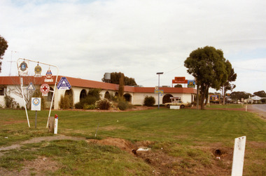
The motel was built in the 1960s. Photo is part of a Charlton Shire streetscape series c.1987.Colour photograph of the Charlton Motel taken looking south east. The Motel is a white brick, single-storey building with a red trimmed roof. The verandah and some front windows are arches. There is a large garden bed with shrubs in front of the verandah. On the left are signs for various community organisations - Lions, Rotary, Apex, Young Farmers, Red Cross, and Amity. A cream coloured car is parked in the drive way business, charlton, motel -
 Bacchus Marsh & District Historical Society
Photograph, Group of men with rifles Bacchus Marsh 1883
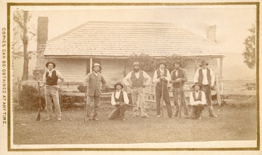
This image is one of several family or group portraits taken by the photographers Stevenson and McNicoll in Bacchus Marsh and nearby districts in 1883. The identity of this group and the location where the image was taken has not been identified. The presence of the guns in the picture suggests it might have been a group of men who gathered together as part of a shooting or hunting group. They may also have been members of Bacchus Marsh Rifle Club which was already in existence when this photograph was taken in 1883.Small sepia unframed photograph on card with gold border framing photograph. Housed in the album, 'Photographs of Bacchus Marsh and District in 1883 by Stevenson and McNicoll'. The image shows a group of eight men in front of a house. Five of the men are holding rifles. Six of the men are standing. Two are squatting. They are in front of a single storey timber house. The house has a shingled roof and two chimneys and a front verandah. On the front: Stevenson & McNicoll. Photo. 108 Elizabeth St. Melbourne. COPIES CAN BE OBTAINED AT ANY TIME. On the back: LIGHT & TRUTH inscribed on a banner surmounted by a representation of the rising sun. Copies of this Portrait can be had at any time by sending the Name and Post Office Money Order or Stamps for the amount of order to STEVENSON & McNICOLL LATE BENSON & STEVENSON, Photographers. 108 Elizabeth Street, MELBOURNE. stevenson and mcnicoll 1883 photographs of bacchus marsh and district, shooting, firearms -
 Bacchus Marsh & District Historical Society
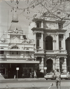
Photograph, Main Street Bacchus Marsh 1883 looking east
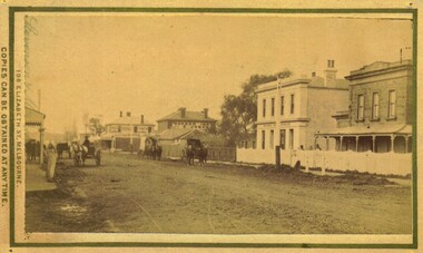
View of Main Street Bacchus Marsh 1883, showing early notable buildings on the southern side of the street, including the Courthouse, National Bank of Australasia, Border Inn, Hall of Commerce building. Small sepia unframed photograph on card with gold border framing photograph. Housed in the album, 'Photographs of Bacchus Marsh and District in 1883 by Stevenson and McNicoll'. Several horse-drawn vehicles can be seen travelling along an unmade road. Piles of excavated dirt can be seen along the side of the road. Four substantial two-storeyed buildings can be seen along the southern side of the street.On the front: Stevenson & McNicoll. Photo. 108 Elizabeth St. Melbourne. COPIES CAN BE OBTAINED AT ANY TIME. On the back: LIGHT & TRUTH inscribed on a banner surmounted by a representation of the rising sun. Copies of this Portrait can be had at any time by sending the Name and Post Office Money Order or Stamps for the amount of order to STEVENSON & McNICOLL LATE BENSON & STEVENSON, Photographers. 108 Elizabeth Street, MELBOURNE. stevenson and mcnicoll 1883 photographs of bacchus marsh and district, bacchus marsh roads and streets, bacchus marsh main street 19th century -
 Lakes Entrance Historical Society
Photograph - Housing, 1990
Moved to present site 1989c by Tony TrompColour photograph of a single storey timber dwelling with corrugated iron hipped roof, bay window at front room, veranda on two sides, unique sunshade over SW window, internal chimneys with chimney pots. Set in bushland with native plant garden, at 357 Lake Tyers Beach Road. Painted cream with fawn trim. Relocated from Esplanade. Lake Tyers Beach Victoriahouses, architecture -
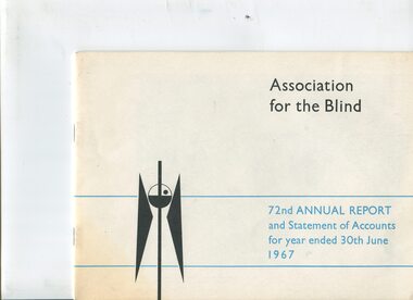 Vision Australia
Administrative record - Text, 72nd Annual Report 1967 Association for the Blind of Victoria, 1968
Articles in annual report include: President's report, objectives, finance report, accounts, hospital homes, community centre, accommodation, future programme, welfare, auxiliaries, life governors, public appeal, the death of Granny Carson aged 104, the successful introduction of a Homemakers Club and Creche at the Blind Community Centre, as well as Braille teachers from the Braille Writing Association, and that financial assistance for a two storey wing to be added to the Brighton Hospital Home.1 volume of text with illustrations and photographsassociation for the blind, sir rohan delacombe, h.m. lightfoot, p. fretton, annual reports -
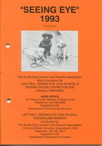 Vision Australia
Administrative record - Text, "Seeing Eye" 1993 Lady Nell "Seeing Eye" Dog School & Rehabilitation Centre for the Blind, 1993
President's overview of the year including: the replacement of an older house with a 2 storey building at 12 Thanet Street, continued success of the St Leeor Nursing Home under director Anita Henley, need for permanent and temporary accommodation as offered by the hostel at 2 Derril Avenue, popularity of Day Activity Centre, loss of Adeline Levinson, thanks to Jan McCall and Dr Tony Mason, appeal for volunteers and opportunities for speaking engagements, and profile of Phyllis Gration.1 volume with text and illustrationsannual reports, lady nell seeing eye dog school, phyllis gration -
 Glenelg Shire Council Cultural Collection
Photograph - Photograph - 'Stanton Drew', Portland, n.d
Stanton Drew was a two storey stucco rendered bluestone house was constructed in 1864 for Major Alexander Davidson, a Scottish born pastoralist who had earlier in 1848 settled on the Wando River near Casterton. Stanton Drew is a characteristic pattern book, regency gothic villa and virtually devoid of ornamentation save for unusually fenestrated bay windows and window label mouldings. Stanton Drew is a late example in Victoria of the primitive regency gothic style of villa architecture popularised by pattern books of the period 1840-60. The two storey house is an undistinguished design most notable for its associations with Western District pastoralist Alexander Davidson. No important historical associations are apparent, although the Davidson family lived in the residence until c.1908. Stanton Drew is in an extremely dilapidated state and has suffered badly form subsidence and lack of regular maintenance. The slate roof has been replaced with iron. The house was originally named Wando Villa by Davidson in memory of his time at Wando River. The house was renamed in 1938.Black and white photo. View of the front of 'Stanton-Drew' house, Portland.Back: 'STANTON-DREW, PORTLAND, VICTORIA, 1971' -handwritten black biro. Purple stamp 'ALEX PRIESTLEY BOX 155 PHONE 309 HEYWOOD VIC 3304'historic homestead, bluestone building, alexander davidson, pastoralist -
 Kew Historical Society Inc
Slide - House, cnr Fellows and Barry Streets, 1979
One of a group of slides taken by members of the Society of built heritage in Kew in 1979-80. The selection of subject matter reflects the priorities of the period. The colour of some slides has degraded. This particular slide is of 'Fairholme' on the corner of Barry and Fellows Street. The building is listed by the National Trust (Victoria). The citation on the Historic Buildings Register states: 'Fairholme is of State architectural significance as a distinctive free Romanesque Revival residence. Built in two stages, 1889 for solicitor Edward Smart and early this century for importer, J K Meritt, the singular architectural character of Fairholme is achieved by combining window bays and groups of windows with a two-storey gabled porch. The deliberate and distinctively asymmetrical composition is emphasised by Art Nouveau pressed cement detailing (coprosma) on a bowed balcony and the two-storey timber verandah, which is typical of the Edwardian period. The architects were Reed, Henderson & Smart (1889) and C Gordon McCrae (c 1900-1). Internally a grand entry hall with inglenook, staircase and gallery follow the Arts and Crafts quality of the exterior. Classified: 17/03/1993'The slides represent a snapshot in time of built architecture in Kew, much of which has changed in the forty-plus period since they were created. 35mm colour transparency (slide) of 'Fairholme' (1889) on the north-east corner of the intersection of Fellows and Barry Streets, Kew. The photo was developed in May 1979.barry street -- kew (vic.), fellows street -- kew (vic.), historic houses -- kew (vic.), architects -- reed henderson & smart, architectural styles -- romanesque revival, j k merritt -
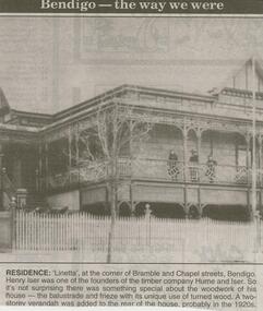 Bendigo Historical Society Inc.
Newspaper - JENNY FOLEY COLLECTION: RESIDENCE
Bendigo Advertiser ''The way we were'' from 2000. Residence: 'Linetta', at the corner of Bramble and Chapel streets, Bendigo. Henry Iser was one of the founders of the timber company Hume and Iser. So it's not surprising there was something special about the woodwork of his house - the balustrade and frieze with its unique use of turned wood. A two-storey verandah was added to the rear of the house, probably in the 1920s. The clip is in a folder.newspaper, bendigo advertiser, the way we were -
 Bendigo Historical Society Inc.
Photograph - BENDIGO ARCADE, 1970's ?
black and white photograph,. Entrance from Pall Mall of 'Bendigo Arcade' and former Colonial Bank, later National Bank ( J. Lerk, 10th. March, 2000 ) National Bank, sign over entrance, finials to pressed steel roof. Moulding decorates upper storey windows and balcony. National bank with cast urns to roof. Valiant sedan car on left. Holden on right. Parking meters on footpath.organization, business, bendigo arcade -
 Bendigo Historical Society Inc.
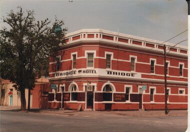
Photograph - BENDIGO HOTEL COLLECTION: BRIDGE HOTEL, BRIDGE STREET, BENDIGO
Colour photograph: Bridge Hotel,Bridge Street, Cnr Cemetery Street, Bendigo. Two storey red brick hotel, no verandah. White trim around windows and across top pediment. Large tree on LH side of image. Formerly called the Hibernia. Sign out front 'Chinese Meals' Hotel situated next door to Bendigo Chinese Association rooms, just visible on LH side of image.bendigo, hotel, bridge hotel -
 Kew Historical Society Inc
Photograph - Victorian Canoe Club, V.C.C. Studley Park, 1920-30
Canoeing on the River Yarra at Melbourne was an important and widespread recreational pursuit for Melbournians, especially in the first half of the twentieth century. The Victorian Canoe Club was formed in 1912 at a meeting in Melbourne and its first committee elected in the same year. Records indicate that the Club continued into at least the 1950s .The album has historic and social significance as a record of recreational activities (as well as canoe making) in the early years of the twentieth century. It has local significance as the site of the headquarters of the Club was in Studley park. A number of photographs in the album provide vistas of Kew on the Yarra that are otherwise unavailable.One of 24 labelled photos in part album, originating from the Victorian Canoe Club, which had its headquarters in Studley Park, Kew. The album includes a photographic record of canoe construction and also locations in Studley Park and Kew where the canoes were used. The subject of this photograph is identified as 'V.C.C. Studley Park' with its single storey weatherboard club house on the banks of the Yarra River."V.C.C. Studley Park"victorian canoe club, river yarra, studley park, boat houses, canoe clubs -
 Charlton Golden Grains Museum Inc
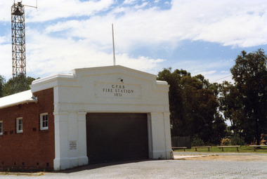
Photograph, Charlton Shire, Charlton Fire Station c. 1987, c.1987
The Charlton Fire Station was built in 1931.Colour photograph of the Charlton Fire Station. A single storey red brick building with a white frontage. A large entrance and three high high windows down the side. There is a plaque on the LH side of the main entrance that can't be clearly read.. The signage above the main entrance reads C.F.B.B. FIRE STATION 1931 There is a light above this sign. The fire tower is at the rear of the building. There is a low railing fence on the right side.charlton fire station, charlton fire brigade, public services -
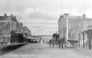 Surrey Hills Historical Society Collection
Work on paper - Photograph, Canterbury Road, near the corner of Union Road, 1911
J A Geer's grocery store operated from 1909-1912 on the site established by George Sim in 1884. He bought a house and added a shop where, in 1889, he established the first post office in the area. Prior to this residents had to go the Box Hill to collect mail. Date is approximate.This records one of the earliest businesses in Surrey Hills. To begin with, businesses developed along Canterbury Road rather than Union Road, in part because of the muddy nature of the land north of the railway line.Black and white photo taken from a postcard of Canterbury Road, near the corner of Union Road, looking west in 1906 or 1907. Two children play on the LHS of the street and there is a man on a horse and carriage, and a cart, on the RHS. Buildings on the RHS are the Surrey Family Hotel and J A Geer's grocery store; on the LHS is a row of double-storey terraces including Hansen's Terrace on Canterbury Road to the west of Union Road.On LHS within the original image is 'Canterbury Road, Surrey Hills'; on the rear in top LH corner in blue biro in Jocelyn Hall's handwriting "J H / spare"canterbury road, geer's grocery store, surrey family hotel, businesses, horse drawn vehicle, hansen's terrace, post card, mr j a geer -
 Bendigo Historical Society Inc.
Memorabilia - JOHN WILLIAMS COLLECTION: WOODEN MODEL OF BENDIGO HOSPITAL CIRCA 1950'S
Wooden model, painted white with brown roof. Model depicts the old Bendigo Hospital, Lucan Street , Bendigo in 1950's. Written on bottom on wooden 'icypole stick' "Bendigo Hospital 1956 era." Model is 2 storey, with central, tall rectangular entry and flagpole on top. Original Hospital was demolished in 1989. Listing and Statement of Significance on Heritage Victoria data base ( see historical details field )bendigo, buildings, old bendigo base hospital, lucan street, heritage victoria database -
 Eltham District Historical Society Inc
Document - Property Binder, 1151 Main Road, Eltham
Newspaper article: Units vote sparks row, Diamond Valley News, 8 April 1998, Nillumbik Council meeting discussed application for 7 double-storey attached units development at block from 1151 Main Road to Railway Road. Newspaper article: Units go-ahead as decision reversed, Diamond Valley News, 29 April 1998, Nillumbik Council discussed proposed developments at 1151 Main Road and 30 Swan Street. main road, eltham, property, houses, natalie woodley, robert marshall, marg jennings, john graves, lex de man, 30 swan street eltham, railway road eltham -
 Eltham District Historical Society Inc
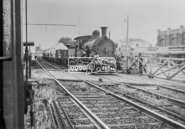
Photograph, George Coop, Copy of a photo of Steam locomotive Y-103 at Newport Railway Station, c.1951, 1962
The Melbourne Road level crossing is now the location of the pedestrian underpass. Hall Street is seen to the right and the two-storey brick building remains to present day One of several photos at Newport taken the same day in the early 1950s when George Coop was a secondary school student. This photo is a 35mm copy (1962) of an original print of the c.1951 negative - possibly to use up the last frame after photographing several other early VR prints.Digital TIFF file Scan of 35mm Ilford FP3 black and white transparencygeorge coop collection, hall street, level crossing, melbourne road, newport railway station, y-103, y-class steam locomotive -
 Eltham District Historical Society Inc
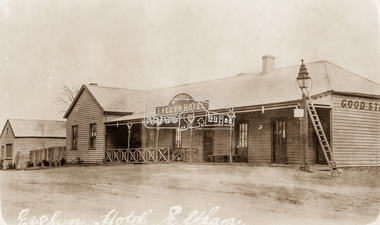
Photograph, Evelyn Hotel, Eltham, c.1911
Postcard image of W. Morris Evelyn Hotel, cnr. Main Road and Pitt Street, Eltham, opposite present hotel. This image is post the 1910 fire which damaged the southern two-storey section. It was rebuilt as single story. The hotel was delicensed in 1919 and became a Dining Room then a boarding house. It was destroyed by fire in the summer of 1931 when at the time it was occupied solely by the McLean family, Hector and Louisa McLean who had five young daughters at the time.Postcard photoRetun to Garnet Burges c/o Judge Bookhotels, evelyn hotel, eltham, main road, pitt street, fountain hotel, william morris -
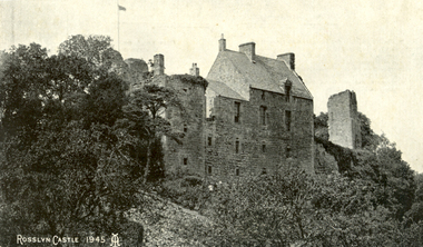 Federation University Historical Collection
Postcard, Roslin, c1945
Roslin Castle, the seat of the St Clair Family, was founded in 1304. It is partly in ruins. According to legend some millions of pounds worth of treasure being hidden in the vaults. it is said to be under the charge of a lady of the ancient St Clair family. She is to wake from her slumber and point out the spot where the treasure lies. It is located near the village of Roslin in Midlothian, Scotland. It is located around 9 miles south of Edinburgh, on the north bank of the North Esk, only a few hundred metres from the famous Rosslyn Chapel. (See http://en.wikipedia.org/wiki/Roslin_Castle)Three postcards showing different views of Roslin Castle. .1) A stone building on a hill side, with flying flag, .2) The Courtyard, Roslin Castle .3) The Bakehouse, Roslin Castle.1) This a fine view taken from the Glen. Formerly the castle was eight storeys high, five above and three underground. .2) While at Edinburgh I went out to Roslin saw there the Castle and Church. They are both very old dating back 500 hundred years. .3) The hole in the wall is the oven, is an immense thing. A fire was lit in the oven then pulled out and the heat in the stone did the baking.roslin, rosslyn, roslin castle, st clair, spirit, ghost, baking, oven, bread -
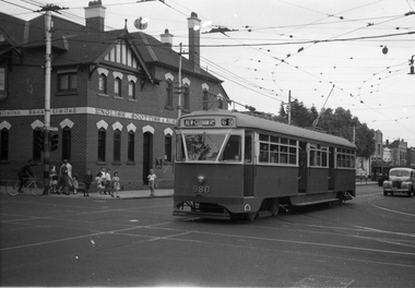 Melbourne Tram Museum
Negative, Wal Jack, 9/02/1951 12:00:00 AM
Black and white negative, by Wal Jack, of PCC 980, northbound bound in Glenferrie Road at High Street with the destination of Kew Cotham Road. The Bank was replaced by a more modern looking building during the 1970's. In the background is the ES&A bank on the corner. Jane Nigro advised 9/9/2020: "1907 Photo of the E. S. & A. Bank on the corner of High Street and Glenferrie Road, Malvern. In 1885 land on corner of Glenferrie Road & High St. (40' x 150') was purchased by E.S. & A. Bank. A condition of sale was that the bank erect on the land a 'substantial brick building to be used as a branch bank', within 24 months. The E.S. & A. Bank, single-storey four roomed brick, was built in 1888. The first manager was Frederick Leonard. In 1907 a second storey, including residential quarters for the manager, was added to bank at a cost of £1400.The Bank was demolished in 1958-9and replaced with present building."trams, tramways, pcc class, glenferrie road, route 69, kew- cotham rd, tram 980 -
Phillip Island and District Historical Society Inc.
Photograph, 1876
Left of photograph Bergin & Co, Griffiths Point Store in very large lettering. Residence above store, four open windows. Woman in white blouse and long black skirt entering one of two doors. The weatherboard building right on street. Next door San Remo Hotel. Bar entry on left. Large window on brick wall. Weatherboard upper storey with verandah and elaborate pillars wrought iron work and big turret attic towards back.Beautiful blown-up picture of the store and hotel side by side. Store open for business. Lady enteringlocal history, photography, photographs, slides, film, griffiths point store, san remo hotel, black & white photograph, miss elms san remo -
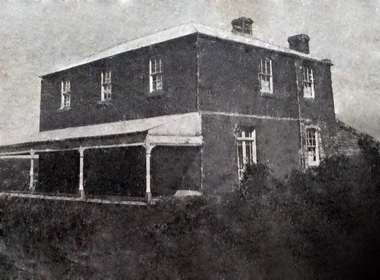 Torquay and District Historical Society
Photograph (copy), Bellbrae Cemetery Memorial Exhibition 2015
Photograph shows Llanberris House, built by Joseph and Mary Gundry on Iron Bark Station, west of the Anglesea Geelong Road, off Menzels Road above Spring Creek. The Gundrys took up Iron Bark station in 1844 and subsequently bought up more surrounding land. Just prior to Joseph's death in 1878, the property comprising 7721 acres was offered for sale as well as conditional rights to adjoining land. Llanberis House was a substantial stone dwelling of 2 storeys with 11 rooms.The Gundry family was one of the pioneering European settlers in the Bellbrae Torquay area.Black and white photographbellbrae victoria pioneer families