Showing 112671 items
matching tracks/roads
-
 Eltham District Historical Society Inc
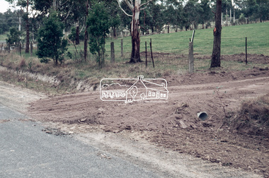
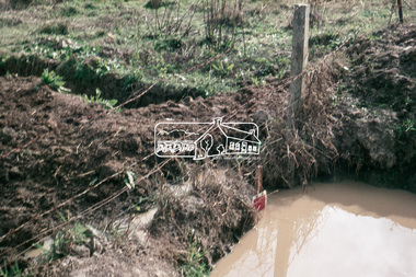
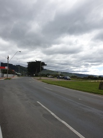
Slide, Post drainage repairs on Bonds Road near Martin property and Montpelier Drive, Lower Plenty, c.July 1972, 1972
Water drainage work undertaken by Eltham Shire Council in Bonds Road, Lower Plenty outside the Martin property opposite Montpelier Drive, July 1972 35 mm colour positive transparency Mount - Agfacolor Service (Blue)Bonds Road (Martin property) 12.10 pm 18.7.72bonds road, drainage works, eltham shire council, infrastructure, lower plenty, martin property, montpelier drive -
 Eltham District Historical Society Inc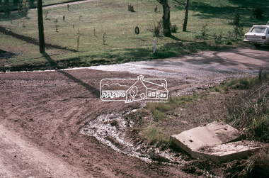
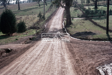
Slide, Looking north post drainage repairs on Bonds Road near Martin property and Montpelier Drive, Lower Plenty, c.July 1972, 1972
Water drainage work undertaken by Eltham Shire Council in Bonds Road, Lower Plenty outside the Martin property opposite Montpelier Drive, July 1972 35 mm colour positive transparency Mount - Agfacolor Service (Blue)Bonds Road (Martin property) 12.10 pm 18.7.72bonds road, drainage works, eltham shire council, infrastructure, lower plenty, martin property, montpelier drive -
 Eltham District Historical Society Inc
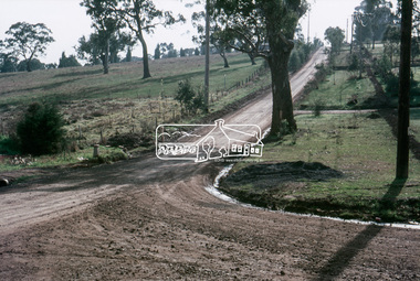
Slide, Post drainage repairs on Bonds Road near Martin property and Montpelier Drive, Lower Plenty, c.July 1972, 1972
Water drainage work undertaken by Eltham Shire Council in Bonds Road, Lower Plenty outside the Martin property opposite Montpelier Drive, July 1972 35 mm colour positive transparency Mount - Agfacolor Service (Blue)Bonds Road (Martin property) 12.10 pm 18.7.72bonds road, drainage works, eltham shire council, infrastructure, lower plenty, martin property, montpelier drive -
 Eltham District Historical Society Inc
Slide, Post drainage repairs on Bonds Road near Martin property and Montpelier Drive, Lower Plenty, c.July 1972, 1972
Water drainage work undertaken by Eltham Shire Council in Bonds Road, Lower Plenty outside the Martin property opposite Montpelier Drive, July 1972 35 mm colour positive transparency Mount - Agfacolor Service (Blue)Bonds Road (Martin property) 12.10 pm 18.7.72bonds road, drainage works, eltham shire council, infrastructure, lower plenty, martin property, montpelier drive -
 City of Kingston
Pamphlet - Colour, Stillwell and Co, The Hill Estate Highett Great Subdivisional Auction Sale, 1917
Sales plan for land in the suburb of Highett, bounded by Point Nepean Road and incorporating Sandford Street, Turner Road, Alfred Street, Peace Street and Tennyson Street. .The developing urban area of Highett within the City of Kingston. This land sale pamphlet illustrates the subdivision of land within the municipality and the changing demographic of the district as new houses are constructed.Colour pamphlet advertising subdivisional auction sale of the Hill Estate Highett. Incorporates a map of the estate bordered by Point Nepean Road and encompassing Sandford Street, Turner Road, Alfred Street, Peace Street and Tennyson St. Handwritten in grey pencil on reverse: Hill Street / Jamieson Handwritten in blue pencil on reverse: The Hill Estate Handwritten in blue pencil on subdivision map: [tick] [on majority of properties marked on map]highett, land sales, estate -
 City of Kingston
Pamphlet - Colour, W. H. Wood Estate Agent, Realising sub-divisional auction sale Bentleigh Park Estate, Bentleigh, 1920
Sales plan for land in the suburb of Bentleigh, bounded by Centre Road, and incorporating subdivisions on either side of Elizabeth Street (Wheatley Road), Oak Street and Beech Street.The developing urban area of Bentleigh within the City of Kingston. This land sale pamphlet illustrates the subdivision of land within the municipality and the changing demographic of the district as new houses are constructed close to infrastructure.Colour pamphlet advertising a realising sub-divisional auction sale of the Bentleigh Park Estate, Bentleigh. Incorporates a map of the estate bordered by Centre Road, and including Elizabeth Street (Wheatley Road), Oak Street and Beech Street.Hand drawn in grey pencil: a small square on subdivision 33 Hand drawn in grey pencil: a small square incorporating a cross on subdivision 24 Hand written in black ink on reverse: Bentleigh Park / Estate / Ward late Andersonsland sales, estate, bentleigh -
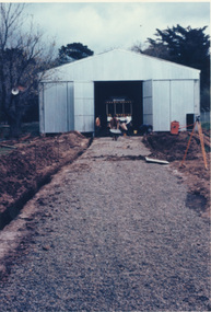 Ballarat Tramway Museum
Photograph - Colour Print/s - set of 9, 29/09/1972 12:00:00 AM
Set of nine colour prints of the drainage works and initial track construction carried out by the BTPS outside the depot on 29/9/1972. Photos with hand written captions on rear. .1 - Drainage works No. 2 Road, BTPS Depot .2 - ditto .3 - ditto .4 - ditto .5 - ditto, working in the pit by the level crossing .6 - Drivers eye view from Car 27, No. 2 road construction commencing - sleepers laid out with rail alongside. .7 - Construction of No. 2 road BTPS depot proceeds .8 - Time: 5.46 3/4 - Subject "The first blow" R. Gilbert, Sec BTPS drives the first "doggie" on the track connecting No. 2 road of the depot to Wendouree Parade. .9 - Time: 5.47pm. Subject: R. Gilbert, Sec BTPS drives the first doggie on the track connecting the depot to Wendouree Parade. Picture take of the first "doggie" being driven home.In ink on rear of each photo "23/9/72" and details - see abovetrams, tramways, depot, construction, gardens, buildings, btps -
 Ballarat Tramway Museum
Photograph - Black & White Photograph/s, Nov. 1965
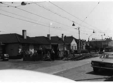
Set of seven Black and white photographs on Kodak paper for the arrangements and work for the track reconstruction of Commercial Road Prahran. Series of photos show Down track already complete. Probably second half of October or early November 1965. (Electric Traction 11/65) (Unusual to have two jobs at once - see Hawthorn Rd - Reg item 1421). Series show the construction method. Temporary track formed by progressively lifting original track on to side of road each night. Relaying then follows progressively. Pictures show almost completed section (1423.1 &2), concreting (1423.3), new rails in situ (1423.4&5),newly moved track (1423.6&7), excavation taking place (1423.7) 1421.1 - Commercial Rd looking west at Charles St showing ramp to temporary city bound track. 1423.2 Ditto - just west of Charles St. 1423.3 Ditto - corner Perth St on left, Hyland St on right. 1423.4 Ditto - between Perth and Donald Sts. Scrubber car No 9. 1423.5 Ditto - looking east between Perth and Donald Sts. - W5 723 on new track, W5 722 on temporary track. 1423.6 Ditto - looking east. Max Hotel on corner of Donald St. 1423.7 Ditto - looking east at corner of Alfred St. Scrubber car No 9. See P.Winspur note with item 1418.trams, tramways, commercial road, reconstruction, trackwork, mmtb, tram 9, tram 723, tram 722 -
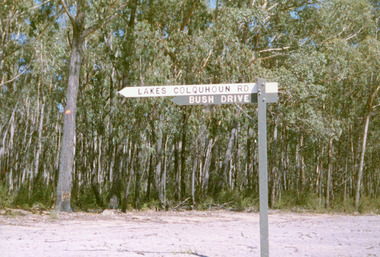 Lakes Entrance Historical Society
Photograph, Jan McDougall, 1999
Also three other photographs of road and signage in Colquhoun Forest.Colour photograph of the bush drive and signage in the vicinity of the old Colquhoun Road, once part it the road network from Lakes Entrance to Bruthen, branching to Nowa Nowa. East Gippsland Victoriahouses, parks, heritage study -
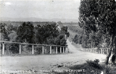 Whitehorse Historical Society Inc.
Photograph - Black and white photograph, Boronia Road, Vermont
Boronia Road Vermont approaching Dandenong Creek.Black and white photo of Boronia Road approaching Dandenong Creek, Vermontboronia road vermont, dandenong creek -
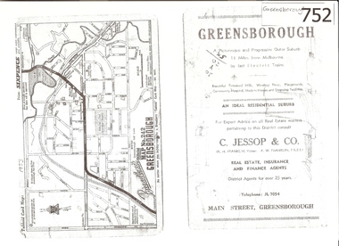 Greensborough Historical Society
Map, Broadbent's, Greensborough, 1953_
This road map was a part of a Broadbent's Melbourne suburban directory from 1953.It shows the lay out of Greensborough's streets in 1953.It also shows some different street names to those used today. It also features a C Jessop & Co. Real estate advertisementA 1 page photocopy of a road map of Greensborough from 1953.Nilgreensborough, c jessop, broadbents, map no 242, road maps, 1953 -
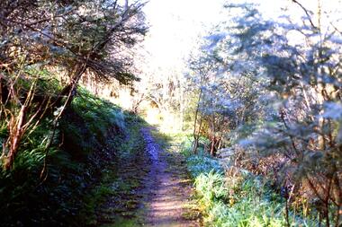 Greensborough Historical Society
Slide - Photograph, John Ramsdale, Along Plenty River near Para Road: Slide 86, 1990s
Photograph shows a track through bushland, along the Plenty River near Para Road, possibly Montmorency.Part of the John Ramsdale collection of slides and audio visual material.Colour photograph scanned from slide.No maker's marks. No caption on slide.plenty river, para road montmorency, bushland -
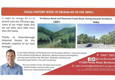 Greensborough Historical Society
Article - Article Newsletter, Colin Brooks, Local history bites: St Helena Road in the 1890's, July 2024
Article from Brooksy's Briefing about St Helena Road as a dirt track in the 1890s compared to today.Newsletter article text with colour imagest helena, colin brooks, st helena road greensborough, greensborough historical society, diamond creek road greensborough -
 Ballarat Tramway Museum
Slide - 35mm slide/s - set of 5, John Theodore, 1973
Yields information about depot activities of the BTPS in building the depot fan and access track.Set of 5 AGFA blue and white plastic mounts 27mm sq slides of work at the depot, following the completion of 1 road, c1974. .1 - 1 road looking towards the depot fan with 26 and 27 in the view. .2 - tram 28 out on 2 road with the damaged end showing. .3 - Checking 1 road with the trolley. Andrew Cook, Peter Rees and Graeme Jordan .4 - 28, 27 and 26 on the depot fan .5 - sawing rails on 1 road to join up with the depot tracks.Various notations by John as to the slide number and the trams in pencil and ink.tramways, trams, btps, depot, track construction, trams, tram 27, tram 26, tram 28 -
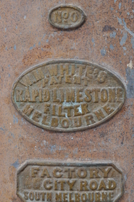 Bendigo Historical Society Inc.
Tool - LIMESTONE WATER FILTER. W.M. WHITES
Limestone water Filter. Approx 800mm x 400mm. Three Brass labels on the outside. One contains the label 'No. 0'. Another circular plague contains the lettering. 'W.M.Whites Melbourne- Patent - Rapid Limestone Filter' . Another Contains the label ' Factory City Road, South Melbourne'. The metal tank has two brown handles and a brass tap at the base. Inside is a spherical limestone ball with a rod through the centre.W.M.Whites, City Road, South Melbourne -
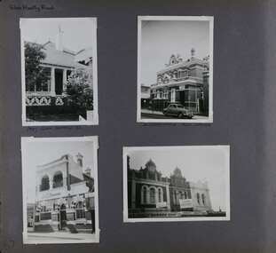 Glen Eira Historical Society
Album - Album page, Glen Huntly Road, Circa 1972
This photograph is part of the Caulfield Historical Album 1972. This album was created in approximately 1972 as part of a project by the Caulfield Historical Society to assist in identifying buildings worthy of preservation. The album is related to a Survey the Caulfield Historical Society developed in collaboration with the National Trust of Australia (Victoria) and Caulfield City Council to identify historic buildings within the City of Caulfield that warranted the protection of a National Trust Classification. Principal photographer thought to be Trevor Hart, member of Caulfield Historical Society. Most photographs were taken between 1966-1972 with a small number of photographs being older and from unknown sources. All photographs are black and white except where stated, with 386 photographs over 198 pages. The Former Elsternwick Post Office is on the Victorian Heritage Register H0640 with a full significance statement and also HO29 with the City of Glen Eira. Much of the Glen Huntly Road heritage retail strip is heritage listed in HO72 with the City of Glen Eira.Page 67 of Photograph Album with four photographs (three portrait and one landscape) of different properties on Glen Huntly Road - a house, Post Office, ANZ Bank and shops.Hand written: Glen Huntly Road [top left] / 1027 GLEN HUNTLY RD [under top left photo] / ELSTERNWICK POST OFFICE [under top right photo] / 67 [bottom left] trevor hart, glen huntly road, elsternwick, shops, caulfield, post offices, glenhuntly road, banks, brick houses, shopping centres -
 Ballarat Tramway Museum
Negative - Geelong Scrubber Moorabool Street at McKillop St, Wal Jack, July 1950
Photo of the Geelong scrubber on a wide road, single track in Moorabool St at McKillop St - Note the pole with the single track bracket arm. See item 9049 for Wal Jack's notes which dates the photo as July 1950.Yields information about the use of the Geelong Scrubber or water tram.Negative and Digital images of the Wal Jack Geelong Negative file. trams, tramways, geelong, scrubber tram, tram scrubber -
 Ballarat Heritage Services
Photograph, The Deserted Great Ocean Road at Apollo Bay during the Covid 19 Lockdown, 20/09/2021
During the Covid19 Pandemic lockdowns resulted in empty roads. Colour photographs of plaques commemorating the opening of the Great Ocean Road, 2020great ocean road, plaque, apollo bay, david mclaren, pandemic, covid19 -
 City of Kingston
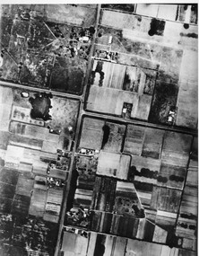
Photograph - Black and white, c. 1944
Aerial photograph of Moorabbin, including Chesterville Road, Keys Road and Wickham Road, Moorabbin, Briggs cottage, Neill's waterhole, McKittrick property, site of FRUMELBlack and white aerial view of Moorabbin. Houses, market garens, roads, and water features are all clearly visible.Handwritten in red ink on reverseL A 603 / 97% [in red circle] Handwritten in blue ink on reverse: 9502 06111 / M'bbinmoorabbin, city of moorabbin, chesterville, keys, wickham -
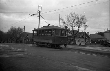
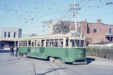 Melbourne Tram Museum
Photograph - Five color slides - tram PCC 980, 9-8-1970
Set of four colour slides taken during the Monash Railway club tour on 9-8-1970 using PCC 980 from Malvern Tram Depot. The route number and destinations are for show only. Photographs by Warren Doubleday.Yields information on Monash Railway club tour, the trams used and the locations.Set of five Anscochrome colour slides, of Melbourne tram PCC 980 on a Monash Railway Club tour - 9-8-1970 .1 - PCC 980 on the depot access tracks for Malvern Tram Depot in Coldblo Road .2 - With the Malvern Tram Depot in the view .3 - In Dandenong Road at Hawthorn Road .4 - Crossing Hawthorn Road - has a tram shelter in the view. .5 - About to use the then new Nolan St (now Southbank Blvd) crossover.Has photographers slide numbers on each slide.monash railway club, tram 980, malvern depot, hawthorn road, dandenong road, nolan st, tramways, trams, pcc class -
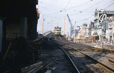 Melbourne Tram Museum
Slide - Set of 4, John Webster, 16/11/1959 12:00:00 AM
Set of four Colour slides, Kodak, white cardboard of trams using the Flinders St overpass of King St, 16-11-59. .1 - W2 538 descending the temporary track over King St as part of the first stage of construction. Tram has the destination of East Kew Route 40. .2 - ditto at the base of the bridge. Tram has adverts for Uncle Toby's Oats, .3 - W5 725 entering the temporary track near Queen St. Tram has destination of Spencer St, route 48 and adverts for 3AW, Pimms No. 1 and Penfolds Wine. On the far right is a MMTB Mk III bus to Kew - Earl St. .4 - ditto with the Yarra Family Hotel in the background. Note the tram stop sign. .In the background are adverts for Penfolds Wines, Bushels, the Flinders St viaduct, Nestles Milk, Girlings Store and the Cafe / Milk bar that was under the viaduct.Hand writing on rear in ink; .1 - 16-11-59 - Melbourne Vic. .2 - ditto ..3 and .4 - 16-11-59 Tram 725 entering temporary track in Flinders St Melbourne Vic.trams, tramways, trackwork, flinders st, king st, track construction, bridges, w2 class, east kew, route 40, w5 class, route 48, tram stops, tram 538, tram 725 -
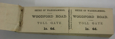 Warrnambool and District Historical Society Inc.
Functional object - Ticket Book, Fairfax & Laurie, Printers, Shire of Warrnambool, Woodford Road Toll Gate, 1s 6d, Circa 1866
In 1866, in an effort to maintain the main roads of the region it was decided to establish toll roads on the Belfast, Woodford, Purnim and Allansford roads. Gates were erected and the leases were disposed of by auction. In 1867 the Woodford tollhouse was destroyed by fire suspected to be deliberate. The tolls were removed three years later after much opposition.This item has historic significant as in the early years(1864) of Warrnambool Tolls were levied on the three main roads leading from Warrnambool into the Shire. In 1864 the Shire of Warrnambool decided that tolls were the only just way to raise funds for maintenance of metalled roads. the Shire of Warrnambool had been created in 1863 from the old Warrnambool Roads Board.Small booklet 140mms long by 40mms wide 13mm depth. Blue & grey marbled cardboard covers back & green oiled cloth binding. Inside full book of double side ticket stubs with perforations in the middle.Shire of Warrnambool. WOODFORD ROAD. TOLL GATE 1s. 6d. Fairfax & Laurie, Printerswarrnambool, shire of warrnambool, woodford road, main belfast road, toll gate, toll tickets, woodford toll house 1866, fairfax & laurie printers -
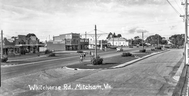 Whitehorse Historical Society Inc.
Photograph - Black and white negative - Whitehorse Road Mitcham c. 1949, Harold Ernest Millane, Whitehorse Road Mitcham, Vic. c. 1949, circa. 1949
This image was one of a series taken by Harold Millane in the late 1940's. They were printed onto post cards. Mary Millane, Harold's wife, printed captions on each negative with Indian ink. The series includes a variety of views of Mitcham, Vermont, Nunawading, Park Orchards and Doncaster East. The post cards were sold as souvenirs in the Millane shop on the N-E corner of Station Street and Whitehorse Road, Mitcham (originally the Mitcham Post Office).Clear photograph showing details of shops, vehicles, streetscape, lighting.Celluloid half plate B + W negative.Whitehorse Road Mitcham, Vic. hardy scott, h. s .beckwith, richards drapers, d. g. williamson, r. gracie, s. kelly, cenotaph, mitcham memorial hall -
 Melbourne Tram Museum
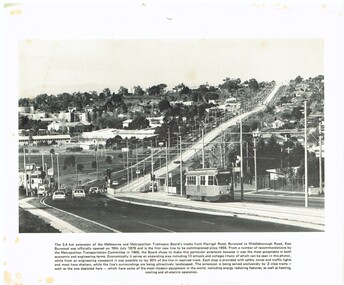
Photograph - Illustration/s, c1979
Illustration - black and white - possibly cut from a calendar sheet - of Burwood Highway, looking east just west of the Elgar Road intersection. Shows the relatively new track and Z25 inbound to Spencer St. Has a golden fleece service station on the left hand side. Shows the road arrangements at the time. Caption to illustration notes first new extension since 1956, opening date, reserved track and that Z class trams are used on it. One of the 1969 Metropolitan Transport Committee recommendations. Two copies held.trams, tramways, burwood highway, burwood, track construction, mmtb, z class, tram 25 -
 Bendigo Historical Society Inc.
Map - MINING REPORTS - MAP OF COLLMANN AND TACCHI SHAFT
Collman and Tacchi shaft drawn on map corner of Dowding Street and Mt. Korong Road, California Gully, Bendigo. Mt Korong Road later became Eaglehawk Road. Hand drawn map showing the Collmann and Tacchi Shaft with No 17 Crosscut with the distances in feet and inches and the compass bearing of each leg. It is beside Mt Korong Road, near Dowding Street. Some boundary lines are drawn. Also on the map is Lansell's C and T across the road.map, bendigo, goldfields, mining reports, map of collmann and tachi shaft, collmann and tacchi shaft, lansell's c and t -
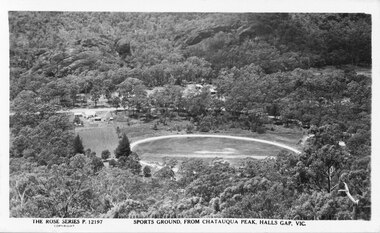 Halls Gap & Grampians Historical Society
Photograph - B/W
This is a postcard of the sports ground in Halls Gap, taken from Chatauqua Peak. It is No. 12197 in the Rose Series of postcards.The photo shows a round clearing (sports ground), seen from above, in the midst of bush. There are some bare strips in the middle of the field and a track around its perimeter. Some buildings are visible to the left of the field and a road runs behind it. There are more buildings just visible through the bush in the centre, on the far side of the road."The Rose Series P. 12197, Sports Ground, from Chatauqua Peak, Halls Gap, Vic" on bottom of postcard.recreation, sport -
 Port Melbourne Historical & Preservation Society
Photograph - Making Tracks exhibition, Station Pier, Port Melbourne, Ann Smallpage, 12 Sep 2004
9 members attended the minister's breakfast celebrating the sesquintennial of the M&HB Railway & Pier, and others joined them at noon to see the "Making Tracks" exhibition. Both exhibition and the book "Welcome & Farewell" were launched at the breakfast, and also plaques for Station Pier, PMR Station & Flinders Street Station. Ref items 1947.01-.13 for presentation material. 1946 for book launched at this event.Set of 24 photos taken at 'Making Tracks' exhibition launch breakfast at Station Pier celebrating 150th anniversay of Pier & railway (12-09-2004). Includes: .01: Launch of "Farewell & Welcome" with Transport Minister Peter Batchelor and Jill Barnard with Sonia Jennings. .02: Jill Barnard presenting the book to PMH&PS Secretary Pat Grainger. .03 & .04: RHSV launch of 'Making Tracks'. .05 & .06: Meyer Eidelson & Pat Grainger at exhibition. .07: Norah Howard & Lois Daley at exhibition. .08: Norah Howard & Pat Grainger. .09-.24: Exhibition details.transport - railways, celebrations fetes and exhibitions, arts and entertainment - literature, barnard, jill, jennings, sonia, norah howard, meyer eidelson, pat grainger, batchelor, peter -
 Glenelg Shire Council Cultural Collection
Photograph - Photograph - Blacknose Quarry, Portland, 05/11/1952
Port of Portland Authority ArchivesFront: Front- Blacknose quarry face 5/11/52 looking north from access road'- printed bottom frame. Back- Purple PHT stampport of portland archives, blacknose quarry, 1950s, portland harbour -
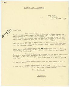 Ringwood and District Historical Society
Letter, Borough of Ringwood engineer stating that a road between Warrandyte Road and Adelaide St has been completed in 1931
1929 saw the establishment of the Ringwood Bowls Club initially located on the land now occupied by the Eastland Shopping Centre. It moved to its current location in Loughnan Road, Ringwood in 1997.Borough of Ringwood engineer stating that a road between Warrandyte Road and Adelaide St has been completed in 1931. The proposed name of Bamford Grove.city of ringwood bowls club, ringwood bowling club, ringwood bowls club, lawn bowls, bowling