Showing 1307 items matching "water in australia"
-
 National Vietnam Veterans Museum (NVVM)
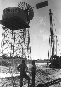
Photograph, Gibbons, Denis, Hoi My Southern Cross Windmill 1
Denis Gibbons (1937 – 2011) Trained with the Australian Army, before travelling to Vietnam in January 1966, Denis stayed with the 1st Australian Task Force in Nui Dat working as a photographer. For almost five years Gibbons toured with nine Australian infantry battalions, posting compelling war images from within many combat zones before being flown out in late November 1970 after sustaining injuries. The images held within the National Vietnam Veterans Museum make up the Gibbons Collection.A black and white photograph of the Hoi My Southern Cross Windmill water pump and the water pressure header tower. Pipes and taps were laid from the header tank to various access points throughout the village.photograph, 1st australian civil affairs unit, hoi my southern cross windmill, gibbons collection catalogue, denis gibbons, photographer, vietnam war -
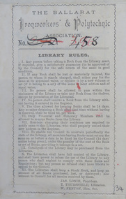
 Federation University Historical Collection
Booklet, University of Ballarat, Research@YourUB, 2007 -2010
Research@YourUB is a newsletter highlighting research at the University of Ballarat.1) Spring 2009 .2) Spring 2007 - Rob Wallis, green packaging, mould, food safety, Zhaohao Sun, Widcorp, Jesica Block, Arts Academy anniversary, Dorothy Wickham, Dora Pearce, Loris Button, SmartGreen, Marilyn Davidson, Overcoming bullying in schools, overweight patients. .3) Autumn 2009 - Australian Security Laboratory to fight cybercrime, brewing better beer, John Yearwood, Centre do Informatics and Applied Optimizaton, John Smyth, Angela Murphy? Willows by the water. Patrice Braun, Laura Kostanski, preventing injuries, why should we research art. .4) October 2009 - Future Research Directions .5) January 2009 - Research themes, Wayne Robinson, John yearwood, Andrew Stranieri, Peter Gell, Julian Lowe, John Smyth, John McDonald, Caroline Finch, Dennis Else, Informatics and Applied Optimization, Regional Futures, Disadvantage and Inequality in Education and Health, Injury Prevention and Safety Promotion. .6) Spring 2010 - Frank Stagnitti, Brad Mitchell, Diane Clingin, Robyn Brandenburg, Amanda McGraw-Pleban, Charlynn Miller, Fadi Charchar, Robert Hodder, Amber Stabek, ACSL maps, Murray Darling Basin, Peter Gell, John Smyth, Kate Brass, gaming machines, John McDonald, Helen Aucote, Andrew Cooper, Deborah greeenslade, Dara twomey, Andrew Warnock, synthetic grass, .7) Autumn 2006 - Wayne Robinson, toenail research, Dora Pearce, biodiversity in modified lansdscapes, Centre for Informatics and Applied Optomization (CIAO), John Yearwood, Lawrie Angus, Barry Golding, Georgina Tsolidis, John Smyth, Maxine Cooper, Mary Hollick, Emil Milos, Jeff Woodger, Michelle Ziccolo, Rosemary Green, Raelene Gregory, Julian Lowe, Jessie Harman, Debora Campbell, John McDonald, Denise Corboy, Catherine Knox, Henry Lawson, Meg Tasker, Warren Young, Amanda Telford.university of ballarat, wallis, wickham, wayne robinson, toenail research, dora pearce, biodiversity in modified landscapes, centre for informatics and applied optimization, john yearwood, lawrie angus, barry golding, georgina tsolidis -
 City of Greater Bendigo - Civic Collection
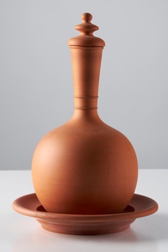
Domestic object - Water Monkey, Bendigo Pottery, 1880 - 1910
Vessels for storing water such as these are common throughout the ages and evident in the pottery of the middle east, Mediterranean and Africa. Between 1880 and 1910 Bendigo Pottery produced these as part of their terracotta ware range. Established by George Guthrie in 1857 (about 5km north of its current site) and then again seven years later in 1864 after it initially closed, Bendigo Pottery remains one of the most influential and longest running Pottery’s in Australia. Over the years the Pottery has contributed to the growth and development of the district through both its products including building products, table ware and decorative and commemorative war as well as artistically, being responsible for training and supporting many potters locally. The City of Greater Bendigo has had a long history of partnering with Bendigo Pottery to produce tourism tableware and art pieces and the Civic Collection holds a number of important items within its collection.Polished terracotta water holder with saucer and stopper. Globular body with rounded base. The shoulders taper into long cylindrical neck, no handle or pouring spout. Surface is undecorated expect for two rings at base of neck. This is the smaller of the two. 0430a stopper; 0430b vessel; 0430c saucerNone foundbendigo pottery, george gutherie, city of greater bendigo tourism -
 City of Greater Bendigo - Civic Collection
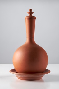
Domestic object - Water Monkey
Vessels for storing water such as these are common throughout the ages and evident in the pottery of the middle east, Mediterranean and Africa. Between 1880 and 1910 Bendigo Pottery produced these as part of their terracotta ware range. Established by George Guthrie in 1857 (about 5km north of its current site) and then again seven years later in 1864 after it initially closed, Bendigo Pottery remains one of the most influential and longest running pottery’s in Australia. Over the years the Pottery has contributed to the growth and development of the district through both its products including building products, table ware and decorative and commemorative ware, as well as artistically, being responsible for training and supporting many local potters. The City of Greater Bendigo has had a long history of partnering with Bendigo Pottery to produce tourism tableware and art pieces and the Civic Collection holds a number of important items within its collection.Polished terracotta water holder with saucer and stopper. Globular body with rounded base. The shoulders taper into long cylindrical neck, no handle or pouring spout. Surface is undecorated except for two rings at base of neck. This is the larger of the two. 0431a stopper; 0431b vessel; 0431c saucerNone foundbendigo pottery, city of greater bendigo tourism, george guthrie -
 National Vietnam Veterans Museum (NVVM)
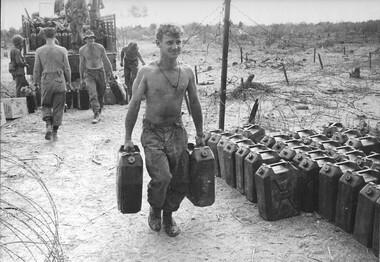
Photograph, Gibbons, Denis, Fire Support Base Peggy
Denis Gibbons (1937 – 2011) Trained with the Australian Army, before travelling to Vietnam in January 1966, Denis stayed with the 1st Australian Task Force in Nui Dat working as a photographer. For almost five years Gibbons toured with nine Australian infantry battalions, posting compelling war images from within many combat zones before being flown out in late November 1970 after sustaining injuries. The images held within the National Vietnam Veterans Museum make up the Gibbons Collection. A black and white photograph of Diggers of 4 RAR/NZ (ANZAC) unloading water at Fire Support Base 'Peggy'. Water was a major supply problem for the diggers in the field. This water had been transported from the 1st Australian Task Force Base at Nui Dat, Phuoc Tuy Province.photograph, fire base peggy, 1st atf base, nui dat, phuoc tuy province, gibbons collection catalogue, denis gibbons, photographer, vietnam war, diggers, 4 rar/nz (anzac) -
 Federation University Historical Collection
Book, Geological Gossip or Stray Chapters on Earth and Ocean, 1860, 1860
Brown hard covered book. Chapter 16 is on gold deposits and discusses the discovery of gold in California and Australia.Brown hard covered book geology, water, rivers, the atlantic, great deep, africa, australian interior, eyre's expedition, murray river, darling river, earthqaukes, leichardt, moreton bay, volcanos, darwin's theory, evolution, egyptian race, human remains in caverns and gravel, rocks, metamorphism, iron ores, coal, coal fields, gold deposits, california, water-glass, artificial stone, porous stones, cements -
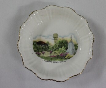
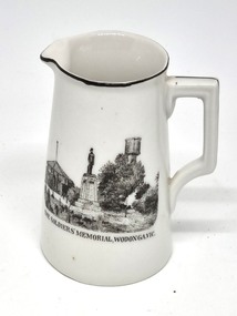 Wodonga & District Historical Society Inc
Souvenir - Souvenir Cream Jug - Soldiers' Memorial, Wodonga
This item is from a collection donated by descendants of John Francis Turner of Wodonga. A wide range of small china pieces carrying scenic views of holiday destinations or key locations were a popular kind of souvenir during much of the 20th century. Several different items have been produced to commemorate Wodonga and its landmarks over time. These items document key changes in Wodonga and its heritage. This plate depicts three key landmarks in Wodonga. THE SOLDIERS' MEMORIAL in Wodonga was unveiled on Tuesday 18th November 1924. It was designed by Messrs. Hosken & Co., of Hawthorn, Victoria. The monument is all of Australian workmanship. The pedestal is made of Harcourt granite, 9ft x 9ft at the base, and rising in seven courses to a height of 10ft 2in. The emblems (rising sun and wreath) are of bronze, and the lettering of the inscription and names of fallen soldiers are in raised lead letters. Originally the Memorial was completed with a full life size, 6ft in height, sculpture of an Australian soldier in Sicilian marble. The memorial bore the inscriptions: ERECTED BY THE RESIDENTS OF WODONGA AND DISTRICT IN MEMORY of the Men of this Town and District who fell in the Great War, 1914-1919, Also in grateful recognition of the men who served and returned. “Lest We Forget.” In 1982, due to frequent vandalism and high cost of materials to repair, the soldier statue was removed and later installed at the RSL Rooms. THE WATER TOWER is a major landmark of High Street, Wodonga. It began operation from January 1924 until it ceased operation in 1959. It stood unused for a decade until the lower section was modified and put to use as “ The Tower’s Cobbler’s Inn” in 1962. In 1972 Wodonga City Council proposed to demolish the Tower. Their suggestion received an unfavorable response from the city’s citizens, so the Tower still stands today. THE BAND ROTUNDA was officially opened on Sunday 5th September 1920 at the naming of the triangular reserve at the corner of High and Hovell Streets as Woodland Grove. The Wodonga Band gave a public performance on this occasion. The tri-coloured ribbon, which stretched across the entrance to the Rotunda was cut by Mrs R.H Murphy, daughter of Mr. John Woodland, secretary of the Wodonga Shire Council for 35 years, after whom the area was named. The rotunda has since been moved to Martin Park, Wodonga.This item comes from a collection used by a prominent citizen of Wodonga. It is also an excellent example of souvenir items created featuring landmarks to represent the city of Wodonga.White glazed porcelain cream jug with grooved square handle. The base is unglazed. The rim and outer face of the handle are outlined in black paint. On one side of the jug is a black transfer print of a the Wodonga Soldiers' Memorial. Text underneath the scene reads "THE SOLDIERS' MEMORIAL, WODONGA, VIC."'. The manufacturer's trademark is printed on the base of the jug. RKG stood for Rudolf Kampf of Grunlas. The mark with the initials under the crown was used from 1921 to 1938.Beneath the image: 'THE SOLDIERS' MEMORIAL WODONGA VIC" Under the jug Manufacturer's trademark printed in orange paint, in a circular formation '(crown) / RK / G' ('RK / G' within circle with handles) above the words "Made in Czechoslovakia"domestic items, souvenir wodonga, woodland grove wodonga -
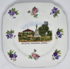 Wodonga & District Historical Society Inc
Souvenir - China Souvenir Plate Soldiers' Memorial. Wodonga, Victoria China, c1924 - 1939
This item is from a collection donated by descendants of John Francis Turner of Wodonga. A wide range of small china pieces carrying scenic views of holiday destinations or key locations were a popular kind of souvenir during much of the 20th century. Several different items have been produced to commemorate Wodonga and its landmarks over time. These items document key changes in Wodonga and its heritage. This plate depicts three key landmarks in Wodonga. THE SOLDIERS' MEMORIAL in Wodonga was unveiled on Tuesday 18th November 1924. It was designed by Messrs. Hosken & Co., of Hawthorn, Victoria. The monument is all of Australian workmanship. The pedestal is made of Harcourt granite, 9ft x 9ft at the base, and rising in seven courses to a height of 10ft 2in. The emblems (rising sun and wreath) are of bronze, and the lettering of the inscription and names of fallen soldiers are in raised lead letters. Originally the Memorial was completed with a full life size, 6ft in height, sculpture of an Australian soldier in Sicilian marble. The memorial bore the inscriptions: ERECTED BY THE RESIDENTS OF WODONGA AND DISTRICT IN MEMORY of the Men of this Town and District who fell in the Great War, 1914-1919, Also in grateful recognition of the men who served and returned. “Lest We Forget.” In 1982, due to frequent vandalism and high cost of materials to repair, the soldier statue was removed and later installed at the RSL Rooms. THE WATER TOWER is a major landmark of High Street, Wodonga. It began operation from January 1924 until it ceased operation in 1959. It stood unused for a decade until the lower section was modified and put to use as “ The Tower’s Cobbler’s Inn” in 1962. In 1972 Wodonga City Council proposed to demolish the Tower. Their suggestion received an unfavorable response from the city’s citizens, so the Tower still stands today. THE BAND ROTUNDA was officially opened on Sunday 5th September 1920 at the naming of the triangular reserve at the corner of High and Hovell Streets as Woodland Grove. The Wodonga Band gave a public performance on this occasion. The tri-coloured ribbon, which stretched across the entrance to the Rotunda was cut by Mrs R.H Murphy, daughter of Mr. John Woodland, secretary of the Wodonga Shire Council for 35 years, after whom the area was named. The rotunda has since been moved to Martin Park, Wodonga.This item comes from a collection used by a prominent citizen of Wodonga. It is also an excellent example of souvenir items created featuring landmarks to represent the city of Wodonga.A china plate depicting the Soldiers' Memorial Wodonga. The central coloured image is surrounded by a 8 representations of a variety of flowers and a silver edge trim. The makers mark underneath the dish was used between 1918 - 1939 so assists in establishing provenance of the irem.Beneath image: "SOLDIERS' MEMORIAL WODONGA On back of dish, Beneath a crown " VICTORIA CHINA CZECHOSLAVAKIA"victoria china, souvenir wodonga, wodonga soldiers memorial, woodland grove wodonga -
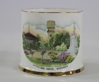 Wodonga & District Historical Society Inc
Memorabilia - China Souvenir Cup Woodland Grove Wodonga, c. 1925 - 1940
A wide range of small china pieces carrying scenic views of holiday destinations or key locations were a popular kind of souvenir during much of the 20th century. Several different items have been produced to commemorate Wodonga and its landmarks over time. These items document key changes in Wodonga and its heritage. This cup depicts three key landmarks in Wodonga. THE SOLDIERS' MEMORIAL in Wodonga was unveiled on Tuesday 18th November 1924. It was designed by Messrs. Hosken & Co., of Hawthorn, Victoria. The monument is all of Australian workmanship. The pedestal is made of Harcourt granite, 9ft x 9ft at the base, and rising in seven courses to a height of 10ft 2in. The emblems (rising sun and wreath) are of bronze, and the lettering of the inscription and names of fallen soldiers are in raised lead letters. Originally the Memorial was completed with a full life size, 6ft in height, sculpture of an Australian soldier in Sicilian marble. The memorial bore the inscriptions: ERECTED BY THE RESIDENTS OF WODONGA AND DISTRICT IN MEMORY of the Men of this Town and District who fell in the Great War, 1914-1919, Also in grateful recognition of the men who served and returned. “Lest We Forget.” In 1982, due to frequent vandalism and high cost of materials to repair, the soldier statue was removed and later installed at the RSL Rooms. THE WATER TOWER is a major landmark of High Street, Wodonga. It began operation from 1924 until it ceased operation in 1959. It stood unused for a decade until the lower section was modified and put to use as “ The Tower’s Cobbler’s Inn” in 1962. In 1972 Wodonga City Council proposed to demolish the Tower. Their suggestion received an unfavorable response from the city’s citizens, so the Tower still stands today. THE BAND ROTUNDA was officially opened on Sunday 5th September 1920 at the naming of the triangular reserve at the corner of High and Hovell Streets as Woodland Grove. The Wodonga Band gave a public performance on this occasion. The tri-coloured ribbon, which stretched across the entrance to the Rotunda was cut by Mrs R.H Murphy, daughter of Mr. John Woodland, secretary of the Wodonga Shire Council for 35 years, after whom the area was named. The rotunda has since been moved to Martin Park, Wodonga. This item has local historic and social significance as it depicts which features of the city the community valued in the past. It has artistic significance as an example of the kinds of souvenirs used widely across Australia to represent communities and the landscape.A white souvenir cup made from china with a water colour image of Woodland Grove, Wodonga which incorporates the Soldier Memorial, Water Tower and the Rotunda."WOODLAND GROVE, WODONGA."souvenirs, wodonga, woodland grove, soldiers memorial, wodonga landmarks -
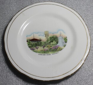
 Wodonga & District Historical Society Inc
Memorabilia - China Souvenir Bowl Woodland Grove Wodonga, c. 1920 - 1940
A wide range of small china pieces carrying scenic views of holiday destinations or key locations were a popular kind of souvenir during much of the 20th century. Several different items have been produced to commemorate Wodonga and its landmarks over time. These items document key changes in Wodonga and its heritage. This plate depicts three key landmarks in Wodonga. THE SOLDIERS' MEMORIAL in Wodonga was unveiled on Tuesday 18th November 1924. It was designed by Messrs. Hosken & Co., of Hawthorn, Victoria. The monument is all of Australian workmanship. The pedestal is made of Harcourt granite, 9ft x 9ft at the base, and rising in seven courses to a height of 10ft 2in. The emblems (rising sun and wreath) are of bronze, and the lettering of the inscription and names of fallen soldiers are in raised lead letters. Originally the Memorial was completed with a full life size, 6ft in height, sculpture of an Australian soldier in Sicilian marble. The memorial bore the inscriptions: ERECTED BY THE RESIDENTS OF WODONGA AND DISTRICT IN MEMORY of the Men of this Town and District who fell in the Great War, 1914-1919, Also in grateful recognition of the men who served and returned. “Lest We Forget.” In 1982, due to frequent vandalism and high cost of materials to repair, the soldier statue was removed and later installed at the RSL Rooms. THE WATER TOWER is a major landmark of High Street, Wodonga. It began operation from 1924 until it ceased operation in 1959. It stood unused for a decade until the lower section was modified and put to use as “ The Tower’s Cobbler’s Inn” in 1962. In 1972 Wodonga City Council proposed to demolish the Tower. Their suggestion received an unfavorable response from the city’s citizens, so the Tower still stands today. THE BAND ROTUNDA was officially opened on Sunday 5th September 1920 at the naming of the triangular reserve at the corner of High and Hovell Streets as Woodland Grove. The Wodonga Band gave a public performance on this occasion. The tri-coloured ribbon, which stretched across the entrance to the Rotunda was cut by Mrs R.H Murphy, daughter of Mr. John Woodland, secretary of the Wodonga Shire Council for 35 years, after whom the area was named. The rotunda has since been moved to Martin Park, Wodonga. This item has local historic and social significance as it depicts which features of the city the community valued in the past. It has artistic significance as an example of the kinds of souvenirs used widely across Australia to represent communities and the landscape.A white glazed china souvenir bowl. Frilled edge. Includes a painted representation of Woodland Grove, Wodonga, VictoriaBeneath the painted central image "WOODLAND GROVE, WODONGAwodonga, souvenirs, woodland grove, ceramics -
 Wodonga & District Historical Society Inc
Souvenir - Souvenir Cup and Saucer Woodland Grove, Wodonga, Victoria, Royal Stafford China, c1940s
This item is from a collection donated by descendants of John Francis Turner of Wodonga. Mr. Turner was born on 6 June 1885. He completed all of his schooling at Scotts Boarding School in Albury, New South Wales. On leaving school, he was employed at Dalgety’s, Albury as an auctioneer. In 1924 John was promoted to Manager of the Wodonga Branch of Dalgety’s. On 15/03/1900 he married Beatrice Neal (born 7/12/1887 and died 7/2/1953) from Collingwood, Victoria. They had 4 daughters – Francis (Nancy), Heather, Jessie and Mary. In 1920, the family moved From Albury to Wodonga, purchasing their family home “Locherbie” at 169 High Street, Wodonga. "Locherbie" still stands in Wodonga in 2022. The collection contains items used by the Turner family during their life in Wodonga. A wide range of small china pieces carrying scenic views of holiday destinations or key locations were a popular kind of souvenir during much of the 20th century. Several different items have been produced to commemorate Wodonga and its landmarks over time. These items document key changes in Wodonga and its heritage. This plate depicts three key landmarks in Wodonga. THE SOLDIERS' MEMORIAL in Wodonga was unveiled on Tuesday 18th November 1924. It was designed by Messrs. Hosken & Co., of Hawthorn, Victoria. The monument is all of Australian workmanship. The pedestal is made of Harcourt granite, 9ft x 9ft at the base, and rising in seven courses to a height of 10ft 2in. The emblems (rising sun and wreath) are of bronze, and the lettering of the inscription and names of fallen soldiers are in raised lead letters. Originally the Memorial was completed with a full life size, 6ft in height, sculpture of an Australian soldier in Sicilian marble. The memorial bore the inscriptions: ERECTED BY THE RESIDENTS OF WODONGA AND DISTRICT IN MEMORY of the Men of this Town and District who fell in the Great War, 1914-1919, Also in grateful recognition of the men who served and returned. “Lest We Forget.” In 1982, due to frequent vandalism and high cost of materials to repair, the soldier statue was removed and later installed at the RSL Rooms. THE WATER TOWER is a major landmark of High Street, Wodonga. It began operation from January 1924 until it ceased operation in 1959. It stood unused for a decade until the lower section was modified and put to use as “ The Tower’s Cobbler’s Inn” in 1962. In 1972 Wodonga City Council proposed to demolish the Tower. Their suggestion received an unfavorable response from the city’s citizens, so the Tower still stands today. THE BAND ROTUNDA was officially opened on Sunday 5th September 1920 at the naming of the triangular reserve at the corner of High and Hovell Streets as Woodland Grove. The Wodonga Band gave a public performance on this occasion. The tri-coloured ribbon, which stretched across the entrance to the Rotunda was cut by Mrs R.H Murphy, daughter of Mr. John Woodland, secretary of the Wodonga Shire Council for 35 years, after whom the area was named. The rotunda has since been moved to Martin Park, Wodonga. This item comes from a collection used by a prominent citizen of Wodonga. It is also representative of a domestic item common in the 1940s and features significant landmarks used in many forms to represent the city of Wodonga.This bone china cup and saucer set features an image of Woodland Grove. Wodonga, Victoria. The image incorporates landmarks in Woodland Grove, including the Soldiers' Memorial, the Rotunda and the Water Tower. There is a makers' mark imprinted on the underside of the plate."ROYAL STAFFORD/BONE CHINA/ MADE IN ENGLAND/ 423" . A crown is in the centre of the textmemorabilia, woodland grove, wodonga victoria -
 Wodonga & District Historical Society Inc
Memorabilia - Souvenir Plate Woodland Grove, Wodonga, Victoria, Royal Stafford China
A wide range of small china pieces carrying scenic views of holiday destinations or key locations were a popular kind of souvenir during much of the 20th century. Several different items have been produced to commemorate Wodonga and its landmarks over time. These items document key changes in Wodonga and its heritage. This plate depicts three key landmarks in Wodonga. THE SOLDIERS' MEMORIAL in Wodonga was unveiled on Tuesday 18th November 1924. It was designed by Messrs. Hosken & Co., of Hawthorn, Victoria. The monument is all of Australian workmanship. The pedestal is made of Harcourt granite, 9ft x 9ft at the base, and rising in seven courses to a height of 10ft 2in. The emblems (rising sun and wreath) are of bronze, and the lettering of the inscription and names of fallen soldiers are in raised lead letters. Originally the Memorial was completed with a full life size, 6ft in height, sculpture of an Australian soldier in Sicilian marble. The memorial bore the inscriptions: ERECTED BY THE RESIDENTS OF WODONGA AND DISTRICT IN MEMORY of the Men of this Town and District who fell in the Great War, 1914-1919, Also in grateful recognition of the men who served and returned. “Lest We Forget.” In 1982, due to frequent vandalism and high cost of materials to repair, the soldier statue was removed and later installed at the RSL Rooms. THE WATER TOWER is a major landmark of High Street, Wodonga. It began operation from 1924 until it ceased operation in 1959. It stood unused for a decade until the lower section was modified and put to use as “ The Tower’s Cobbler’s Inn” in 1962. In 1972 Wodonga City Council proposed to demolish the Tower. Their suggestion received an unfavorable response from the city’s citizens, so the Tower still stands today. THE BAND ROTUNDA was officially opened on Sunday 5th September 1920 at the naming of the triangular reserve at the corner of High and Hovell Streets as Woodland Grove. The Wodonga Band gave a public performance on this occasion. The tri-coloured ribbon, which stretched across the entrance to the Rotunda was cut by Mrs R.H Murphy, daughter of Mr. John Woodland, secretary of the Wodonga Shire Council for 35 years, after whom the area was named. The rotunda has since been moved to Martin Park, Wodonga. This bone china plate features an image of Woodland Grove. Wodonga, Victoria. The image incorporates landmarks in Woodland Grove, including the Soldiers' Memorial, the Rotunda and the Water Tower. There is a makers' mark imprinted on the underside of the plate."ROYAL STAFFORD/BONE CHINA/ MADE IN ENGLAND/ 423" . A crown is in the centre of the textmemorabilia, woodland grove, wodonga victoria -
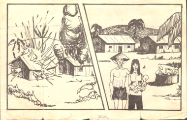 National Vietnam Veterans Museum (NVVM)
Document, Surrender Leaflet, 1968-1973
Black and white surrender leaflet. One side shows contrasting pictures of two houses - one exploding and burning with the other house in a peaceful setting with a couple holding a child and other villagers drawing water from a well. Reverse has Vietnamese writing with a signature and a black stampVietnamese message in letter form. Circular stamp with following writing - "Viet-nam Coung Hoa Tinh Phuoc-Tuy"leaflet, propaganda, psychology, military, instructions, surrender, sgt a moylan, 4 platoon, b coy, 7 rar, 7th battalion, 16063, royal australian infantry corps, arnold george moylan -
 Lakes Entrance Historical Society
Book, State Rivers and Water Supply Commission, The State of the Rivers Victoria Australia, 1983
... of the Rivers Victoria Australia Book State Rivers and Water Supply ...The third (1983) report by the Standing Consultative Committee on River Improvement, giving an overall review of the state of the rivers of Victoria and the Murray. The subject is covered from the catchment to usage, pollution and drainage. Includes caswaterways, water supply, water pollution -
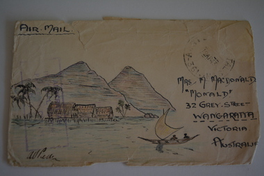 Wangaratta RSL Sub Branch
Work on paper - Envelope Art
Sent to Mrs McDonald "Monald" 32 Grey Street Wangaratta from soldier during second world warVictoria's 2/24th Infantry Battalion was raised in Wangaratta in July 1940. They were welcomed with open arms by the local community as they rapidly built up their numbers. The people of Wangaratta adopted the Battalion and they became known as "Wangaratta's Own" because of the time the battalion spent in the town during its formative period prior to deployment overseas. Many of the soldiers maintained life long friendships with the people of Wangaratta. Even though the Battation was disbanded in 1946 members and their families return each year, in November, for a commemorative service at the 2/24th Battalion Memorial Wall at the Wangaratta Cemetery.Cream paper envelope with coloured drawing of small boat and three huts on stilts in water with palm trees and two mountains in background.Top left - AIR MAIL Top right - postage stamp Right side Mrs M acDonald "Monald" 32 Grey Street Wangaratta Victoria Australiaww2, envelope art -
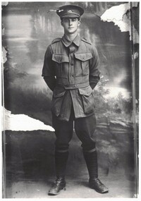 Linton and District Historical Society Inc
Photograph, Orlando Pyke
Black and white copy of original photograph showing a man wearing military uniform, standing to attention with his hands behind his back. Looks to have a scene of trees and water in the background. Some damage on the original photograph."1605 Geo (crossed out) Pyke Orlando Pyke"orlando pyke, australian imperial forces, world war i, world war 1914-1918 -
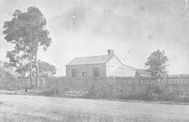 Ringwood and District Historical Society
Photograph, The Lewis Findlay East Residence, Bedford Rd, Ringwood. 1901
Black and white photograph of weatherboard house surrounded by a picket fence. (2 copies- 1 large, 1 small). Typed notes detailing history of cottage.Typed notes contain the following: "Cottage and Lot 15, Sec.C, Township of Ringwood - comprising 1 acre - were acquired from the Crown by John Price on 17th July, 1888, for £30. Subsequently, a 4-roomed weatherboard cottage was built on Lot 15. On 21st May, 1901, the two allotments and the house were transferred to Lewis Findlay East for £85, and on 13th March, 1942, were sold to R. Barr and L. Beaumont for £650 with two additional rooms and some other improvements including reticulated water supply. Lewis Findlay EAST and his family occupied the cottage until 1910. It is believed that before the cottage was purchased by East, it was occupied for a period by McCubbin the artist. Lewis Findlay East was a member of an Australian Rifle Team which went to Bisley, England, in 1901, and won the Kalapore Cup. He was an officer of the Department of Customs, and later became Secretary of the Commonwealth Marine Branch, receiving the I.S.O. His son, Lewis Ronald East, became Chairman of the State Rivers and Water Supply Commission in 1936, and received C.B.E.". -
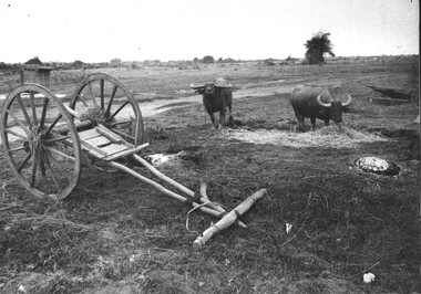 National Vietnam Veterans Museum (NVVM)
Photograph, Gibbons, Denis, Water Buffalo
Denis Gibbons (1937 – 2011) Trained with the Australian Army, before travelling to Vietnam in January 1966, Denis stayed with the 1st Australian Task Force in Nui Dat working as a photographer. For almost five years Gibbons toured with nine Australian infantry battalions, posting compelling war images from within many combat zones before being flown out in late November 1970 after sustaining injuries. The images held within the National Vietnam Veterans Museum make up the Gibbons Collection. A black and white photograph of a farmer's water buffalo raises its head into the charge position as a group of diggers pass by.photograph, gibbons collection catalogue, water buffalo, diggers, denis gibbons -
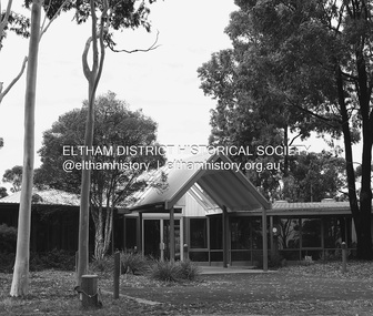 Eltham District Historical Society Inc
Photograph - Digital Photograph, Alan King, Wycliffe Centre, Graham Road, Kangaroo Ground, 2008
Wycliffe translates the Bible for people around the world. Published: Nillumbik Now and Then / Marguerite Marshall 2008; photographs Alan King with Marguerite Marshall.; p171 The peace and beauty of Australia’s Wycliffe Centre reflects what it aims to bring to thousands of people around the world. Kangaroos calmly feed, accompanied by bird song, near the mud-brick buildings set amongst Kangaroo Ground’s rolling hills. On 11 hectares off Graham Road, the centre aims to transform people’s lives by giving groups around the world, with no written language, help with literacy and Bible translation into their own tongue. Associate Director, Harley Beck, says reading the Bible (probably history’s most influential collection of books), in one’s own language, provides a strong moral basis, helping people withstand exploitation and escape poverty. One of Wycliffe’s field partners, SIL (formerly Summer Institute of Linguistics) Papua New Guinea, has won two UNESCO awards, and SIL branches in many other countries have won international and national awards. The translators are modern heroes. They undertake hardships, forsaking for years, sometimes decades, a salary and the soft western lifestyle, to face loneliness and primitive conditions that most of us would not even contemplate. No staff is paid a salary. An example is the first Australian Director and former International President, David Cummings, who for 50 years has depended on donations from supporters and churches. Students of all ages at the EQUIP Training School on the site come from all walks of life. They train in linguistics and learn how to communicate in a way that is sensitive to other cultures. Spiritual resilience is encouraged, enabling people to persist until the job in the field is done, which takes on average ten to 15 years. Courses range from a few weeks to a year. The Wycliffe concept was born in the 1920s when American missionary, Cameron Townsend, found a Spanish Bible was inadequate to evangelise the Cakchiquel people of Guatemala. When a Cakchiquel man challenged: ‘If your God is so great, why doesn’t he speak my language?’ Townsend decided to translate the Bible into all languages! He founded a linguistics training school in 1934, naming it after 14th century theologian John Wycliffe, the first to translate the Bible into English. The first Wycliffe Bible was completed in 1951 in the Mexican San Miguel Mixtec language. In May 2007 after 30 years of work, Wycliffe Australia, with other organisations, completed the first Bible for indigenous people in the Kriol* language, for about 30,000 people in northern Australia. Wycliffe Australia began in 1954 in the Keswick Bookshop basement, Collins Street, Melbourne. As the organisation grew, its quarters became so cramped that Director Cummings at times interviewed potential recruits in his car! The development of the Kangaroo Ground property is a story of faith and generosity. In 1967 Cummings proposed moving to a larger property despite having no funds. Within a month Wycliffe received a $20,000 donation and a gift of land towards a national centre. An earlier owner of the Kangaroo Ground property, Mrs Elsie Graham, would have been delighted, as she had wanted her land to be used for ‘God’s service’. Mud-brick architect and Christian, Alistair Knox, offered to design the centre at no charge. Despite a drought, straw was donated to make bricks. Many volunteers helped with the building, including church youth groups who made mud-bricks. Volunteers planted thousands of native plants, watered by recycled water from the site’s dam. Building began in 1968 and in 1983 the South Pacific SIL School (now EQUIP Training) followed. Wycliffe, the world’s largest linguistic organisation, and other organisations, have translated the Scriptures into more than 2000 languages. But another 2000 languages still lack any portion of the Bible. However translations are now completed more quickly, because of new computer programs and as education spreads, more speakers of the local language can assist. Despite the growth of secularisation, Beck says support for Wycliffe Australia, which has offices in all states and the ACT, is stronger than ever. * Kriol is a Pidgin language, which has become a speech community’s prime language.This collection of almost 130 photos about places and people within the Shire of Nillumbik, an urban and rural municipality in Melbourne's north, contributes to an understanding of the history of the Shire. Published in 2008 immediately prior to the Black Saturday bushfires of February 7, 2009, it documents sites that were impacted, and in some cases destroyed by the fires. It includes photographs taken especially for the publication, creating a unique time capsule representing the Shire in the early 21st century. It remains the most recent comprehenesive publication devoted to the Shire's history connecting local residents to the past. nillumbik now and then (marshall-king) collection, graham road, kangaroo ground, wycliffe centre -
 Eltham District Historical Society Inc
Photograph - Digital Photograph, Alan King, Blue Lake, Plenty Gorge Park, 2008
A quarry was transformed into the Blue Lake. Published: Nillumbik Now and Then / Marguerite Marshall 2008; photographs Alan King with Marguerite Marshall.; p179 The dramatic steep-sided Plenty Gorge lies along the divide of two geological areas, and separates the Nillumbik Shire and the City of Whittlesea. On the Nillumbik side are undulating hills and sedimentary rock, and in Whittlesea, lies a basalt plain formed by volcanic action up to two million years ago. This provides the Plenty Gorge Park with diverse vegetation and habitats, making it one of Greater Melbourne’s most important refuges for threatened and significant species. The park, established in 1986, consists of around 1350 hectares, and extends 11 kilometres along the Plenty River, from Greensborough to Mernda. It provides a wildlife corridor for around 500 native plant and 280 animal species. The area’s plentiful food and water attracted the Wurundjeri Aboriginal people and then European settlers. By 1837 squatters had claimed large runs of land for their sheep and cattle. The Plenty Valley was among the first in the Port Phillip District to be settled - mainly in the less heavily timbered west - and was proclaimed a settled district in 1841.But by the late 1880s, the settlers’ extensive land clearing for animal grazing, then agriculture, depleted the Wurundjeri’s traditional food sources, which helped to drive them away. Many Wurundjeri artefacts remain (now government protected), and so far 57 sites have been identified in the park, including scarred trees, burial areas and stone artefacts. Pioneer life could be very hard because of isolation, flooding, bushfires and bushrangers. Following the Black Thursday bushfires of 1851, basalt was quarried to build more fire-resistant homes. Gold discoveries in the early 1850s swelled the population, particularly around Smugglers Gully; but food production made more of an impact. In the late 1850s wheat production supplanted grazing. In the 1860s the government made small holdings available to poorer settlers. These had the greatest effect on the district, particularly in Doreen and Yarrambat, where orchards were established from the 1880s to 1914. Links with a prominent early family are the remains of Stuchbery Farm, by the river’s edge bounded by Smugglers Gully to the north and La Trobe Road, Yarrambat, to the east. The Stuchberys moved to the valley in 1890, and the family still lives in the area. In 1890, Alfred and Ada first lived in a tent where four children were born, then Alfred built the house and outbuildings around 1896. They planted an orchard, then a market garden, and developed a dairy. The family belonged to the local Methodist and tennis communities. Their grandson Walter, opened the Flying Scotsman Model Railway Museum in Yarrambat, which his widow, Vi, continues to run. Wal was also the Yarrambat CFA Captain for 22 years until 1987. Walter sold 24 hectares in 1976 for development - now Vista Court - and in 1990, the remaining 22.6 hectares for the park. Remaining are an early stone dairy and remnants of a stone barn, a pig sty and a well. Until it was destroyed by fire in 2003, a slab hut stood on the Happy Hollow Farm site, at the southern end of the park. The hut is thought to have been built in the Depression around 1893. This was a rare and late example of a slab hut with a domestic orchard close to Melbourne. Emmet Watmough and his family first occupied the hut, followed by a succession of families, until the Bell family bought it around 1948. There they led a subsistence lifestyle for 50 years, despite encroaching Melbourne suburbia. The Yellow Gum Recreation Area includes the Blue Lake, coloured turquoise at certain times of the year. Following the 1957 bushfires, this area was quarried by Reid Quarries Pty Ltd for Melbourne’s first skyscrapers, then by Boral Australia. However in the early 1970s water began seeping into the quarry forming the Blue Lake and the quarry was closed. The State Government bought the site in 1997 and opened it as a park in 1999.This collection of almost 130 photos about places and people within the Shire of Nillumbik, an urban and rural municipality in Melbourne's north, contributes to an understanding of the history of the Shire. Published in 2008 immediately prior to the Black Saturday bushfires of February 7, 2009, it documents sites that were impacted, and in some cases destroyed by the fires. It includes photographs taken especially for the publication, creating a unique time capsule representing the Shire in the early 21st century. It remains the most recent comprehenesive publication devoted to the Shire's history connecting local residents to the past. nillumbik now and then (marshall-king) collection, blue lake, plenty gorge park -
 Eltham District Historical Society Inc
Photograph - Digital Photograph, Marguerite Marshall, Stuchbery Farm dairy, 14 March 2008
Stuchbery Farm was situated on the Plenty River bounded by Smugglers Gully to the north and La trobe Road, Yarrambat, to the east. Alan and Ada Stutchbery moved to the valley in 1890, first living in a tent where four children were born. Alfred built a home and outbuildings around 1896. They planted an orchard, then a market garden and developed a dairy. Published: Nillumbik Now and Then / Marguerite Marshall 2008; photographs Alan King with Marguerite Marshall.; p179 The dramatic steep-sided Plenty Gorge lies along the divide of two geological areas, and separates the Nillumbik Shire and the City of Whittlesea. On the Nillumbik side are undulating hills and sedimentary rock, and in Whittlesea, lies a basalt plain formed by volcanic action up to two million years ago. This provides the Plenty Gorge Park with diverse vegetation and habitats, making it one of Greater Melbourne’s most important refuges for threatened and significant species. The park, established in 1986, consists of around 1350 hectares, and extends 11 kilometres along the Plenty River, from Greensborough to Mernda. It provides a wildlife corridor for around 500 native plant and 280 animal species. The area’s plentiful food and water attracted the Wurundjeri Aboriginal people and then European settlers. By 1837 squatters had claimed large runs of land for their sheep and cattle. The Plenty Valley was among the first in the Port Phillip District to be settled - mainly in the less heavily timbered west - and was proclaimed a settled district in 1841. But by the late 1880s, the settlers’ extensive land clearing for animal grazing, then agriculture, depleted the Wurundjeri’s traditional food sources, which helped to drive them away. Many Wurundjeri artefacts remain (now government protected), and so far 57 sites have been identified in the park, including scarred trees, burial areas and stone artefacts. Pioneer life could be very hard because of isolation, flooding, bushfires and bushrangers. Following the Black Thursday bushfires of 1851, basalt was quarried to build more fire-resistant homes. Gold discoveries in the early 1850s swelled the population, particularly around Smugglers Gully; but food production made more of an impact. In the late 1850s wheat production supplanted grazing. In the 1860s the government made small holdings available to poorer settlers. These had the greatest effect on the district, particularly in Doreen and Yarrambat, where orchards were established from the 1880s to 1914. Links with a prominent early family are the remains of Stuchbery Farm, by the river’s edge bounded by Smugglers Gully to the north and La Trobe Road, Yarrambat, to the east. The Stuchberys moved to the valley in 1890, and the family still lives in the area. In 1890, Alfred and Ada first lived in a tent where four children were born, then Alfred built the house and outbuildings around 1896. They planted an orchard, then a market garden, and developed a dairy. The family belonged to the local Methodist and tennis communities. Their grandson Walter, opened the Flying Scotsman Model Railway Museum in Yarrambat, which his widow, Vi, continues to run. Wal was also the Yarrambat CFA Captain for 22 years until 1987. Walter sold 24 hectares in 1976 for development - now Vista Court - and in 1990, the remaining 22.6 hectares for the park. Remaining are an early stone dairy and remnants of a stone barn, a pig sty and a well. Until it was destroyed by fire in 2003, a slab hut stood on the Happy Hollow Farm site, at the southern end of the park. The hut is thought to have been built in the Depression around 1893. This was a rare and late example of a slab hut with a domestic orchard close to Melbourne. Emmet Watmough and his family first occupied the hut, followed by a succession of families, until the Bell family bought it around 1948. There they led a subsistence lifestyle for 50 years, despite encroaching Melbourne suburbia. The Yellow Gum Recreation Area includes the Blue Lake, coloured turquoise at certain times of the year. Following the 1957 bushfires, this area was quarried by Reid Quarries Pty Ltd for Melbourne’s first skyscrapers, then by Boral Australia. However in the early 1970s water began seeping into the quarry forming the Blue Lake and the quarry was closed. The State Government bought the site in 1997 and opened it as a park in 1999.This collection of almost 130 photos about places and people within the Shire of Nillumbik, an urban and rural municipality in Melbourne's north, contributes to an understanding of the history of the Shire. Published in 2008 immediately prior to the Black Saturday bushfires of February 7, 2009, it documents sites that were impacted, and in some cases destroyed by the fires. It includes photographs taken especially for the publication, creating a unique time capsule representing the Shire in the early 21st century. It remains the most recent comprehenesive publication devoted to the Shire's history connecting local residents to the past. nillumbik now and then (marshall-king) collection, ada stuchbery, alan stuchbery, dairy, stuchbery farm, farm buildings, yarrambat, plenty gorge park -
 Eltham District Historical Society Inc
Photograph - Digital Photograph, Alan King, Diamond Creek, Barak Bushlands, Eltham, 2008
A habitat corridor and it strengthens the community. Published: Nillumbik Now and Then / Marguerite Marshall 2008; photographs Alan King with Marguerite Marshall.; p185 Barak Bushlands lie west of the Diamond Creek on the corner of Falkiner Street and busy, noisy Main Road. They form part of an important habitat corridor linking the Yarra River to the Kinglake National Park.1 Manna Gums, tawny frogmouths and platypuses are some of the indigenous plants and animals that have made their home there. The bushlands are the result of more than nine years of hard work by the local community with the Nillumbik Council, to transform a degraded flood plain into this refuge of natural beauty. In 1997, shortly after moving into the new Riverside Estate on Falkiner Street, Eltham, several residents noticed the sorry state of the Diamond Creek and surrounding area. Part of it was used as a cow paddock and although small patches of vegetation survived, the area was infested with weeds, rabbits, rubbish and drainage from the housing estate. At various times the 4.4 hectares had been used as a market garden and for shire stock piles. The residents began to restore the area by revegetating land along the Diamond Creek. In 1998 they established the Friends of the Diamond Creek Falkiner Street Reserve2 and 35 families joined from the 90-house Estate. Carolyn Mellor, as the Friends’ Land Manager, undertook a four-year horticulture course to guide this massive project for a volunteer organisation. Since 1999, she has been the Friends’ President. In 1999 the Friends urged the Nillumbik Council to undertake a feasibility study into establishing a wetland system and urban forest. Work began in 2002 with Nillumbik Council funding the project, supplemented by government grants. The Friends also received grants from Melbourne Water and Parks Victoria. Aided by the Friends and other community members, the Council created the Barak Bushlands consisting of a forest, a wetland, a bridge, a path and open space. The beautiful wetland treats most of the estate’s stormwater runoff. Storm water is filtered through plants in the wetland ponds then is released slowly into the billabong, before flowing into the Diamond Creek. The wetland also helps to minimise flooding and the improved water quality provides a flora and fauna habitat. The Friends and other volunteers planted more than 27,000 plants, more than one third of which they grew from seeds they collected at Lower Eltham and Wingrove Parks. Eltham High School students planted thousands of these through a Year Eight program introduced for this purpose. Other groups who assisted were: Green Corps, local Scouts and Guides – 2nd Montmorency, 1st Diamond Creek and 1st Eltham Cub Packs, Eltham College students, Eltham East Primary School, Landcare members, Eltham Lions Club and the Eltham Baptist Church. To maintain enthusiasm for the mammoth task, the Friends and other volunteers ‘adopted’ trees to water and wrote their names on the stakes. In 2004, to recognise the area’s original occupiers, the reserve was named Barak Bushlands. William Barak, who lived from 1824 to 1903, was the last chief of the Yarra Yarra tribe of the Wurundjeri-willam people. Traces of these original inhabitants remain in scar trees (bark sections removed to make a shield or canoe). That same year the Friends’ group was a finalist in the prestigious Federal Government, Banksia Environmental Awards. The Friends have also participated in Clean Up Australia, removing tonnes of rubbish and regularly testing the billabong, wetland and creek, for pollutants. For years the Friends, together with the Australian Platypus Conservancy, have tagged, measured and checked the health of platypuses from the Diamond and Mullum Mullum Creeks. With Latrobe University the Friends have conducted night walks to view owls, possums, bats and sugar gliders. Challenges for the council and the Friends continue with a large rabbit population, some vandalism, weed eradication and maintenance. However, thanks to this community effort, locals can now escape confined urban living on small blocks of land and enjoy the beauty of indigenous plants and animals. Working together has also strengthened the local community,This collection of almost 130 photos about places and people within the Shire of Nillumbik, an urban and rural municipality in Melbourne's north, contributes to an understanding of the history of the Shire. Published in 2008 immediately prior to the Black Saturday bushfires of February 7, 2009, it documents sites that were impacted, and in some cases destroyed by the fires. It includes photographs taken especially for the publication, creating a unique time capsule representing the Shire in the early 21st century. It remains the most recent comprehenesive publication devoted to the Shire's history connecting local residents to the past. nillumbik now and then (marshall-king) collection, barak bushlands, diamond creek (creek), eltham -
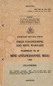 National Vietnam Veterans Museum (NVVM)
Booklet, Australian Army, Australian Army: Field Engineering And Mine Warfare, Pamphlet No. 10: Mine Anti-personnel M18A1 (Claymore), 1970
A blue coloured back cover with the front cover which has rutned to a brownish colour with some blue at the bottom of the cover and it looks like possible water marks on the cardboard cover. Top right hand side reads DSN 7610-66-034-5750. There are two punch holes down the left hand side of the booklet.australia - armed forces - service manuals, australina military forces, field engineering, mine warfare, mine "anit-personnell m18a1, claymore mine -
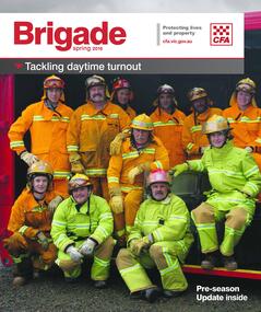 Falls Creek Historical Society
Magazine - Brigade Magazine Spring 2016
Brigade Magazine is issued to members of the Victorian CFA. The Spring edition of 2016 includes an article to acknowledge 21 years of service by the Falls Creek CFA. The article was written by Joy Nowakowski on behalf of the Falls Creek CFA with information provided by the Falls Creek Historical Society. Falls Creek Fire Brigade protects Falls Creek Village from fires throughout the year and supports other brigades to fight bushfires nearby and further away. In 2016 the brigade had 23 year-round volunteers. At a celebratory function at Falls Creek in June 2016, alpine pumper and brigade snowmobiles were on display. Falls Creek’s alpine pumper was the first of its kind in Australia. It had a pumping capacity of 4,000 litres a minute and its tracks enabled it to access areas of the village and ski fields. Until 2016 Falls Creek Village has been threatened by two major fires, the worst being in 2003 when CFA crews saved the village and the adjoining ski field infrastructure right at the boundaries. Snow making equipment was used to create a water/fog barrier that helped stop the fires from taking the village. The team that saved the village was considered heroic Support for fighting fires at Falls Creek dates back to 1956 but this support came from Mount Beauty, 30 kilometres down the mountain. Falls Creek locals were concerned by this, so used six available hydrants and a canvas hose to fight any fires on the mountain. In 1964 the SECV gave the village a trailer which could be used with both wheels and skis for summer and winter operations. But this trailer only lasted two years. In the early 1970s, the village was given a 2,000-gallon Ford Blitz 4WD truck, and additional equipment was quickly acquired by the village including a new locally-constructed trailer with a pumper unit. In the 1990s, a change in land status meant the Falls Creek area became the responsibility of CFA. This status was formalised in 1995 by a public meeting that formed Falls Creek Fire Brigade.This magazine is significant because it contains an article celebrating 21 years of Falls Creek CFA.A publication for CFA members which includes stories about recent incidents, brigades, training, events, community safety, health and safety and general CFA news. falls creek cfa, alpine firefighting, falls creek cfa 21 years -
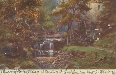 Bendigo Historical Society Inc.
Postcard - Alice McGregor Postcard Collection, 1900 - 1920
Alice McGREGOR Born: 1908; unknown parents. Possibly adopted by the Salter family? Electoral Roll 1936: Highland Terrace Kangaroo Flat. Alice Mary Salter and William Robert Salter living together; presumed to be sister and brother. William Robert Salter was killed in a MVA in Bendigo in 1937 aged 26. In Victoria in 1938, Alice Mary Salter married James Thomas McGregor (born Victoria 1917, died Victoria 1983, buried Fawkner Cemetery) Lived: 1968; 22 Wade Street Golden Square Alice McGregor Died: 1999 aged 91 at Anne Caudle Centre, Bendigo Buried: Kangaroo Flat Cemetery See additional research. Postcard Album of Alice McGregor contained 86 post cards.Postcard Album of Alice McGregor containing 86 post cards. See 1400. Colour photo of Whitby Rigg Mill in a forest. Water wheel and mill building beside a stream with small waterfalls. Addressed to Miss A. Stapleton, Arcade, Bendigo, Victoria Australia Sender - Miss R M Billing, 12 Strand St., East London, West S. Africa. Undated postcard, collector, alice mcgregor -
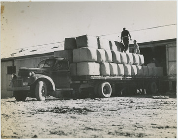
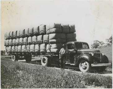 National Wool Museum
Photograph - Transporting Wool, 1960s
One of fifty one photographs originally in a photo album found in the National Wool Museum’s office. The album was water damaged and the images were removed for conservation. The images follow the process of wool. Beginning in a sheep paddock and finishing as a folded fabric. It includes all the steps in between in this process, including shearing, transporting, selling, washing and the many different steps in the process of turning a single thread of wool into fabric.Black and white image showing a man standing in front of a truck loaded with wool bales. The bales are being transported from Boorowa to Sydney.AUSTRALIAN NATIONAL PUBLICITY / ASSOCIATION / FLINDERS STREET RAILWAY BUILDING, / MELBOURNE AUSTRALIA / W40. Seventy bales of Wool going by motor vehicle from Boorowa to / Sydney.wool industry, working life, women, boonoke station, farming, sheep farming, agriculture, sheep stations, transport, wool processing, shearing, textile industry, wool -
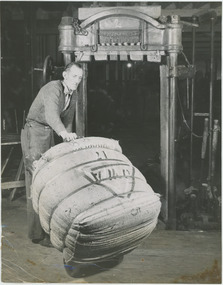
 National Wool Museum
Photograph - Loading Wool Bales, 1960s
One of fifty one photographs originally in a photo album found in the National Wool Museum’s office. The album was water damaged and the images were removed for conservation. The images follow the process of wool. Beginning in a sheep paddock and finishing as a folded fabric. It includes all the steps in between in this process, including shearing, transporting, selling, washing and the many different steps in the process of turning a single thread of wool into fabric.Black and white image showing two men loading wool bales onto a motor transport vehicle.AUSTRALIAN NATIONAL PUBLICITY / ASSOCIATION / FLINDERS STREET RAILWAY BUILDING, / MELBOURNE AUSTRALIA / W68 / W68. Loading wool bales on to / a motor transport.wool industry, working life, women, boonoke station, farming, sheep farming, agriculture, sheep stations, transport, wool processing, shearing, textile industry, wool -
 National Wool Museum
Photograph - Wheeling Away for Dispatch, 1960s
One of fifty one photographs originally in a photo album found in the National Wool Museum’s office. The album was water damaged and the images were removed for conservation. The images follow the process of wool. Beginning in a sheep paddock and finishing as a folded fabric. It includes all the steps in between in this process, including shearing, transporting, selling, washing and the many different steps in the process of turning a single thread of wool into fabric.Black and white image showing a man with a wool bale on a trolley.AUSTRALIAN NATIONAL PUBLICITY / ASSOCIATION / FLINDERS STREET RAILWAY BUILDING, / MELBOURNE AUSTRALIA / W8 / W8. Wheeling away for despatch.wool industry, working life, women, boonoke station, farming, sheep farming, agriculture, sheep stations, transport, wool processing, shearing, textile industry, wool -
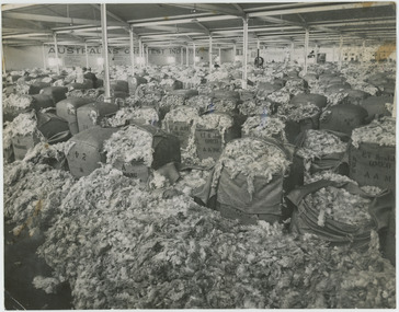 National Wool Museum
Photograph - Wool Displayed, 1960s
One of fifty one photographs originally in a photo album found in the National Wool Museum’s office. The album was water damaged and the images were removed for conservation. The images follow the process of wool. Beginning in a sheep paddock and finishing as a folded fabric. It includes all the steps in between in this process, including shearing, transporting, selling, washing and the many different steps in the process of turning a single thread of wool into fabric.Black and white image showing interior view of wool bales on display.AUSTRALIAN NATIONAL PUBLICITY / ASSOCIATION / FLINDERS STREET RAILWAY BUILDING, / MELBOURNE AUSTRALIA / W1 / W1. Wool displayed.wool industry, working life, women, boonoke station, farming, sheep farming, agriculture, sheep stations, transport, wool processing, shearing, textile industry, wool -
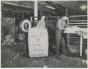 National Wool Museum
Photograph - Weighing Bales, 1960s
One of fifty one photographs originally in a photo album found in the National Wool Museum’s office. The album was water damaged and the images were removed for conservation. The images follow the process of wool. Beginning in a sheep paddock and finishing as a folded fabric. It includes all the steps in between in this process, including shearing, transporting, selling, washing and the many different steps in the process of turning a single thread of wool into fabric.Black and white image showing two men weighing a bale of wool.AUSTRALIAN NATIONAL PUBLICITY / ASSOCIATION / FLINDERS STREET RAILWAY BUILDING, / MELBOURNE AUSTRALIA / W5 / W5. Weighing bales.wool industry, working life, women, boonoke station, farming, sheep farming, agriculture, sheep stations, transport, wool processing, shearing, textile industry, wool