Showing 27609 items
matching yarra-river
-
 Eltham District Historical Society Inc
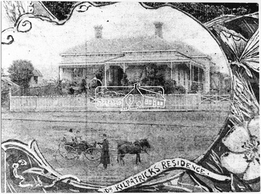
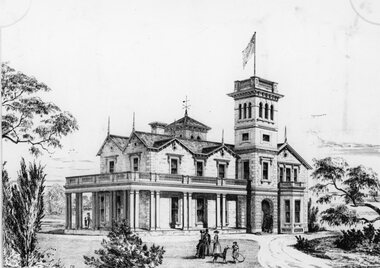
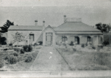
Photograph, Dr. Kilpatrick's Residence, Yarra Glen, 1893 (reproduced from "The Leader", Jan. 6th, 1894, page 31), 1894
Illustrative photograph of Dr. Kilpatricks residence at Yarra Glen. Reproduced as one of a montage in "The Leader" January 6th, 1894 page 31. The house is fenced with an established front garden. A horse and cart and people pose in the foreground. Dr. William Kilpatrick was in practice around Yarra Glen & Lilydale during the late 1880s - 90s. He married Honorah Farrell, the daughter of the local publican and a son, William was born to them in Omeo, 1906. He died in Castlemaine in 1925 Source: Mrs. E.W. Motschall (nee Marjorie Smith), Long Gully Road, Panton HillThis photo forms part of a collection of photographs gathered by the Shire of Eltham for their centenary project book,"Pioneers and Painters: 100 years of the Shire of Eltham" by Alan Marshall (1971). The collection of over 500 images is held in partnership between Eltham District Historical Society and Yarra Plenty Regional Library (Eltham Library) and is now formally known as the 'The Shire of Eltham Pioneers Photograph Collection.' It is significant in being the first community sourced collection representing the places and people of the Shire's first one hundred years.Digital imagesepp, shire of eltham pioneers photograph collection, yarra glen, cave hill, dr. kilpatrick, "the leader" -
 Orbost & District Historical Society
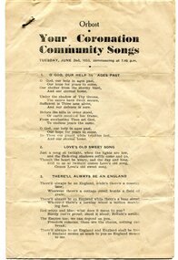
program, 1953
This program was produced by the Snowy River Mail for a community singalong held in Orbost on Tuesday June 2 1953 to celebrate the coronation of Queen Elizabeth 11. In June 1953 , Elizabeth II was crowned Queen of the United Kingdom, Canada, Australia, New Zealand, South Africa, Ceylon (now Sri Lanka), and Pakistan, and became the Head of the Commonwealth. The coronation of Queen Elizabeth II as monarch took place on 2 June 1953. Elizabeth ascended the throne at the age of 25, upon the death of her father, King George VI, on 6 February 1952, and was proclaimed queen by her various privy and executive councils shortly afterwards. The coronation took place more than a year later because of the tradition that holding such a festival is inappropriate during the period of mourning that follows the death of a monarch. This community event was typical of the general feeling of respect and admiration felt by the rural communities towards the British Royal Family. This item reflects the significance of monarchy for Australia and the constitutional history of Australia.The item reflects the interest in the royal family to Australians at this time as well as the general feeling of respect and admiration felt by the rural communities towards the British Royal Family.A white paper program with the words of songs printed in black. There is a rust mark from a metal staple in the top left corner. It is titled "Your Coronation Community Songs".queen-elizabeth-11 royalty community-event-orbost souvenir-program -
 Orbost & District Historical Society
black and white photograph, October 4 1978
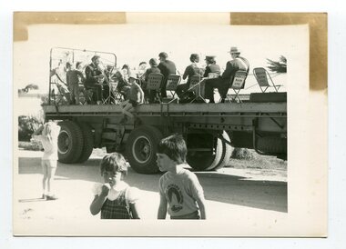
From the Snowy River Mail October 4 1978 page 9 - " A MOBILE BAND - Although Orbost Municipal Band participated in Saturday's Primary School workathon, members feet didn't touch the ground. They idi it bthe easywayon the trailer of a truck. The band encouraged walkers with stirring music along the road to Marlo." The first Orbost Brass Band was formed in 1889. Around 1908 the town band split and the Orbost Workers' Band was formed. Eventually the two bands merged in 1913 to reform as the Orbost Municipal Band under conductorship of Charles Spink. The band continued for many years but was later disbanded and again reformed. This was to happen a number of times, the last time being in 1961 and continuing through to the late 1970's. Further info and Ref: In Times Gone By - Deborah Hall This is a pictorial record of the Orbost Municipal Band. The various Orbost bands over the years played a major role in community activities providing entertainment and musical experiences for the many members.A black / white photograph showing a group of uniformed band members sitting on folding chair s on the tray of a large flat bed truck. They are holding musical instruments. A young boy is sitting on the edge of the tray and three other children are standing on the road nearby.on back - information from S.R.M.music orbost-municipal-band entertainment recreation -
 Greensborough Historical Society
Photograph - Digital Image, Blackjack: Greensborough flats and house on the Plenty River, 1953_
Greensborough flats and house on the Plenty River at Blackjack, the home of the Robinson family to late 1956. The Blackjack property, house and acres of fruit orchards ran down to the Plenty River off Hume Street Greensborough. The photographs were taken as slides by Frank Robinson and digitised by his son James in 2015.Digital copy of colour photograph.blackjack, robinson family, plenty river -
 Greensborough Historical Society
Report, Examining Draughtsman's Report - Watts River Aqueduct, 20/07/1897
This Field Survey was commissioned by the Melbourne Board of Works and was used to position the Maroondah Aqueduct bridge north of Greensborough at its crossing point on the Plenty River. It incorporated the use of wrought iron water pipes and therefore is of lighter construction than other similar bridges in the district. It features a traverse of the Plenty RiverThe Maroondah Aqueduct bridge is a significant example of late 19th century engineering. A 4 page reproduction of an Office of Titles document. Copy of handwritten report includes maps.maroondah aqueduct, watts river aqueduct, bridge, greensborough, office of titles, 1897, wrought iron water pipes, plenty river, melbourne board of works -
 Melbourne Tram Museum
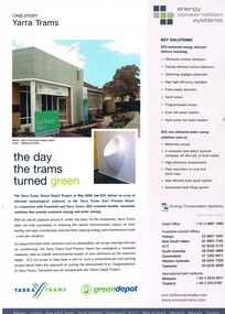
Pamphlet, Energy Conservation Systems, "Case Study Yarra Trams", May. 2005
Pamphlet - A4 full colour printed on white paper, titled "Case Study Yarra Trams" with sub-title "the day the trams turned green" about the installation of environmental friendly installations at East Preston Depot, solar panels, part of the Green Depot project, May 2005. Published by Energy Conservation Systems. Water saving systems etc. Two copies held.trams, tramways, yarra trams, east preston depot -
 Greensborough Historical Society
Photograph - Digital image, Frank Robinson, Greensborough near Plenty River bridge and football ground, 1954_
Greensborough near Plenty River bridge and football ground. The Blackjack property, house and acres of fruit orchards ran down to the Plenty River off Hume Street Greensborough and was the home of the Robinson family to late 1956. The photographs were taken as slides by Frank Robinson and digitised by his son James in 2015.Digital copy of colour photograph.robinson family, plenty river, blackjack -
 Greensborough Historical Society
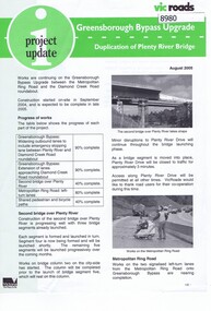
Newsletter, Vic Roads, Vic Roads , Greensborough Bypass Upgrade - Duplication of Plenty River Bridge, August 2005
Vic Roads Newsletter regarding the Greensborough Bypass Upgrade and duplication of the Plenty River Bridge.2 page Newsletter with print and black & white photosgreensborough bypass, vicroads, plenty ri, plenty river bridge -
 Greensborough Historical Society
Slide - Photograph, John Ramsdale, Plenty River: Slide 19, 1990s
Photograph shows low water flow on the Plenty River near South Morang or Mernda.Part of the John Ramsdale collection of slides and audio visual material.Colour photograph scanned from slide.No maker's marks. No caption on slide.south morang, mernda, plenty river -
 Greensborough Historical Society
Photograph - Digital image, Jessie and Gordon Scholes with Tom Vickers, Plenty River, 1943c
Photograph of Jessie Scholes (nee Partington), Gordon Scholes and Tom Vickers at the Plenty River.Digital copy of black and white photograph.jessie scholes, jessie partington, gordon scholes, tom vickers, plenty river -
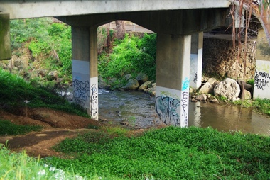 Greensborough Historical Society
Photograph - Digital image, Marilyn Smith, Railway Road Rail Bridge over Plenty River Briar Hill, 17/09/2014
Para Road bridge over Plenty River Greensborough, showing graffiti on bridge supports.Digital copy of colour photographpara road greensborough, plenty river -
 Stawell Historical Society Inc
Drawing, "Woodlands" Homestead on Wimmera River near Crowlands -- Drawing
Drawing of Woodlands Homestead on Wimmera River near Crowlands the seat of John Wilson Esqstawell -
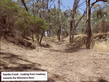 Stawell Historical Society Inc
Photograph, Swedes Creek Looking looking towards the Wimmera River 2017 -- Coloured
Colour Photo of Swedes Creek Looking from roadway towards the Wimmera River 2017water -
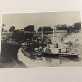 Port of Echuca
Black and white copy of a photograph of steam boats on the Darling River in 1902, Paddle steamers on the Darling River at Wilcannia in 1902, 19/09/1984
Original photograph held by Helen Coulson. A copy is also held by the National Library. 1902 was a drought year. Compare the water levels with that of the same view in P000012. 'P. S Wandering Jew' was built in Victoria in 1866. ( Ref; "The Register of Australian and N.Z Shipping." By C.Earnshaw. Page 136.This photo is significant because it shows the extent of the 1902 drought. It also shows the type of cargo carried in barges, and also the techniques used to unload the cargo. It also show the difference between stern wheelers and side wheeler paddle steamers. It also shows the length nod the height of the bridge at Wilcannia to cope with high and low water levels.A copy of a black and white photograph taken in 1902. It shows 8 paddle steamers and 4 barges under a bridge over the Darling River near Wilcannia in N.S.W. Cargo is being unloaded onto the left bank. Two barges are also tied up on the right bank.Written on the back in pencil " see photo P000012 and P000014.1drought, 1902, darling river, paddle steamers, barges, cargo, river trade, murray darling river basin, irrigation, wilcannia -
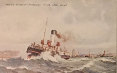 Kew Historical Society Inc
Postcard, Valentine's Series, River Mersey - Through Wind and Wave, c.1928
Collection of thirty-nine postcards donated by Jillian Rigby which had been owned by her grandparents, George and Edith Weir, who from c.1917 lived at 84 Princess Street, Kew. The mostly 'mint' postcards were purchased in Victoria and while travelling overseas. The sole dated postcard is dated from 1929. The postcards are numbered sequentially from 2017.0058.01-39. The remainder of the collection donated by Jill Rigby which was once owned by the Weirs of Broken Hill and Kew consist of costumes, costume accessories, photographs, and documents.The postcards in the Weir collection, especially those purchased on a trip or trips to the mother country, i.e. United Kingdom, represent a representative sample of sites that were considered significant to those Australians undertaking a reverse grand tour by member of the erstwhile colonies. Those postcards which are early views of Melbourne must have been produced commercially for some decades from the early part of the 20th century.River Mersey - Through Wind and Wave. One of a set of three [originally six] 'High Class Postcards of Memories of the Mersey, Beautifully Reproduced in Nature Colours', in their original brown envelope.The postcard was probably purchased by George and Edith Weir on a trip to England and Scotland, circa 1928. postcards, george and edith weir, river mersey, postcards -- england (uk), weir collection -
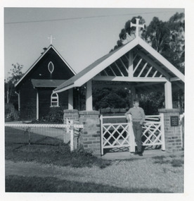 Lakes Entrance Regional Historical Society (operating as Lakes Entrance History Centre & Museum)
Photograph, 1964
Church was licensed and dedicated 29 February 1928.Small format black and white photograph of St John the Evangelist Anglican Church, Cann River, which shows a dark, possibly oil stained timber building with high pitched gable roof, and skillion porch. Entry to property is through lich-gate set of brick pillars. Boy standing at gate Russell Soderlund. Cann River Victoriareligion, buildings -
 Wonga Park Community Cottage History Group
Photograph (sub-item) - ‘Forest Gate’, first part built in 1890s, substantially enlarged prior to 1910. Now known as ‘White Lodge’, still stands today (1895) in Yarra Road, but parts have since been rebuilt and altered
‘Forest Gate’, first part built in 1890s, substantially enlarged prior to 1910. Now known as ‘White Lodge’, still stands today (1895) in Yarra Road, but parts have since been rebuilt and altered. -
 Melbourne Tram Museum
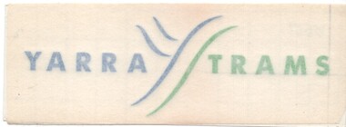
Sign - Adhesive label, Yarra Trams, c2003
Adhesive Label or Signs with the Yarra Trams logo in blue and green of the type with an adhesive front type to enable it to placed on a window, printed on paper with a ruled back. 3 copies held.trams, tramways, yarra trams, signs, tramcars -
 Melbourne Tram Museum
Sign - Adhesive label, Yarra Trams, "Caution Watch Your Step", c2010
Adhesive label for fitting to trams operated by Yarra Trams, asking passengers to "Caution Watch Your Step" - has a reflective letters on a green background. Printed on Avery adhesive paper.trams, tramways, signs, tramcars, yarra trams -
 Greensborough Historical Society
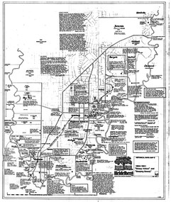
Map, Heidelberg: Historic River Landscape Assessment. Historical maps. Map D 1864 -1901 "Sleepy Hollow" and "Sleeping beauty", 1985c
Geographical area of c. 35 sq. kilometres marked with physical features such as major roads, rivers, vegetation and properties, with locations and notes on the increasing number of farms, orchards and vineyards that had been developed in addition to pastoral runs. Bounded by Shire of Diamond Valley to the North, Darebin Creek to the West, and Plenty River to the East.Black and white sketch on white paper. Second copy 600 x 430 cm printed in black on semi-opaque paperheidelberg, heidelberg - maps -
 Greensborough Historical Society
Photograph - Digital image, Frank Robinson, Looking across the Plenty River from Pope's paddock to Blackjack, 1954_
Looking across the Plenty River from Pope's paddock to Blackjack. The Blackjack property, house and acres of fruit orchards ran down to the Plenty River off Hume Street Greensborough and was the home of the Robinson family to late 1956. The photographs were taken as slides by Frank Robinson and digitised by his son James in 2015.Digital copy of colour photograph.blackjack, popes paddock, robinson family -
![Junction of the River Watt and Contentment Creek / [by] Nicholas Caire, circa 1876](/media/collectors/550653872162f11fb04854aa/items/57760437d0cdd10a5c49fc3e/item-media/57760510d0cdd10a5c4a8f9c/item-fit-380x285.jpg) Kew Historical Society Inc
Kew Historical Society IncPhotograph, Anglo-Australasian Photographic Company, Junction of the River Watt and Contentment Creek, c. 1876
Nicholas Caire was born on Guernsey in the Channel Islands in 1837. He arrived in Adelaide with his parents in about 1860. In 1867, following photographic journeys in Gippsland, he opened a studio in Adelaide. From 1870 to 1876 he lived and worked in Talbot in Central Victoria. In 1876 he purchased T. F. Chuck's studios in the Royal Arcade Melbourne. In 1885, following the introduction of dry plate photography, he began a series of landscape series, which were commercially successful. As a photographer, he travelled extensively through Victoria, photographing places few of his contemporaries had previously seen. He died in 1918. Reference: Jack Cato, 'Caire, Nicholas John (1837–1918)', Australian Dictionary of Biography.An original, rare photograph from the series 'Views of Victoria: General Series' by the photographer, Nicholas Caire (1837-1918). The series of 60 photographs that comprise the series was issued c. 1876 and reinforced a neo-Romantic view of the Australian landscape to which a growing nationalist movement would respond. Nicholas Caire was active as a photographer in Australia from 1858 until his death in 1918. His vision of the Australian bush and pioneer life had a counterpart in the works of Henry Lawson and other nationalist poets, authors and painters.Albumen Silver Photograph, mounted on Board. printed in ink on support l.c.: JUNCTION OF THE RIVER WATT AND CONTENTMENT CREEK. / COPYRIGHT REGISTERED. printed in ink on support reverse c.: VIEWS OF VICTORIA. / (GENERAL SERIES.) / No. 1. / JUNCTION OF THE RIVER WATT AND CONTENTMENT CREEK. / This scene is situated about two miles to the westward of Fernshawe, a small but extremely romantic township. / The river, at this juncture, is crossed by a fallen tree, as may be seen in the illustration. The track which is seen on / the opposite side of the river leads to the summit of Mt. Munda (3,500 feet high), 4 miles distant, from which place / visitors can see the Australian Alps, in all their mighty grandeur, stretching for hundreds of miles on either side, / and, as far as the eye can reach, impressing a beholder with the appropriateness of their title, being that of the Great Dividing Range. printed in ink on support reverse l.c.l.: J.W. FORBES, Agent, printed in ink on support reverse l.c.: ANGLO-AUSTRALASIAN PHOTOGRAPHIC COMPANY, MELBOURNE. printed in ink on support reverse l.c.r.: 10 Temple Court, Collins Street West.nicholas caire, views of victoria - general series, landscape photography -
 Eltham District Historical Society Inc
Folder, Shire of Eltham Pioneers Photograph Collection; Application by Yarra Plenty Regional Library for a Local History Grant to digitise collection, 1982-2014
Material pertaining to the production of a history of the Shire of Eltham, "Pioneers & Painters: One Hundred Years of Eltham and its Shire" in recognition of the shire's centenary in 1971 Item Title Caption 04771-1 Shire of Eltham Pioneers Photograph Collection: Application; Local History Grants Program 2012-2013, Yarra Plenty Regional Library, 7 November 2012 04771-2 Shire of Eltham Pioneers Photograph Collection: Local History Grants Program 2012-2013, Yarra Plenty Regional Library, 31 May 2013 04771-3 Notification to Eltham District Histoprical Society of successful application for Local History Grants Program by Yarra Plenty Regional Library, 5 June 2013 04771-4f 04771-5 Media Release, Craig Ondarchie MP announcing a grant of $3,775 for the Shire of Eltham Pioneers Photograph Collection, 3 July 2013 Grant for digitising selected images within the collection 04771-6 Details of negative and prints scanned as part of Local History Grants Project, 23 October 2013 04771-7 Feedback from Eltham Disitrict Historical Society to Local and Family History Librarian, Yarra Plenty Regional Library in support of Local History Grant application to digitise the Shire of Eltham Pioneers Photograph collection, 27 October 2012. The idea to develop a book on the history of the Shire of Eltham to be edited by noted author, Alan Marshall in celebration of the shire's centenary was initiated in 1969. The Shire of Eltham Historical Society undertook significant research in conjunction with Alan Marshall locating material at various institutions and other societies; interviewing longer term residents and a public campaign through the local press to acquire photographic material for duplication and use in the book. The public campaign received generous response and the material collected became the genesis for the Shire of Eltham Pioneers Photograph collection now held in partnership between Eltham District Historical Society and Yarra Plenty Regional Library (Eltham Library). This material covers the application to digitise the bulk of the collection with the assistance of a Local History Grants project made available through Public Records Office Victoria; the result of which was successful and has enable d Eltham District Historical Society and Yarra Plenty Regional Library to embrace a much wider audience from far afield in sharing the local history of the Eltham Shire and Eltham districtPaper documents A4 size; one item laminatedeltham district historical society, local history grants program 2012-2013, public record office victoria (prov), yarra plenty regional library, shire of eltham pioneers photograph collection -
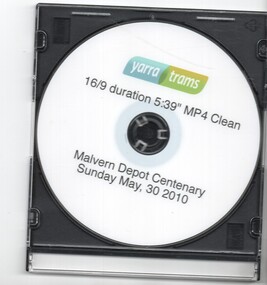 Melbourne Tram Museum
Film - Compact Diskette with video, Yarra Trams, "Malvern Tram Depot Centenary Celebration 30 May 2010", Jun. 2010
Compact Diskette with video (DVD), titled "Malvern Tram Depot Centenary Celebration 30 May 2010" - in a clear covered plastic case with a black back. "Celebrations" running time 5mins, 40secs, gives an introduction to the PMTT, Yarra trams celebrations, includes interview with Craig Tooke (COTMA), Ian Stimpson of Bendigo trams, images of 44 and 84 running in and out of the depot, speech by Michel Masson, CEO of Yarra Trams, Brian Tee, Parliamentary Secretary for Transport, historic footage of the 1910 Opening of Malvern depot. Same as chapter 1 of Reg item 925. Printed on the top of the DVD is the Yarra Trams logo, "16/9 duration 5:39" MP4 Clean"trams, tramways, pmtt, opening, yarra trams, malvern depot, centenaries -
 Melbourne Tram Museum
Pamphlet, Yarra Trams, "Short Trip Ticket Information", Feb. 2003
Booklet - 16 pages, center stapled with route tabs, printed in colour on gloss paper, titled "Short Trip Ticket Information", effective Feb. 2003. Outlines the use of Yarra Tram's short trip tickets on the tramway system, and gives details of 7 routes and section details with a map at the time. Second copy added 23-10-15 from Yarra Trams donation. .1 - 12 pages, centre stapled, printed on white paper, titled "Short Trip Tickets", giving information for routes 11, 12, 48, 70, 75, 86, 96, and 109. Has a map for each route and trip information, Metcards. C2001, prior the amalgamation of Yarra and M>Tram.trams, tramways, the met, short trip tickets, tickets, instructions, yarra trams, route 12, route 11, route 48, route 70, route 75, route 86, route 96, route 109 -
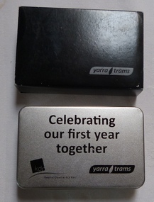 Melbourne Tram Museum
Decorative Object - Gift Box, Yarra Trams, "Celebrating our first year together", Dec. 2010
Metal gift box or tin, contained within a black card cover with Yarra Trams name on the outside. The Gift box or tin, with lid, has the words "Celebrating our first year together", with the Keolis Downer EDI Rail logo and Yarra Trams logo. The box contains a silver coloured metal torch, with LED bulbs fitted with a cotton hand strap. Three AAA size batteries by Ninghai Hengjui Battery Co. contained within the dark grey foam holder. The torch has been printed with the Yarra Trams logo. Folded with in the box is a 10 folded card giving the achievements of the first year (from 30 Nov. 2009) to Nov. 2010. Printed in full colour.trams, tramways, yarra trams, tramtracker, myki, keolis -
 Greensborough Historical Society
Photograph - Digital image, Frank Robinson, Looking north over the football ground with bridge over Plenty River, 1954_
Looking north over the football ground with bridge over Plenty River. The Blackjack property, house and acres of fruit orchards ran down to the Plenty River off Hume Street Greensborough and was the home of the Robinson family to late 1956. The photographs were taken as slides by Frank Robinson and digitised by his son James in 2015.Digital copy of colour photgraph.robinson family, blackjack, plenty river -
 Greensborough Historical Society
Slide - Photograph, John Ramsdale, Ford over Plenty River to Partington's Flat: Slide 72, 1990s
Photograph shows road or path over culvert. This is the ford over Plenty River to Partington's FlatPart of the John Ramsdale collection of slides and audio visual material.Colour photograph scanned from slide.No caption. Printed maker's mark on slide "Kodak Kodachrome Slide"ford over plenty river, plenty river, partington's flat -
 Greensborough Historical Society
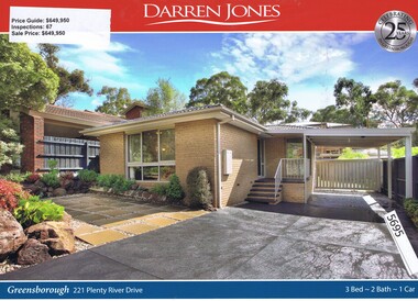
Advertising Leaflet, Darren Jones, 221 Plenty River Drive Greensborough, 13/05/2017
221 Plenty River Drive Greensborough. Three bedroom house, sold for $649,950 in July 2017. Real estate advertising leaflet, 1 sheet, printed in colour both sides. plenty river drive greensborough -
 Greensborough Historical Society
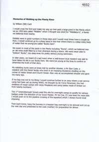
Document, Bill Cecil, Memories of walking up the Plenty River, by William (Bill) Cecil, 1950o
Bill Cecil remembers activities from his youth including rabbit hunting on the Plenty River1 page, typescriptplenty river, bill cecil