Showing 123782 items matching "main-road"
-
 Sunshine and District Historical Society Incorporated
Book, Sunshine High School Prefects between 1958 and 1971, Prefects Pledge - SUNSHINE HIGH SCHOOL, 1958 to 1971
Sunshine High School had the system of Prefects being elected by the students from candidates nominated by the teachers. It is unknown whether the exact number of votes each elected Prefect received was ever released to the students. Prefects were used to supervise the behaviour of other students, and to book them for offences such as not wearing caps on the way to and from school. In the Pledge book there are empty pages after 1971 so it is unknown whether the signing of the Prefects Pledge was abandoned after then. Sunshine High School existed in its own right in the Melbourne suburb of Sunshine for a relatively short period between 1955 to 1991. The school amalgamated with the following five secondary schools: Sunshine Technical School, Tottenham Technical School, North Sunshine Technical School, Sunshine West High School, and Ardeer High School to form the multi campus Sunshine College in 1992. The buildings of the former Sunshine High School on Ballarat Road now form part of the Sunshine Campus of Victoria University. The book is a historical record of the names and signatures of the Prefects that signed the Prefects Pledge, and served the Sunshine High School over the 14 years between 1958 to 1971 inclusive. It also contains the names and signatures of witnesses to the signatures. Small brown hardcover book with cream pages. Contains the Prefects Pledge hand written in black ink, and the signatures in blue and black inks of boy and girl Sunshine High School Prefects from the years 1958 to 1971sunshine high school, prefects pledge, book, 1958 to 1971, prefects signatures -
 Surrey Hills Historical Society Collection
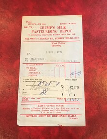
Document - Account and receipt, Receipt signed (?) ES - possibly Eric Scanlan, Crump's Milk Pasteurising Depot account with attached receipt, 2 October 1958 /6 October 1958
Crumps Dairy (Milk Pasteurising Depot) was located at 6 Benson Street, Surrey Hills on the corner of Weybridge Street until c1973. It was demolished after it had been badly vandalised. The business closed after cartons replaced glassperishables including milk, bread, meat and fruit and vegetables bottles for sale of milk. It was one of many small local facilities for processing and delivering milk that existed from the early 1920s. Eric William Walker Crump (1903-1981) headed the family business. Also involved were Kevin Eric Crump, Eric William Scanlan. NB/ Also held in this collection is a copy of a project by Chatham Primary School student, Susanne Pascoe, dated 1956 which includes photos of the dairy's operations. An oral history by Dave Croft, a driver for the dairy, who lived close by, is also relevant. The account also mentions 'Towt'. Canterbury Oliver Towt (1890-1962) was another dairyman whose premises was on the corner of Chatham and Mont Albert Roads.This is material evidence of business practice c1920s-1960s when accounts for goods received, especially perishables, were often hand-delivered on a weekly basis, with monies owed collected at the door. A paper account printed red on cream (discoloured) paper with the details of the date, account holder and address typed in and the amount owed hand-written in blue ink. The attached receipt has been stuck onto the account and filled out in grey pencil and blue ink. The amounts are in pounds, shillings and pence.Typed: 2/1; 2 OCT. 1958 M/- MATTHEWS, 42 GUILDFROD RD. SURREY HILLS, E.10dairies, crumps dairy, crumps milk pasteurising depot, kevin eric crump, eric william scanlan, eric william walker crump, towt's dairy, canterbury oliver towt, accounts, receipts, guildford road, geoff matthews, ruth matthews, benson street, towts rosehill dairy -
 Surrey Hills Historical Society Collection
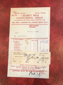
Document - Account and receipt, Receipt signed (?) ES - possibly Eric Scanlan, Crump's Milk Pasteurising Depot account with attached receipt, 16 October 1958 /20 October 1958
Crumps Dairy (Milk Pasteurising Depot) was located at 6 Benson Street, Surrey Hills on the corner of Weybridge Street until c1973. It was demolished after it had been badly vandalised. The business closed after cartons replaced glassperishables including milk, bread, meat and fruit and vegetables bottles for sale of milk. It was one of many small local facilities for processing and delivering milk that existed from the early 1920s. Eric William Walker Crump (1903-1981) headed the family business. Also involved were Kevin Eric Crump, Eric William Scanlan. NB/ Also held in this collection is a copy of a project by Chatham Primary School student, Susanne Pascoe, dated 1956 which includes photos of the dairy's operations. An oral history by Dave Croft, a driver for the dairy, who lived close by, is also relevant. The account also mentions 'Towt'. Canterbury Oliver Towt (1890-1962) was another dairyman whose premises was on the corner of Chatham and Mont Albert Roads.This is material evidence of business practice c1920s-1960s when accounts for goods received, especially perishables, were often hand-delivered on a weekly basis, with monies owed collected at the door. A paper account printed red on cream (discoloured) paper with the details of the date, account holder and address typed in and the amount owed hand-written in blue ink. The attached receipt has been stuck onto the account and filled out in grey pencil and blue ink. The amounts are in pounds, shillings and pence.Typed: 2/1; 16 OCT. 1958 M/- MATTHEWS, 42 GUILDFROD RD. SURREY HILLS, E.10dairies, crumps dairy, crumps milk pasteurising depot, kevin eric crump, eric william scanlan, eric william walker crump, towt's dairy, canterbury oliver towt, accounts, receipts, guildford road, geoff matthews, ruth matthews, benson street, towts rosehill dairy -
 Surrey Hills Historical Society Collection
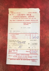
Document - Account and receipt, Receipt signed (?) ES - possibly Eric Scanlan, Crump's Milk Pasteurising Depot account with attached receipt, 18 September 1958 /22 September 1958
Crumps Dairy (Milk Pasteurising Depot) was located at 6 Benson Street, Surrey Hills on the corner of Weybridge Street until c1973. It was demolished after it had been badly vandalised. The business closed after cartons replaced glassperishables including milk, bread, meat and fruit and vegetables bottles for sale of milk. It was one of many small local facilities for processing and delivering milk that existed from the early 1920s. Eric William Walker Crump (1903-1981) headed the family business. Also involved were Kevin Eric Crump, Eric William Scanlan. NB/ Also held in this collection is a copy of a project by Chatham Primary School student, Susanne Pascoe, dated 1956 which includes photos of the dairy's operations. An oral history by Dave Croft, a driver for the dairy, who lived close by, is also relevant. The account also mentions 'Towt'. Canterbury Oliver Towt (1890-1962) was another dairyman whose premises was on the corner of Chatham and Mont Albert Roads.This is material evidence of business practice c1920s-1960s when accounts for goods received, especially perishables, were often hand-delivered on a weekly basis, with monies owed collected at the door. A paper account printed red on cream (discoloured) paper with the details of the date, account holder and address typed in and the amount owed hand-written in blue ink. The attached receipt has been stuck onto the account and filled out in grey pencil and blue ink. The amounts are in pounds, shillings and pence.Typed: 2/1; 18 SEPT. 1958 M/- MATTHEWS, 42 GUILDFROD RD. SURREY HILLS, E.10dairies, crumps dairy, crumps milk pasteurising depot, kevin eric crump, eric william scanlan, eric william walker crump, towt's dairy, canterbury oliver towt, accounts, receipts, guildford road, geoff matthews, ruth matthews, benson street, towts rosehill dairy -
![Map, Liquidator's sale, 1896. [Woolpack Estate, Bacchus Marsh]](/media/collectors/5e461d8021ea67224c82f2a1/items/6779ee97032b72846b5995f2/item-media/6779ef33032b72846b599b30/item-fit-380x285.jpg) Bacchus Marsh & District Historical Society
Bacchus Marsh & District Historical SocietyMap, Liquidator's sale, 1896. [Woolpack Estate, Bacchus Marsh]
The Woolpack Estate was an area of land owned by various landowners in the Bacchus Marsh area since the early Colonial period of the 1840s. The area was located on the eastern side of the Bacchus Marsh township about 7 kilometers from the town. The Lerderderg River ran through part of the land and so did the Melbourne to Ballarat Road. The historic Woolpack Inn associated with James Crook was also located on this land. By 1896 150 acres of this land was under the control of liquidators for the Federal Bank of Australasia who instructed that the land be sub-divided and sold in lots by public auction. A successful sale was held on 24 June 1896. Most of the blocks of land were sold for higher than expected prices and most of the buyers were people from the town and district of Bacchus Marsh. The map includes various details about the land which is described on the map as an "important sale of rich alluvial irrigable flat land in the Bacchus Marsh Valley, and other properties". The auction was conducted by the local agents W. Anderson and Bence in conjunction with Pearce Brothers also of Bacchus Marsh.A single page paper map showing a plan of 150 acres of land from the Woolpack Estate to be sold in various lots in June 1896. Also shown on the map are lots for sale at Robinson's Farm on Coimadai Creek and allotments near Bacchus Marsh railway station, including lots on Government Road (East Maddingley Road), View Street and Government Road (Parwan Road). No scale provided. The map is pasted into a bound volume containing 76 maps or plans in total. High resolution digital image stored on BMDHS computer network. land sales bacchus marsh, bacchus marsh victoria maps, woolpack estate bacchus marsh victoria -
 Kew Historical Society Inc
Photograph - Clarence Kindergarten and Sub-Primary, 180 Cotham Road, 1930-1935
180 Cotham Road, formerly 178 and later 210 Cotham Road, described as a brick residence of six rooms, was constructed in c.1890, for Alexander Hall, a dentist. From 1903, Miss Florrie Wymond operated a girls school at the property, and a timber schoolroom building was constructed at the rear of the property. During the 1930s, the school was known as the Clarence Primary School, and operated by Misses F L and M Wymond. While the listing of the property as a primary school had ceased by 1947, the Wymond family owned the property until the mid 1960s. (Source: Lovell Chen 2007, Review of B-graded buildings in Kew, Camberwell and Hawthorn).One of three photographs taken between 1930 and 1935 of students of 'Clarence' Kindergarten and Sub-Primary, located at 180 Cotham Road. The photos were accompanied by detailed notes identifying the names of students (where remembered).schools -- kew (vic.), clarence school, clarence house, 180 cotham road -- kew (vic.) -
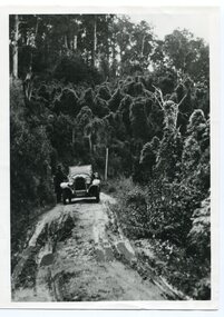 Orbost & District Historical Society
black and white photograph, 1924
History unknown. Oswald Stuart Green taught at the Bete Bolong State School in the 1920s /30s. He wrote many books about East Gippsland including several on thee Orbost / Marlo district.Oswald Green has an association with the Orbost area.A black / white photograph of a dirt road in the bush with a motor vehicle on the road and a man standing beside it.on back - " O.S. Green 31 Malcolm St Blackburn Princes Highway east of Coolwater Creek."princes-highway-coolwater-creek green-oswald-stuart -
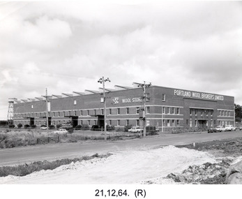 Glenelg Shire Council Cultural Collection
Photograph - Photograph - Portland Wool Brokers Limited, Wool Store, 1964
Port of Portland Authority archivesFront: (no inscriptions) Back: 12-8 Items date & 25½ [each ?] (blue pen, centre) 4572 (lower centre, pencil) Page 11 (lower right, blue pen) Film No. I.98/ Neg. No. 3/ Date 21-12-64/ (Portland Studios, 11 Julia St, Portland. Tel. 858 (blue stamp & pencil) (centre)port of portland archives -
 Orbost & District Historical Society
black and white photographs, late 19th century - early 20th century
3254.1 shows aTculvert over the gully at the foot of Burn’s Hill cutting at Newmerella and has been taken looking up tpward Burn's Cutting at Newmerella .Photograph 3254.2 has been taken from below the cutting. More information in Newsletter, November 2010.These photographs are pictorial records of Burn's Cutting and the old coach road in a time before the establishment of the Orbost to Bairnsdale railway line.Two black / white photographs of a gravel road on the side of a cutting. Both have a coach on the road. burn-road-newmerella cutting-newmerella coach-road-newmerella -
 Whitehorse Historical Society Inc.
Document, Business Card, n.d
Business card for Thomas Scott, tinner and galvanizer of Victoria Road, Mitcham (now Rooks Road).scott, thomas, rooks road, mitcham -
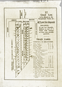 Whitehorse Historical Society Inc.
Document, 37 Good Lots
Brochure advertising 37 lots bounded by Mount Pleasant RoadBrochure advertising 37 lots bounded by Mount Pleasant Road, Menin Road and Shady GroveBrochure advertising 37 lots bounded by Mount Pleasant Roaddooland & goodchild, mount pleasant road, nunawading, menin road, shady grove -
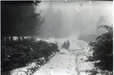 Mt Dandenong & District Historical Society Inc.
Photograph, Motorcycle and Sidecar in Snow, Olinda, c1921
A motorcycle with sidecar travelling down a snow covered road at Olinda. possibly Chalet Road. c1921.olinda, motorcycle, sidecar, snow, chalet road, iris woolrich -
Canterbury History Group
Photograph - Canterbury Road, c1970
Black & white photograph of Canterbury Road shops looking to the east from Balwyn Road. c1970.canterbury, canterbury road, carnell & sons, railway bridges -
Canterbury History Group
Photograph - View across Canterbury Road, corner of Rochester Road, towards Maling Road, Canterbury
Black and white photograph, corner of Canterbury and Rochester Roads looking towards Maling Road, Canterburycanterbury, canterbury road, maling road, rochester road, e.s.& a. bank, pharmacies, horses, horse drawn vehicles, kerbing and guttering -
 Ringwood and District Historical Society
Map - Plan of Subdivision, Part of Crown Section 24, Parish of Warrandyte, County of Evelyn - undated, circa 1951
Survey map of residential allotments in Milne Road, east of Berringa Road, Park Orchards, Victoria. -
Canterbury History Group
Photograph - Corner of shop No. 111 Maling Road at the corner of Maling Road and Theatre Place, Jan Pigot, 27/03/1993 12:00:00 AM
Coloured photograph of the corner of shop No. 111 Maling Road at the corner of Maling Road and Theatre Placecanterbury, maling road, shops, streetscapes -
Canterbury History Group
Photograph - Group of Maling Road traders in period costume posing for a photograph in Maling Road, Jan Pigot, 27/03/1993 12:00:00 AM
Coloured photograph of a group of Maling Road traders in period costume posing for a photograph in Maling Roadcanterbury, maling road, shops, fashion -
Canterbury History Group
Photograph - Group of Maling Road traders in period costume, Jan Pigot, 27/03/1993 12:00:00 AM
Coloured photograph of a group of Maling Road Traders in period costume posing for a photograph in maling Roadcanterbury, maling road, shop, fashion -
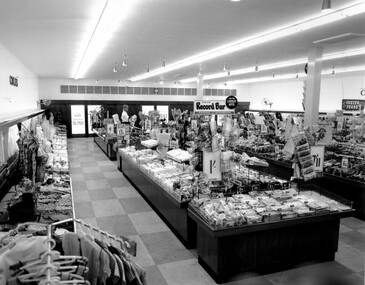 City of Kingston
Photograph - Black and white, c. 1956
This photograph depicts the interior of the Coles Variety Store within Bentleigh's Centre Road shopping precinct in 1956. Signage represents the pre decimal currency era. The Record Bar advertises the availability of standard and microgroove vinyl records.In this era, the Centre Road Bentleigh shopping strip provided consumers with access to many of the major retail outlets and provided for a wide range of shopping needs. By the 1960s, Chadstone Shopping Centres (opened 1960) and Southland (opened 1968) had been established which created changes to the way in which people shopped.Black and white photograph of interior of Coles Store in Centre Road, Bentleigh displaying prominent signage predating decimal currency. Other signage includes the Coles Record Bar indicating the sale of standard and microgroove vinyl records.Handwritten in blue ink: Coles Bentleigh Sep 1956 B Black printed text on white round adhesive sticker: 202 Handwritten in red ink: 80%shopping strip, strip shopping, bentleigh, city of moorabbin, coles stores -
Whitehorse Historical Society Inc.
Article, Biography notes City Designers Skills, 1991
Anne Latrielle's new Biography of noted Melbourne Landscape Gardener, the late Ellis Stones,Anne Latrielle's new Biography of noted Melbourne Landscape Gardener, the late Ellis Stones, entitled 'The Natural Garden', contains some fascinating snippets about Nunawading. He had 'innovative' ideas on planting median strips along Springvale and Canterbury Roads.Anne Latrielle's new Biography of noted Melbourne Landscape Gardener, the late Ellis Stones,landscapes, stones, ellis, blackburn and district tree preservation society, latreille anne - the natural garden -
 Eltham District Historical Society Inc
Newsletter, Newsletter, No. 120 May 1998
Contents: • Next meeting, Speaker Panel; Personal Projects by Members and Friends • Nillumbik Gayip • Lower Plenty Excursion • Annual General Meeting • Subscriptions • 728 Main Road • Coming Events, Happenings and Other News The Shire of Eltham Historical Society was formed in October 1967. The first newsletter of the Society was issued May 1978 and has been published continuously ever since on a bi-monthly basis. With the cessation of the Shire of Eltham in late 1994, the Society's name was revised to Eltham District Historical Society and this name first appeared with issue No. 103, July 1995. The collection of the Society's newsletters provides a valuable resource on the history of the Society's activities, office bearers and committee members, guest speakers and subjects of historical interest pertinent to the former Shire of Eltham and the Eltham District.A4 photocopied newsletter distributed to membersnewsletter, eltham district historical society, shire of eltham historical society -
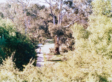 Eltham District Historical Society Inc
Photograph, Eltham Town Park (previous tip site)
One of a set of display images thought to be produced by the Shire of Eltham c.1979-1987. Eltham Town park is a reclaimed tip site and was later named the Alistair Knox Park. It is located in Main Road, ElthamIllustrative of services provided by former Shire of ElthamColour photograph 20 x 29 cm mounted on green-painted cardboard 25.5 x 30.5 cmTitle printed on label adhered to board below photograph (replaced June 2017)eltham town park, alistair knox park -
Glen Eira Historical Society
Book - Local Government Act First Report of the Assistant Commissioner of Roads and Bridges
This file contains 1 item: 1/The Local Government Act, First Report of the Assistant Commissioner of Roads and Bridges, printed by order of the Victorian Legislative Assembly on 08/03/1865. The document is the first annual report of John Steavenson, Assistant Commissioner of Roads and Bridges under s330 of the Local Government Act no. 176 (1863), and relates to transactions which took place from 02/09/1863 to 31/12/1864. The report outlines operations carried out by the Department of Roads and Bridges in this period. In the Glen Eira area this includes: separating electoral subdivisions of single districts (Moorabbin), adding detached portions of territory to road districts and shires (Caulfield), appointing of and altering in polling places, appointing of polling places for ridings of shires and subdivisions of road districts (Moorabbin), preparing and transmitting of forms of books also of pro forma accounts for guidance of local bodies in keeping their accounts, appointment of main roads, construction of a main road, ‘Dandenong’, in the Caulfield and Gardiner districts, proclaiming of Common Toll Roads, names of and security given by Managers of Common Toll Roads. The report also gives some information about the Shire of Caulfield, which contained 24 road districts and 340 rate payers in 8¼ square miles, and the Shire of Moorabbin, which contained 62 road districts and 713 rate payers in 30 square miles.local government act, assistant commissioner of roads and bridges, legislative council, caulfield historical soceity, steavenson john, sullivan j. f. the honourable, caulfield, moorabbin, road districts, point nepean road, nepean highway, dandenong road, princes highway, brown edwin, osher joseph, cosgrove john, ferres john, roads and bridges offices, caulfield roads district, moorabbin roads district, road construction and maintenance, roads and streets, acts of parliament -
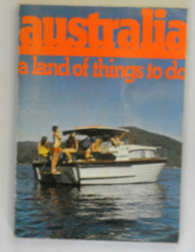 Orbost & District Historical Society
book, John Sands Pty Ltd, Australia - a land of things to do, 1974
This item is a useful reference tool as a contemporary tourism guide for the mid 1970's.A 234 pp book titled, "australia a land of things to do" in bright red print. Below is a coloured photograph of a group of people in a small motor boat. It is a tour guide for travellers in Australia.on back - "Bairnsdale Tourist Bureau 211-213 Main Street Bairnsdale Vic 3875"tourism travel-guide book-australia-a-land-of-things-to-do -
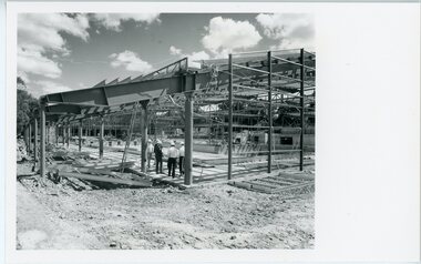 Ringwood and District Historical Society
Photograph, Ringwood Council- Aquatic Centre
Black and white photograph"Written on back of photograph" Ringwood Aquatic Centre Roof structure over main pool -
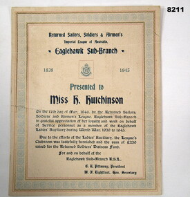 Bendigo Military Museum
Certificate - APPRECIATION EAGLEHAWK RSL AUXILIARY, C. May 1946
This certificate was awarded by the Eaglehawk RSL Sub Branch to Miss H. Hutchinson (Hanna) on 17.5.1946 in Appreciation and loyalty to Service personnel as a Member of the Eaglehawk Ladies Auxiliary during the War years. The Auxiliaries efforts abled the furnishing of the Club rooms and raise 230.00 Pounds for the Returned Soldiers Distress Fund. Hanna was awarded the BEM (British Empire Medal in 1978 Refer Cat No 8212.2 for her Sister Florrie and Photo Cat No 8200P. Certificate on cardboard cream coloured with ornate edging in red, blue and brown, all printed text in black & blue, covers the years 1939 - 45, dated at the bottom.Main points, "Eagle Hawk RSL Sub Branch", "Presented to Miss H Hutchinson"brsl, smirsl, auxiliary, certificate, ehrsl -
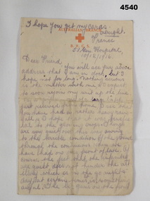 Bendigo Military Museum
Letter - LETTER 1916, C.1916
The letter gives a graphic description of the front line and is signed of with just “Will”, a number with 4 digits is under this, possibly a Regt No but it does not match up with anyone re the date on the letter. Letter in the collection relating to A.G Ferris No 2156 AIF, refer Cat No 4183.3P for his service details.Letter, “Australian Branch of the Red Cross”, letter head in red, hand written in black pencil, dated, double sided.main point. “France, 51st Gen Hospital 10/12/1916”, “Dear Friend”letters, red cross -
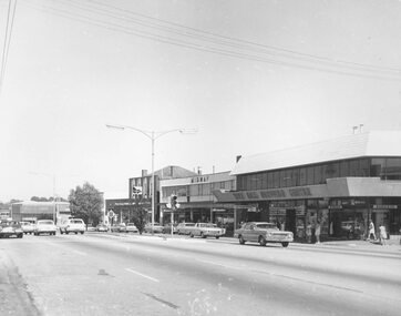 Ringwood and District Historical Society
Photograph, Maroondah Highway Central, Ringwood. Melbourne Street to Ringwood Street - 1974
Black and white photographWritten on rear of backing sheet: "Main St., Melbourne St. to Ringwood St., 1974."