Showing 1174 items
matching 'church and people'
-
 Friends of Ballarat Botanical Gardens History Group
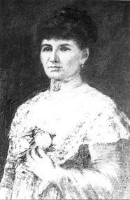
Work on paper - Tilly Thompson nee Matilda Louise Clennell 1871-1959. by Roy Mosman, Research Notes and Introduction to a Talk, 24/2/2000
Matilda Thompson was known for her business acumen and philanthropy in Ballarat. Roy Mosman made these notes in preparation for a talk he gave to the Friends of Ballarat Botanical Gardens.These notes by Roy Mosman include details of Tilly Thompson's life not found elsewhere. They are testament to Mrs Thompson's active participation in Ballarat life. So many people knew her or knew of her, because of her many contributions to the community.9 pages of notes in longhand headed "Tilly Thompson, Introduction to Talk" and dated 24/2/2000.Rough notes in black biro with amendments and additions throughout.john garner, doctor john garner, matilda louise thompson., roy mosman, tilly thompson garden, ballarat botanical gardens, friends of ballarat botanical gardens, e.lucas &co pty.ltd, arch of victory, avenue of honour, methodist church, ballarat courier, john garner collection, gardens, ballarat -
Canterbury History Group
Document - Canterbury c1900, Tilley, Myrtle
Memories of the shops, and lifestyle of people in Canterbury c.1900canterbury, pharmacies, weymouths ironmongery, shops, canterbury gardens, redmans bakery, schools, canterbury baptist church, creeks, doery family, rochester road, livestock, lifestyle, tilley> myrtle -
 Royal District Nursing Service (now known as Bolton Clarke)
Photograph - Photograph, Portrait black and white, c.1900
This is a photograph taken from the painting by McCubbin of Lady Janet Clarke, a prominent Melbourne philanthropist who worked for social welfare issues and was a driving force in the early days of the Melbourne District Nursing Society. At the end of 1885 for her work with MDNS she was given a Testimonial Dinner where she was presented with a letter signed by 429 people expressing their thanks for her visits, kindness, sympathy and charity shown toward the sick poor. In 1887, at her home, she held the first function to raise money for the Society. Lady Janet Clarke was a generous and hospitable prominent socialite of Melbourne; a kind and sympathetic philanthropist who worked tirelessly for social welfare issues. The Melbourne District Nursing Society (MDNS) was founded on the 17th of February 1885 and on the 9th of April a Special General Meeting was held to elect the committee for the following twelve months. Lady Clarke was elected a Vice-president; a position she held until being appointed President, when Mrs. Simon resigned on the 7th of June 1887, a role Lady Clarke held until she became ill in 1908; except during her trips overseas, when the role was held by another until her return. Her management and organizational skills enabled MDNS to flourish in its earliest days. She was actively involved taking her turn on the Superintendent sub-committee where she accompanied a Trained nurse when she visited patients; checking that high quality nursing care was maintained, as well as observing the patient's social condition; even giving a personal donation to a special case in need. The patients of the Society were so grateful for her sympathy, kindness and love that when she and her husband, Sir William Clarke, were going overseas at the end of 1885, a Testimonial was given for her at Scots Church District-hall where 200 attended to show their appreciation of her work carried out with MDNS. She was presented with a Bible from them, and their letter signed by 429 working persons expressing their thanks. In a time of great financial need of the Society, Lady Clarke offered the ballroom at her home, 'Cliveden', for a monster Cake, Flower, and Dairy produce Fair which raised a substantial amount saving the Society from closure. She promoted the Society and led it in further fund-raising events, such as the annual Ball, and Fairs where she often manned cake stalls. Near Christmas each year she made a special appeal to the public for 'comfort and good cheer' which could be given to poor families visited by the Society. During the depression of 1890 she had thick soup prepared in the Cliveden kitchens and this was distributed, with bread, from her home, and from a school room, to hundreds of the poor. In 1892 Lady Clarke agreed to represent the Society during her visit to England. During her years of leadership MDNS expanded; Nurses uniforms were introduced; lectures - for example, on hygiene and on the prevention of sickness and the treatment of children, were given by doctors for the patients; further Trained nursing staff were employed; Midwifery was introduced to the poor, the Society extended beyond the city centre and bicycles were introduced for transport; a system for regular annual subscriptions was introduced and sufficient funds were raised for the Society to rent its own premises, with Lady Clarke paying for a subscription to Mullen's bookstore each year for the use of the Nurses in the Nurses Home. As well as her work for MDNS she held roles in many other organizations . She donated a substantial amount of money to build a Hostel for Women University Students attending Trinity College, later named the Janet Clarke Hall. Lady Janet Marion Clarke died at Cliveden, aged 57 years, on the 28th of April 1909; a lady held in high esteem and affection by all she knew.This is a black and white photograph of a painting of Lady Janet Clarke. She is looking forward and has a serious visage; she is wearing her long dark hair drawn up and back and in her left ear a small dropped ear ring can be seen. She is wearing a light coloured, long sleeved, floral frock with a material short cape section seen over the top of her left sleeve. Her left arm is crooked with her hand resting just under a flower brooch fastened in the centre of her frock. She has a choker around her neck with a brooch in the centre..Janet Lady Clarke, president 1889-1908.From the painting by McCubbin.melbourne district nursing society, mdns, rdns, royal district nursing service, lady janet clarke -
 Melton City Libraries
Map, Streets of Melton, 1963
MELTON’S STREETS Heritage Week 2014 What’s in a Name? Alphabetical List Aboriginal place names, Early Family Names and landowners, Agricultural, Shop and Commercial premises, Places and Events Melton & District Historical Society Street Naming Project 1972 – c 1998 Suburb Name – KURUNJANG - Kirkton, 1972, Brookfield, West, 1988 Melton and Town Centre - A joint collaboration with the Shire of Melton and Subdivision Developers ARNOLD Court – Family house - Arnolds Creek ALKEMADE Drive Family – Lime kilns Coimadia ALEXANDRA Street 1902 – Corination of King Edward VII and Queen Alexandra AVIATOR Place Event, location of plane crash – Jimmy Melrose 1936 Adina ?Annibee - Anniba? Agricultural Avon court .. .. BAKERY Square - Location of Jongebloed shop, bakehouse and stables BALUK Place Aboriginal BARLEYCORN Place Agricultural BILLING Place Name of Jimmy Melrose Uncle Noel Pemberton Billing BLACKWOOD Drive - Alexander Blackwood 1860c Registrar BARRIES Road C. E. Barrie “Darlingsford” farmer 1911, chaff mill owner BROOKLYN Road Staughton family residence. 1875 – Dismantled c 193? CAHILL Drive Family - Glenville Dairy CAMERON Court Family Canopus Place ? CANALLAN Drive Early Surveyor CAMPBELL Court Aviation – Melrose passenger 6th July 1936 CARBERRY Drive Michael, early landowner family CAREW Court Edward and Michael. Royal Hotel. Vera (Carew) Forran Singer - Opera CASEY Court Family CASHIN Court Family CHEVIOT Court Agriculture, breed of sheep CHESNEY Road was re named ( Minns Road being duplicated c 1973) CHRISTINA Crescent Christina McPherson, daughter of James and Mary Mary McPherson. Died 1955 aged 85 years COLLYER Close a deleted street (parallel to Yuille) re-used CORRIEDALE Road Breed of sheep CORR Court Teacher at first school, landowner CROXTON Court Name of the Hornbuckle and Knox family home DALEY Court - William Daley and family 1865 Bootmaker High Street DARLINGSFORD Boulevard - Name of early homestead Thomas B Darling 1853 DJERRIWARRH Court - Parish County of Bourke - very early map. DODEMAIDE Place Early land owners - Melton Football Team had 6 brothers playing c 1924 DONALD Court McPherson family 6 generations in Melton in 1936 DOUGAL Court DUNCAN Court .. .. DUNVEGAN Circuit Home of the McPherson family, castle Isle of Skye Name of bluestone house Smith Street (now at Willows) EMIL Court Jongebloed family EXELL Avenue Farming family Melton Sth- Closer Settlement 1907 EXFORD Road Exe former name of the Werribee river FARMER Court Name of early postmistress FERRIS Road John Ferris Farmer HANNAH Close First name of Hannah Watts – midwife HAYBALE Place Agricultural HELDER Court Early surveyor J Helder Wedge map HEWSON Street Winston Hewson Shire Engineer – check title c 1960 HENRY Street Township map c 1860 HESTON Street Heston Phoenix – C.J. Melrose plane HILDEGARDE Court Jimmy Melrose’s mothers name HOMESTEAD Close HORNBUCKLE Cres Farmers. Three members of family - Shire Presidents HURLEY Street Farmers IAIN Court Descendent of James and Mary McPherson JAMES MELROSE Drive Name appears on 2013 Melton information map JANG Place KURUN – jang KIRKTON Drive Name of the McPherson family home Toolern Vale Road KIRWIN Street Michael early landowners (deleted for freeway construction) KILPATRICKS Road Deleted when Barries Road was extended across Station Rd KOROROIT Court Early map, Parish of Kororoit. Creek name KNOX Circuit Family – Hornbuckle “Croxton Park” KURRUNJANG Drive Aboriginal name for people of the red earth – Suburb name Lara Place ? LLOYD Court Garage owners High Street. Laura lived to 100 years D 1955 LUBY Court John Luby – Crown Grant Land Title LITTLE Court MANNING Avenue Richard, hotel owner 1891 MARGARET Drive McPherson family McDONALD Street Melton South family name McKENZIE Street Township c1860 MORROW Street Early name MOWBRAY Crescent Name of English Melton, popularly believed origin of Melton MYERS Court Early setters c 1866 Crown Grant Land Title NIMMO Street Early name NIXON Street Name submitted by Mary nee Nixon Collins c1985 OLDERSHAW Road Early builder PALMERSTON Street Early township map c 1860 PEART Court Early name PENNYROYAL Avenue Plant growing by the creek. Early name used for the Toolern Toolam Creek PINKERTON Street Family name and early street map PINNACLE Crescent Agricultural - type of wheat PHOENIX Circuit C.J. Melrose Phoenix Heston Plane 2013 map PRATT Family PRIOR Court PYKE Place Brothers – early settlement 1838 RADFORD Court Land owners and business operators. Former Royal Hotel Grocer High Street demolished 1970 RAGLAN Court Hotel 19th century Lord Raglan RALEIGHS Road Oliver Reierson family (Norweigen) Shopkeeper – Dressmakers RIDDELL Drive (misspelt Riddle) Resident and land owner RODERICK Road McPherson family – a re occurring name ROLLAND Court Jones family ROSS Court Daniel. Landowner. Agnes Ross music teacher RUSSELL Court Robert. Early land surveyor of Melton 1853 RYAN Court Family early landowner. Member of the 1862 Road Board SHEBLER Place Augustus early Melton resident – Golden Fleece Hotel SHEEPFOLD Court Farming SHERWIN Court Sherwin Street earliest Township map– became Golf course SMITH Street Early township map. STRATHULLOH Circuit Strathtulloh Homestead. STAUGHTON Street Family – LARGE land owners Strachan ? SWANEY Court Marie Swaney earlier resident of Strathtulloh. SUTHERLAND Family name TOOLERN Street TOOLAM – TOOLERN Creek TULLIDGE St Road marked on 1861 map UNITT Street Early Township c 1860 WALLACE Square Cr Jack Wallace 5 terms as President 46 years unopposed WATTS Court Hannah Watts – midwife, cottage hospital WALSINGHAM Name of house of Minns family. From Walsingham Norfolk England WESTLEY Place Name of Jimmy Melrose Percival Gull Plane WESTLAKE Drive Early resident WHICKHAM Street Family Name Melton South WILSON Road Albert, Melton South YUILLE Street William Cross, early landowner, Rockbank run Zoomed in section of Melton Streets including Church and High Streetlandscapes of significance -
Tarnagulla History Archive
Photograph - Photograph: Junior Rechabites, Tarnagulla, c.1895
Williams Family Collection. Monochrome photograph depicting a group of children all wearing matching ceremonial regalia, assembled in front of a brick wall. These are probably Junior Rechabites posed outside the Wesleyan Church, Tarnagulla. Original photograph mounted on card. Handwritten on reverse: "L. Williams".tarnagulla, people, children, rechabites -
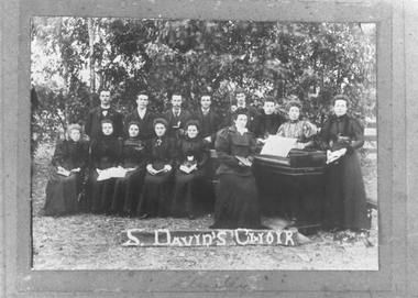 Tarnagulla History Archive
Photograph: St. David's Choir, circa 1900
Donald Clark Collection. A photograph depicting a group of people outdoors, some seated with songbooks, one seated at a piano, and one standing. Caption incorporated into image reads 'St. David's Choir'. Copy photograph. Writing on reverse indicates the choir is from the Church of England at Llanelly, Victoria.music, choirs, churches -
Canterbury History Group
Photograph - Highfield Road Baptist Football Club, A. C. Aberline, 1938
Black and white photograph of the Highfield Road Baptist Football Club premership team of 1938.Lists all people in the photograph.canterbury, highfield road, baptist church, football clubs, belmore> r .(rev.), wain> f., burrows> d., woods> w., macclelland> r., coutts> r., yeomans> e., lenne> i., hair> m.r., lenne> a., wilson> g., potter> r., murray> r, blackburn> g, findlay> k., dick> a., woolf> l., enderby> w., findlay> j., lenne> d., wain> e., hancock> a., tipping> g, blameirs> a., carter> g., cook> mr. -
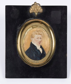 Bacchus Marsh & District Historical Society
Painting - Portrait, William Henry Bacchus, 1782-1849, Circa 1808-1818
Artist is not known. Comments recorded at the time of purchase are that it is possibly by 'Plimer'. Andrew Plimer, 1763-1837 and his brother Nathaniel Plimer, 1757-1828, were notable British miniaturist portrait painters.William Henry Bacchus was one of the first British colonists to arrive in the Waddawurrung and Wurundjeri first nations peoples country 55 kilometers west of Melbourne in 1838. He established a large sheep property and built a notable large Georgian style home which still stands in the town of Bacchus Marsh today. From shortly after his arrival the area became known to the colonists as Bacchus's Marsh, and was later officiaslly named 'Bacchus Marsh' in his memory.Small framed painting of William Henry Bacchus. On the reverse is a label which reads: Captain William Henry Bacchus who arrived in the district of Bacchus Marsh early in 1838, was born in Suffolk, England, 1782, and died at Bacchus Marsh on 26 February 1849. His remains were interred in the graveyard of Holy Trinity Church which during his lifetime he had richly endowed with a gift of land. He was a Captain of the 2nd Royal Surrey Militia and formerly Captain of the 18th Light Dragoons.bacchus family, william henry bacchus 1782-1849 -
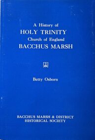 Bacchus Marsh & District Historical Society
Booklet, A History of Holy Trinity Church of England Bacchus Marsh
According to this publication a place of Anglican worship in Bacchus Marsh is said to have existed since at least 1847 when an early Bacchus Marsh colonist George Hobler recorded attending services in his journal. This short book is a record of the Anglican or (Church of England) in Bacchus Marsh from that time up to 1977 when the centenary of the Holy Trinity Church building was celebrated in Bacchus Marsh. A earlier smaller edition was published in 1971 and this work expands upon that edition. The 1977 edition includes photographs of some of the early significant identities in the Church's history. Also included are a number of appendixes which includes a list of the Clergy from this parish from 1849 until 1977, a list of people buried in the Church graveyard, a record of the first baptisms and marriages and detailed notes about the Church windows and Memorials. Pages 51-53 are notes on sources cited in the work. Citation: A History of Holy Trinity Church of England Bacchus Marsh by Betty Osborn. Published by Bacchus Marsh and District Historical Society, Bacchus Marsh, Vic., 1977.A booklet of 53 numbered pages. Stapled binding. Contains black and white photographs and illustrations. BMDHS Loc: AR/SU5/Pamphlets Box 4According to this publication a place of Anglican worship in Bacchus Marsh is said to have existed since at least 1847 when an early Bacchus Marsh colonist George Hobler recorded attending services in his journal. This short book is a record of the Anglican or (Church of England) in Bacchus Marsh from that time up to 1977 when the centenary of the Holy Trinity Church building was celebrated in Bacchus Marsh. A earlier smaller edition was published in 1971 and this work expands upon that edition. The 1977 edition includes photographs of some of the early significant identities in the Church's history. Also included are a number of appendixes which includes a list of the Clergy from this parish from 1849 until 1977, a list of people buried in the Church graveyard, a record of the first baptisms and marriages and detailed notes about the Church windows and Memorials. Pages 51-53 are notes on sources cited in the work. Citation: A History of Holy Trinity Church of England Bacchus Marsh by Betty Osborn. Published by Bacchus Marsh and District Historical Society, Bacchus Marsh, Vic., 1977.churches bacchus marsh, anglican church bacchus marsh, holy trinity anglican church bacchus marsh, holy trinity church of england bacchus marsh, clergy bacchus marsh -
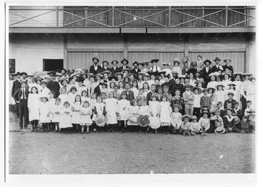 Tarnagulla History Archive
Photograph: Large group in front of Recreation Reserve Pavillion, Tarnagulla, c.1905
Murray Comrie Collection. Women's attire suggests circa turn of century. This photograph is a reasonable copy created from an older original. Copy probably made by Murray Comrie in the 1970s.Monochrome photograph of a large group of people, including many children, posed in front of the Recreation Reserve Pavillion in Tarnagulla.tarnagulla, recreation reserve, pavillion, religion, church, community events, picnics, children -
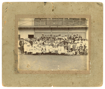 Tarnagulla History Archive
Photograph: Large group in front of Recreation Reserve Pavillion, Tarnagulla, Large group in front of Recreation Reserve Pavillion, Tarnagulla, c.1905
Murray Comrie Collection. Women's attire suggests circa turn of century. This photograph is an original print. Monochrome photograph of a large group of people, including many children, posed in front of the Recreation Reserve Pavillion in Tarnagulla.tarnagulla, recreation reserve, pavillion, religion, church, community events, picnics, children -
Tarnagulla History Archive
Box of Murray Comrie's Research Notes (Set 2), Murray Comrie's Research Notes (Set 2), circa 1960s-80s
Murray Comrie Collection. Murray Comrie, born in Tarnagulla in 1912 also became a policeman and later a Chief Superintendent, retiring in 1972 and passing away in 1983 after a long illness. Murray Comrie's son Murray Jnr., to avoid confusion became known by his middle name, Neil. Neil Comrie also joined Victoria Police and rose through the ranks to become Chief Commissioner of Victoria Police from 1993 to 2001. Blue-grey archive box containing research notes of Murray Comrie. Contains: A series of 17 notepads in which Comrie has annotated historical information from local newspapers. A very long rolled up piece of paper on which is printed the Comrie family tree A yellow envelope containing photogrpahs which are low-quality and/or duplicates of other images in the Murray Comrie Collection. A ledger in which Comrie has listed every Police Station in Victoria and its establishment date. Four vinyl non-archival document binders in which Comrie's research notes and photographs were housed when donated. Material was transferred out of these for preservation reasons. The contents of this box were compiled or used by Murray Comrie during his research for a book about Tarnagulla. tarnagulla, comrie, research, banks, lodge, gold & mining, war/military, local people, buildings, businesses, local government, post offices, policing, recreation reserve, railway, clubs & societies, band/music, hotels, churches, schools, fire brigade, laanecoorie, names -
Tarnagulla History Archive
Newspaper excerpt - Inglewood Advertiser, Inglewood Advertiser, June 20, 1963
Don Clark Collection. Two-page excerpt from the Ingelwood Advertiser newspaper of June 20th, 1963 with several articles. One relates to Mrs Winne Bellenger leaving Arnold (mentions James H. Allen / Jim Allen, Ted Younghusband and Mrs J.H. Allen and musicians C. Martyn, Fred Chamberlain and George Wilson.), another relates to Tarnagulla Hall event. Another small articles reports on Mrs Neil Bramley of Arnol hurting her leg in a fall. Inside is an obituary for lifelong Tarnagulla resident Emma Harwood, 'devout parishioner of the Tarnagulla Presbyterian Church'. tarnagulla, arnold, people, hall, emma harwood, winnie bellenger, jim allen, presbyterian church, music, musicians -
Tarnagulla History Archive
Research file: St. Saviour's Church Of England Tarnagulla, Baptism & Marriages 1862-1974, St. Saviour's Church Of England Tarnagulla, Baptism & Marriages 1862-1974, 1974
Donald Clark Collection. An series of transcribed historical records (dates, names etc) in a plastic sleeve folder with title 'St. Saviour's Church Of England Tarnagulla, Baptism & Marriages 1862-1974'. Must have been transcribed from an original church source (not clear which one), probably by Donald Clark.tarnagulla, church of england, st saviours, births, baptisms, marriages, people -
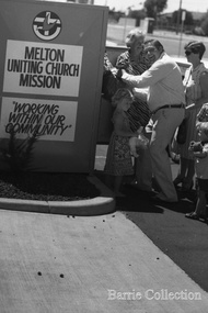 Melton City Libraries
Photograph, Melton Uniting Church Misson Collection bin, Unknown
Edna Barrie and unidentified people standing in front of a collection binchurches, local identities -
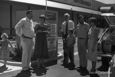 Melton City Libraries
Photograph, Melton Uniting Church Misson Collection bin, Unknown
Bon Barrie had a lifetime association with Melton Uniting Church (and its predecessors the Methodist, Methodist-Presbyterian churches) which extended from childhood when he attended Sunday school until his death in 1985. Member of the Presbyterian Board of Management for more than 25 years in which he held positions of Honorary Secretary and Treasurer, Board member of the Parish Council and Member of the Committee of Management. He was a Sunday school teacher 1933. Ernest W (Bon) Barrie with a group of people standing next to the donation binchurches, local identities -
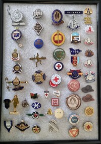 Wodonga & District Historical Society Inc
Badge - Badge Collection
This is a collection ranging in dates from 1917 to the 1980s. It reflects a range of local and national organisations supported by people in the community. These include local schools such as the Wodonga Central School and Wodonga High School and local sporting clubs including the Wodonga Football Club and the Wodonga Bowling Club. National organisations like Red Cross, the Returned Soldiers' League, Legacy and the CWA are also represented.This collection commemorates a range of local and national organisations supported by community members throughout the 20th century.A collection of 50 different badges to commemorate a range of organisations and events. Included are several ANZAC Day and Legacy badges. Also in the collection are badges for Girl Guides, several sports clubs, Red Cross, Red Triangle Day 1917, the CFA and some church groups.commemorative badges, memorabilia, service organisations -
 Wodonga & District Historical Society Inc
Booklet - Hamilton-Smith Collection Air Raid Precautions Booklet, T. Rider - Government Printer, September 1939
The Hamilton-Smith collection was donated by the children of Grace Mary Hamilton-Smith nee Ellwood (1911-2004) and John Hamilton-Smith (1909-1984) who settled in Wodonga in the 1940s. The Ellwood family had lived in north-east Victoria since the late 1800s. Grace’s mother, Rosina Ellwood nee Smale, was the first teacher at Baranduda in 1888, and a foundation member of the C.W.A. Rosina and her husband Mark retired to Wodonga in 1934. Grace and John married at St. David’s Church, Albury in 1941. John was a grazier, and actively involved in Agricultural Societies. The collection contains significant items which reflect the local history of Wodonga, including handmade needlework, books, photographs, a wedding dress, maps, and material relating to the world wars. This Air Raid Precautions booklet was one of thousands distributed to households across Australia during WW2. They provided instructions on what to do during an air raid and were based on emergency response protocols established in Britain. Other measures adopted by State Governments during this period included the installation of air raid sirens and bomb shelters, and the training of volunteers in firefighting and first aid. This item has well documented provenance and a known owner. It forms part of a significant and representative historical collection which reflects the local history of Wodonga. It contributes to our understanding of life in Australia during WW2. A small booklet containing illustrations and text instructing people what to do during an air raid. Front cover in pen: "Donated: Merrilyn/Hamilton-Smith"ww2, world war two, world war, war, 1940s, air raid, defence, bomb -
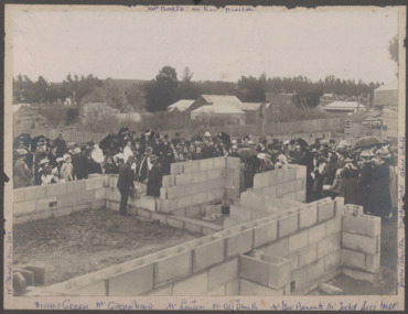 Linton and District Historical Society Inc
Photograph, Laying Foundation Stone, St. Paul's Sunday School, Linton, 1909, 1909
Black and white image of a large crowd of people watching as a foundation stone is laid in the brickwork of a building under construction. The crowd consists of men, women and children with buildings in the background. Bishop Green is next to the two men who are laying the stone. The image has been mounted on dark grey card.buildings, sunday schools, churches, mrs. bolte, bishop green, parish halls -
 City of Kingston
Photograph - Colour, Paul Tresize, 1998
The name Mordialloc was derived from the name Moody Yallock, which comes from the Bunurong language. The Bunurong Peoples are the Traditional Owners of this area. The name means “high water” or “high creek”. In 1839, colonial authorities declared the mouth of the creek, and an additional 830 odd acres as an Aboriginal Reserve, although this proclamation was never gazetted. The reserved land included part of the Carrum Carrum Swamp which was abundant with wild life and natural resources. Regular encroachments, including land sales which began in 1863, were made on the land until 1878 when the Reserve was declared closed, and the land was opened up to land sales. Market gardening and suburban house lots quickly began to develop, and Mordialloc became a renowned picnic and holiday site. Mordialloc Creek is a popular bay side destination for local and visitors, and is a site for boating, kayaking, fishing and swimming, along with many other activities.Colour photograph of Mordialloc Creek with boats moored on both sides of the street and Pompei's boat yard visible on the right hand side of the creek., Main Street and St Brigid's Catholic Church are visible in backgroundmordialloc, bunurong, traditional owners, suburbs, boats, fishing, waterways, hotel, church -
City of Kingston
Photograph - Colour, Paul Tresize, 1998
The name Mordialloc was derived from the name Moody Yallock, which comes from the Bunurong language. The Bunurong Peoples are the Traditional Owners of this area. The name means “high water” or “high creek”. In 1839, colonial authorities declared the mouth of the creek, and an additional 830 odd acres as an Aboriginal Reserve, although this proclamation was never gazetted. The reserved land included part of the Carrum Carrum Swamp which was abundant with wild life and natural resources. Regular encroachments, including land sales which began in 1863, were made on the land until 1878 when the Reserve was declared closed, and the land was opened up to land sales. Market gardening and suburban house lots quickly began to develop, and Mordialloc became a renowned picnic and holiday site. Mordialloc Creek is a popular bay side destination for local and visitors, and is a site for boating, kayaking, fishing and swimming, along with many other activities.Colour photograph of Mordialloc Creek with boats moored on both sides of the street and Pompei's boat yard visible on the right hand side of the creek., Main Street and St Brigid's Catholic Church are visible in background.mordialloc, bunurong, traditional owners, boats, fishing -
City of Kingston
Photograph - Colour, 29 January 1993
Bonbeach is a small beachside suburb located between Chelsea and Carrum. The station was opened in 1926 and was the last to be established in the group from Aspendale to Carrum. Urban growth began after World War II. State primary and high schools were opened in 1958 on land in Breeze Street that was once occupied by The Australian Glass Manufacturers. Immediately east of the school sites is the Patterson River Golf Club. The Bonbeach sports reserve has five ovals and is home to the Bonbeach football and baseball clubs. The suburb borders the Edithvale-Seaford Wetlands which is the remnant site of the Carrum Carrum swamp, once the home of the Bunurong people.Bonbeach was originally a seaside destination for holidaymakers and the housing comprised of holiday homes and gradually more permanent residents. It was not until 1926 that Bonbeach had its own railway station. From 1906 until the late 1940s sand was quarried on the east side of the railway line and used in the manufacture of glass. The Australian Glass Manufacturers sold this land in residential blocks and Bonbeach's permanent population spread from the coastal strip across to the other side of the railway line. Laminated colour aerial photograph of the suburb of Bonbeach and also the southern section of neighbouring Chelsea within the City of Kingston. The extent of this 1993 aerial image includes: Top left - Maury Road at the south end of the Chelsea shopping Centre; Top right - Scotch Parade Chelsea Bottom left - Monica Avenue in Bonbeach; Bottom right - Patterson River Golf Club. Landmarks include St Joseph's Church and Primary School, Chelsea Primary School, Bonbeach Station, Bonbeach Fotball Club sports playing fields and Bonbeach Life Saving Club. The Edithvale Wetlands is featured prominently to the right-hand side of the image. Black typed writing on white adhesive label: No. 6662 Black typed writing on white adhesive label: 26E/6662, 29/1/93, 4.25 pm Black typed writing on white adhesive label: 29-1-93 Black typed writing on white adhesive label: P000109 Circular yellow adhesive sticker bonbeach, chelsea -
City of Kingston
Photograph - Colour, Circa 1993
Edithvale is a suburb in the City of Kingston. It is located between Aspendale and Chelsea on the Port Phillip Bay and built within remnant areas of the Carrum Carrum swamp. The foreshore precinct comprises a wide sandy beach, with low sand dunes and numerous historic boat sheds. The suburb consists of older style dwellings and former holiday houses, combined with mid-century housing and newer homes. The large blocks are increasingly subdivided and the existing dwellings demolished to accommodate units and townhouses, thus changing the landscape of the area and reducing the tree canopy.The beachside suburb of Edithvale was previously part of the extensive Carrum Carrum Swamp. The area was once a source of fish and eels for the Mayone-Bulluk clan of the Bunurong people. Over time the area was drained and predominantly devoted to dairy farming and holiday houses. The farms were gradually sold and subdivided with a large number of homes built after World War II and in the 1960s. Edithvale is mainly residential with a shopping strip along Nepean Highway but little significant industry was ever established in the area apart from a plaster works and confectionary factory, both now closed.Aerial colour photograph of Edithvale as viewed from Alexandra Avenue in the north to Ella Grove Chelsea/Edithvale in the south. The area is built-up with residential housing and facilities including Edithvale Primary School, numerous churches and the Edithvale Railway station. Large sections depict the remnant Carrum Carrum swamp. Edithvale Common and the former "Duck Inn" (Melbourne Water/Friends of Edithvale Seaford Wetlands) can be seen. Edithvale Recreational reserve, the valodrome and Edithvale Public Golf Course are prominent. The image shows vacant land in the area now known as Aspendale Gardens and the newer residential section of Chelsea Heights is not developed. A bike path has been established to cover the secondary drain. The Golf Links Court residential development located off Hughes Avenue is a large vacant block.Yellow circular adhesive sticker on plastic Black ink (marker): * (asterisk) Black type on white adhesive sticker: P000108edithvale, aspendale, chelsea, carrum carrum swamp -
City of Kingston
Photograph - Colour, 6 March 1993
Edithvale is a suburb in the City of Kingston. It is located between Aspendale and Chelsea on the Port Phillip Bay and built within remnant areas of the Carrum Carrum swamp. The foreshore precinct comprises a wide sandy beach, with low sand dunes and numerous historic boat sheds. The suburb consists of older style dwellings and former holiday houses, combined with mid-century housing and newer homes. The large blocks are increasingly subdivided and the existing dwellings demolished to accommodate units and townhouses, thus changing the landscape of the area and reducing the tree canopy.The beachside suburb of Edithvale was previously part of the extensive Carrum Carrum Swamp. The area was once a source of fish and eels for the Mayone-Bulluk clan of the Bunurong people. Over time the area was drained and predominantly devoted to dairy farming and holiday houses. The farms were gradually sold and subdivided with a large number of homes built after World War II and in the 1960s. Edithvale is mainly residential with a shopping strip along Nepean Highway but little significant industry was ever established in the area apart from a plaster works and confectionary factory, both now closed.Laminated aerial colour photograph of Edithvale as viewed from Alexandra Avenue in the north to Ella Grove Chelsea/Edithvale in the south. regents Park Aspendale can be seen in the top left. The area is built-up with residential housing and facilities including Edithvale Primary School, numerous churches and the Edithvale Railway station. Large sections depict the remnant Carrum Carrum swamp. Edithvale Common and the former "Duck Inn" (Melbourne Water/Friends of Edithvale Seaford Wetlands) can be seen. Edithvale Recreational reserve, the valodrome and Edithvale Public Golf Course are prominent. The image shows vacant land in the area now known as Aspendale Gardens and the newer residential section of Chelsea Heights is not developed. A bike path has been established to cover the secondary drain. The Golf Links Court residential development located off Hughes Avenue is a large vacant block.Black type on white adhesive label: 6-3-93 Black type on white adhesive label: 25/9211, 6/3/93, 11.20 am Black type on white adhesive label: 9211 Yellow circular adhesive sticker Black pencil: 9211 6-3-93 arrow pointing Nedthvale, carrum carrum swamp, aspendale, chelsea -
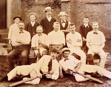 City of Kingston
Photograph - Digital image, Sepia, c. 1910
This image has been taken at the side of St Matthew's Church, Cheltenham. Sepia toned image of cricket team. There are twelve (12) people in the photograph, including two men lying down at the front, with cricket bats in their hands. While it appears to be a men's team, there are three young boys in the back row.sport, cricket, cricket club, cheltenham, cheltenham cricket club, st matthew's church -
Clunes Museum
Book, VARIOUS TITLES, 1960-1970
HYMN BOOK AND ORGAN MUSIC BOOKSOrgan Music Books .1 Living Parish Hymnal Accompaniment Book .2 Book Hymns & Music .3 The Australian Hymnal .4 Christian Brothers The Treacy Hymnal Accompaniment Book .5 Foolscap folder containing loose music sheetsHYMN BOOK AND ORGAN MUSIC BOOKShymns, sheet music, st. thomas aquinas -
 Warrnambool and District Historical Society Inc.
Journal - Ledger, Christ Church Bowls Club 1981-1995, Mid 20th century
This book contains the minutes of Christ Church Warrnambool Bowls Club from October 1981 to December 1995. The minutes refer to matters in relation to the running of the club, maintenance of the greens, social events and general procedures which are typical of a sporting club. Warrnambool had two church affiliated Bowls clubs, This particular club at Christ Church and another from St John’s Presbyterian Church. A newspaper cutting undated which is pasted to the inside front cover relates the 50th anniversary of the club.This minutes book contains a large amount of information, activities and names of people associated with the bowls clubs and as such has a strong social history and significance. Green cloth over card cover with red leather points and spine binding which has been covered with plastic tape. Dark blue and white patterned inside front and back covers. 189 pages. warrnambool, christ church bowls club, bowls club warrnambool,, christ church, bowls club, warrnambool -
 Uniting Church Archives - Synod of Victoria
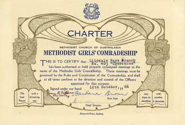
Certificate - Methodist Girls' Comradeship, Charter Lilydale Rays No 403, 1966
The Methodist Girls' Comradeship was formed in 1918 with the first Branch being in Bondi, NSW. There were three sections: Junior Rays, 8 - 11 years; Senior Rays, 11 - 15 years and Comrades, 15 years and over. The aims of the MGC was to "challenge young people with the saving power of Jesus Christ and provide avenues of christian service" and "to provide for the spiritual, social, physical and educational welfare of the members". The MGC's motto was "The Utmost for the Highest".Cream coloured charters with blue and gold print and typed information and handwritten signatures."Lilydale Rays Branch No. 403 "Cymbidium"" "12th October 66methodist girls' comradeship, methodist girls' comradeship rays' section, charters, methodist church of australasia, youth groups, lilydale rays no 403 cymbidium, barbara brown state supt., joan m williams state chief ray -
 Surrey Hills Historical Society Collection
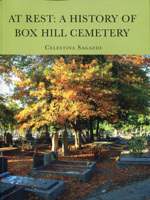
Book - At Rest: A History of Box Hill Cemetery, Celestina Sagazio
Box Hill Cemetery is the final resting place of many notable identities such as Sidney Myer, C. J. Dennis and Joy Hester, pioneers, leaders in their fields, businessmen and women, church representatives, and people from all walks of life and numerous cultures. The successes, struggles, triumphs, and tragedies of scores of individuals and families have been documented as the fledgling burial ground evolved into the serene and expansive cemetery valued by many people.A book of 25cm H, containing 250 p; index; referencesnon-fictionBox Hill Cemetery is the final resting place of many notable identities such as Sidney Myer, C. J. Dennis and Joy Hester, pioneers, leaders in their fields, businessmen and women, church representatives, and people from all walks of life and numerous cultures. The successes, struggles, triumphs, and tragedies of scores of individuals and families have been documented as the fledgling burial ground evolved into the serene and expansive cemetery valued by many people.box hill cemetery (vic.), box hill (vic.) -- history, celestina sagazio -
 Ballarat Heritage Services
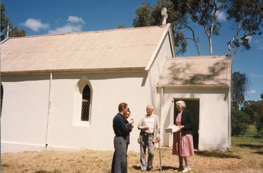
Photograph, St John's Catholic Church, Yandoit
The Yandoit Church built-in 1884 by Giacomo Satori and served the predominantly local Swiss-Italian community until 1993.Four people stand outside St John's, Yandoit. Left to right: Gerhard Emmerichs, Bern Emmerichs (Robinson) Bernie Milesi, Rene Saligari (Gervasoni)st john's yandoit, yandoit, rene saligari, bernie milesi, giacomo sartori