Showing 10971 items matching " plan"
-
 Kew Historical Society Inc
Plan - Subdivisional Sale of 11 Villa Sites, East Kew, 1939
Subdivision plans and real estate flyers/brochures reveal a number of aspects of urban development and history. The Kew Historical Society's collection of these plans, as well as advertisements extracted from magazines, cover key aspects of community development and architectural history of Kew and Kew Eat as well as surrounding suburbs. While most of the plans in the collection were gifted to the Society by the former City of Kew, a number of other plans and advertisements have been donated by individuals, of which this is an example.Single page residential subdivision plan advertising house lots for sale, in what was then designated as East Kew but is now Kew, in the following streets: Burke Road, Enfield Street. The flyer includes a smaller locality plan at right. Information on the flyer indicates that the land was previously owned by the Melbourne & Metropolitan Tramways Board.subdivision plans -- kew (vic.), enfield street -- kew (vic.), burke road -- kew (vic.) -
 Bendigo Historical Society Inc.
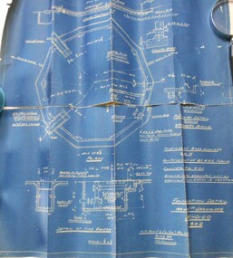
Map - BENDIGO WEEROONA GASWORKS MAP/PLAN COLLECTION: FOUNDATION DETAILS, 1942
Plan: Bendigo Weeroona Gasworks. Plan shows foundation detail 140,000 c. ft. gasholder, Bendigo, 1942. Prepared by N.J. Hurll & Co. ( Vic ) Pty. Ltd., King St., Melbourne.plan, bendigo, bendigo weeroona gas works, gas works -
Glenelg Shire Council Cultural Collection
Plan - Plans/ line drawings of the layout plan for the Trawler Wharf at Port of Portland, 11/09/1988
Port of Portland layout plans for the Trawler Wharf development.Front: '2' - black texta, top right cornerport of portland -
Canterbury History Group
Plan - Plan and letter relating to "Eurobin" property corner Cross Street and 40 Bryson Street Canterbury as at December 1919, Pam Jellie et al, 17.2.87
Detailed description in a letter with a plan of "Eurobin" 40 Bryson Street (corner Cross Street) CanterburyHandwritten letter and plan from Mr V C Le Lievre formerly lived at Eurobin in 1919, dated February 19873 x A4 pages handwritten letter and a site plan drawn on tracing papereurobin, bryson street, cross street -
 Bendigo Historical Society Inc.
Document - NORM HARRIS COLLECTION: PLAN OF 'FORTUNA 'ARMY SURVEY REGIMENT
Norm Harris Collection Plan of 'Fortuna 'Army Survey Regiment showing original buildings , original lakes and existing details together with Roman bath and a tunnel.plan, bendigo -
 Federation University Historical Collection
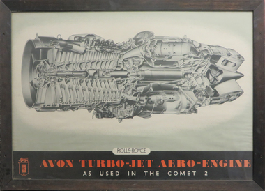
Plan - Engine, Rolls Royce Avon Turbo Jet
Framed plan of internal workings of Rolls Royce Avon Turbo Jet. plan, rolls royce, avon turbo jet, aeroplane -
Kew Historical Society Inc
Plan - Tramway Estate, Camberwell North, 1937
Subdivision plans and real estate flyers/brochures reveal a number of aspects of urban development and history. The Kew Historical Society's collection of these plans, as well as advertisements extracted from magazines, cover key aspects of community development and architectural history of Kew and Kew Eat as well as surrounding suburbs. While most of the plans in the collection were gifted to the Society by the former City of Kew, a number of other plans and advertisements have been donated by individuals, of which this is an example.Single page subdivision plan listing properties for sale in the Tramways Estate, Camberwell North. The large estate was bounded by Doncaster Road, Burke Road, Marwan Avenue, Maud Street, Severn Street, and extended over Glass's Creek at Mayland's Avenue. Within the plan, lots 3 to 342 are listed as lots. The plan includes annotations in ink indicating the prices realised by a number of lots. A key explains that lots with an 'H' represent a house, whereas the 37 shaded lots represent those being offered by this agent. subdivision plans -- camberwell (vic.), tramways estate -
Kew Historical Society Inc
Plan - Willsmere Park Estate, Kew, 1926
Subdivision plans and real estate flyers/brochures reveal a number of aspects of urban development and history. The Kew Historical Society's collection of these plans, as well as advertisements extracted from magazines, cover key aspects of community development and architectural history of Kew and Kew Eat as well as surrounding suburbs. While most of the plans in the collection were gifted to the Society by the former City of Kew, a number of other plans and advertisements have been donated by individuals, of which this is an example.Original 4-page, bifold subdivision plan of the Willsmere Park Estate, Kew. The 1926 land sale advertised '40 superb villa allotments' on the 'Yarra Heights'. Streets within the subdivision included: Willow Grove, Kilby Road, Elm Grove and Belford Road. The double page spread on pages 2 and 3 shows the detailed plan of the 40 lots, surrounded by public parkland [Willsmere Park] and the Kew Golf Links. By the time that this version of the plan was released, only the lots on Willow Grove and Kilby Road remained. willsmere park estate -- kew (vic.), subdivisions - kew (vic.), subdivisions -- kew east (vic.), willsmere park -- kew east (vic.) -
 Bendigo Historical Society Inc.
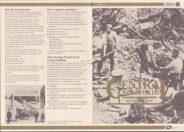
Document - CENTRAL GOLDFIELDS RESTORATION FUND, March 1986
Pamphlet on the Central Goldfields Restoration Fund issued by the Victorian Ministry for Planning and Environment. Includes a map of the central goldfields region, introduction by Jim Kennan (Minister) and 3 photographs. Also a description on how the fund operates and how to apply for assistance. An insert of 2 blank application forms. Photos show , Miners using a sluice at Tarnagulla c.1880. Cnr of Sturt and Lydiard Sts, Ballarat c.1880. E. Eberhard Cordial Factory at Clunes c.1890.Victorian Ministry for Planning and Environmentorganization, government, central goldfields, restoration fund, ministry for planning and environment, j. kennan, tarnagulla, ballarat, clunes. -
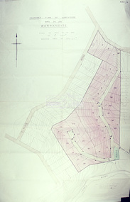
 Kew Historical Society Inc
Plan - Subdivision Plan, Pointed Firs Estate, 1936
The Kew Historical Society collection includes almost 100 subdivision plans pertaining to suburbs of the City of Melbourne. Most of these are of Kew, Kew East or Studley Park, although a smaller number are plans of Camberwell, Deepdene, Balwyn and Hawthorn. It is believed that the majority of the plans were gifted to the Society by persons connected with the real estate firm - J. R. Mathers and McMillan, 136 Cotham Road, Kew. The Plans in the collection are rarely in pristine form, being working plans on which the agent would write notes and record lots sold and the prices of these. The subdivision plans are historically significant examples of the growth of urban Melbourne from the beginning of the 20th Century up until the 1980s. A number of the plans are double-sided and often include a photograph on the reverse. A number of the latter are by noted photographers such as J.E. Barnes.An almost identical plan of the ‘Pointed Firs Estate’ is in the State Library of Victoria. The plan unusually uses a photograph to show the panoramic views from the Estate. A prospective purchaser could expect to look across the Yarra Valley to Eaglemont and Heidelberg. The 36 lots advertised for sale faced Doncaster Road, Houghton Street, Maud Street and Thackray Street in Balwyn North.subdivision plans - balwyn, pointed firs estate -
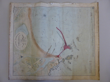 Warrnambool and District Historical Society Inc.
Map, Warrnambool Harbour 1879, 1879
This map shows the plans by eminent harbour engineer, Sir John Coode in 1879. Construction of the breakwater commenced in 1884 and was completed in 1890. Coode first visited Australia in 1872 when he commenced work with the Melbourne Harbour Trust to report on ways to improve Melbourne Port. He is considered one of the most eminent harbour engineers of the 19th century. His original plans for Warrnambool were revised because of cost but then subsequently found to be inadequate and later extended. This was not successful either and the harbour continues to have silting problems to this day. The Warrnambool Breakwater is of historical importance to Victoria and as this map depicts the original plans, it too has great historical significance. It is also significant with its association with Sir John Coode, who was one of the most important port engineers of the 19th century. He worked to improve ports along the Victorian coast including Portland, Geelong, Port Fairy and Lakes Entrance. While this map demonstrates the engineering skills of the era, it also reflects the limitations when natural elements are involved. Its Historical importance also lies in the depiction of items on the map which relate to Warrnambool’s early history. Paper on linen map coloured, and depicting the harbour area of Warrnambool with the proposed breakwater plan in red. It has Victorian Harbours information in oval at top of map. It shows depths of some areas.In oval at top, “Victorian Harbours Warrnambool plan to accompany Sir John Coode report dated 28th Feb 1879. Drawing No 2. Scale 500 feet to 1 inch at bottom centre. Sir John Coode signature in bottom left corner. A 33 A on bottom left reversesir john goode, warrnambool harbour map, warrnambool harbour map 1879, port of warrnambool map 1879 -
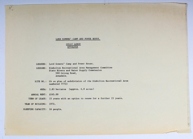 Melbourne Legacy
Plan - Document, plans, Lord Somers' Camp and Power House. Gully Lodge, Eppalock
Plans for the permanent camp site used by Melbourne Legacy in the second half of the 20th century.Most of the Junior Legatees would have stayed at Lord Somers' camp, which is still in use.6 photocopied plans and 1 cover sheet - A4 size - black on white, single sided.camp, lord somers camp, power house, eppalock -
Whitehorse Historical Society Inc.
Map, Blackburn East Primary School
Plans of Blackburn East Primary SchoolPlans of Blackburn East Primary School (1)1957; (2) Master Plan ; (3) Master Plan 1973. (4) Scheme F: Staff and administrative facilities 1974, Scale 1/8:1'Plans of Blackburn East Primary Schoolblackburn east primary school no. 4800, master plan, admin facilities -
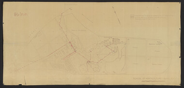 University of Melbourne, Burnley Campus Archives
Plan, School of Horticulture -Burnley, 1950
Same layout as plan at B91.0471, but showing PMG cables, and buildings existing, proposed and temporary or for demolitionPlan showing layout of PMG cables and PMG plant. Area bounded by Swan St., Yarra Boulevard, orchard, vegetable garden, market garden and S.W. Boundary to Stockman's Cottage. PMG layout handwritten. On same plan as B91.0484 (original) and B11.0383.burnley school of horticulture, orchard, gardens, vegetables, stockman's cottage -
Clunes Museum
Plan - ARCHITECTURAL DRAWINGS, BUTTER FACTORY CLUNES, C. 1894
PLAN OF CLUNES BUTTER FACTORYHAND DRAWN PLAN ON GLASS PAPER OF CLUNES BUTTER FACTORY INCLUDING ELEVATION AND SECTION A.B. SCALE 8FT TO 1 INCHclunes buildings, clunes butter factory -
 Melbourne Tram Museum
Document, Maidstone Tram Maintenance and Stabling Facility - Proposed Plans - Planning Approval
Provides the proposed plans for the Maidstone Tram Maintenance and Stabling Facility - Proposed Plans - Planning Approval stage - site plans, perspective, land use and sight lines from various locations. The information booklet looks at the project steps, planning approval, heritage issues, environmental, construction, timing and operations.Yields information about the proposed Maidstone tram depot.Digital copy of a 13 A3 page document titled - Maidstone Tram Maintenance and Stabling Facility - Proposed Plans - Planning Approval and a 12 A4 page Information booklettrams, maidstone, tramways, new depot -
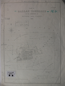 Ballan Shire Historical Society
Map - Map. Ballan Township, Plan of Ballan Township in the Counties of Bourke and Grant
The map is an early one of the township of Ballan showing street names and land owners.The map is significant in that it lists the owners of the house blocks within the township.A map showing the township and surrounding area of Ballan in 1856. Town streets are named as are the owners of the subdivided blocks of land. The map is a lithocopy and there is a scale in chains."D D Fraser" is written across the top of the map and "1856" is written in the near top right corner. There are other additions to the map but they are very difficult to decipher accurately or completely.ballan, ballan township map, ballan1856 -
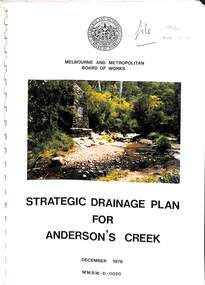 Ringwood and District Historical Society
Book, Strategic Drainage Plan For Anderson's Creek, 1978
Melbourne and Metropolitan Board of Works 1988 report on physical characteristics of Anderson's Creek and development of management strategies formulated in consultation with Cities of Croydon, Doncaster & Templestowe, and Ringwood, in which the Anderson's Creek Basin is located. Foreword by Alan H. Croxford, M.M.B.W. Chairman. -
Ringwood and District Historical Society
Equipment - Printers Blocks, Borough of Ringwood - Printers Blocks for Land Sales (Notice, and Plan). c1850s-60s, 1858
1 Text readsWitness Our Only and Well Beloved Son Sir Henry Berkly Knight Commander of the Most Honourable Order of the Bath, Captain General and Governor-in-Chief of our said Colony and --------- of the same, at Melbourne, Victoria, aforesaid the Eleventh day of May and the Twenty First Year of the Reign and in the Year of Our Lord One Thousand eight hundred and fifty eight.1 Printers block no. top left 1598 Heading : VICTORIA - LAND PURCHASE 2 Printers Block Borough of Ringwood -
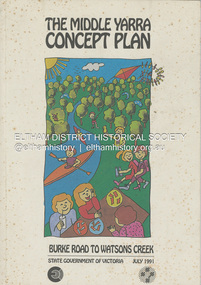 Eltham District Historical Society Inc
Book, State Government of Victoria, The Middle Yarra Concept Plan: Burke Road to Watsons Creek, July 1991
A draft concept plan developed for the Middle Yarra River between Burke Road and Watsons Creek which includes planning controls, developed and managed to meet the recreation and landscape objectives whilst protecting the natural resourcesa nd cultural heritage. It established a broad framework for more detailed plans and guidelines. Jointly produced by staff from the Victorian Department of Planning and Housing. July 1991.non-fictionA draft concept plan developed for the Middle Yarra River between Burke Road and Watsons Creek which includes planning controls, developed and managed to meet the recreation and landscape objectives whilst protecting the natural resourcesa nd cultural heritage. It established a broad framework for more detailed plans and guidelines. Jointly produced by staff from the Victorian Department of Planning and Housing. July 1991.recreation areas, regional planning, yarra river, watsons creek -
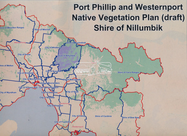 Eltham District Historical Society Inc
Book, Port Phillip and Westernport Native Vegetation Plan (draft), Shire of Nillumbik
Entire report available www.ppwema.vic.gov.au -
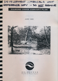 Eltham District Historical Society Inc
Book, Melbourne Parks & Waterways, Diamond Creek Concept Plan, June 1995
-
 Eltham District Historical Society Inc
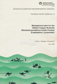
Book, Pat Vaughan, Management plan for the Eltham Copper Butterfly (Paralucia pyrodiscus lucida Crosby), (Lepidoptera: Lycasenidae); Arthur Rylah Institute for Environmental Researcg, Technical Report Series No. 79, July 1988
-
 Eltham District Historical Society Inc
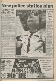
Newspaper - Newspaper article, Diamond Valley News, New police station plan by Jodie Haythorne, Diamond Valley News, November 30, p3, 1994
council amalgamation, shire of eltham, shire of montsalvat, shire of nillumbik, 1994, city of banyule, city of heidelberg, local government board, montsalvat, shire of diamond valley, police station, shire of eltham office site -
 Eltham District Historical Society Inc
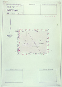
Slide - Photograph, Eltham Shire Council, Plan of Subdivision, Crown Allotment 8, Section 8A, Parish of Nillumbik,County of Evelyn, 1969
35mm colour positive transparency blue Agfacolour Service plastic mountC1, Pain, Sibbel and Carter, Research-Warrandyte Road, North Warrandyte, 4 August 1969carter, infrastructure, map, north warrandyte, pain, parish of nillumbik, plan of subdivision, planning, research-warrandyte road, sibbel, subdivison lots -
 Eltham District Historical Society Inc
Slide - Photograph, Eltham Shire Council, Plan of Subdivision of Part of Crown Allotment 4, Section 2 at Kangaroo Ground, Parish of Nillumbik, County of Evelyn, 1969
35mm colour positive transparency blue Agfacolour Service plastic mountC6, Kimse, Kangaroo Ground-St Andrews Road, 4 August 1969infrastructure, kangaroo ground, kangaroo ground-st andrews rd, kimse, map, plan of subdivision, planning, subdivison lots -
 Eltham District Historical Society Inc
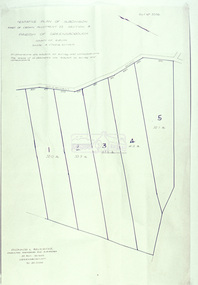
Slide - Photograph, Eltham Shire Council, Plan of Subdivision, Part of Crown Portion 3, Parish of Nillumbik, County of Bourke, 1969
35mm colour positive transparency blue Agfacolour Service plastic mountC5C, Delbridge, 4 lots, Rattray Road, 4 August 1969infrastructure, map, montmorency, planning, rattray road, subdivison lots, reichelt avenue -
 Eltham District Historical Society Inc
Slide - Photograph, Eltham Shire Council, Tentative plan of subdivision, part of Crown Allotment 22, Section B, Parish of Greensborough, County of Evelyn, 1969
35mm colour positive transparency blue Agfacolour Service plastic mountE11, N1069, Stogryn, Sub 'prop',infrastructure, map, planning, subdivison lots -
 Eltham District Historical Society Inc
Slide - Photograph, Eltham Shire Council, Proposed plan of subdivision, Mrs Du Lee, Warrandyte, 1969
35mm colour positive transparency blue Agfacolour Service plastic mountB2, Du Lee Subdivision, Research-Warrandyte Road, 4 August 1969infrastructure, map, planning, subdivison lots, du lee, glynns road, research-warrandyte road -
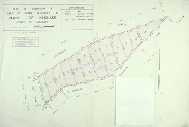 Eltham District Historical Society Inc
Slide - Photograph, Eltham Shire Council, Plan of subdivision of Part of Crown Allotment 41, Parish of Kinglake, County of Anglesey, 1969
35mm colour positive transparency blue Agfacolour Service plastic mountC8, N. Johnson, Kinglake-Glenburn Road, 4 August 1969infrastructure, map, planning, subdivison lots, n. johnson, kinglake-glenburn road, kinglake