Showing 3852 items
matching surveyed
-
 Federation University Historical Collection
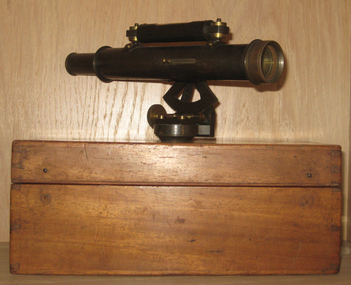
Instrument - Scientific Instrument, Drainage Level
Probably used for surveying courses at the Ballarat School of Mines Boxed telescopic sight with longitudu=inal bubble level and a quadrant draduated in +- 40 in 100 22mm diameter. Female screw thread base. Push-Pull focussing. Housed in an hinged timber box.drainage level, scientific intstruments, ballarat school of mines, scientific instruments -
 Moorabbin Air Museum
Document (Item) - Mirage Modifications Z 151-240
Description: Mirage Field Service Surveys Level of Importance: . -
Tatura Irrigation & Wartime Camps Museum
Surveyors Compass, Brush and Drummond Melbourne, 1920s
Owned by donor's father and used surveying for irrigation purposes.Round metal case containing magnetic compass needle, eyepiece and sighting hair. The sighting wire frame secures the neelde in a fixed position when depressed, complete with metal close fit lid and leather carrying pouch and strap.irrigation, surveying -
 Federation University Historical Collection
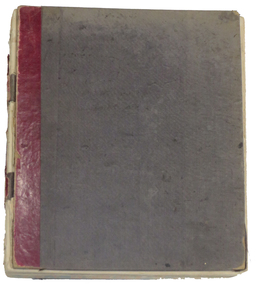
Book - Register, Ballarat School of Mines Library Register of Books, 1870-1896, 1870-1896
The listing of books in the Ballarat School of Mines library begins with No 1 and ends at No 1465. This book is identical to Library Catalogue No 00007, but isonly numbered to No. 921. Redmond Barry, Robert Broigh Smyth, Ferdinandy Von Mueller, the Victorian Geolofical Survey and many local illuminaries donated to the Ballarat School of Mines. Black cloth covered exercise book with handwritten lists of books in the Ballarat School of Mines Library dating from 1870 to 1896. The pages have been divided into columns with the following headings: Reg. No; Title; Author; Vol.; Issue; Donor, Receipt. Some of the books are as follows: 1. Memoirs of Geological Survey of Great Britain, Vol 1., 1846, Donated by Her Majesty's Government, 16/03/1870 19. Prospectus of the School of Mines, 1869, Donated by Her Majesty's Government, 16/03/1870 44. The Steam Engine, Rankine, purchased, 09/03/1871 72. Melbourne University Calendar, 1859-1860, donated by Sir Redmond Barry, 14/04/1871 85. Maps of County of Anglesey, donated by Minister of Mines, 23/05/1871 107. Electric Telegraph, R. Sabine, purchased, June 1874 356. Organic Constituents of Plants and Vegetable Substances, Dr. G.C. Willstein, donated by Ferdinand Von Mueller 375. The native Plants of Victoria Succinctly Defined, Baron Von Mueller, purchased, 1879 569. Platur's Manual of Qual and Quan Analysis with the blowpipe, donated by Henry Sutton, May 1884 738. German Bible, donated by R. J. Litton, 21.05.1886 802. Essays of Addison, J.R. Green, 18/06/1887, donated by Bella Guerin 803. Rec De Planches Dur Les sciences Les Arts Liberaux et les Arts Mechaniques, Vol VI, 1875, Donated by Theo William, 01/07/1887 Excel spreadsheet attached (incomplete)ballarat school of mines, library, books, ballarat school of mines library, william laplau, dr bunce, james oddie, bella guerin, j.f. usher, r.m. sergeant, redmond barry, robert brough smyth, cosmo newbery, john noble wilson, joseph flude, commissioner of patents, henry sutton, w.n. wooster, theophilus taylor, rivett henry bland, ferdinand von mueller, c.c. shoppee, william luplau, ferdinand krause, william wooster -
Stawell Historical Society Inc
Map, Borough of Stawell Parish of Stawell and Illawarra 10/06/1903, 10/06/1903
Department of Lands and Survey Map of Stawell with marked roads, allotments, physical landmarks. Found in Storage at ANZ Bank when the old archive was being cleaned out. Also shows Surveyed but unused roads. Showed where customers lived in StawellPholtolithograph Map - Paper on canvas backingBorough of Stawell. Parish of Stawell and Illawarra. County of Borong. Scale 8 Chains to 1 Inch. Scale 16 Chains to 1 Inch. Red Ink Writing, Purple and Blue.town -
 Bayside Gallery - Bayside City Council Art & Heritage Collection
Photograph, Department of Crown Lands and Survey, Victoria, Brighton, Brighton East and Bentleigh, c. 1965-71
The Department of Crown Lands and Survey (1857-1983) was responsible for the administration of survey and mapping and the sale, occupation and management of crown land throughout its existence. This aerial photograph shows parts of Brighton, Brighton East and Bentleigh and was taken circa 1965-71.brighton, department of crown lands and survey, aerial photograph, bayside, port phillip bay, map, cartographic material, bentleigh, brighton east, dendy park, dendy street, centre road, nepean highway, south road, football -
 Bendigo Military Museum
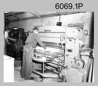
Photograph - Printer Technicians trimming printed map stock at the Army Survey Regiment, c1960s to c1980s
These six photographs of Printer Technicians using a heavy-duty guillotine to trim bulk printed map stock were probably taken circa 1960s to 1980s in Lithographic Squadron at the Army Survey Regiment, Fortuna, Bendigo. Personnel are not identified on Photos .3P and .4P, however names are annotated on photos .1P, .2P, .4P and .5P. Cartographers normally provided trim marks to specified map dimensions as guidance to the printer. The trimming stage, like all the other printing processes required high levels of accuracy. These guillotines were extremely powerful to cut through bulk quantities of printed maps, as evident in photos .1P .3P, .4P and .6P.This is a set of photographs of Printer Technicians using a heavy-duty guillotine to trim bulk printed map stock c1960s to 1980s. The photographs were printed on photographic paper and are part of the Army Survey Regiment’s Collection. The photographs were scanned at 300 dpi. .1) - Photo, black & white, c1960s, L to R: ‘Wanger’ Payne, unidentified, Lithographic Squadron .2) - Photo, black & white, c1980s, CPL Ken Cavanagh, Lithographic Squadron .3) - Photo, black & white, c1970s, unidentified, Lithographic Squadron .4) - Photo, colour, c1970s, Peter Saunders, Lithographic Squadron .5) - Photo, black & white, c1980s, L to R: unidentified, WO1 Noel ‘Nesty’ Coulthard, Lithographic Squadron .6) - Photo, black & white, c1980s, unidentified, Lithographic Squadron.1P, .2P, .4P and .5P. personnel annotation on back. * unidentified on .1P due to poor writing. .3P and .6P – no annotationroyal australian survey corps, rasvy, army survey regiment, army svy regt, fortuna, asr, litho, printing -
 Bendigo Military Museum
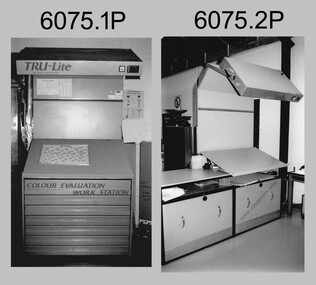
Photograph - Equipment used in Map Production at the Army Survey Regiment, 1991
These nine photographs of technical equipment were provided to the Directorate of Survey as input to the 1990-1991 Annual Report. The equipment in Photos .1P and .2P were used to evaluate/validate colour values on printed maps. The equipment in Photo .3P is a daylight film processor. The Optronix 5040 Laser Scanner/Plotter was shown in Photos .4P to .6P. The Print Room’s Map Handling Station in photo .7P provided ergonomic benefits to the Printer Technician and improved despatching productivity. The Optical Disk Archive and Retrieval System (ODARS) equipment in .8P was optical "platter" disk technology for the secure and long term archive storage of large amounts of digital map data. Map data was transferred from large reels of magnetic tape. As most map type (letters and names) generation was done in Automap 2, The ITEK Typesetter shown in photo .9P was close to obsolete in 1991. At this time it was used to generate map type for other RASvy units, contractors and sections still performing manual map production at Army Svy Regt.This is a set of photographs of Army Survey Regiment technical equipment taken in 1991. The photographs were printed on photographic paper and are part of the Army Survey Regiment’s Collection. The photographs were scanned at 300 dpi. .1) - Photo, black & white, 1991, Colour Evaluation Workstation No 1, Lithographic Squadron .2) - Photo, black & white, 1991, Colour Evaluation Workstation No 2, Lithographic Squadron .3) - Photo, black & white, 1991, Daylight film processor, Lithographic Squadron, Daylight Working Contacting Frames in background. .4) - Photo, black & white, 1991, Optronix 5040 Laser Scanner/Plotter, Lithographic Squadron .5) - Photo, black & white, 1991, Optronix 5040 Laser Scanner/Plotter, Lithographic Squadron .6) - Photo, black & white, 1991, Optronix 5040 Laser Scanner/Plotter, Lithographic Squadron .7) - Photo, black & white, 1991, Map Handling Station, Lithographic Squadron .8) - Photo, black & white, 1991, Optical Disk Archive and Retrieval System (ODARS), Cartographic Squadron .10) - Photo, black & white, 1991, Optronix 5040 Laser Scanner/Plotter, Lithographic Squadron .9) - Photo, black & white, 1991, ITEK Typesetter, Cartographic Squadron.1P, .2P, .4P to .10P – equipment description annotated on back .3P - no annotation.royal australian survey corps, rasvy, army survey regiment, army svy regt, fortuna, asr, litho, automap -
 Bendigo Military Museum
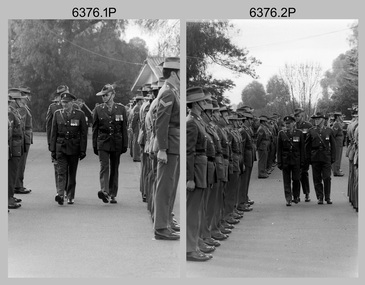
Photograph - Army Survey Regiment – Corps Day Parade and Defence Force Service Medal Presentations, Fortuna Villa, Bendigo, 1987
This set of 18 photographs were taken at a Corps Day Parade held at the Army Survey Regiment, Bendigo in July 1987. The Parade Commander was CO LTCOL Don Swiney MBE, and the Reviewing Officer was the Colonel Commandant (honorary appointment) of the Survey Corps - COL Clem Sargent (Retd). The Corps Day Parade was held to commemorate the 72nd anniversary of the formation of the Royal Australian Survey Corps. These photos comprise inspections of the Regiment’s four squadrons, presentations of the Defence Force Service Medal in recognition of 15 years of efficient remunerated service to SSGT Phil Meagher and SGT Wayne Rothwell; and formal group photos of each of the four Squadrons, Officers, and Warrant Officers/Sergeants. See Item 6375.36P for additional photographs taken at the start of the Corps Day Parade, drill movements of the four Squadrons forming up on the parade ground and the formal arrival of the Reviewing Officer.This is a set of 18 photographs of a Corps Day Parade held at the Army Survey Regiment, Fortuna, Bendigo in July 1987. The black & white photographs are on 35mm negative film and are part of the Army Survey Regiment’s Collection. The photographs were scanned at 96 dpi. .1) - Photo, black & white, July 1987. Headquarters Squadron inspection. L to R: unidentified (x3), COL COMDT COL Clem Sargent, CO LTCOL Don Swiney MBE (obscured), OC MAJ Roger Rix. .2) - Photo, black & white, July 1987. Lithographic Squadron inspection. L to R: unidentified, CPL Brian Paul, CPL Gary Tremain, CPL Warren ‘Waldo’ Shirley, unidentified, CPL Stuart Ridge, SSGT Rob Bogumil, SSGT Steve Egan. CPL Roy Hicks, unidentified, COL COMDT COL Clem Sargent, CO LTCOL Don Swiney MBE, OC MAJ Mick Byrne, remainder unidentified. .3) - Photo, black & white, July 1987. Air Survey Squadron inspection. L to R: OC Daryl Hockings CSM, COL COMDT COL Clem Sargent, CO LTCOL Don Swiney MBE, SGT Graham Johnson, unidentified (x4), SGT Lyn Johnson, CPL Steve Rundle, SGT Wayne Rothwell, SGT Bruce Hammond, SGT Barrie Craymer, SPR Brett Parkin .4) - Photo, black & white, July 1987. Cartographic Squadron inspection. L to R: OC MAJ Bob McHenry, COL COMDT COL Clem Sargent, CO LTCOL Don Swiney MBE, CPL Rod Skidmore, SSGT Phil Meagher, SPR Craig Kellet, unidentified, CPL Col McInnes, SPR Nick Cowan, unidentified, CPL Jeff Le-Fevre, SPR Richard Arman, CPL Dan Cirsky, SPR Tom Bloxham, CPL Peter Johnson, unidentified. .5) - Photo, black & white, July 1987. Presentation of Defence Force Service Medal. L to R: WO2 Andy Wilson, COL COMDT COL Clem Sargent, MAJ Terry Edwards, SSGT Phil Meagher, CAPT John South (background). .6) - Photo, black & white, July 1987. Presentation of Defence Force Service Medal. L to R: COL COMDT COL Clem Sargent, SGT Wayne Rothwell, SSGT Phil Meagher, MAJ Roger Rix (background). .7) - Photo, black & white, July 1987. Corp Day Parade guests. L to R: MAJ Duncan Burns, SPR Dianne (Thomas) Soutar, unidentified guests, CPL Kevin ‘Chuck’ Berry, CPL Graeme Priestley, unidentified guests. .8) - Photo, black & white, July 1987. Corp Day Parade guests. L to R: unidentified guests, George Austen, SPR Dianne (Thomas) Soutar, Bob Mason, unidentified guests, CPL Graeme Priestley, unidentified guests, SGT Terry Danger, unidentified guests, CO LTCOL Don Swiney MBE (facing away), COL COMDT COL Clem Sargent. .9) & .10) - Photo, black & white, July 1987. L to R: unidentified guest, COL COMDT COL Clem Sargent, CO LTCOL Don Swiney MBE. .11) - Photo, black & white, July 1987. L to R: unidentified guests, 2IC MAJ Terry Edwards, ADJT CAPT Andrew McLeod. .12) - Photo, black & white, July 1987. WO1 Bob ‘Stretch’ Hayden. .13) - Photo, black & white, July 1987. Lithographic Squadron. Back Row L to R: CPL Paul Baker, CPL Greg Rowe, CPL Kerron South, CPL Stuart Ridge, SPR Rob Jones, CPL Laurie Justin, unidentified, SPR Geoff Webb, unidentified (x2) SPR Shona Hastie, SPR Trevor King, LCPL John Bateman, CPL Ken Peters, CPL Roy Hicks. Middle Row L to R: CPL Brian Paul, unidentified (x2), CPL Jim Ash, CPL Dale Hudson, CPL Gary Tremain, unidentified, LCPL Daryl South, CPL Graham Hales, SPR Bob Bousfield, CPL John ‘Flash’ Anderson, CPL Peter Dillon, CPL Peter Swandale, SPR Colin Yeats, CPL Lance Strudwick. Front Row L to R: CPL Warren ‘Waldo’ Shirley, SGT Gary Kerr, SGT Brian Fauth, SGT Graham Johnston, SSGT Steve Egan, WO2 Bill Jones, OC MAJ Mick Byrne, WO2 Ralph Chant, SSGT Rob Bogumil, unidentified UK exchange, SGT Alan Virtue, SGT Jeff Willey. .14) - Photo, black & white, July 1987. Headquarters Squadron. Back Row L to R: CPL Bob Thrower, PTE Mark Twiss, unidentified (x3), LCPL Bob Sheppard, unidentified, SGT Ian Belmont, SPR Peter Coles, SPR Tracy (Parker) Ash, CPL Steve McGuinness, SGT Bob Garritty, unidentified officer. Middle Row L to R: WO1 Doug Arman, WO2 Kevin Macquire, W01 Noel ‘Nesty’ Coulthard, WO1 Allan Adsett, WO2 Andy Wilson, CPL David Jobe, SGT Kevin Boehm, unidentified (x3), SSGT Greg Gilbert, WO2 George Graham, WO2 Dave Miles, WO2 Ted Burgess, WO1 Ken Slater. Front Row L to R: WO1 Bob ‘Stretch’ Hayden, CAPT Peter ‘Blue’ Blaskett, CAPT Bob Williams, ADJT CAPT Andrew McLeod, 2IC MAJ Terry Edwards, Acting RSM WO1 Dave Thompson, CO LTCOL Don Swiney MBE, OC MAJ Roger Rix, WO2 Alan Bunn, MAJ Duncan Burns, CAPT John South, LT Vicky Thompson, WO1 Peter Warwick. .15) - Photo, black & white, July 1987. Air Survey Squadron. Back Row L to R: SGT Lyn Johnson, CPL John ‘Toad’ Smith, SGT Roger Rees, SGT Wayne Rothwell, CPL Roger Pearson, SPR Leah (Hoffman) Peppler, unidentified, SPR Christine Gordon, SPR Jodi Bowman, SGT Paul Leskovec CSM, SPR Tony Jackson, CPL John Reid, unidentified, SPR Avril (Bray) Lloyd? SPR Diane (Thomas) Soutar, SSGT Brian Collings. Middle Row L to R: unidentified, SGT John ‘Stormy’ Tempest, CPL Perry Burt, SPR Rick Millar, CPL Graeme Priestley, SGT Bruce Hammond, CPL Max Watson, SPR Brett Parkin, SPR Peter Ball, CPL Dick Warsing, SPR Sue (Foote) Bourne, SPR Sandy Wynn, CPL Steve Hill OAM CSM, CPL Steve Rundle, CPL Andy Mallon, SPR Stafford Lester, SPR Steve Moss, CPL Rod Burton. Front Row L to R: SGT Ken Talbot-Smith, SSGT Phil Boyle, SSGT Max Coletti, WO2 Peter Tangey, LT Brian Sloan, WO1 Stevo Hinic, OC Maj Daryl Hockings CSM, CAPT Laurie Newton, WO1 Denis Marshall, SSGT Neil ‘Ned’ Kelly, SSGT Dennis McCarthy, SSGT Adrian ‘Charlie’ Creedy, SGT Barry Craymer, SSGT John ‘Shep’ Shephard. .16) - Photo, black & white, July 1987. Cartographic Squadron. Back Row L to R: unidentified, SPR Michelle Griffith, unidentified, SPR Raelene Munting, unidentified, SPR Ailsa (Sorby) Miller, SPR Kasey Northausen, CPL Lorraine (Daly) Talbot-Smith, SGT John Bettridge, SPR Richard Arman, CPL Colin McInnes, CPL Mick ‘Buddha’ Ellis, SPR Mark Donnelly, CPL Steve Coulson, LCPL Rick Millar, CPL Jeff Le-Fevre. 3rd Row L to R: CPL Paul Trent, unidentified, CPL Brian Johnson, CPL Peter Johnson, CPL Rod Skidmore, SPR Chad Hardwick, LCPL John Lane, LCPL Ken Dempster, unidentified CPL Dan Cirsky, SPR Ross Collishaw, SPR Craig Kellet, CPL Greg Sulman, SPR Tom Bloxham, SPR Ben Lucas. 2nd Row L to R: SPR Jim Humphrey, CPL Pat Drury-Lane, SPR Max Shaw, SPR Barry Hogan, unidentified, CPL David Murphy, SPR Ian Hill, SPR Bruce Graham, CPL Greg Honan, SPR Nick Cowan, CPL Steve Throssel, SPR Ben Tarasenko. Front Row L to R: SGT Eddy Jacobs, SGT Phil Smalley, SGT Rick Van der Bom, SSGT Phil Meagher, SSGT Allan Brown, WO1 Colin Cuskelly, WO2 Pat Lumsden, OC MAJ Bob McHenry, unidentified officer, WO2 Neville Stone, SSGT Ian ‘Rock’ Thistleton, SGT Martin Evans, SGT Terry Danger, SGT Bob Bright. .17) - Photo, black & white, July 1987. Sergeants Mess. Back Row L to R: SGT Graham Johnston, SGT Brian Fauth, SGT Gary Kerr, SGT Alan Virtue, SSGT Rob Bogumil, SSGT Brian Collings, SGT Roger Rees, SGT Phil Smalley, SGT Rick Van der Bom, SGT Martin Evans, SGT Bob Garritty, SSGT Phil Boyle, SGT John ‘Stormy’ Tempest, SSGT Allan Brown, SSGT Max Coletti, SSGT Neil ‘Ned’ Kelly, SSGT Dennis McCarthy. 3rd Row L to R: SGT Bruce Hammond, SGT Wayne Rothwell, SGT Eddy Jacobs, unidentified UK exchange, SSGT Steve Egan, SGT Bob Bright, SSGT Ian ‘Rock’ Thistleton, SGT Paul Leskovec CSM, SGT Barry Craymer, SSGT Greg Gilbert, SGT Kevin Boehm, Terry Danger, SGT Ken Talbot-Smith, WO2 Ted Burgess. 2nd Row L to R: WO2 Ralph Chant, WO2 Andy Wilson, WO2 Bill Jones, WO2 Alan Bunn, SGT John Bettridge, SSGT Adrian ‘Charlie’ Creedy, SGT Lyn Johnson, SSGT Phil Meagher, SSGT John ‘Shep’ Shephard, WO2 Kevin Macquire, WO2 Peter Tangey, WO2 Dave Miles, WO2 George Graham, WO2 Pat Lumsden, SGT Ian Belmont. Front Row L to R: WO1 Colin Cuskelly, Acting RSM WO1 Dave Thompson, WO1 Denis Marshall, 2IC MAJ Terry Edwards, WO1 Peter Warwick, CO LTCOL Don Swiney MBE, WO2 Neville Stone, WO1 Bob ‘Stretch’ Hayden, , W01 Noel ‘Nesty’ Coulthard, WO1 Stevo Hinic, WO1 Ken Slater, WO1 Allan Adsett. .18) - Photo, black & white, July 1987. Officers Mess. Back Row L to R: CAPT Laurie Newton, LT Brian Sloan, unidentified officer, CAPT John South, CAPT Peter ‘Blue’ Blaskett, CAPT Bob Williams, LT Vicky Thompson, unidentified officer, CAPT Andrew McLeod. Front Row L to R: MAJ Daryl Hockings CSM, MAJ Mick Byrne, MAJ Bob McHenry, COL COMDT COL Clem Sargent, CO LTCOL Don Swiney MBE, MAJ Terry Edwards, MAJ Roger Rix, MAJ Duncan Burns. .1P to .18P – There are no personnel identified.royal australian survey corps, rasvy, army survey regiment, army svy regt, fortuna, asr -
 Bendigo Military Museum
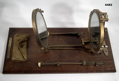
Instrument - Heliograph Mk V Training Aid - circa 1912, 1912
The Heliograph MkV is a fascinating piece of historical surveying and communications equipment. It was primarily used for visual signaling by reflecting sunlight with a mirror to send coded messages over long distances. This method was primarily useful in remote areas where other forms of communication were not available. The MkV model, specifically, was widely used by the British Army and other military forces from around 1906 until the mid 1960s. It remained in use with the Australian Army Survey Corps until the mid 1980s. The device typically included a 5 - inch mirror and was often mounted on a tripod for stability. Initially the instrument was used to communicate between survey stations using Morse code to coordinate their activities. Later when better forms of communication were available they were used for precise angle alignment where the sunlight reflection from the mirror was targeted between the survey stations to give very accurate results. The MkV was relatively light weight and portable, making it ideal for use in the field. It could be setup and adjusted quickly. The heliograph had an adjustable mirror that could be tilted to reflect sunlight towards a distant receiver. Surveyors could align the mirror using a sighting device. Whilst it was primarily used by the Military it was also used in civil surveying particularly in the remote areas of Australia. This instrument was used as a training aid to help teach surveyors at the Royal Australian Survey Corps School of Military Survey. Catalog item No 2009 is a tripod that was used to mount the Heliograph whilst being used for surveying.A Heliograph containing two mirrors with brass surrounds mounted on a wooden board as a Training Aid. Item has additional parts attached to the base board."Heliograph Mk V Training Aid"royal australian survey corps, rasvy, fortuna, army survey regiment, army svy regt, asr -
 Bendigo Military Museum
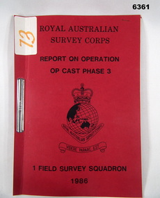
Administrative record - Operation Op Cast Phase 3 1986 - Operation Report, 1 Fd Svy Sqn
This is a report on the Royal Australian Survey Corps Survey Operation to Field verify two 1:50,000 maps 9541-3 TYALGUM and 9541-2 GREVILLIA conducted by 1 Fd Svy Sqn during the period 8 Nov -20 Nov 1986.Red light Cardboard Covers containing an 8 x page paper report held together with and ARNOS Fastenerroyal australian survey corps, rasvy, fortuna, army survey regt, army svy regt, asr -
 Bendigo Military Museum
Photograph - Army Survey Regiment Open Day, Fortuna, Bendigo, 1982
This is a set of 25 photographs of an Open Day held at the Army Survey Regiment, Bendigo in 1982. Although most of the photos were taken outdoors, a technical tour may have been conducted through the production areas of Air Survey, Cartographic and Lithographic Squadrons. .1) - Photo, black and white, 1982. Unidentified civilian visitors. CO LTCOL Peter Eddy on right. .2) - Photo, black and white, 1982. Unidentified personnel and civilian visitors. .3) &.4) - Photos, black and white, 1982. Unidentified personnel and civilian visitors, SPR Janet (Chopping) Justin, .5) - Photo, black and white, 1982. Unidentified personnel and civilian visitors. .6) - Photo, black and white, 1982. Unidentified personnel and civilian visitors by CPL Le-Anne (Smallshaw) Shirley. .7) to .10) - Photos, black and white, 1982. Unidentified personnel and civilian visitors. .11) - Photo, black and white, 1982. Unidentified personnel and civilian visitors. Centre of photo - Bendigo Lord Mayor Dr. Joseph Pearce, CO LTCOL Peter Eddy on right. .12) - Photo, black and white, 1982. Unidentified personnel and civilian visitors. Bendigo Lord Mayor Dr. Joseph Pearce delivers his speech. .13) to .14) - Photos, black and white, 1982. Unidentified civilian visitors. Centre of photo - Bendigo Lord Mayor Dr. Joseph Pearce delivers his speech, CO LTCOL Peter Eddy on right. .15) - Photo, black and white, 1982. Unidentified personnel and civilian visitors. Bendigo Lord Mayor Dr. Joseph Pearce delivers his speech. .16) - Photo, black and white, 1982. Unidentified civilian visitors. CO LTCOL Peter Eddy delivers his speech. .17) - Photo, black and white, 1982. Unidentified civilian visitors. Unidentified dignitary delivers his speech. .18) - Photo, black and white, 1982. CO LTCOL Peter Eddy leads unidentified civilian visitors and Bendigo Lord Mayor Dr. Joseph Pearce to Fortuna’s front steps. .19) &..20) - Photos, black and white, 1982. CO LTCOL Peter Eddy on Fortuna’s front steps briefs Bendigo Lord Mayor Dr. Joseph Pearce and unidentified civilian visitors. .21) - Photo, black and white, 1982. CO LTCOL Peter Eddy on briefs Bendigo Lord Mayor Dr. Joseph Pearce and unidentified civilian visitors in Fortuna’s front foyer. .22) &..23) - Photos, black and white, 1982. Unidentified pipes and drums band. .24) &..25) - Photos, black and white, 1982. CPL Megan (McBurney) Reynolds briefs unidentified civilian visitors at the front of Fortuna Villa near the Pompeii Fountain.royal australian survey corps, rasvy, army survey regiment, army svy regt, fortuna, asr -
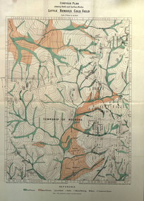 Federation University Historical Collection
Book, Report on the Little Bendigo or Nerrena Gold-Field, Ballarat, 1901, 1901
Blue soft covered foolscap book of 4 pages. The book includes a folded, colour contour plan shewing reefs and Surface Works Little Bendigo Gold Field and an Underground Survey of Mines, Metropolitan, Monte Cristo Linelittle bendigo, nerrena, h.s. whitelaw, william baragwanath, geology, monte christo, monte cristo, neerena, nerrina, plans, mining cgt -
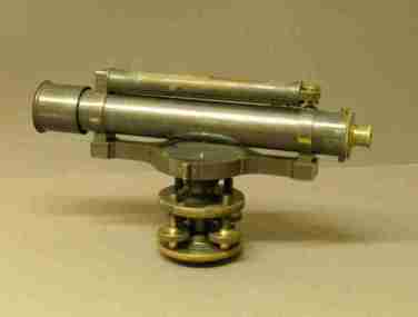 Federation University Historical Collection
Equipment - Scientific Instruments, Level (Dumpy)
Surveying level - long bubble level on top. Magnet, compass under telescope. No crosshairs. External focussing. Four levelling screws. No transverse level. Housed in a polished timber storage box. Fits tripod Catalogue Number 429.scientific instruments, level, dumpy -
Bendigo Historical Society Inc.
Map - NEILBOROUGH : COUNTY OF BENDIGO, 13-10-27
Map. Neilborough, County of Bendigo, Tandarra, Whirrakee, Huntly, Nerring, Yarraberb, Yallook, Photo-Lithographed at the Department of Lands and Survey, Melbourne by W.J. Butson 13-10-27, Price 1/- (number 77 in map cupboard 1)W.J. Butson.map, bendigo, neilborough -
Bendigo Historical Society Inc.
Map - MANDURANG : COUNTY OF BENDIGO, 1962
Map. Mandurang, County of Bendigo. Sandhurst, Strathfieldsaye, Sedgwick, Lockwood. By authority A.C. Brooks, Government Printer, Melbourne. Drawn and Reproduced at the Department of Lands and Survey, Melbourne, 1962, Price 2/-. (number 67 in map cupboard 1)A.C. Brooks, Government Printer, Melbourne.map, bendigo, mandurang -
Bendigo Historical Society Inc.
Map - TALAMBE : COUNTY OF BENDIGO, 21-3-27
Map. Talambe, County of Bendigo, Hayanmi, Calivil, Pompapiel, Yallook, Tandarra, Dingee. Photo-Lithographed at the Department of Lands and Survey, Melbourne, by W.J. Butson 21-3-27, Price 2/-. (number 27 in map cupboard 1)W.J. Butsonmap, bendigo, talambe -
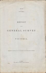 Bendigo Historical Society Inc.
Document - VICTORIA SURVEY REPORT 1859 TO 60
Four page report presented to both houses of parliament by Surveyor General CH W Ligar dated 1859-60. Object of survey to establish the best method of delineating the boundaries of new allotments in the colony. Geodetic method recommended.bendigo, history, allottment survey -
Bendigo Historical Society Inc.
Map - CAMPBELL COLLECTION: BENDIGO AND DISTRICT MAPS, 11-2-37
Map. Parish of Shelbourne, County of Bendigo. Scale 40 chains to 1 inch. Drawn and reproduced at the Department of Lands and Survey, Melbourne, Victoria. Price 2/-.11-2-37. By Authority H.J. Green, Government Printer, Melbourne.H.J. Green, Government Printermap, bendigo, agricultural lands -
Bendigo Historical Society Inc.
Map - EPPALOCK : COUNTY OF BENDIGO, 2-11-14
Map. Eppalock, County of Bendigo,Lyell, Sedgwick, Strathfieldsaye, Axedale, Knowsley, Kimbolton. Photo-Lithographed at the Department of Lands and Survey, Melbourne by W.J. Butson, 2-11-14. Price 1/-. (number 39 in map cupboard 1)W.J. Butson.map, bendigo, eppalock -
Bendigo Historical Society Inc.
Map - YARRAYNE : COUNTY OF BENDIGO, 6-1-32
Map. Yarrayne, County of Bendigo, Janiember East; Pompapiel, Salisbury, Bridgewater, Salisbury West, Powlett. Photo-Lithographed at the Department of Lands and Survey, Melbourne. Price 2/-. 6-1-32. (number 12 in map cupboard 1)H.J. Green, Government Printermap, bendigo, yarrayne -
Bendigo Historical Society Inc.
Map - PANNOOMILLOO : COUNTY OF BENDIGO, 1957
Map. Pannoomilloo, County of Bendigo, Milloo, Warragamba, Diggorra, Pannoobamawm. Drawn and reproduced at the Department of Lands and Survey, Melbourne,1957. Price 2/-. By Appointment W.M. Houston, Government Printer, Melbourne. (number 3 in map cupboard 1)W.M. Houston, Government Printermap, bendigo, pannoomilloo -
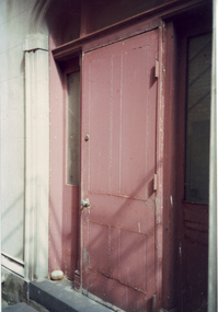 Villa Alba Museum
Photograph - Painted external door, c.1987
Built for William and Anna-Maria Greenlaw in the early 1880s, and with interiors decorated by the Paterson Bros, Villa Alba remained in private ownership until 1949. From 1950, the house was owned by a number of institutions. By 1984, the Villa Alba Preservation Society had been formed, and three years later, the Mount Royal Hospital granted a 25-year lease to Kew Council. In 2004, the title to Villa Alba was passed by the Victorian Government to The Villa Alba Museum Incorporated. The Museum, at 44 Walmer Street, Kew, is now a cultural institution committed to the collection, study and display of 19th century interior decorative finishes, and the components of 19th and 20th century interior decoration.This is one of a number of historically and aesthetically significant photos of the interiors and exterior of Villa Alba when it was still owned by the Mount Royal Hospital, showing twentieth century accretions and deterioration of the historic fabric of the building. This was a benchmark survey against which future conservation and restoration activities can be measured.In December 1987, Mockridge Stahle & Mitchell Pty Ltd Architects prepared ‘Villa Alba Survey: A Report on the fabric for Mount Royal Hospital’ of which this photograph is a part. Photo of a raised painted wooden door at the back of Villa Alba.villa alba museum, conservation photographs, victorian architecture, external doors -
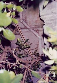 Villa Alba Museum
Photograph - Exterior pipe obscured by foliage, c.1987
Built for William and Anna-Maria Greenlaw in the early 1880s, and with interiors decorated by the Paterson Bros, Villa Alba remained in private ownership until 1949. From 1950, the house was owned by a number of institutions. By 1984, the Villa Alba Preservation Society had been formed, and three years later, the Mount Royal Hospital granted a 25-year lease to Kew Council. In 2004, the title to Villa Alba was passed by the Victorian Government to The Villa Alba Museum Incorporated. The Museum, at 44 Walmer Street, Kew, is now a cultural institution committed to the collection, study and display of 19th century interior decorative finishes, and the components of 19th and 20th century interior decoration.This is one of a number of historically and aesthetically significant photos of the interiors and exterior of Villa Alba when it was still owned by the Mount Royal Hospital, showing twentieth century accretions and deterioration of the historic fabric of the building. This was a benchmark survey against which future conservation and restoration activities can be measured.In December 1987, Mockridge Stahle & Mitchell Pty Ltd Architects prepared ‘Villa Alba Survey: A Report on the fabric for Mount Royal Hospital’ of which this photograph is a part. Photo of cast exterior water pipe party obscured by vegetation.villa alba museum, conservation photographs, victorian architecture, drain pipes -
Clunes Museum
Map - MAPS/ DOCUMENTS, CIRCA 1857
COLLECTION OF DOCUMENTS (COPIES OF10 MAPS AND DIAGRAMS OF TOURAAL PURCHASED UNDER PREEMPTIVE RIGHT BY DONALD CAMEROM 17TH FEBRUARY, 1857. COUNTY OF TALBOT - GOLDFIELD'S SURVEY PLAN NO.1 CLUNES COUNTY OF TALBOT. GLENDONALD - CRESWICK/CLUNES.local history, mining -
Clunes Museum
Document - REPORTS
E J Dunn described the geology of the mining in an around Clunes and a recommendation for re-commencing mining operations in Clunes 1909.1 PHOTOCOPY OF A PAGE SHOWING RETURNS MADE BY MINING SURVEYORS AND REGISTERS TAKEN FOR THE QUARTER ENDED 31ST MARCH 1875 .2 & .3 PHOTOCOPY OF TWO PAGES OF A GEOLOGICAL SURVEY COMPLETED FOR THE GOVERNMENT (SENT IN 17/5/1909)NILlocal history, document, mining -
Whitehorse Historical Society Inc.
Map, Nunawading, 1972
Variation of original 1864 map with a number of additions and bold marking of an area including Forest Hill, Vermont and Vermont South as 'Proclaimed survey area No 21 May 1972 2826. Marked as P M Noting Melb SeriesVariation of original 1864 map with a number of additions and bold marking of an area including Forest Hill, Vermont and Vermont South as 'Proclaimed survey area No 21 May 1972 2826. Marked as P M Noting Melb Series.Variation of original 1864 map with a number of additions and bold marking of an area including Forest Hill, Vermont and Vermont South as 'Proclaimed survey area No 21 May 1972 2826. Marked as P M Noting Melb Seriesmaps, shire of blackburn and mitcham, forest hill, vermont, vermont south -
 Whitehorse Historical Society Inc.
Letter - Document, Roads, 1/04/1868
Letter to C. Hodgkinson, Assistant Commissioner of Lands Survey from William H. Watkins, Bailiff of Crown Lands, dated 1 April 1868 re alternative locations of road through Messrs Cook or Cummings land in Nunawading.marshall's gully, cook, william, cumming (mr), watkins, william h, hodgkinson, clement, roads and streets -
 Otway Districts Historical Society
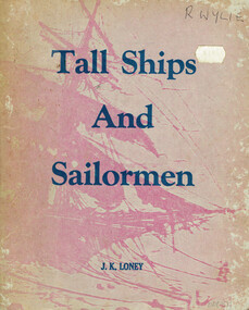
Book, J.K. Loney, Tall ships and sailormen
Compiled from newspapers, official records, registers, books and unpublished diaries Tall ships and sailormen provides information for those interested in the marine history of Victoria.Tall ships and sailormen. A concise survey of Victoria's early maritime history. J.K. Loney. nl; J.K. Loney; nd. ii, 103 p.; illus, maps, bibliography. Soft cover. ISBN 0 909244 02 2victoria; ships; sailors; j.k. loney; history; -
Bendigo Historical Society Inc.
Plan - MARKS COLLECTION: PLAN OF UNDERGROUND WORKINGS CINDERELLA COMPANY, JOHNSON'S REEF
Plan on heavy parchment paper: on top of plan 'Plan of the underground workings Cinderella Company, Johnson's Reef' Lh side of plan 'Kent Company's Ground' on bottom: Tipper and Company. Written on bottom surveyed 13/7/64.bendigo, mining, cinderella company