Showing 4893 items matching "black hills"
-
 Ringwood and District Historical Society
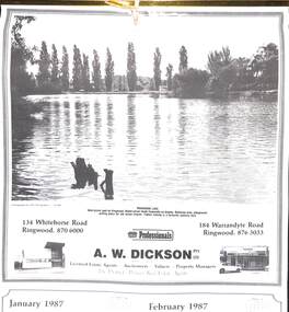
Souvenir - Complimentary A.W.Dickson Real Estate Agents calendars, Complimentary A.W.Dickson Real Estate Agents calendars - 1987 and 1988.1987 calendar with photographic images of local Ringwood features and 1988 calendar featuring local Ringwood land sale promotional images from early 20th Century
A.W.Dickson was a Real Estate Agent in Ringwood for many years. These calendars show the local buildings of the day. For example the original Eastland 's building of 1967, Maroondah Hospital 1976 and the Civic Centre now the Karralyka Centre.1 1987 calendar with six black and white photos of buildings and vistas around Ringwood with monthly dates in lower quarter of page. 2 1988 calendar with six posters advertising early 20th century land sales in Ringwood, Heathmont and Ringwood East with dates in lower quarter of page Compiled by A.W.Dickson Pty. Ltd. Real Estate Agent. Photographed by C.M.S. Photographers - 725 9441 (January February 1987) RINGWOOD LAKE - Ideal picnic spot for Ringwood Model power boats frequently on display. Barbecue area, playground, resting place for old steam engine. Yabbie netting is a favourite pastime here. (March April 1987) CLOCK TOWER - Moved from its former site on Warrandyte Road corner in 1967 and re-built in its present location, brick by brick. A wreath laying ceremony is held here on Anzac day each year. (May June 1987) RINGWOOD AQUATIC CENTRE - A world class swimming facility opened in 1986 at a cost of $3 million. Featuring the latest ozone water treatment techniques. In summer folding doors can be opened to give access to existing outdoor pools and sunbathing area. (July August 1987) MAROONDAH HOSPITAL - Opened in 1976 after many years of fund raising efforts by local people. The opening of casualty facilities was welcomed by locals as previously Box Hill Hospital catered for the entre area. (September October 1987) EASTLAND - Opened October 1967. Built on a former football oval. Now about to undergo major extensions to cater for Ringwood's population growth into the 21st Century. November December 1987 CIVIC CENTRE - Built on the site of a former antimony mine behind the council offices. Now the venue for many activities and a local point for Ringwood's Cultural Life. -
 Ringwood and District Historical Society
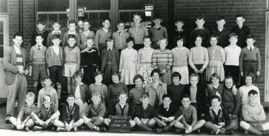
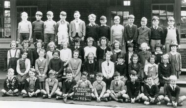
Photograph, Ringwood State School -Class photograph - Grade 5A, 1956
Black and white photograph - Grade 5A, 1956"Attached to photograph" Back Row- L to R: Wally Zielinski, Lylle Reeves, Mal Corin, T Cartright, Terry Segren, Kevin Burden, Wayne Ennis, ?, B James, Ian Simpson, Arthur Wigley, Doug Sjorgren. 2nd Row - L to R: Ian McLeave, Neal McCarten, Tom Guest, Margaret Cleator, Helen Bird, June Robinson, Marg Allsop, Susanne King, Olwyn Hayes, Lynette Broadway, ?, Alan Byrne, Maurice Johnson. 3rd Row - L to R: Lawrence Sumpter, Janice Bomford, Glenys Paul, Rhonda Thompson, Anita Hill, Pat Carpenter, Carol Pavey, Erica Burns, Lorraine Guscott, Angela Ochram, Kathleen Haywood. Front Row - L to R: Stan Bjerking, Ian Marshall, Barry Cooper, Robin Harris, Les Pattendon, Rod Clutterbuck, Kevin Divola, Kenny Gowers, Terry Wood, Ian Wilton. Absent - Dawn Riedel Teacher: Mr Reid. -
 Ringwood and District Historical Society
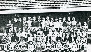
Photograph, Ringwood State School -Class photograph - Grade 4A, 1955
Black and white photograph - Grade 4A, 1955"Attached to photograph" Back Row- L to R: M Corin, T Seagren, I Weist, D Sjogren, I Simpson, B Steegstra, B Cain, N Miller, ? Fitzpatrick, P Hill, ?, G Frazer, B Short, T Coutes, B Stevenson, P White, ?. 2nd Row - L to R: M Johnson, R Harris, S Dorman, H Trout, ?, W Marriner, ?, F Hackett, ?, ?, ?, L Corbett, R Thompson, V Pincock, I Wilton, L Sumpter. 3rd Row - L to R: I Marshall, N Maclarty, C Pavey, F Lillywhite, E Dexter, S King, ?, M Milne, ?, H Boyle, ?, B Stewart, J Smalley, K Sterling, Olwyn Hayes, ?, ?, I Clarksen. Front Row - L to R: D Richards, B Bangay, A Byrne, B Cooper, D Bolton, J Forbes, R Jenkins, R Albert, R Galfred, ?. Teacher: Mr Smith -
 Ringwood and District Historical Society
Photograph, Ringwood State School -Class photograph - Grade 1C, 1951
Black and white photograph - Grade 1C, 1951"Attached to photograph" Back Row- L to R: (?) Oliver, (?) Oliver, John Pottenger, Gary Stewart, ?, ?, Lyndan McKeon, Terry Riley, ?, ?, Ken (?), Peter Tindal. 2nd Row - L to R: Anne Wausherson, ?, Faye Marshall, ?, Carol Hancy, Carol Hampson, Carol Pavey, Diane Close, Sylvia Johnson, Meryn Longmrye. 3rd Row - L to R: Margaret Strachan, Jennifer Young, Ailsa Ralston, Judith Bower, Mary Lloyd, ?, ?, ?, Judith Hill, Phylis Hagen, Annette Harns. Front Row- L to R: Murray Coulthard, Ray Brown, ?, ?, Peter Connell, ?, Robert Morris. Teacher: -
 Ringwood and District Historical Society
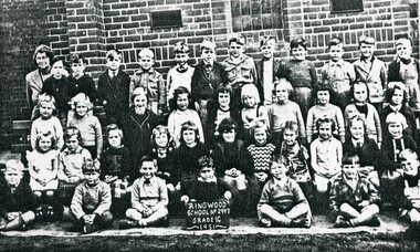
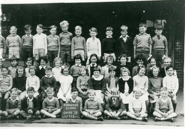
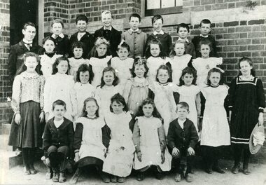
Photograph, Ringwood State School - Class photograph - Grade 2B, 1953
Black and white photograph - Grade 2B, 1953"Attached to photograph" Back Row- L to R: Ian Clarkson, Peter Hill, John Forbes, Arthur Wigley, ?, Ian Simpson, ?, Ian Weist, Hubert Schroor, Chris Harris, Ian Wilton, Lyall Reeves. 2nd Row - L to R: Sadie Amos, Janice Bomford, Wendy Mariner, Margaret Cleator, ?, ?, Vivian Pincott, ?, Lois Caird, Carol Pavey, Enid Robinson, ?, Margaret Allsop. 3rd Row - L to R: Sue Dorman, ?, Heather Trout, Helen Boyle, Merlyn Bruce, Jeanette Langmead, ?, Olwyn Hayes, Kathleen Haywood, Suzan King. Front Row - L to R: Barry Jacobs, Alan Leviston, Ian Marshall, ?, Colin ?, Robert Penny, Ian McLeave, John Oliver, Ken Gowers, Keith Dale. Teacher: -
 Ringwood and District Historical Society
Photograph, Ringwood State School - Class photograph - Grade 1B, 1955
Black and white photograph - Grade 1B, 1955"Attached to photograph" Back Row- L to R: ?, Barry Carrington, ?, Paul Davies, Phillip Male, David Simpson, Andrew Carter, Barry Falconer, Rodney Roach, Russell Goodall, Robert Clough, Evan Patullock. 2nd Row - L to R: Susan Schurmann, Carmen Powell, Lynette Bangay, Julie Little, Barbara Austin, Marilyn John, Ruth Tozer, ?, Faye McKenzie, ?, Susan Appleby, Leslie Cunningham. 3rd Row - L to R: Grant Austin, Christine Brown, ?, Janet McLeod, Lynette Rodda, Carol O'Reagan, ?, Kathleen Jackson, Christine (?), Anne Hill, Jennifer Whitford, Dragon Milotic. Front Row - L to R: Kenny Boyes, Alan Clarkson, George, Rechnitzer, Ross Warne, Russell Sinclair, Tim Lacone, Bruce Burton, John Semple. Teacher: -
 Ringwood and District Historical Society
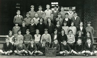
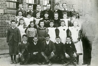
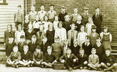
Photograph, Ringwood State School - Class photograph- Grade 6, 1933
Black and white photograph - Grade 6, 1933"Attached to photograph" Back Row - L to R: ?, ?, Ted Dufty, Dave Hill, ?, Jimmy Steer, 2nd Row -- L to R: Norm Bissett, Doug Jamieson, ?, ?, ?, Keith Norris, ?, ?. 3rd Row - L to R: ?, Doris Aird, Barbara Harris, Lilian Cope, Kath Jackson, Jean Ward, ?, Lucy Howship, Una (?), ?. 4th Row- L to R: Marjorie Clegg, ?, Doris Rutter, Jenny Rowe, ?, Rosemary Jenkins, ?, Joyce Muller, (?) Wheeler, Natalie Moulder. Front Row - L to R: ?, ?, John Anderson, ?, ?, Geoff Williams, ?, ?. Teacher: -
 Ringwood and District Historical Society
Photograph, Ringwood State School - Grade 4, 1923
Black and white photograph - Grade 4, 1923"Attached to photograph" Back Row - L to R: Betty McClelland, Thelma Wheeler, Gwen Thomas, Marie Squires, ?, Mildred Hill, Ida Wright, Diana Noble, ?, Thora Wilkins, Mary Pratt, ?. 2nd Row - L to R: Ruth Clark, Vera Reimers, Mary Stoel, Alice Cope, ?, Agnes Carpatus, Phyllis Allen, Jean Squires, Nancy Cook, Hazel Hams, Olive Brown, Marybelle McAlpine, ?. 3rd Row - L to R: ?, Bob Skerritt, Andrew Pratt, Walter Burnside, Joe Lobb, Frank Hayes, George Carmichael, Laurie Jones, Hugh Falconer, Henry Cope, (?) Burlock, George Howship, Ronald Hill, Ron Burns, Len Jones. Front Row - L to R: (?) Walters, Les Fitzell, Ken Astle, Bob Davies, Barry Martin, Merrick Northrope, Ralph Wigley, Les Paul, Albert Aird, Stan Saunders, Morry Deed. Teacher: -
 Ringwood and District Historical Society
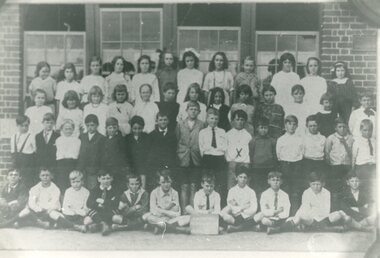
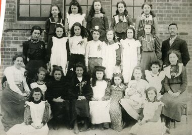
Photograph, Ringwood State School - Grade 6 (?), 1905
Black and white photograph - Grade 6(?), 1905"Attached to photograph" Back Row - L to R: Hilda Aird, Anastasia Smith, Clara Aird, Flo Blood, Edith Blood. 2nd Row - L to R: ?, Olive Porteous, Alice Blood, Evelyn Blood, Floss Hocking, Elvie Hill, ruby Saunders, Mr Hocking (Headmaster). 3rd Row - L to R: Miss Geraghty, Winnie Thomas, Vera Edgar, G McAlpin, Lena Williams, Alice Hodgetts, Ethel Colcott, Doris Oates, Miss Predeaux. Front Row - L to R: Mary Graham, Olive Burchett. Teacher: -
 Ringwood and District Historical Society
Photograph, Ringwood State School - Grade(?), 1901
Black and white photograph - Grade(?), 1901"Attached to photograph" Back Row - L to R: Mr Draper, Bert Hocking (Son of H.T.), George Tortice, Bill Knox, Fred Campbell, Alf Milne, Frank Parker 9( later Mayor of Ringwood), A Milne. 2nd Row - L to R: Edie Graham, Grace Thomas, Alice Hodgetts, ?, Ruby Saunders, Elvie Hill (Mrs McAlpin, Mayroress of Ringwood), ?. 3rd Row - L to R: ?, ?, ?, Vera Hunt, Floss Hocking (Daughter of H.T.), ?, Ethel Colcott, Winnie Thomas, Olive Porteous, Lena Williams. Front Row - L to R: (?) Wadeson, Violet McDermott, Anastasia Smith, Evlyn Blood, (?) Wadeson. Teacher: Mr Draper. -
 Ringwood and District Historical Society
Photograph, Ringwood State School - Grade(?), 1900
Black and white photograph - Grade(?), 1900"Attached to photograph" Back Row - L to R: Albert Brown, Charles Parker, ?, Andrew Grant, ?, (?) Parker. 2nd Row - L to R: ?, Edith Blood, Iris Thornley, ?, ?, C Hill. 3rd Row - L to R: (?) Blood, ?, Dora Parker, Alice Tortice, Clara Aird, Alice Smith, Maryann Blood. Front Row - L to R: Graham (?), S Oates, John Ryan, John Knox, ?, Horwood Falconer, Stanley Falconer. Teacher: Mr Hocking. -
 Ringwood and District Historical Society
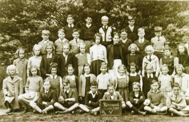
Photograph, Ringwood State School - Grade 5, 1947
Black and white photograph - Grade 5, 1947."Attached to photograph" Back Row - L to R: Graeme Rattray, Paul Divola, Brian Simpson, John Caird. 2nd Row - L to R: Norman Wright, Brian Pump, Russell Read, Bill France, Phillip Collins, Peter Wigley. 3rd Row - L to R: Nola Scurry, Lorres Hill, Valerie Gordon, Yvonne Goodwin, Linley Clark, Lois Stevenson, ?, ?, Jennifer Parker, Chris Patterson, ?. 4th Row - L to R: (?) Georgie, Evelyn Willis, ?, Marion Medhurst, ?, ?, Elain Mathews, Valerie Everett, Dawn McAlpine, ?, ?. Front Row - L to R: Noel Deed, Ron Frazer, Brian Mallet, Vernon Lee, Ted Polkinghorne, John Wigley, Keith Thompson. Teacher: Added Sc0024 photo to "Media" and deleted VC entry 2157 on 14th June 2022. Sc0024 now with this Entry. -
 Ringwood and District Historical Society
Photograph, Ringwood State School - Grade 3, 1945
Black and white photograph - Grade 3,1945."Attached to photograph" Back Row - L to R: ?, Brian Pump, Paul Divola, Stan McDonald, John Caird, Noel Deed, Peter Wigley, John Mathews. 2nd Row - L to R: Dawn McAlpine, ?, Marion Medhurst, ?, Julie Martin, Jennifer Parker, ?. 3rd Row - L to R: ?, ?, ?, Lrris Hill, ?, ?, ?, ?, ?, ?. 4th Row _ L to R: Bill France, Desmond Stewart, Russell Read, John Wigley, Norman Wright, ?, Ted Polkinghorne, Andrew Rothney, Les Bomford. Front Row - L to R: Bill Wright,, ?, Brian Mallett, Cliff Mead, Ray Hager, Vernon Lee, Jack Wakeham, Karl Martin. Teacher: Added Sc0021 photo to "Media" and deleted VC entry 2154 on 14th June 2022. Sc0021 now with this Entry. -
 Ringwood and District Historical Society
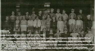
Photograph, Ringwood State School - Grade 2B,1956
Black and white photograph - Grade 2B, 1956."Attached to photograph" Back Row-L to R: Lester Coulthard, (?) Fitzgerald, Gary West, Graham Nicholls, Philip Male, Evan Patullock, David Simpson, Andrew Carter, Barry Carrington, Geoff Davis, Kenny Boyes. 2nd Row-L to R: Graham reid, Susan Schurmann, Helen Taylor, ?, ?, Lynette Bangay, Ruth Tozer, Helen Cannon, Kathleen Jackson, Denise Judd, Barbara Austin, Jennifer Whitford, Alison Clutterbuck. 3rd Row-L toR: Lynette Rodda, Margaret Kubiak, Carmen Powell, Anne Hill, Magdalena Padjasek, Glenda Bruce, Marilyn John, Sandra Martron, Fay McKenzie, Carol Regan, Susan Appleby, Christine McLennan. Front Row-L to R: John Semple, Andrew Radford, Pam Barber, Cheryl Pepper, Carol O'Reagan, Janet McLeod, Christine Brown, Rodney Rhinhardt, Grant Austin. Teacher: -
 Ringwood and District Historical Society
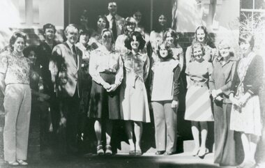
Photograph, Ringwood State School - Teachers, 1977
Black and white photograph - Teachers, 1977."Attached to photograph" L to R: Doreen, Joan Schofield (Special Migrant Teacher), Isobel Marshall, Baden Chadwick, Diane Barthing, Noelle Hill, Susan Morris, Mary Wedlar, Len Hadfield, Diane Chitty, Monica Harman, Mandy Thatcher, Anneli Symons, Sherry (?), Liz McCallum, Ailsa Dennis, Rosemary (?), Anne (?), Pam Greenwood. -
 Ringwood and District Historical Society
Photograph, Ringwood State School - Grade 4, 1976
Black and white photograph - Grade 4, 1976."Attached to photograph" Back Row- L to R: Gavin Williams, Sean Middlemast, Peter Noble, SHane Kerr, ?. 2nd Row- L to R: Anthony Dinicolantio, Philip Hagger, Robert McGregor, Greg Jenkinson, Eric Kanger, Mathew Caine, David Hill. 3rd Row- L to R: Jodie Shepherdson, Jill Baker, Cherie Moore, Karen Josht, Sharon Fraser, Janet Willers, Michelle Postlethwaite, Kelly Greenwood. Front Row- L to R: Fiona Murray, Julie Booth, Julie Walton, Debbie Hopgood, Linda Craig, Linda Rose, Karen Handreck, Michelle Brown, Margaret Kane. Front - Sitting : Paul Faye. Teacher: Mrs Webber. -
 Ringwood and District Historical Society
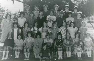
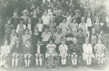
Photograph, Ringwood State School - Grade 3, 1975
Black and white photograph - Grade 3, 1975."Attached to photograph" Back Row- L to R: Shane Kerr, Gary (?), Peter Noble, David Hill, Shaun Middlemast, Anthony Dinkkuantonio, ?, Makk Faye. 2nd Row- L to R: Tracey Miller, Cheree Moore, Keryn (?), Paula (?), Andrea Rush, Deborah Hopgood, Linda Craig, Kelly Greenwood, Janet Willis. 3rd Row- L to R: Lisa Downey, Mathew Kane, ?, Robert McGregor, David Webb, Eric Kanga, Greg Smith, Karen Handreck. Front Row- L to R: Julie Booth, Jodie Meyer, Leanne Postlethwaite, Linda Rose, ?, Lesley Bonney, Louise Akins, Lisa Barnes, Margaret Kane. Teacher: Mrs Muscat -
 Ringwood and District Historical Society
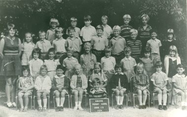
Photograph, Ringwood State School - Grade 2A, 1974
Black and white photograph - Grade 2A, 1974"Attached to photograph" Back Row- L to R: ?, ?, David Hill, ?, ?, ?. 2nd Row- L to R: No names 3rd Row- L to R: ?, Jodie (?), ?, ?, ?, Lesly Bonney, ?, ?. Front Row- L to R: No names Teacher: Mrs Murray -
 Ringwood and District Historical Society
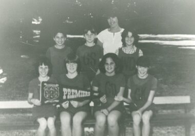
Photograph, Ringwood State School - Softball Team, 1982
Black and white photograph - Softball Team, 1982."Attached to photograph" Back Row- L to R: Michelle Berrigan, Michelle Wynne, Deborah Short, Stella Yiannaros. Front Row- L to R: Erica Gill, Trina Hill, Sharon Postlethwaite, Rachel Mavroudis, Katie Walton. Coach: Mrs Jones (Back row- middle). -
 Ringwood and District Historical Society
Photograph, Ringwood State School - Netball Team, 1982
Black and white photograph - Netball Team, 1982."Attached to photograph" Back Row- L to R: Erica Gill, Michelle Wynne, Michelle Berrigan. Front Row- L to R: Trina Hill, sharon Postlethwaite, Rachel Mavroudis, Katie Walton. Coach: Mrs Jones (Back row). -
 Ringwood and District Historical Society
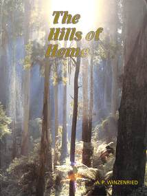
Book, Arthur Paul Winzenried, The Hills of Home - A.P. Winzenried, 1988
Soft covered book by Arthur Paul Winzenried. Full title: The Hills of Home - A Bicentennial History of the Shire of Sherbrooke (Victoria, Australia), including captioned colour and black & white photographs of the area.Cover - "Poems are made by fools like me, But only God can make a tree" - Joyce Kilmer. Photo Neil McLeod. Acknowledgements include thanks for members of the Sherbrooke Historical Society who gave their assistance which was particularly useful in the area of photographic materials. -
 Ringwood and District Historical Society
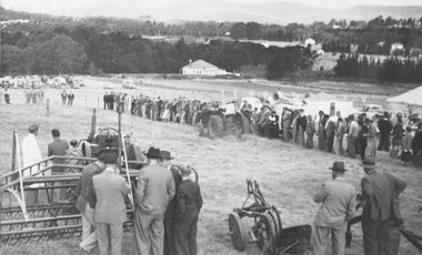
Photograph, Ford Industry Field Day - Loughnan's Hill, Ringwood - April, 1952
Black and white photographWritten on backing sheet- "Mail 10 April 1952. Ford Industry comes to Ringwood. Panoramic view of field day organised and arranged by Allan Coffey Motors showing tractors in operation slashing grass." Included with image- Copy of article in Ringwood Mail dated April 10, 1952,agriculture -
 Ringwood and District Historical Society
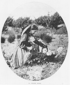
Photograph, Packing Flowers for Melbourne and Sydney at Mr. John Hill's Nursery, Ringwood
... , subdivided, name retained in street name. Miss. Elvie Hill. Black ...Black and white photograph (2 copies)Typed cutting on back of photograph: 'Australasian' 29/3/05. Later Howship's flower farm, subdivided, name retained in street name. Miss. Elvie Hill. -
 Ringwood and District Historical Society
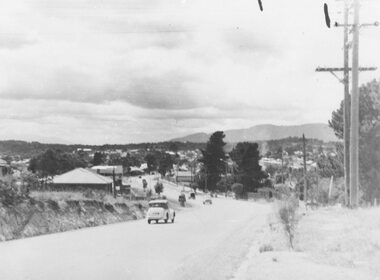
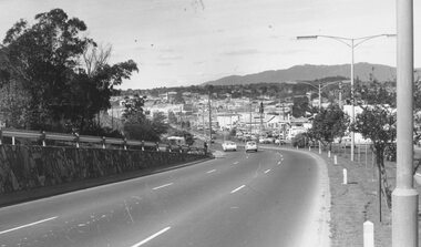
Photograph, Maroondah Highway West- Ringwood- c1949. Easterly view from Heatherdale Road along Whitehorse Road
Black and white photograph (2 large, 1 small)Written on back of photograph: "Main Street from Ringwood hill (near Heatherdale Road) c1949" -
 Ringwood and District Historical Society
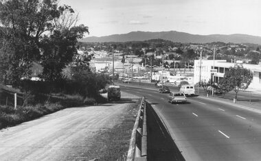
Photograph, Maroondah Highway West, Ringwood- 1974. Easterly view from Heatherdale Road
... from Ringwood Hill - 1974". Black and white photograph (2 ...Black and white photograph (2 copies)Written on backing sheet, "View from Ringwood Hill - 1974". -
 Ringwood and District Historical Society
Photograph, Maroondah Highway West, Ringwood- 1974. Easterly view from Heatherdale Road
... , "Descending Ringwood Hill into Ringwood - 1974". Black and white ...Black and white photographWritten on backing sheet, "Descending Ringwood Hill into Ringwood - 1974". -
 Ringwood and District Historical Society
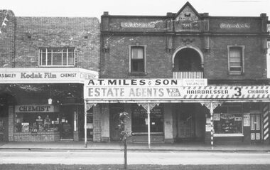
Photograph, Maroondah Highway Central, Ringwood. Coffee Palace and shops opposite Railway Station entrance- c1966
... to Coffee Palace, and Roy Hill's Hairdresser. Black and white ...Black and white photograph. (2 copies).Image shows shops including A.S. Bailey Chemist, A.T. Miles & Son Estate Agents, entrance to Coffee Palace, and Roy Hill's Hairdresser. -
 Ringwood and District Historical Society
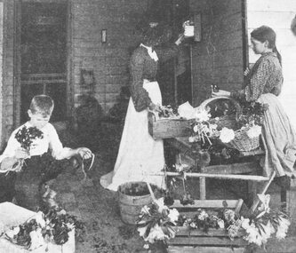
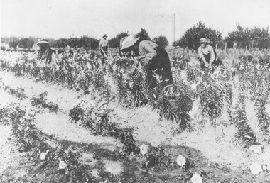
Photograph, Gathering Lancifolium Lilies and Queen Victoria Roses at Mr. John Hill's Nursery, Ringwood. 1905
Black and white photograph (2 copies)Typed under photograph: Gathering Lancifolium lillies and Queen Victoria roses at Mr John Hill's nursery, Ringwood. Typed below heading of one copy- "Mr. J. Hill's Nursery, Mt Dandenong Rd, Ringwood East. 1905. Written on back of photograph: "Hill Bros. Nursery 1905. (Mr. John Hill and daughters). Mt Dandenong Rd Ringwood East." Additional words- "Note Chimney stack (125' ?) from one of Ringwood brickworks on Dublin Rd. -
 Ringwood and District Historical Society
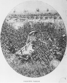
Photograph, Collecting Dahlias - Mr. Hill's Flower Farm - Mt. Dandenong Rd, Ringwood 1905
... name. Miss Elvie Hill. Black and white photograph (4 copies ...Black and white photograph (4 copies)Typed note at bottom of one photograph- "Mr. Hill's Flower Farm - Mt. Dandenong Rd. Miss Hill collecting dahlias. 1905." Typed note on back of separate photograph- "John Hill's flower farm 29/3/05, Mt Dandenong Rd, Ringwood East. Later Howship's flower farm, subdivided, name retained in street name. Miss Elvie Hill. -
 Ringwood and District Historical Society
Photograph, Collecting dahlias Hill Bros Flower Farm, Ringwood 1905
... , subdivided, name retained in street name. Miss Elvie Hill." Black ...Black and white photograph (2 copies)Written under one photograph- "Hill Bros Nursery, Mt Dandenong Rd, 1905. In 1912 sold to Howships. Written on back of one copy, " 'Australian' 29.3.05. John Hill's Flower Farm Mt. Dandenong Rd., later Howship's Flower Farm, subdivided, name retained in street name. Miss Elvie Hill."