Showing 5373 items
matching developing
-
 Ballarat Heritage Services
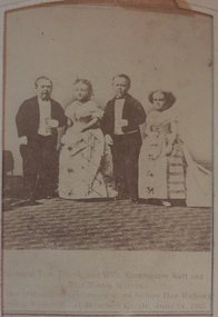
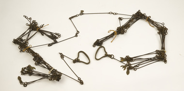
Photograph - Photograph - Black and White, Theatrical Troup, c1865
Tom Thumb and Lady were performers in P.T. Barnum’s circus. Once they became engaged, the public developed a fascination for them—nicknaming them the “little couple.” Barnum used their engagement to publicize his show, parading the couple around to different nations’ leaders and placing newspaper announcements detailing their upcoming wedding ceremony. On their wedding day in New York City, over 2,000 people entered the church to watch the couple say their vows. Fellow performers Minnie Warren (the bride’s younger sister) and “Commodore Nutt” (George Washington Morrison Nutt) served as the maid of honor and best man.Photographic tintype portrait of a child.General Tom Thumb and Wife, Commodore Nutt and Miss Minnie Warren, In the indentical costumes worn before Her Majesty Queen Victoria at Windsor Castle, June 1865.fullarton, tom thumb, theatre, commodore nutt, minnie warren, queen victoria -
 Moorabbin Air Museum
Machine - CAC CA-28 Ceres VH-WOT, 1962
Historical Details: he AARG aircraft is a composite restoration of 3 wrecks recovered from Airland Improvements at Cootamundra in 1974, including the remains of VH-WAX (CA-28-15) and VH-WHY (CA-28-17). The most substantially complete wreck was VH-WOT which as serial numbe. Description: Based on the CAC Wirraway trainer; the Ceres, named after the Roman Goddess of the Harvest was developed to meet the need of the aerial crop dusting industry for a purpose built agricultural aircraft. First flown in 1958 the Ceres could lift one ton of. Level of Importance: Nationalceres -
 Moorabbin Air Museum
Machine - CAC CA-28 Ceres (Cockpit)
Historical Details: he AARG aircraft is a composite restoration of 3 wrecks recovered from Airland Improvements at Cootamundra in 1974, including the remains of VH-WAX (CA-28-15) and VH-WHY (CA-28-17). The most substantially complete wreck was VH-WOT which as serial numbe. Description: Based on the CAC Wirraway trainer; the Ceres, named after the Roman Goddess of the Harvest was developed to meet the need of the aerial crop dusting industry for a purpose built agricultural aircraft. First flown in 1958 the Ceres could lift one ton of. Level of Importance: National -
 Kew Historical Society Inc
Album, Alick Kirkland Goulburn Gipps' Scrapbook, 1930s
Alick Gipps (1928-2014) was the son of Richard Brook Woodthorpe Gipps (1872-1946) and Mary Alys Kirkland (1889-1981), and the older brother of Christopher David Gipps (1930-52) and Rosemary Alison Gipps (1930-2013). While many scrapbooks of the period were created by, and or added to by their child owners, it is believed that "scrapbooks were considered by later Victorian parents to be an educational tool to teach children how to organise and classify information and to develop their ‘artistic’ senses" (Margaret Simpson, MAAS, 2008), and that the scrapbooks may have been compiled by the parent, rather than the child.The scrapbook is part of a large and significant collection of items donated by Rosemary Vaughan-Smith, past member and office-bearer of the Kew Historical Society. between 2005-12. The collection includes costumes, scrapbooks, autograph books, artworks and objects.Hard cover, 50-page album covered in red cloth and red leather corners and spine, the latter embossed with the words 'SCRAP BOOK' in gilt lettering. On the inside front cover, top left is an oval green label with retailer information - "WEDDING CHRISTENING / R. E. PENN. / Bible Warehouse / 213 REGENT St / BIRTHDAY PRESENTS". The paper used for the pages are in alternating blue, cream and green-coloured sections. The front pages of the scrapbook include the signature of the owner as Alick Kirkland [Goulburn] Gipps (1928-2014). Items pasted into the scrapbook include black and white and coloured illustrations, photographs, and extracts from books. Items selected for the scrapbook fill a single page or are arranged in groups. The oldest items in the scrapbook appear to date from 1859 and include a colour cover of the Illustrated London Almanack and pictorial handbills of electoral results for the seat of Holmesdale and Filmer in Kent, England. While other items in the book are of later periods, most can be classified as sentimental Victorian-era illustrations. The biblical scenes in the scrapbook reflect one aspect of the values of the Gipps family. The focus in the album on material about or published in Great Britain also suggests a preoccupation with, and a valuing of, traditional British culture. This is confirmed by the memberships of Alick and his sister Rosemary (Gipps) Vaughan-Smith in the English-Speaking Union Club, for which they welcomed guests at an 'Elizabethan party and barbecue' during the Coronation festivities of June 1953. (The Age, 3 June 1953, page 5). The album entered the collection of the Kew Historical Society as part of the Raymond and Rosemary (Gipps) Vaughan-Smith donation.manuscripts - kew historical society, rosemary vaughan-smith, vaughan-smith collection, alick kirkland goulburn gipps, scrapbooks - 20th century -
 Williamstown Botanic Gardens- Hobsons Bay City Council
Photos - Cannons, 1970
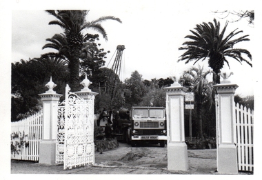
The Armstrong Cannons were originally placed at Fort Gellibrand, located at the southernmost tip of the Williamstown peninsula. The Fort was developed during the 1850s as part of a defensive system for the city and port of Melbourne. The importance of the Fort batteries declined from the 1890s, when they were effectively replaced by new facilities at Queenscliff and Point Nepean, but they were still used for gunnery practice. Local residents, through the Williamstown Town Council, complained to the Acting Minister for Defence that the concussion from the guns damaged windows, walls and foundations of buildings. The Armstrong Cannons were moved from Fort Gellibrand to the Gardens in 1906. A primary source of evidence of the cannons being in the Gardens. The cannons are remembered fondly as play equipment for the local children. Many tales have been told of climbing over them and pretending to be shot out of them A collection of seven black and white photographs documenting the removal of the cannons from the Gardens Photo 1 (a) Black and white landscape image. View is looking through the main gates looking at the front of the truck, which has the name Walter Wright across the front bumper, the crane and canon. The gates and fence are painted a light colour, probably white. Photo 2 (b) Black and white landscape image. Back of loader with cannon on it. Man standing on top of the cannon bending over either tying or untying ropes. Trunk of a palm tree is on the left side of the photo with a top of a palm tree in the background. Photo 3 (c) Black and portrait white image. A cannon being loaded by the crane on to trailer. Palm tree is in the background and fronds from a palm tree can be seen in the right top corner. Photo 4 (d) Black and white landscape image. Side on view of a cannon on the truck parked outside the grounds of the Gardens. The logo of the name of the trucking company is on the door of the truck above the words ‘WALTER H WRIGHT / TRANSPORT PTY LTD / S SCHULZ ST WEST MELB’. A second cannon can be seen in the background. A bus is in the background on the middle right side of the image. Photo 5 (e) Black and white landscape image. Truck with cannon on the back leaving the ground of the Gardens. Tree on the right side of the image and power pole is behind the truck. The logo of the name of the trucking company is on the door of the truck above the words ‘WALTER H WRIGHT / TRANSPORT PTY LTD / S SCHULZ ST WEST MELB’. ‘WALTER WRIGHT’ is on the front bumper Photo 6 (f) Black and white landscape image. Cannon tied down on the back of the truck as it is being driven across the street. Three houses in the background and two cars, one is a Volkswagen Photo 7 (g) Black and white landscape image. Cannon on the back of the truck which is parked over the street from the Gardens. Three houses are in the background. Two trees bare of leaves. The front of a car in in the foreground – it has a sun visor and the steering wheel is a light colour.armstrong cannons, williamstown botanic gardens, hobsons bay city council, 1970, walter h wright / transport pty ltd -
 Williamstown Botanic Gardens- Hobsons Bay City Council
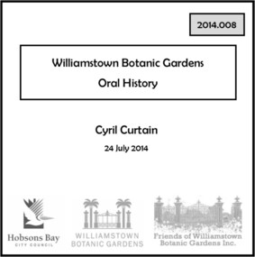
Oral History - Williamstown Botanic Gardens - Cyril Curtain, 24 July 2014
The interview is one of a series recorded in 2013-2014 to document memories and experiences of the Williamstown Botanic Gardens Cyril Curtain was born in Williamstown in 1928. He attended North Williamstown Primary School and Williamstown High School. Shortly after marrying he purchased a house on the Esplanade, where he still lives and in which this interview took place. Cyril’s work in conservation of the natural and built heritage is highly regarded. The recently developed Cyril Curtain Reserve in Williamstown is named in his honour. In this interview Cyril discusses the Gardens and the foreshore area including the beach and L A Parker Reserve A primary source of information on memories of the Gardens.CD and transcript of interview with Cyril Curtain and his memories of the Gardens and surrounding environs.fish pond, curator, cannons, williamstown botanic gardens, hobsons bay city council, aviary, pinetum, centennial reserve, midsummers night dream, cable tram car seats, infrared photography, , rotunda, gloucester reserve, 1934 storm, national trust, bateman house, clarke statue -
 National Wool Museum
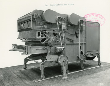
Photograph - Product Photograph, Automatic Feeding Machine
These are sales photographs for William Tatham Ltd. of Rochdale. These photographs are taken in the fitting shop at William Tatham Ltd. where final assembly would have taken place. The Automatic Feeding Machine automatically dispenses wool to a carding machine, so that an even, constant supply is received. This eliminated the manual labour previously needed for the initial weighing and feeding of wool. The photographed machine was made by William Tatham Ltd, a textile engineering company based in Rochdale, UK. Established in 1866, Tatham developed innovative textile machinery and sent their products to Australia and other countries around the world.Two black and white photos of an Automatic Feeding Machine in a landscape format. The first photo is of the front of the machine, the second is of the rear.8037.1 - Front - top margin: For description see over. Front mide right edge - Wm. TATHAM Ltd. ROCHDALE. Machine Maker Front bottom right corner - 1146 Rear - 78” wide Automatic Feeding Machine having Dual Hoppers in which the first and large section feeds the second Hopper so as to maintain a constant level of material in the latter. The driving of both spiked lattices is by electro-magnetic clutches, the one in the first Hopper being actuated by a sensitive feeler motion in the second, the second spiked lattice however, being controlled, of course, from the Scale Pan. Through a mercury switch. The scale is of our latest super-sensitive pattern mounted diagonally across the Feed. Only the opening doors are used in the actual weighting and the trap doors placed over the scale which close immediately the correct weight is deposited, operate through a solenoid. The machine incorporates many other features and is arranged to divide for facility in cleaning. 8037.2 - Front mide right edge - Wm. TATHAM Ltd. ROCHDALE. Machine Maker Front bottom right corner - 1147 Rear - Showing opposite side of Dual Automatic Feed illustrated in photo 1146textile machinery, automatic feeding machine, tatham, feeding machine -
 Vision Australia
Administrative record - Text, Royal Victorian Institute for the Blind annual report 1980-1981, 1980-1981
Articles in annual report include: the development of an educational camp at Romsey through the bequest of Mrs Cecelia Tye, a new Family Group home at Andrews Street, East Burwood, new program developed for Trans Australia Airlines providing mobility instruction to air hostesses when guiding blind passengers, three kiosks at RMIT, Melbourne University and RVIB providing employment and training for blind workers, a short term contract assembling motorcycles, introduction of paperless Brailler (Digicasette), beginning of Il Globo becoming available as an audio magazine and provision of up to $3000 interest home loan for blind people. 1 volume of printed materialroyal victorian institute for the blind, corporation records -
 Vision Australia
Badge - Object, Daisy consortium anniversary badge, 2011
The DAISY consortium was established in 1996 to develop an industry standard for the emerging digital book market. It's partners recognised that by incorporating the same features when constructing digital recordings with text, and using an established structure, publications could be usefully exchanged and sent around the world. In 2011 the consortium celebrated it's 15th anniversary and commemoration badges were sent to it's members, which included NILS (the production and library divisions of the Royal Blind Society of NSW, Vision Australia Foundation and RVIB). The badge has a blue swirl above and below the words 'daisy consortium' with '15th anniversary' at the base.Small badge with black writing on white backgrounddaisy consortium 15th anniverary badges, national information library service -
 Falls Creek Historical Society
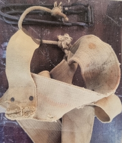
Equipment - Belt and Nutcracker, 1951
The first nutcracker tow at Falls Creek was the Nissen Tow operated by Toni and Skippy St. Elmo. It had a capacity of five people at one time and cost 6/- day in 1951. The tow was powered by a Buick engine and operated from 1951 until 1960. Other nutcracker tows at Falls Creek were the Village (left side), Village (right side) and the Dog Patch Tow, By the 1960s nutcracker tows were rapidly being replaced in the developing major resorts although a few rope tows remained in use largely to assist access over areas of fairly flat terrain.This item is significant because it came from the original Rope Tow, Nissen, at Falls Creek, VictoriaThe nutcracker (metal clamp) has two handles that clamp onto the rope when closed together. The clamping part of the nutcracker is at the end near the hinge. The nutcracker is attached to a belt via a short rope, and a small metal loop is attached to the belt, onto which the nutcracker can be stored whilst skiing. When riding the nutcracker, the rope attachment is worn to the front which can then be pushed around to the side whilst skiing. The belt needs to be worn tightly around the hips.falls creek tows, nissen tow, toni and skippy st. elmo -
 Wodonga & District Historical Society Inc
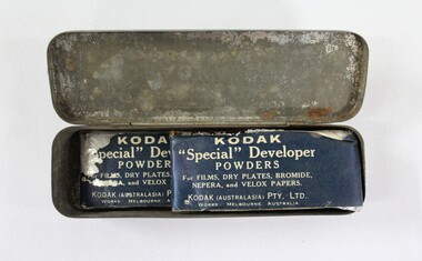
Functional object - Kodak Photographic Powder stored inside Alloy Tin, Kodak, c. late 1800s - early 1900s
The Kodak powders inside this tin were used in the production of dry plate photography. Dry plate photography was a photographic technology invented by R.L. Maddox in 1871. Images were captured on a glass plate covered in a gelatin emulsion, which acted as a photographic negative. A negative could then be stored to develop at a later time in a dark room. The introduction of this technology allowed for greater flexibility in photographic practice outside of indoor studios, as earlier wet plate photographic technology required immediate exposure and development. Dry plate photography was superseded by the invention of celluloid film in the early twentieth century.This item forms part of a significant and representative historical collection which reflects the local history of Wodonga. It contributes to our understanding of social life in early twentieth century Wodonga, as well as providing interpretative capacity for themes including local history, social history, and the history of photography.A silver toned alloy tin with hinged lid. Inside are two packets of Kodak brand dry plate developer powder. On face of tin lid "20 BELLMETAL REEDS/B.C DUNLOP SYSTEM/CRACKAJACK/HAND FITTED AND TURNED/MADE IN (SENIOR) GERMANY"photography, wet plate photography, dry plate photography, photos, haeusler collection, history of photography, historical photographs, technology, wodonga -
 Melbourne Legacy
Document, Business Leadership: first Luncheon Address delivered to Legacy Club (H45), 1923
An address delivered by P.W. Powell (the first Secretary of the Club) in October 1923 to the newly formed Legacy Club. In it he notes that "The most important thing in the development of this Club is to formulate a sound constructive policy that will draw in the best type of member and make the Club a live force in the advancement of this country." The comradeship and cooperation developed by the troops during wartime should be applied in civilian life to the development of Australia. He finishes by calling for the Club to be named the Legacy Club "in token of the heritage that has been bequeathed to us by those who so nobly commended the work that is left to us to carry on."An insight into corporate and political thinking of the 1920s as the country transitioned from wartime to peacetime, and an insight into the thinking of one of the founder members of Melbourne Legacy.4 sheets of white copy paper, black typing.'H45' (see Item 00937)in blue ink on first pagehistory, founding legatee -
 Forests Commission Retired Personnel Association (FCRPA)
Gunter's Chain
Before metrication was introduced into Australia in the 1970s land was measured in chains and links. Many old parish plans show length measurements in chains and links. Area was shown in acres, roods and perches. Gunter's chain was used for measuring distance in surveying. It was designed and introduced in 1620 by English clergyman and mathematician Edmund Gunter (1581–1626). Gunter developed the measuring chain of 100 links. The chain and the link, became statutory measures in England and subsequently the British Empire. After metrication units of length were measured in meters and area in hectares. The chain was later superseded by steel ribbon tape.The 66 foot long brass Gunter's Chain is divided into 100 links (each 7.92 inches long), and marked off into groups of 10 by shaped tags which simplify intermediate measurement. It was heavy but flexible enough to be dragged through the bush on surveying transects.(Hence the common forestry term "chainman). The chain was a precision part of a surveyor's equipment. It required frequent calibration, yet needed to be sturdy enough to be dragged through rough terrain for years. It has brass hand grips at each end of chain. 1 chain = 100 links = 22 yards = 66 feet = 792 inches. 10 chains = furlong 80 chains = 1 mile 1 acre = 10 square chains = 4 roods (1/4 acre) = 40 perches.forest measurement, surveying, forests commission victoria (fcv) -
 Wangaratta RSL Sub Branch
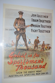
Poster, Enlist in the Sportsmen's Thousand, 1917
This poster, published by the State Parliamentary Recruiting Committee, depicts Lieutenant Albert JACKA, VC, as a role model for a huge campaign to enlist sportsmen into the Australian Imperial Force in 1917. Jacka achieved instant fame back home when he became the first Australian to win the Victoria Cross during the First World War. It was said that one of the reasons he was such a good soldier, and had such a fighting attitude, was that he had been a boxer before the war. The campaign to enlist sportsmen was fuelled by a strong belief that by playing sport young men developed specific skills and qualities that could be used on the battlefield.Representative of two common recruiting devices used in Australia, a well-known local soldier and a target number of men required for a specially named group.Depicts Lieutenant Albert Jacka, VC, as a role model for a huge campaign to enlist sportsmen. Surrounding Jacka are colourful depictions of healthy young men engaged in a variety of sports: football, rowing, cricket, tennis and golf are amongst the sports.Full Text: Enlist in the Sportsmen's Thousand, Join Together, Train Together, Embark Together, Fight Together, Show the enemy what Australian sporting men can do.albert jacka, ww1, poster -
 Eltham District Historical Society Inc
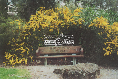
Postcard, Take a seat in history, Alistair Knox Park, Eltham; Celebrating Children's Week 2000, 2000
Postcard as part of a series produced by Shire of Nillumbik for a children's photo project "Nillumbik Naturally" developed by FOCUS FORCE cleebrating Children's Week 2000. Words and photo by Janelle Chambers (Age 13). The logo for the Nillumbik Tourism Assocation Inc is stamped on the front of the postcard. This seat was placed in Alistair Knox Park in commemoration of the end of the Shire of Eltham after Victorian Council amalgamations with the words "Shire of Eltham 1871-1994" included on the back wooden plate of the seat. A similiar seat was placed in the Montmorency Shopping Centre referencing the west riding of the Eltham Shire, which incuded Montmorency. Digital file only - Digitised by EDHS from a scrapbook on loan from Beryl Bradbury (nee Stokes), daughter of Frank Stokes. Also physical postcard (used) alistair knox park, beryl bradbury (nee stokes) collection, janelle chambers, nillumbik tourism association, wattle, seat, children's week, commemoration -
 Orbost & District Historical Society
black and white photograph, C1910
the Orbost State School opened on19th of March 1886. The school had first operated temporarily in a leased building, and on a half-time basis with SS2745 Jarrahmond, The head teacher was Campbell Mackay who remained in charge only until 12th of May 1886. The second head teacher, John Rowe, served until 1908. On 30th of June 1887, a portable room was provided; it being brought to the area by schooner. The school now had accommodation for 30 pupils; the teacher's welfare was considered because quarters of two rooms were attached. As the population increased so did the needs of the school. This was reflected in the provision of a larger classroom in 1898. During 1910-11 the first approaches were made to the Department for the establishment of a Higher Elementary School in Orbost and this became a reality in 1912. Orbost. The Higher Elementary School supplied post-primary education in the district until a high school was built in 1948. When fire destroyed the school in 1941 local halls were used as classrooms until a new school was built, opened by the Hon. A. E. Lind, MLA, on 13th of February 1942. But Orbost continued to develop and the new school was soon overtaxed. This resulted in the erection of two Bristol classrooms in 1947. By 1950, when the school population had reached 500 pupils the opening of the new school at Orbost North was welcomed by all concerned. In 1963 the Department purchased land diagonally opposite the school and developed it as a playing area.This item is associated with education in the Orbost district.A black / white photograph of a large school building with two men standing out the front.orbost-state-school education-orbost -
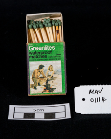 City of Moorabbin Historical Society (Operating the Box Cottage Museum)
Maufactured Objects, 1 box of Bryant & May waterproof safety matches, 20thC
‘Strike anywhere’ or ‘Waterproof’ matches are still used today all around the world, including many developing countries and are widely used for camping, outdoor activities, emergency/survival /military situations, and stocking homemade survival kits. Anton Schrötter von Kristelli discovered in 1850 that heating white phosphorus at 250 °C in an inert atmosphere produced a red allotropic form, which did not fume in contact with air. It was suggested that this would make a suitable substitute in match manufacture although it was slightly more expensive. Two French chemists, Henri Savene and Emile David Cahen, proved in 1898 that the addition of phosphorus sesquisulfide meant that the substance was not poisonous, that it could be used in a "strike-anywhere" match, and that the match heads were not explosive. British company Albright and Wilson, was the first company to produce phosphorus sesquisulfide matches commercially. The company developed a safe means of making commercial quantities of phosphorus sesquisulfide in 1899 and started selling it to match manufacturers. Bryant and May was a United Kingdom (UK) company created in the mid-nineteenth century specifically to make matches. Their original Bryant and May Factory was located in Bow, London. They later opened other match factories in the United Kingdom and Australia. On 15th December 1909, Bryant & May, Australia’s first match factory at Church Street, Richmond, Victoria. was opened by The Honorable Alfred Deakin, Prime Minister of Australia, and Mrs. Deakin The Bryant & May Ltd factory in Church St Richmond is a listed building and has been converted to apartments following the closure of the Company 1980. Bryant & May's Ltd were influential in fighting against the dreadful disease known as Phossy jaw which was caused by white phosphorus used in the manufacture of the early matches. They were also the object of the 'Match Girls Strike' in London 1888, which won important improvements in working conditions and pay for the mostly female workforce working with the dangerous white phosphorus. The public were slow to purchase these red phosphorus sesquisulfide safety matches because of the higher price1 box of unused Bryant & May safety matches 'Greenlite' waterproof Greenlites / waterproof / matches / CONTENTS 47 / MADE IN AUSTRALIA BY BRYANT & MAY / E 2994 photograph of a man and woman beside a camp fire on the beachsafety matches, bryant & may pty ltd, phossy jaw disease, early settlers, moorabbin, bentleigh, cheltenham, lights, lamps, tobacco, white phosphorous, red, phosphorus sesquisulfide, swedish match pty ltd, pitt william, savens henri, cahen emile david , richmond victoria, -
 Eltham District Historical Society Inc
Document, 14 Stokes Place, Eltham: Building plans and contracts, 1979c
14 Stokes Place was the home of Peter and Carla Vermey. The land was purchased in May 1979 and the home built by Peter and Carla Vermey after the developer, Macquarie Builders went bankrupt. Sold October 2017 by Morrison and Kleeman Real Estate. Stokes Place was part of the Stokes Orchard Estate which was developed from the break-up of the the orchard owned by Frank Stokes who lived on the northeast corner of Nyora Road and Eucalyptus Road. His daughter Beryl advised that the Shire had levied a rate assessment on individual parcels of land within the orchard which became unaffordable resulting in its sub-division and sell off. The Stokes Orchard Estate was developed by Macquarie Builders in two stages starting with stage 1 in 1976. Stokes Place was part of Stage 2 in 1979. The Estate was bounded between Nyora Road, Eucalyptus Road, Diosma Road and Stokes Place. The original orchard only just reached the left most portions of Stokes Place and did not go fully up to Diosma, rather to just beyond the extant of Stokes Place. Stokes Place was known within the family as "The Oats" as that is where they grew oats. Frank Stokes moved to Eltham c.1945 after visiting Harold Bird to view his orchard, located diagonally opposite Stokes Orchard from the intersection of Eucalyptus Road, Pitt Street and Nyora Road. It was on Harold Bird's recommendation that Frank purchased the land.The Stokes Orchard Estate collection is typical of housing developments of the late 1970s and 1980s. It was one of the earliest estates in Eltham following the nearby Woodridge Estate development.Digital file30 digital files scanned from documents provided on loan by Peter and Carla Vermeystokes place, eltham, stokes orchard, stokes orchard estate, streets, houses, peter and carla vermey -
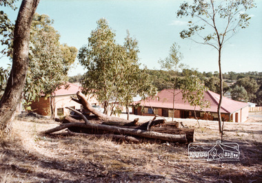
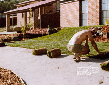
 Eltham District Historical Society Inc
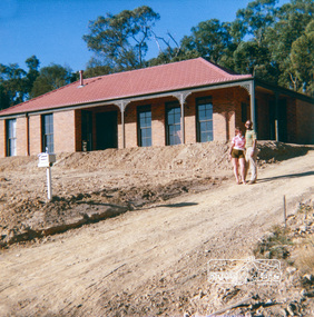
Photograph, 14 Stokes Place, Eltham, April 1980, 1980
14 Stokes Place was the home of Peter and Carla Vermey. The land was purchased in May 1979 and the home built by Peter and Carla Vermey after the developer, Macquarie Builders went bankrupt. Sold October 2017 by Morrison and Kleeman Real Estate. Stokes Place was part of the Stokes Orchard Estate which was developed from the break-up of the the orchard owned by Frank Stokes who lived on the northeast corner of Nyora Road and Eucalyptus Road. His daughter Beryl advised that the Shire had levied a rate assessment on individual parcels of land within the orchard which became unaffordable resulting in its sub-division and sell off. The Stokes Orchard Estate was developed by Macquarie Builders in two stages starting with stage 1 in 1976. Stokes Place was part of Stage 2 in 1979. The Estate was bounded between Nyora Road, Eucalyptus Road, Diosma Road and Stokes Place. The original orchard only just reached the left most portions of Stokes Place and did not go fully up to Diosma, rather to just beyond the extant of Stokes Place. Stokes Place was known within the family as "The Oats" as that is where they grew oats. Frank Stokes moved to Eltham c.1945 after visiting Harold Bird to view his orchard, located diagonally opposite Stokes Orchard from the intersection of Eucalyptus Road, Pitt Street and Nyora Road. It was on Harold Bird's recommendation that Frank purchased the land.The Stokes Orchard Estate collection is typical of housing developments of the late 1970s and 1980s. It was one of the earliest estates in Eltham following the nearby Woodridge Estate development.Digital fileScanned from a print contained in owner's photo album (81 prints in total digitised)stokes place, eltham, stokes orchard, stokes orchard estate, streets, houses, peter and carla vermey -
 Eltham District Historical Society Inc
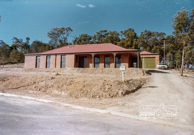
Photograph, 14 Stokes Place, Eltham, April 1980, 1980
14 Stokes Place was the home of Peter and Carla Vermey. The land was purchased in May 1979 and the home built by Peter and Carla Vermey after the developer, Macquarie Builders went bankrupt. Sold October 2017 by Morrison and Kleeman Real Estate. Stokes Place was part of the Stokes Orchard Estate which was developed from the break-up of the the orchard owned by Frank Stokes who lived on the northeast corner of Nyora Road and Eucalyptus Road. His daughter Beryl advised that the Shire had levied a rate assessment on individual parcels of land within the orchard which became unaffordable resulting in its sub-division and sell off. The Stokes Orchard Estate was developed by Macquarie Builders in two stages starting with stage 1 in 1976. Stokes Place was part of Stage 2 in 1979. The Estate was bounded between Nyora Road, Eucalyptus Road, Diosma Road and Stokes Place. The original orchard only just reached the left most portions of Stokes Place and did not go fully up to Diosma, rather to just beyond the extant of Stokes Place. Stokes Place was known within the family as "The Oats" as that is where they grew oats. Frank Stokes moved to Eltham c.1945 after visiting Harold Bird to view his orchard, located diagonally opposite Stokes Orchard from the intersection of Eucalyptus Road, Pitt Street and Nyora Road. It was on Harold Bird's recommendation that Frank purchased the land.The Stokes Orchard Estate collection is typical of housing developments of the late 1970s and 1980s. It was one of the earliest estates in Eltham following the nearby Woodridge Estate development.Digital fileScanned from a print contained in owner's photo album (81 prints in total digitised)stokes place, eltham, stokes orchard, stokes orchard estate, streets, houses, peter and carla vermey -
 Eltham District Historical Society Inc
Photograph, 14 Stokes Place, Eltham, April 1980, 1980
14 Stokes Place was the home of Peter and Carla Vermey. The land was purchased in May 1979 and the home built by Peter and Carla Vermey after the developer, Macquarie Builders went bankrupt. Sold October 2017 by Morrison and Kleeman Real Estate. Stokes Place was part of the Stokes Orchard Estate which was developed from the break-up of the the orchard owned by Frank Stokes who lived on the northeast corner of Nyora Road and Eucalyptus Road. His daughter Beryl advised that the Shire had levied a rate assessment on individual parcels of land within the orchard which became unaffordable resulting in its sub-division and sell off. The Stokes Orchard Estate was developed by Macquarie Builders in two stages starting with stage 1 in 1976. Stokes Place was part of Stage 2 in 1979. The Estate was bounded between Nyora Road, Eucalyptus Road, Diosma Road and Stokes Place. The original orchard only just reached the left most portions of Stokes Place and did not go fully up to Diosma, rather to just beyond the extant of Stokes Place. Stokes Place was known within the family as "The Oats" as that is where they grew oats. Frank Stokes moved to Eltham c.1945 after visiting Harold Bird to view his orchard, located diagonally opposite Stokes Orchard from the intersection of Eucalyptus Road, Pitt Street and Nyora Road. It was on Harold Bird's recommendation that Frank purchased the land.The Stokes Orchard Estate collection is typical of housing developments of the late 1970s and 1980s. It was one of the earliest estates in Eltham following the nearby Woodridge Estate development.Digital fileScanned from a print contained in owner's photo album (81 prints in total digitised)stokes place, eltham, stokes orchard, stokes orchard estate, streets, houses, peter and carla vermey -
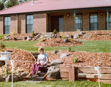
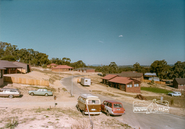 Eltham District Historical Society Inc
Photograph, Stokes Place, Eltham, April 1980; viewed from near no. 10 looking southeast, 1980
14 Stokes Place was the home of Peter and Carla Vermey. The land was purchased in May 1979 and the home built by Peter and Carla Vermey after the developer, Macquarie Builders went bankrupt. Sold October 2017 by Morrison and Kleeman Real Estate. Stokes Place was part of the Stokes Orchard Estate which was developed from the break-up of the the orchard owned by Frank Stokes who lived on the northeast corner of Nyora Road and Eucalyptus Road. His daughter Beryl advised that the Shire had levied a rate assessment on individual parcels of land within the orchard which became unaffordable resulting in its sub-division and sell off. The Stokes Orchard Estate was developed by Macquarie Builders in two stages starting with stage 1 in 1976. Stokes Place was part of Stage 2 in 1979. The Estate was bounded between Nyora Road, Eucalyptus Road, Diosma Road and Stokes Place. The original orchard only just reached the left most portions of Stokes Place and did not go fully up to Diosma, rather to just beyond the extant of Stokes Place. Stokes Place was known within the family as "The Oats" as that is where they grew oats. Frank Stokes moved to Eltham c.1945 after visiting Harold Bird to view his orchard, located diagonally opposite Stokes Orchard from the intersection of Eucalyptus Road, Pitt Street and Nyora Road. It was on Harold Bird's recommendation that Frank purchased the land.The Stokes Orchard Estate collection is typical of housing developments of the late 1970s and 1980s. It was one of the earliest estates in Eltham following the nearby Woodridge Estate development.Digital fileScanned from a print contained in owner's photo album (81 prints in total digitised)stokes place, eltham, stokes orchard, stokes orchard estate, streets, houses, peter and carla vermey -
 Eltham District Historical Society Inc
Photograph, 14 Stokes Place, Eltham, April 1980, 1980
14 Stokes Place was the home of Peter and Carla Vermey. The land was purchased in May 1979 and the home built by Peter and Carla Vermey after the developer, Macquarie Builders went bankrupt. Sold October 2017 by Morrison and Kleeman Real Estate. Stokes Place was part of the Stokes Orchard Estate which was developed from the break-up of the the orchard owned by Frank Stokes who lived on the northeast corner of Nyora Road and Eucalyptus Road. His daughter Beryl advised that the Shire had levied a rate assessment on individual parcels of land within the orchard which became unaffordable resulting in its sub-division and sell off. The Stokes Orchard Estate was developed by Macquarie Builders in two stages starting with stage 1 in 1976. Stokes Place was part of Stage 2 in 1979. The Estate was bounded between Nyora Road, Eucalyptus Road, Diosma Road and Stokes Place. The original orchard only just reached the left most portions of Stokes Place and did not go fully up to Diosma, rather to just beyond the extant of Stokes Place. Stokes Place was known within the family as "The Oats" as that is where they grew oats. Frank Stokes moved to Eltham c.1945 after visiting Harold Bird to view his orchard, located diagonally opposite Stokes Orchard from the intersection of Eucalyptus Road, Pitt Street and Nyora Road. It was on Harold Bird's recommendation that Frank purchased the land.The Stokes Orchard Estate collection is typical of housing developments of the late 1970s and 1980s. It was one of the earliest estates in Eltham following the nearby Woodridge Estate development.Digital fileScanned from a print contained in owner's photo album (81 prints in total digitised)stokes place, eltham, stokes orchard, stokes orchard estate, streets, houses, peter and carla vermey -
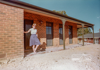
 Eltham District Historical Society Inc
Photograph, 14 Stokes Place, Eltham, April 1980, 1980
14 Stokes Place was the home of Peter and Carla Vermey. The land was purchased in May 1979 and the home built by Peter and Carla Vermey after the developer, Macquarie Builders went bankrupt. Sold October 2017 by Morrison and Kleeman Real Estate. Stokes Place was part of the Stokes Orchard Estate which was developed from the break-up of the the orchard owned by Frank Stokes who lived on the northeast corner of Nyora Road and Eucalyptus Road. His daughter Beryl advised that the Shire had levied a rate assessment on individual parcels of land within the orchard which became unaffordable resulting in its sub-division and sell off. The Stokes Orchard Estate was developed by Macquarie Builders in two stages starting with stage 1 in 1976. Stokes Place was part of Stage 2 in 1979. The Estate was bounded between Nyora Road, Eucalyptus Road, Diosma Road and Stokes Place. The original orchard only just reached the left most portions of Stokes Place and did not go fully up to Diosma, rather to just beyond the extant of Stokes Place. Stokes Place was known within the family as "The Oats" as that is where they grew oats. Frank Stokes moved to Eltham c.1945 after visiting Harold Bird to view his orchard, located diagonally opposite Stokes Orchard from the intersection of Eucalyptus Road, Pitt Street and Nyora Road. It was on Harold Bird's recommendation that Frank purchased the land.The Stokes Orchard Estate collection is typical of housing developments of the late 1970s and 1980s. It was one of the earliest estates in Eltham following the nearby Woodridge Estate development.Digital fileScanned from a print contained in owner's photo album (81 prints in total digitised)stokes place, eltham, stokes orchard, stokes orchard estate, streets, houses, peter and carla vermey -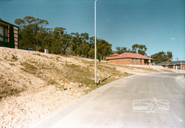
 Eltham District Historical Society Inc
Photograph, 14 Stokes Place, Eltham, April 1980, 1980
14 Stokes Place was the home of Peter and Carla Vermey. The land was purchased in May 1979 and the home built by Peter and Carla Vermey after the developer, Macquarie Builders went bankrupt. Sold October 2017 by Morrison and Kleeman Real Estate. Stokes Place was part of the Stokes Orchard Estate which was developed from the break-up of the the orchard owned by Frank Stokes who lived on the northeast corner of Nyora Road and Eucalyptus Road. His daughter Beryl advised that the Shire had levied a rate assessment on individual parcels of land within the orchard which became unaffordable resulting in its sub-division and sell off. The Stokes Orchard Estate was developed by Macquarie Builders in two stages starting with stage 1 in 1976. Stokes Place was part of Stage 2 in 1979. The Estate was bounded between Nyora Road, Eucalyptus Road, Diosma Road and Stokes Place. The original orchard only just reached the left most portions of Stokes Place and did not go fully up to Diosma, rather to just beyond the extant of Stokes Place. Stokes Place was known within the family as "The Oats" as that is where they grew oats. Frank Stokes moved to Eltham c.1945 after visiting Harold Bird to view his orchard, located diagonally opposite Stokes Orchard from the intersection of Eucalyptus Road, Pitt Street and Nyora Road. It was on Harold Bird's recommendation that Frank purchased the land.The Stokes Orchard Estate collection is typical of housing developments of the late 1970s and 1980s. It was one of the earliest estates in Eltham following the nearby Woodridge Estate development.Digital fileScanned from a print contained in owner's photo album (81 prints in total digitised)stokes place, eltham, stokes orchard, stokes orchard estate, streets, houses, peter and carla vermey