Showing 24380 items
matching matthew-creek
-
 Stawell Historical Society Inc
Photograph, Pleasant Creek Court House with Stawell Histotical Society member Betty Collins seated with Stawell Historical Society Past President Margaret Mason satnding
Interior main hall of Pleasant Creek Court House. Stawell Historical Society member Betty Collins seated and Past President Margaret Mason standing with banner. stawell -
 Stawell Historical Society Inc
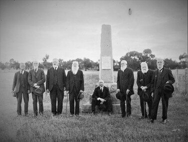
Photograph, "Peace" Memorial on Halls Gap Road built 1919 at site of old Treasury Building Commercial Street Pleasant Creek c1922
Group of Gentlemen beside the Peace Memorial situated on Halls Gap Road built 1919 at site of old Treasury Building Commercial Street Pleasant Creek. C1922stawell -
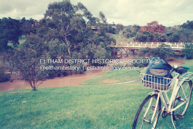
 Eltham District Historical Society Inc
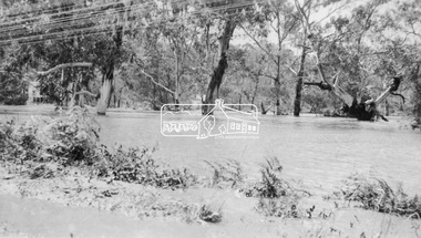
Negative - Photograph, Floodwaters, Diamond Creek, Eltham, 1934
The Diamond Creek in flood near the Main Road bridge at Eltham, Victoria. The Yarra also was in flood. In early December 1934 the "Greatest flood in the history of the Yarra" occured, according to The Argus newspaper. Bridges and houses were swept away with hundreds of people left homeless across the state. The historic 1934 flood of the Diamond Creek and Yarra River set the criteria for future planning with respect to flood water rise. Noted on reverse of print - Copied by Hugh Fisher, 82 Lygon St., BrunswickThis photo forms part of a collection of photographs gathered by the Shire of Eltham for their centenary project book,"Pioneers and Painters: 100 years of the Shire of Eltham" by Alan Marshall (1971). The collection of over 500 images is held in partnership between Eltham District Historical Society and Yarra Plenty Regional Library (Eltham Library) and is now formally known as the 'The Shire of Eltham Pioneers Photograph Collection.' It is significant in being the first community sourced collection representing the places and people of the Shire's first one hundred years.Digital image 4 x 5 inch B&W Neg (2 frames on one neg) Print 9 x 15.5 cmOn reverse of print - "Copied by Hugh Fisher, 82 Lygon St., Brunswick" (for Shire of Eltham)sepp, shire of eltham pioneers photograph collection, eltham, floods, 1934 flood, diamond creek (creek), floodwater -
 Falls Creek Historical Society
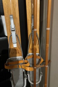
Equipment - Skis from the Four Seasons Lodge, Falls Creek
In 1948 Bob Hymans (1922-2007) built a small lodge on the corner of Falls Creek Road by the oversnow called Four Seasons or The Grand Coeur Annexe. Believed to be a wonderful host Bob also owned and operated Southern Cross and Grand Coeur. Grand Coeur unfortunately burnt down in 1961. These skis, now located in the Falls Creek Museum, were donated by Bob’s daughter Bridget. They hung in the main room of the Lodge for many years, never touching snow.These skis are significant because they were owned by Bob Hymans, a pioneer of Falls Creek, Victoria.A pair of wooden skis with bindings and poles.bob hymans, four seasons, grand coeur chalet -
 Eltham District Historical Society Inc
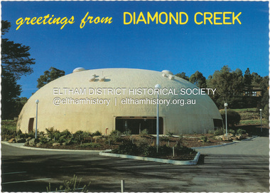
Postcard - Photograph, Nucolorvue Productions Pty Ltd, greetings from Diamond Creek, n.d
Diamond Creek Bini Shell Community venue Built in 1979 in Diamond Creek opposite the hotel using a construction method invented by Dante Bini. A net of flexible steel rods were laid on the building’s circular base, on the top of a fabric bladder. Concrete was poured onto the mesh and a sealed cover laid over the concrete making a sandwich of cover, bladder and mesh. Compressed air was pumped into the bladder and the sandwich slowly began to rise and become a massive self-supporting dome. The inflation of the dome attracted crowds of onlookers many from various technical schools, VIPs and the famous football doctor, Donald Cordner. An opening night dinner was held to celebrate the construction and the Diamond Creek Bini Shell was used as a community venue for over ten years including for the Town Fair. The Shell was closed for safety reasons after a Bini Shell in another State had chunks of concrete fall off the dome due to a construction fault. At the Diamond Creek Town Fair in 1991 the demolition of the Bini Shell was an item on the Town Fair’s program. Information: Kevin Patterson, Nillumbik Historical Societybini shell, diamond creek community centre, nu-color-vue, postcard -
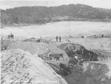 El Dorado Museum Association Inc.
Photograph (item) - Digital Image
Altering course of Reedy Creek, El Dorado. Cocks Pioneer Electric Gold & Tin Mine Company was formed in 1899. The company's first power station, located at the eastern end of the valley began operating with its 340 Kilowatt steam-powered generator. By 1909, from 2,500,000 cubic yards worked, reported recovery was 17,284 ounces of gold and 224 tons of tin ore. By 1909, Cocks Pioneer’s power plant had become inadequate and uneconomical. The barge was floated downstream about a mile, but lost time caused the operations to cease. Following testing, a new mine was established by diverting Reid's Creek at a cost of £25 000. Settling dams were built, one of which held 1,935,900 cubic feet. Sold earth banks, built against a wall of stringy bark saplings constructed and laced with vertical props, were built. In 1914, the company was reformed as Cock’s Pioneer Gold and Tin Mines NL, another power station was constructed at the western end of the township, near the junction of Clear and Reid's Creeks. From 6,800,000 cubic yards of material processed, the returns were 64,397 ounces of gold and 855 ton of tin. Cocks Pioneer mine then moved the barge downs stream and continued sluicing. In 1929 Cocks Pioneer Electric Gold and Tin Mining Company ceased operations due to a drop in values. Cock’s Pioneer Gold and Tin Mines NL carried on large-scale hydraulic sluicing operations until 1941. Handwritten across the front: 'Altering course of creek. Eldorado'mining, gold, tin, sluicing, reedy creek, cocks pioneer, el dorado, eldorado, men, horses -
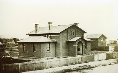 Stawell Historical Society Inc
Photograph, Court House and Cells Pleasant Creek Stawell 1866
Court House and Cells Pleasant Creek Stawell. Part of a collection of Photographs by Mr. O.G. Armstrong as commissioned by the Shire of Stawell for the Inter-colonial and Paris Exhibition in Melbourne in 1866.stawell government -
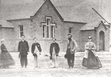 Stawell Historical Society Inc
Photograph, Pleasant Creek School Students & Some Staff 1866
Staff and Pleasant Creek 502 Common School. Part of a collection of Photographs by Mr. O.G. Armstrong as commissioned by the Shire of Stawell for the Inter-colonial and Paris Exhibition in Melbourne in 1866.stawell education -
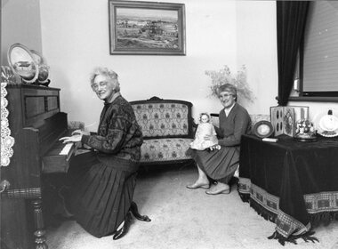
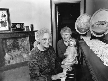 Stawell Historical Society Inc
Photograph, Pleasant Creek Court House with Stawell Historical Society President Margaret Mason at the Piano & Treasurer Mari Van Leeuwen with the doll 1989
Interior of Pleasant Creek Court House in Parlour. Stawell Historical Society President Margaret Mason Seated at the Piano. Treasurer Mari Van Leeuwen seated with doll. 1989stawell -
 Stawell Historical Society Inc
Photograph, Pleasant Creek Court House with Stawell Historical Society President Margaret Mason at the Piano & Treasurer Mari Van Leeuwen with the doll 1989
Interior of Pleasant Creek Court House in Parlour. Stawell Historical Society President Margaret Mason Seated in front of the Piano. Treasurer Mari Van Leeuwen with doll. 1989stawell -
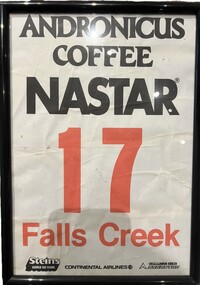 Falls Creek Historical Society
Memorabilia - NASTAR Racing Bib No. 17, 1980s
National Standard Race (abbreviated NASTAR) is the world's largest recreational ski and snowboard race program which was founded in 1968 by SKI magazine. It uses a handicap system which allow skiers and boarders of all abilities to have a go at racing and compare their times to the best racers in the world. NASTAR courses are simple, open-gated slalom courses on mostly intermediate terrain, allowing skiers of all abilities and ages to experience racing. The NASTAR race course at Falls Creek is still the home of the Rossignol Children's Cup and the Cranky Charlie Cup each year, conditions permitting.This item is significant because it is linked to the NASTAR events held at Falls Creek throughout the 1980s.A paper number bib used by a participant in the NASTAR ski event at Falls Creek. It is primarily black and white, with the number and Falls Creek printed in red. It is in a frame under glass. It bears the names of major sponsors.ANDRONICUS COFFEE NASTAR 7 FALLS CREEK Steins World Ski Tours Continental Airlines Challenge Series DYNASTARnastar racing, falls creek race club -
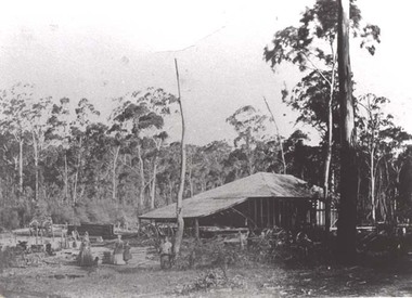 Stawell Historical Society Inc
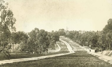
Photograph, Saw Mills at Childe’s Glenbower Creek in Halls Gap 1866
Saw Mills Halls Gap (Childe’s Glenbower Creek). Part of a collection of Photographs by Mr. O.G. Armstrong as commissioned by the Shire of Stawell for the Inter-colonial and Paris Exhibition in Melbourne in 1866.stawell industry -
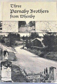 Wodonga & District Historical Society Inc
Book - Three Parnaby Brothers from Whenby, Julie Walker and Judy Crook, 2000
This book documents the story of the Parnaby Brothers who migrated to Australia from Whenby in North Yorkshire, England via Natal in South Africa. They settled in the Wodonga district of Victoria. The dedication on page 3 of the book says "To George, William and Matthew Parnaby. We can only wonder at the adventurous spirit, courage and fortitude of the three brothers who arrived in this country with an ambition to better themselves and provide for their families." George arrived at Port Melbourne from Port Natal on 11 January 1864. On the same voyage was his brother William and a nephew Charles. George and his wife Rachel settled at Howlong on the Victoria/NSW border where he worked as a farmer and labourer. George died at Howlong on 26 JUne 1887. William and his son Charles settled in Albury. In 1869/70 he was listed as a property owner at Wooragee, including a house, farm and vineyard. William died in Albury on 20 February 1894. Matthew originally arrived in Hobsons Bay, Victoria in 1854. After 6 years on the goldfields he returned to South Africa and then to England to marry. They eventually returned to Australia in 1863. After some time in Melbourne, Matthew moved to Belvoir (Wodonga). By August 1877 he owned 104 acres of grazing land at House Creek. He steadily became one of the most successful farmers in the district and increased his landholdings. He spent the remainder of his life in Wodonga where he served as a member of the Shire Council for some years. Matthew never forgot his birthplace and called his property "Whenby Grange". He died in Wodonga on 7 October 1903.A volume of 342 pages, including photos and maps. The cover includes images of the town of Whenby, maps and the grave of Matthew Parnaby who died in Wodonga on 7 October 1903.This book documents the story of the Parnaby Brothers who migrated to Australia from Whenby in North Yorkshire, England via Natal in South Africa. They settled in the Wodonga district of Victoria. The dedication on page 3 of the book says "To George, William and Matthew Parnaby. We can only wonder at the adventurous spirit, courage and fortitude of the three brothers who arrived in this country with an ambition to better themselves and provide for their families." George arrived at Port Melbourne from Port Natal on 11 January 1864. On the same voyage was his brother William and a nephew Charles. George and his wife Rachel settled at Howlong on the Victoria/NSW border where he worked as a farmer and labourer. George died at Howlong on 26 JUne 1887. William and his son Charles settled in Albury. In 1869/70 he was listed as a property owner at Wooragee, including a house, farm and vineyard. William died in Albury on 20 February 1894. Matthew originally arrived in Hobsons Bay, Victoria in 1854. After 6 years on the goldfields he returned to South Africa and then to England to marry. They eventually returned to Australia in 1863. After some time in Melbourne, Matthew moved to Belvoir (Wodonga). By August 1877 he owned 104 acres of grazing land at House Creek. He steadily became one of the most successful farmers in the district and increased his landholdings. He spent the remainder of his life in Wodonga where he served as a member of the Shire Council for some years. Matthew never forgot his birthplace and called his property "Whenby Grange". He died in Wodonga on 7 October 1903.parnaby family, whenby england, whenby grange wodonga -
 Ringwood and District Historical Society
Photograph, Maroondah Highway East, Ringwood- 1900. Sandy Creek Bridge, Maroondah Hwy
3 photographs ( 2 large black and white, 1 small sepia)Written on all copies: "New Sandy Creek Bridge". Typed below large photograph: "Maroondah Highway Ringwood looking east. To right of bridge is now Ringwood Lake. Mount Dandenong Road turnoff to right at top of rise with antimony mine in background - 1900". -
 Lake Bolac & District Historical Society
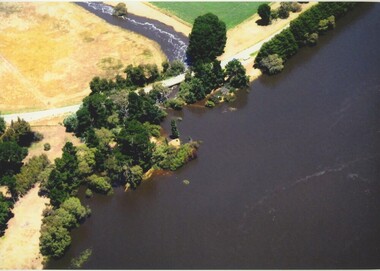
Colour photograph, Jan. 2011 Flood, Lake Bolac and Salt Creek
Jan. 2011 Flood. Debouchment from Lake Bolac into Salt Creek through the natural overflow (centre) and the channel (front left) dug in the 1920's. Photograph courtesy Bill Sharp.lake bolac, salt creek, flood, sharp. -
 Stawell Historical Society Inc
Photograph, Presbyterian Church, Reefs Pleasant Creek, built 1860
Presbyterian Church Reefs Pleasant Creek. Built 1860. Part of a collection of Photographs by Mr. O.G. Armstrong as commissioned by the Shire of Stawell in 1866 for the Inter-colonial and Paris Exhibition in Melbourne in 1866.stawell religion -
 Stawell Historical Society Inc
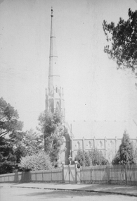
Photograph, St. Matthew’s Presbyterian Church
St. Matthew’s Church showing footpath and fence. The church is located in Scallon Street Stawell. St. Matthew's church was erected in 1868. The Spire was completed in March 1869 and the Church was dedicated on 11th April 1869. Now the United Church. Large photo of St. Matthew's Church taken from a post card in Album 13. p.28. The photo similar to 121.4 but shows the road, footpath and gate way in the picket fence with trees in the landscape.POST CARD The "Merle Studio" Main Street Stawell. stawell religion -
 Eltham District Historical Society Inc
Photograph, Fay Bridge, Diamond Creek in flood at the Bridge Street Bridge, Eltham, c.2004
View looking southeast from Alistair Knox Park (west). The Diamond Creek Trail footbridge is completely submerged. Significant flood events occurred Nov-Dec 2004 and Jan-Feb 2005.fay bridge collection, 2004, bridge street bridge, diamond creek (creek), floods, floodwater -
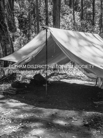 Eltham District Historical Society Inc
Photograph - Negative, Lewis Tulk, Possibly 6 Preston Salvation Army Scout Group at Dixons Creek, c.1980
Metal pole tent belonged to 6 Preston Salvation Army Scout group who used to camp in Dixons Creek Donated by Lewis Tulk, former Scout Area Training Commisioner for Leaders.scouts victoria, scout leader training, lewis tulk collection, yarra batman area, 6 preston salvation army scouts, dixons creek, scan - 120 format 6x4.5 negative -
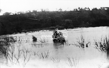 Eltham District Historical Society Inc
Negative - Photograph, Diamond Creek in Flood, c.1916
Original information recorded with this image suggested the date was 1918 however that was not a significant flood year for the the Diamond Creek at Hurstbridge. Of more significance was 1916. This scene is understood to be somewhere near Wattle Glen and Hurstbridge.This photo forms part of a collection of photographs gathered by the Shire of Eltham for their centenary project book,"Pioneers and Painters: 100 years of the Shire of Eltham" by Alan Marshall (1971). The collection of over 500 images is held in partnership between Eltham District Historical Society and Yarra Plenty Regional Library (Eltham Library) and is now formally known as the 'The Shire of Eltham Pioneers Photograph Collection.' It is significant in being the first community sourced collection representing the places and people of the Shire's first one hundred years.Digital image 4 x 5 inch B&W Negshire of eltham pioneers photograph collection, hurstbridge, wattle glen, floods, diamond creek (creek) -
 Stawell Historical Society Inc
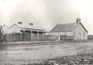
Photograph, Literary Institute at Pleasant Creek
Literary Institute at Pleasant Creek, Stawell West. Built in 1868 and classified as part of a group by National Trust buildings. Worksheet notes state the building is one of the earliest known cavity wall buildings.Early black & white photograph of the two story Literary Institute built in 1868. Man, or boy standing on footpath near stone fence.stawell -
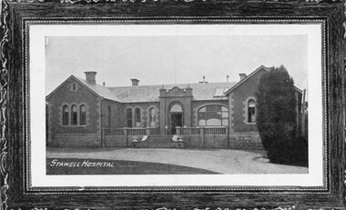 Stawell Historical Society Inc
Postcard, Pleasant Creek -- Stawell Hospital & Benevolent Asylum c1890 -- Postcard
Pleasant Creek Hospital and Benevolent Asylum. Stawell Hospital First Permanent Building Semco Series Postcard. Writing on back short note to Mrs Irvine of Great Western from Jinnie Kinsellastawell hospital medical -
 Wodonga & District Historical Society Inc
Album - Ringer's River by Des Martin - Plate 17 - Drawing the Calcutta Sweep for Piney Creek Picnic Race Club
On the morning of the Piney Creek Picnic Race Club's annual meeting Squire Pilkington of Piney Creek Homestead, President of the Club, draws the Calcutta Sweep. Graeme Oliver nominates his horse for the Ladies' Bracelet in the name of Elaine Montieth and O'Day, as Manager for MacLough gives his nomination to her friend Penny Sefton whom Reg Apperton is sparking. With Keiran O'Hara for his rider, Squire Pilkington nominates in the name of his pretty niece, Susan Bundy. Harry MacLean as Squire Pilkington. Bill Tenteye as the Hon. Secretary Jim McGrath as the Hon. Treasurer.The album and images are significant because they document literature written by a prominent member of the Wodonga community. The presentation of this precis was supported by several significant district families and individuals.Ringer's River Album Coloured photo Plate 17des martin, many a mile, ringer's river, northeast victoria stories -
 Eltham District Historical Society Inc
Photograph, Main Street, Diamond Creek near intersection with Cowin Street, c.1970
Looking slightly south east towards the bridge over the Diamond Creek. An FE (1956-58) or FC (1958-60) Holden is parked outside the Food Centre on left which is now Nillumbik CellarsBlack and white copy of photo printed on glossy photographic paper 30.5 x 40.5 cm (12 x 16 inch); image size approx. 18.5 x 28 cmcar, diamond creek, diamond creek tennis club, diamond street, dr edward rae cordner snr, ford model t, motor vehicles -
 Eltham District Historical Society Inc
Photograph, Bridge over Smiths Gully Creek, Heidelberg-Kinglake Road, St Andrews, c.1968, 1968c
Looking northwest from Smiths Gully creek at the bridge on Scott Street (Heidelberg-Kinglake Road) just east of the intersection with Burns Street (Kangaroo Ground-St Andrews Road), and the St Andrews MarketBlack and white photograph (x 2)H-KL at KG SAbridge, burns street, heidelberg-kinglake road, infrastructure, kangaroo ground-st andrews road, scott street, shire of eltham, shire of eltham infrastructure, smiths gully creek, st andrews, st andrews market -
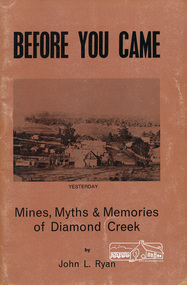 Eltham District Historical Society Inc
Book, John L. Ryan, Before you came : mines, myths & memories of Diamond Creek / by John L. Ryan, 1972
Subtitled mines, myths and memories of Diamond Creek the book covers the following topics: early days, first settlers, Nillumbik- the town, state school, the churches, growth of a town, early pioneers and stories of the past. PhotographsPaperback; 55 p. : ill., port. ; 21 cm.ISBN 0959895019diamond creek, nillumbik, gold mining, gold miners -
 Eltham District Historical Society Inc
Photograph, Kinglake National Park, Tangle Creek
Bushwalkers and hikers pose for a photograph in the heavily forested area of Kinglake National Park near the little known Tangle Creek, circa 1925. The Kinglake National Park was established on 11,300 acres in the Shire of Eltham in 1928.This photo forms part of a collection of photographs gathered by the Shire of Eltham for their centenary project book, "Pioneers and Painters: 100 years of the Shire of Eltham" by Alan Marshall (1971). The collection of over 500 images is held in partnership between Eltham District Historical Society and Yarra Plenty Regional Library (Eltham Library) and is now formally known as 'The Shire of Eltham Pioneers Photograph Collection.' It is significant in being the first community sourced collection representing the places and people of the Shire's first one hundred years.Digital imagesepp, shire of eltham pioneers photograph collection, kinglake, kinglake national park, tangle creek, walking, hiking, bushwalk, ferns -
 Eltham District Historical Society Inc
Photograph, Construction of the new concrete bridge over the Diamond Creek on Main Road, Eltham, c.May 1926
Construction of the new concrete bridge over the Diamond Creek on Main Road, Eltham, c.May 1926. Viewed from northern approach looking east, the access drive running off Antoinette Boulevard parallel to Main Road is visible as well as the power lines that used to run in front of Eltham Park (Eltham Lower Park). Also visible is a tree situated beside the roadway. It is believed this is the same tree that remains today as a dead tree trunk immediately adjacent to the road verge armco near the corner of Antoinette Boulevard. The original long suspension bridge over the Diamond Creek on Main Road at Eltham collapsed during flooding of the Diamond Creek on October 13 and 14, 1923. The original bridge was built around 1840 for the coach road when Cobb & Co.'s coach was the only conveyance between Eltham and Melbourne. Widespread damage was done in Melbourne and surrounding areas by floods resulting from the overflow of the Yarra at many points along its banks. A temporary bridge rigged up was severely damaged by the flooding of the creek and was closed to vehicular traffic in April 1924. A new concrete bridge was constructed to replace it and by May 1926 all the concrete piles and abutments had been completed. The bridge was finally completed and opened for traffic in September 1926, almost three years after it initially collapsed.This photo forms part of a collection of photographs gathered by the Shire of Eltham for their centenary project book,"Pioneers and Painters: 100 years of the Shire of Eltham" by Alan Marshall (1971). The collection of over 500 images is held in partnership between Eltham District Historical Society and Yarra Plenty Regional Library (Eltham Library) and is now formally known as the 'The Shire of Eltham Pioneers Photograph Collection.' It is significant in being the first community sourced collection representing the places and people of the Shire's first one hundred years.Photo print 9 x 12.5 cmshire of eltham pioneers photograph collection, eltham, bridge, diamond creek (creek), eltham south, main road bridge, wingrove park, antoinette boulevard, significant tree, cement mixer, bridge construction -
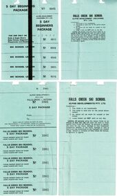
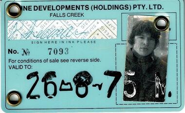 Falls Creek Historical Society
Lift Tickets Falls Creek 1975
SKI TICKETS Before tows and lifts were introduced at Falls Creek, it could take skiers 20 minutes to climb to the Summit … but only TWO minutes to go back to the bottom. The arrival of tows, then chairlifts and T-bars changed the face of skiing forever. The first rope tow was constructed by Toni St. Elmo for the 1951 winter season. Bob Hymans installed a smaller tow for his guests at Skyline Lodge. Tows were still quite slow, so in 1956 Bob Hymans created his single chairlift. In 1958 the Village rope tow, designed by Albury engineer Jock Wilson, opened. It was financed by shareholders including Bill Griffith (Bowna Ski Club) and the Bridgford family (St. Trinian’s Ski Club). Several other tows followed including the Summit T-bar in 1961, built by Ron McCallum and operated by Alpine Developments Pty. Ltd. which was a company formed by C. H. (Bill) Bridgford. By 1982 Falls Creek was served by 16 different lifts or T-bars, all owned and operated by Alpine Developments (Holdings) Pty. Ltd. During the development of Falls Creek, different methods have been used to pay for the use of tows, lifts and T-bars … including metal tokens, single tickets, strips of tickets and season passes. The Falls Creek Historical Society Collection includes many examples of these items.These tickets are significant because they represent a stage in the management at Falls Creek Tourist Village.A laminated Identification Card and a strip of Lift tickets valid for the Nursery Pomas and Link Lift. The card expired on 26-8-75.chairlift falls creek, falls creek passes, falls creek id cards -
 Falls Creek Historical Society
Lift and Lesson Tickets Falls Creek 1980
SKI TICKETS Before tows and lifts were introduced at Falls Creek, it could take skiers 20 minutes to climb to the Summit … but only TWO minutes to go back to the bottom. The arrival of tows, then chairlifts and T-bars changed the face of skiing forever. The first rope tow was constructed by Toni St. Elmo for the 1951 winter season. Bob Hymans installed a smaller tow for his guests at Skyline Lodge. Tows were still quite slow, so in 1956 Bob Hymans created his single chairlift. In 1958 the Village rope tow, designed by Albury engineer Jock Wilson, opened. It was financed by shareholders including Bill Griffith (Bowna Ski Club) and the Bridgford family (St. Trinian’s Ski Club). Several other tows followed including the Summit T-bar in 1961, built by Ron McCallum and operated by Alpine Developments Pty. Ltd. which was a company formed by C. H. (Bill) Bridgford. By 1982 Falls Creek was served by 16 different lifts or T-bars, all owned and operated by Alpine Developments (Holdings) Pty. Ltd. During the development of Falls Creek, different methods have been used to pay for the use of tows, lifts and T-bars … including metal tokens, single tickets, strips of tickets and season passes. The Falls Creek Historical Society Collection includes many examples of these items.These tickets are significant because they represent a stage in the management at Falls Creek Tourist Village.A collection illustrating the range of tickets available for skiers in the 1980 Winter Season.falls creek tickets, falls creek tourism