Showing 23102 items matching "sardine-creek"
-
 National Vietnam Veterans Museum (NVVM)
Booklet, Nasho: a pictorial record of my National Service: 1967-1968, 2015
Contains Photograph of Robert's time in Vietnam.vietnam war - 1961-1975 - soldiers - australian, vietnam war, 1961 - 1975, personal narratives - australian -
National Vietnam Veterans Museum (NVVM)
Booklet, The Book in a Box
A biographical history of the author's time in Vietnam.vietnam war, 1961 - 1975, personal narratives - australian, vietnam war, 1961 - 1975 -- veterans -- australia -
National Vietnam Veterans Museum (NVVM)
Film - Film, DVD, Vietnam: America's Conflict: historical documentaries, 2008
Box of 4 Film, DVD'svietnam war, 1961 - 1975 - united states, vietnam war, 1961-1975 - aerial operations - american -
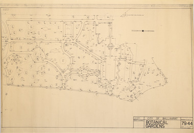 Friends of Ballarat Botanical Gardens History Group
Plan - Survey Plan A, G. Creek, City of Ballarat Botanical Gardens
HistoricSurvey map on papersurvey map, city of ballaarat, ballarat botanical gardens -
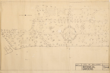 Friends of Ballarat Botanical Gardens History Group
Plan - Survey Plan A, G. Creek, City of Ballarat Botanical Gardens
HistoricSurvey map on papersurvey map, city of ballaarat, ballarat botanical gardens -
Box Hill Historical Society
Book, Robert Creek, I'm a Bokky Boy: a local history research project, 2018
Description of the Creek family of Box Hill 1947-1959 and beyondSpiral bound; approx. 160 pages. Includes indices; b&w photos and illustrationsDescription of the Creek family of Box Hill 1947-1959 and beyondcreek> robert, box hill, family history -
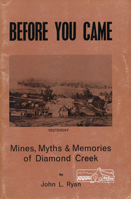 Eltham District Historical Society Inc
Book, John L. Ryan, Before you came : mines, myths & memories of Diamond Creek / by John L. Ryan, 1972
Subtitled mines, myths and memories of Diamond Creek the book covers the following topics: early days, first settlers, Nillumbik- the town, state school, the churches, growth of a town, early pioneers and stories of the past. PhotographsPaperback; 55 p. : ill., port. ; 21 cm.ISBN 0959895019diamond creek, nillumbik, gold mining, gold miners -
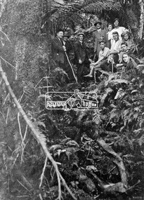 Eltham District Historical Society Inc
Photograph, Kinglake National Park, Tangle Creek
Bushwalkers and hikers pose for a photograph in the heavily forested area of Kinglake National Park near the little known Tangle Creek, circa 1925. The Kinglake National Park was established on 11,300 acres in the Shire of Eltham in 1928.This photo forms part of a collection of photographs gathered by the Shire of Eltham for their centenary project book, "Pioneers and Painters: 100 years of the Shire of Eltham" by Alan Marshall (1971). The collection of over 500 images is held in partnership between Eltham District Historical Society and Yarra Plenty Regional Library (Eltham Library) and is now formally known as 'The Shire of Eltham Pioneers Photograph Collection.' It is significant in being the first community sourced collection representing the places and people of the Shire's first one hundred years.Digital imagesepp, shire of eltham pioneers photograph collection, kinglake, kinglake national park, tangle creek, walking, hiking, bushwalk, ferns -
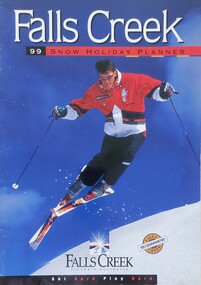 Falls Creek Historical Society
Magazine - Falls Creek 99 Snow Holiday Planner
Part of an annual marketing campaign, this booklet was designed to provide information for planning a holiday at Falls Creek for the winter of 1999. It includes details about activities, facilities and accommodation in the Village as well as contact information to make necessary bookings.This item is important as it documents seasonal activities at Falls Creek Alpine ResortA booklet containing detailed information and images including a map, prices and booking details.falls creek, winter sport, 1990s, falls creek marketing -
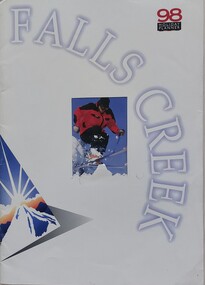 Falls Creek Historical Society
Magazine - Falls Creek 98 Holiday Planner
Part of an annual marketing campaign, this booklet was designed to provide information for planning a holiday at Falls Creek for the winter of 1998. It includes details about activities, facilities and accommodation in the Village as well as contact information to make necessary bookings.This item is important as it documents seasonal activities at Falls Creek Alpine ResortA booklet containing detailed information and images including a map, prices and booking details.falls creek, victoria, winter sport, falls creek marketing -
 Falls Creek Historical Society
Booklet - Falls Creek 2002
Part of an annual marketing campaign, this booklet was designed to provide information for planning a holiday at Falls Creek for the winter of 2002. It includes details about activities, facilities and accommodation in the Village as well as contact information to make necessary bookings.This item is important as it documents seasonal activities at Falls Creek Alpine Resort An A4 sized marketing booklet, including images and advertising information printed on glossy paper.victoria, winter sport, falls creek marketing, falls creek 2002 -
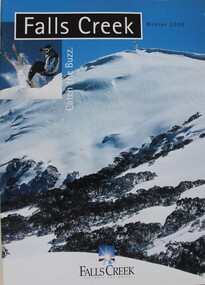 Falls Creek Historical Society
Booklet - Falls Creek Winter 2000 - Catch the Buzz
Part of an annual marketing campaign, this booklet was designed to provide information for planning a holiday at Falls Creek for the winter of 2000. It includes details about activities, facilities and accommodation in the Village as well as contact information to make necessary bookings.This item is important as it documents seasonal activities at Falls Creek Alpine Resort An A4 sized marketing booklet, including images and advertising information printed on glossy paper.falls creek, winter sport, falls creek marketing -
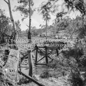
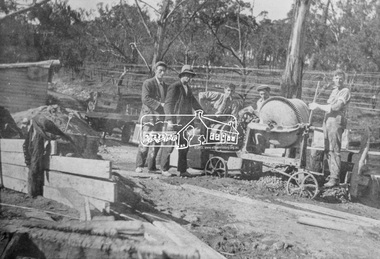 Eltham District Historical Society Inc
Photograph, Construction of the new concrete bridge over the Diamond Creek on Main Road, Eltham, c.May 1926
Construction of the new concrete bridge over the Diamond Creek on Main Road, Eltham, c.May 1926. Viewed from northern approach looking east, the access drive running off Antoinette Boulevard parallel to Main Road is visible as well as the power lines that used to run in front of Eltham Park (Eltham Lower Park). Also visible is a tree situated beside the roadway. It is believed this is the same tree that remains today as a dead tree trunk immediately adjacent to the road verge armco near the corner of Antoinette Boulevard. The original long suspension bridge over the Diamond Creek on Main Road at Eltham collapsed during flooding of the Diamond Creek on October 13 and 14, 1923. The original bridge was built around 1840 for the coach road when Cobb & Co.'s coach was the only conveyance between Eltham and Melbourne. Widespread damage was done in Melbourne and surrounding areas by floods resulting from the overflow of the Yarra at many points along its banks. A temporary bridge rigged up was severely damaged by the flooding of the creek and was closed to vehicular traffic in April 1924. A new concrete bridge was constructed to replace it and by May 1926 all the concrete piles and abutments had been completed. The bridge was finally completed and opened for traffic in September 1926, almost three years after it initially collapsed.This photo forms part of a collection of photographs gathered by the Shire of Eltham for their centenary project book,"Pioneers and Painters: 100 years of the Shire of Eltham" by Alan Marshall (1971). The collection of over 500 images is held in partnership between Eltham District Historical Society and Yarra Plenty Regional Library (Eltham Library) and is now formally known as the 'The Shire of Eltham Pioneers Photograph Collection.' It is significant in being the first community sourced collection representing the places and people of the Shire's first one hundred years.Photo print 9 x 12.5 cmshire of eltham pioneers photograph collection, eltham, bridge, diamond creek (creek), eltham south, main road bridge, wingrove park, antoinette boulevard, significant tree, cement mixer, bridge construction -
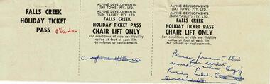
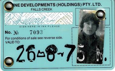 Falls Creek Historical Society
Lift Tickets Falls Creek 1975
SKI TICKETS Before tows and lifts were introduced at Falls Creek, it could take skiers 20 minutes to climb to the Summit … but only TWO minutes to go back to the bottom. The arrival of tows, then chairlifts and T-bars changed the face of skiing forever. The first rope tow was constructed by Toni St. Elmo for the 1951 winter season. Bob Hymans installed a smaller tow for his guests at Skyline Lodge. Tows were still quite slow, so in 1956 Bob Hymans created his single chairlift. In 1958 the Village rope tow, designed by Albury engineer Jock Wilson, opened. It was financed by shareholders including Bill Griffith (Bowna Ski Club) and the Bridgford family (St. Trinian’s Ski Club). Several other tows followed including the Summit T-bar in 1961, built by Ron McCallum and operated by Alpine Developments Pty. Ltd. which was a company formed by C. H. (Bill) Bridgford. By 1982 Falls Creek was served by 16 different lifts or T-bars, all owned and operated by Alpine Developments (Holdings) Pty. Ltd. During the development of Falls Creek, different methods have been used to pay for the use of tows, lifts and T-bars … including metal tokens, single tickets, strips of tickets and season passes. The Falls Creek Historical Society Collection includes many examples of these items.These tickets are significant because they represent a stage in the management at Falls Creek Tourist Village.A laminated Identification Card and a strip of Lift tickets valid for the Nursery Pomas and Link Lift. The card expired on 26-8-75.chairlift falls creek, falls creek passes, falls creek id cards -
 Falls Creek Historical Society
Lift and Lesson Tickets Falls Creek 1980
SKI TICKETS Before tows and lifts were introduced at Falls Creek, it could take skiers 20 minutes to climb to the Summit … but only TWO minutes to go back to the bottom. The arrival of tows, then chairlifts and T-bars changed the face of skiing forever. The first rope tow was constructed by Toni St. Elmo for the 1951 winter season. Bob Hymans installed a smaller tow for his guests at Skyline Lodge. Tows were still quite slow, so in 1956 Bob Hymans created his single chairlift. In 1958 the Village rope tow, designed by Albury engineer Jock Wilson, opened. It was financed by shareholders including Bill Griffith (Bowna Ski Club) and the Bridgford family (St. Trinian’s Ski Club). Several other tows followed including the Summit T-bar in 1961, built by Ron McCallum and operated by Alpine Developments Pty. Ltd. which was a company formed by C. H. (Bill) Bridgford. By 1982 Falls Creek was served by 16 different lifts or T-bars, all owned and operated by Alpine Developments (Holdings) Pty. Ltd. During the development of Falls Creek, different methods have been used to pay for the use of tows, lifts and T-bars … including metal tokens, single tickets, strips of tickets and season passes. The Falls Creek Historical Society Collection includes many examples of these items.These tickets are significant because they represent a stage in the management at Falls Creek Tourist Village.A collection illustrating the range of tickets available for skiers in the 1980 Winter Season.falls creek tickets, falls creek tourism -
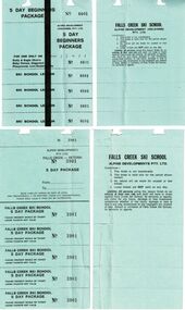
 Falls Creek Historical Society
Document - Proofs for Lift and Ski School Tickets Falls Creek, 1968
SKI TICKETS Before tows and lifts were introduced at Falls Creek, it could take skiers 20 minutes to climb to the Summit … but only TWO minutes to go back to the bottom. The arrival of tows, then chairlifts and T-bars changed the face of skiing forever. The first rope tow was constructed by Toni St. Elmo for the 1951 winter season. Bob Hymans installed a smaller tow for his guests at Skyline Lodge. Tows were still quite slow, so in 1956 Bob Hymans created his single chairlift. In 1958 the Village rope tow, designed by Albury engineer Jock Wilson, opened. It was financed by shareholders including Bill Griffith (Bowna Ski Club) and the Bridgford family (St. Trinian’s Ski Club). Several other tows followed including the Summit T-bar in 1961, built by Ron McCallum and operated by Alpine Developments Pty. Ltd. which was a company formed by C. H. (Bill) Bridgford. By 1982 Falls Creek was served by 16 different lifts or T-bars, all owned and operated by Alpine Developments (Holdings) Pty. Ltd. During the development of Falls Creek, different methods have been used to pay for the use of tows, lifts and T-bars … including metal tokens, single tickets, strips of tickets and season passes. The Falls Creek Historical Society Collection includes many examples of these items.These items are significant because they demonstrate the steps taken to create early lift and lesson tickets.These items are the proofs for tickets to be printed for the 1968 season. Some tickets have handwritten notes to advise printer.falls creek tickets, falls creek lifts -
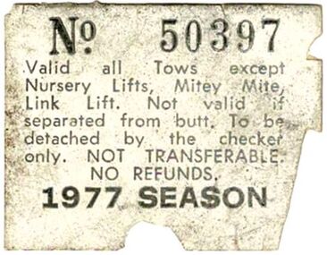 Falls Creek Historical Society
Falls Creek Lift Pass 1977
SKI TICKETS Before tows and lifts were introduced at Falls Creek, it could take skiers 20 minutes to climb to the Summit … but only TWO minutes to go back to the bottom. The arrival of tows, then chairlifts and T-bars changed the face of skiing forever. The first rope tow was constructed by Toni St. Elmo for the 1951 winter season. Bob Hymans installed a smaller tow for his guests at Skyline Lodge. Tows were still quite slow, so in 1956 Bob Hymans created his single chairlift. In 1958 the Village rope tow, designed by Albury engineer Jock Wilson, opened. It was financed by shareholders including Bill Griffith (Bowna Ski Club) and the Bridgford family (St. Trinian’s Ski Club). Several other tows followed including the Summit T-bar in 1961, built by Ron McCallum and operated by Alpine Developments Pty. Ltd. which was a company formed by C. H. (Bill) Bridgford. By 1982 Falls Creek was served by 16 different lifts or T-bars, all owned and operated by Alpine Developments (Holdings) Pty. Ltd. During the development of Falls Creek, different methods have been used to pay for the use of tows, lifts and T-bars … including metal tokens, single tickets, strips of tickets and season passes. The Falls Creek Historical Society Collection includes many examples of these items.This ticket is significant because it represents a stage in the management at Falls Creek Tourist Village.Pass No 50397 for the 1977 Season. It was valid for all Tows except the Nursery Lifts, Mitey Mite and the Link Lift. ski lift, lift passes, season pass -
 Eltham District Historical Society Inc
Negative - Photograph, J.A. McDonald, Eltham-Diamond Creek Road, 21 Sep 1959
Bridge construction Eltham-Diamond Creek road over the Diamond Creek (Wattletree Road), Eltham, September 1959 After some delay in receiving funds, work started on the bridge approaches in early September 1959. Traffic was still using the old bridge upstream. On Sunday, 20 September 1959, heavy flooding occurred in the stream and at 3:53 pm the old bridge was washed out. This photo was taken the day after. To the left is the Diamond Creek side abutment for the new Wattletree Road bridge under construction. Where the trucks are parked is near the present-day intersection with Progress Road. At the time Progress Road did not exist and was merely a road reserve on the map. The bridge was originally built as a replacement for an older private bridge built by a man named Foley around 1880. In 1911 Heidelberg and Eltham agreed to share the costs to build a new bridge. Construction began in June 1915 and it was officially opened by Cr. Taylor on Cup Day, November 1915.Record of various Shire of Eltham infrastructure works undertaken during the period of 1952-1962 involving bridge and road reconstruction projects, sometimes with Eltham Shire Council Project Reference numbers quoted. It was during this period that a number of significant improvements were made to roads and new bridges constructed within the shire that remain in place as of present day (2022). In many situations, the photos provide a tangible visible record of infrastructure that existed throughout the early days of the Shire. The album was put together by or under the direction of the Shire Engineer, J.A. McDonald.infrastructure, shire of eltham, bridge construction, bridge, diamond creek (creek), eltham, eltham north, glen park bridge, 1959-09-21, flood damage, wattletree road bridge -
 Greensborough Historical Society
Photograph, Cr Jessop opens a venue in Diamond Creek
This undated photograph shows Councillor Cecil Jessop, as Mayor of Heidelberg, opening a venue in Diamond Creek, possibly a pool. Photographed b G. Cox, this photograph appeared in the Diamond Valley Story, published by the Shire of Diamond Valley in 1979.Large black and white photograph of a group of people at an official event.diamond creek, cecil jessop, shire of diamond valley -
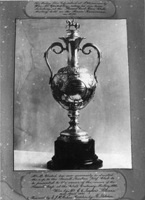 Stawell Historical Society Inc
Photograph, Stawell Turf Club a Silver Cup won at Pleasant Creek race club meeting held at Stawell race course 1878
Stawell Turf Club a Silver Cup won at Pleasant Creek race club meeting held at Stawell race course 1878. Valued 40 pounds. Won by Wm McClinock Esq riding his own horse "Salisbury"stawell sport -
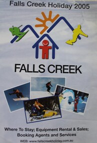 Falls Creek Historical Society
Booklet - Falls Creek Holiday 2005
Part of an annual marketing campaign, this booklet was designed to provide information for planning a holiday at Falls Creek for the winter of 2005. It includes details about activities, facilities and accommodation in the Village as well as maps and contact information to make necessary bookings.This item is important as it documents seasonal activities at Falls Creek Alpine Resort An A4 sized marketing booklet, including images and advertising information printed in colour and black and white.falls creek marketing, falls creek 2005, falls creek accommodation -
 Eltham District Historical Society Inc
Photograph, Tess Justine (Nillumbik Shire Council), Construction work on replacement of Murray's Bridge over the Diamond Creek, Eltham North, 31 Mar 2022
Construction work on replacement of Murray's Bridge over the Diamond Creek on the Diamond Creek Trail Mary (Sweeney) Murray and John Wright Murray selected 80 acres, Lot C Section 16 and Lot 5 Section 17 Parish of Nillumbik, under an occupation license in 1866. John died in 1867 and freehold was granted to his son John in 1873. The farm was known as ‘Laurel Hill’. John Junior was an Eltham Shire councillor and sometime president from 1887 up until 1897. He added Lot A Section 16 to the farm in ca1888. John and his younger brother James arranged to rent/purchase Lot B Section 17, across Diamond Creek to the west, in ca1900. It appears that John and James farmed separately for a few years, with a new homestead built for James ad family on the high point of Lot B Section 17 in ca1910. John sold off Lot 5 Section 17 in 1912. When John died in 1912 James took over the land on both sides of the Diamond Creek. The old homestead on the west side of the Creek disappeared. A farm bridge over Diamond Creek from this period may have been located close to the northern boundary of the farm. John Langlands, owner of the farm known as ‘Ihurst’ on the west side of Diamond Creek to the south of the Murray’s land, died in 1907. In 1909 his land was then subdivided into 100 lots to become the ‘Glen Park Estate’. Other similar subdivisions of nineteenth century farms around Eltham in this period included the ‘Franktonia (or Beard’s) Estate’ to the northeast and ‘Bonsack’s Estate’ between Eltham and Greensborough. Soon after the opening of the railway extension line from Eltham to Hurstbridge in 1912, Glen Park and nearby residents including James Murray agitated for a railway station or siding to be located half-way between Eltham and Hurstbridge, so that the Glen Park residents who used the railway daily did not have to walk into the Eltham or Hurstbridge stations. Some believed Coleman’s Corner (opposite Edendale Farm) was an appropriate spot for the platform. James Murray was among those who thought the railway should be located on his land, closer to half-way between Eltham and Hurstbridge stations. The Railways Commissioners warned that the locals would have to fund these works themselves. The Glen Park Estate residents initially had difficulty accessing Eltham by road, with only an old low-level bridge over Diamond Creek at the south end of their estate. A new timber trestle bridge across the creek, now on Wattletree Road, was opened in 1915. Road access to the north was gained in 1927 when the new Murray’s Road, which crossed the Murray’s land, was built. Residents continued to agitate for a Glen Park station. By 1926 the Railways Commissioners’ preferred site was on the Murray’s land. They arranged an estimate of cost of a full-length platform. The estimate was too much for the locals, who in 1928 argued unsuccessfully for a shorter and hence cheaper platform. By 1929 Murray had agreed to donate the land, but the locals would still have to fund the works. Murray decided, unilaterally it would appear, to commence work on a timber trestle road bridge over Diamond Creek to link the new Murray Road to the proposed station. Late in 1929 he stopped work on the bridge, for reasons unknown, but started work again and completed the bridge in 1931. There is no further newspaper evidence of the campaign for the Glen Park station until 1939, when Murray and another local, Mr Maxwell, met the Railways Commissioner. The Glen Park locale now included 45 homes on the west side of the creek and 20 on the Eltham side. Most of the residents used the train every day. The Commissioner remained adamant that only a full-length platform could be built for safety reasons. It appears the campaign dissolved at this point. The increasing move to cars may have had an impact. There is no evidence of Murray’s bridge ever being connected to Murray’s Road, or of it having wide use for any purpose by locals. James Murray died in 1947 and the farm was taken over by his son James (Jim). Jim started to sell off parts of the farm in the 1980s, retaining a few acres around the ca1910 homestead and building a new house there. Recreation reserves were established along the creek. In ca1990 Murray’s bridge was renovated with steel girders as part of a bike/pedestrian path in the reserve. The old farmhouse was demolished in ca2014. Born digital image (5)diamond creek (creek), diamond creek trail, murrays bridge, ‘laurel hill’, john wright murray, mary (sweeney) murra, john murray jnr, james murray, john langlands, ‘ihurst’, ‘glen park estate’, beard's estate, franktonia, bonsack's estate, glen park estate, glen park railway station -
 Eltham District Historical Society Inc
Photograph, Possibly William and Harold Sinclair of Diamond Creek
Twin sons of Harry Sinclair who came to the district from Scotland in 1860. William and Harry were born 25 Feb 1869 in Diamond Creek. William died 12 Sep 1943 at Heidelberg and Harry died 1947 at GreensboroughBlack and white copy of photo printed on glossy photographic paper 30.5 x 40.5 cm (12 x 16 inch); image size approx. 18.5 x 28 cmdiamond creek, harold sinclair, henry colling sinclair, henry sinclair, william alexander sinclair, william sinclair -
Lorne Historical Society
Domestic object - Whisky Bottle, Moggs Creek Whisky bottle
The Moggs Creek Moving Clickers Society wee responsible for perpetuating the hoax that Sir Samuel Moggs discovered Aireys Inlet before the arrival of the First Fleet. In 1959 they erected a statue to Sir Samual Moggs and also made this whisky bottle.Brown glass whisky bottle sealed with cork and red wax. The black and white printed label identifies it as Moggs Lighthouse , Very Old Matured Whisky dated 1763. Distilled by United Moggs Distillery Unlimited, Aireys Inlet Australia. moggs creek, sir samuel moggs -
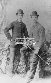
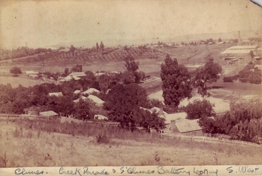 Clunes Museum
Photograph, BAWDEN PHOTOGRAPHER
SEPIA PHOTOGRAPH OF CREEK PARADE, CLUNES, AND SOUTH CLUNES BATTERYCLUNES CREEK & CLUNES BATTERY LOOKING SOUTH WESTlocal history, photography, photographs, clunes landscape -
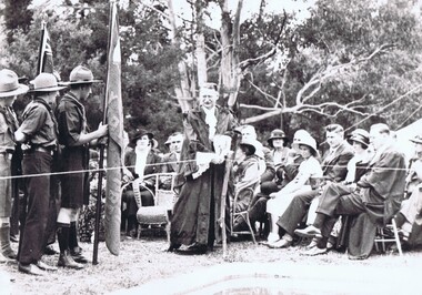
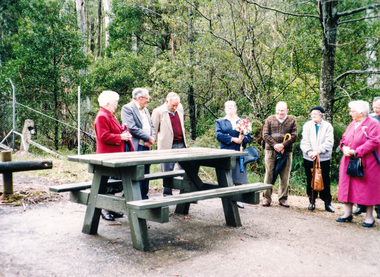 Eltham District Historical Society Inc
Photograph, Dedication of picnic table at Wilks Creek Bridge, Marysville by Marysville Historical Society, 13 October 1993, 13/10/1993
Wilks Creek Bridge was built in 1870. It was last used for heavy vehicle traffic in 1980 and left to decay until it was demolished in 2008. The last remnants of the timber structure were destroyed in the Black Saturday bushfire of 7 February 2009. [from EDHS Newsletter No. 93, November 1993:] OTHER NEWS A small group of members represented the Society at the opening of the picnic ground at the historic Wilks Creek Bridge at Marysville. The event included the launching of a booklet by our friend Ann Thomas on the history of the bridge which was located on the old Yarra Track coaching route between Eltham and Woods Point. Ann has donated a copy of the booklet to our Society.Two colour photographsactivities, marysville, wilks creek bridge -
![Photograph - Digital image, House corner Diamond Creek and St Helena Roads [Greensborough], 02/05/2013](/media/collectors/4f729f5697f83e03086015b8/items/5729b8962162f108e8de2d43/item-media/5729b8f42162f108e8de30fe/item-fit-380x285.jpg) Greensborough Historical Society
Greensborough Historical SocietyPhotograph - Digital image, House corner Diamond Creek and St Helena Roads [Greensborough], 02/05/2013
This photograph of the corner Diamond Creek and St Helena Roads was taken in 2013 to show changes over 40 years, based on Ron Reynold’s sketches in the 1973 publication 'Greensborough and Greenhills' published by Cypress Books. The house on the corner is the subject of one sketch in the book.Digital copy of colour photograph.greensborough and greenhills, st helena road greensborough, diamond creek road greensborough, ron reynolds -
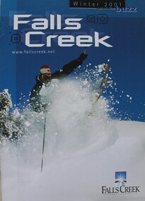 Falls Creek Historical Society
Booklet - Falls Creek Winter 2001 - Catch the Buzz
Part of an annual marketing campaign, this booklet was designed to provide information for planning a holiday at Falls Creek for the winter of 2001. It includes details about activities, facilities and accommodation in the Village as well as contact information to make necessary bookings. The slogan for 2001 was "Catch the Buzz".This item is important as it documents seasonal activities at Falls Creek Alpine Resort An A4 sized marketing booklet, including images and advertising information printed on glossy paper.skiing, ski, falls creek, victoria, school holidays, winter, snow, winter sport, 1990s, marketing, graphic design -
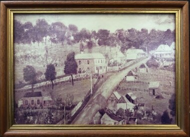 Greensborough Historical Society
Photograph - Photograph (Framed), St Helena and Diamond Creek Roads Greensborough 1889, 1889
A view of Greensborough township 1889, painted from the corner of St Helena Road and Diamond Creek Roads. This copy has been cropped from the original to show lower Main Street and Marble hall. The original of this painting is owned by Greensborough Primary School.From the John Mackey collection. this item was displayed at the offices of Ryan, Mackey and Kelly, solicitors, Main Street Greensborough.Small timber-framed photograph of road and houses, sepia.greensborough, main street greensborough, marble hall greensborough, arthur elliott, john mackey -
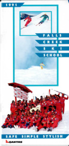 Falls Creek Historical Society
Booklet - 1991 Falls Creek Ski School
An information booklet promoting programs at the Falls Creek Ski School for 1991. It emphasises the "Triple S" way of conducting lessons - Safe, Simple and Stylish". The different kinds of lessons and programs are clearly explained as well as the Ski School class levels. The booklet is endorsed by Qantas.This item is important because it documents seasonal activities at Falls Creek Alpine ResortA small booklet combining information and images printed on glossy paper.falls creek marketing, falls creek ski school, ski lessons, winter in falls creek