Showing 10802 items
matching site
-
 Stawell Historical Society Inc
Photograph, Fluming Water Supply in the Grampians 1991 -- 9 Photos -- Coloured
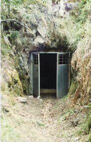
Coloured photos of Fluming Water Supply in the Grampians. a. Grampians Exit of tunnel through Mt William Range built 1874. b. Halls Gap Fyan's Creek with buried pipe from new diversion Weir Nov 24/91 (Fume Main). c. Halls Gap New Diversion Weir (Keith Phillips) Nov 24/1991. d. Halls Gap Old pipe to open flume adapter Nov 24/1991. e. Halls Gap Old metal open flume Nov24/91. f. Halls Gap Old metal flume and man made stone supporting wall. g. Halls Gap Overhanging rocks above old fume line Nov 24/1991. h. Halls Gap Old pipe to open flume adapter Bill Holmes Nov 24/91. i. Grampians Old hut for controlling flow valves etc. at Stawell side of Mount William Range after tunnel exit. Nine colour photographs of various views around a tunnel through a hill site.grampians water supply flume -
 Lakes Entrance Historical Society
Book, East Gippsland Regional Planning Committee, Sites of Historical Significance in the East Gippsland Region, 1980
Details of historical sites with comments about the money raising activities. History of construction..historic sites, charities, architecture -
Lakes Entrance Historical Society
Book, Carroll Dianne, Our History Omeo Town, 1995
A booklet containing brief references to some of the historical sites and around Omeo Victoria.township, tourism, mines and mining -
 Halls Gap & Grampians Historical Society
Newspaper - B/W
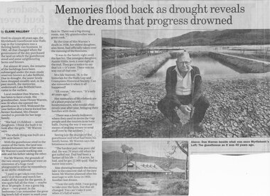
Until the closure 40 years ago, the Myrtlebank Guesthouse near Halls Gap in the Grampians was a thriving family - run business. In 1962, all that changed when the government of the day purchased the land on which the guesthouse stood and some neighbouring farms and houses. For almost 40 Years, the remains of the buildings have been submered under the man made reservoir known as Lake Bellfield. Due to drought, the eater levels have dropped steadily and, in the past month, the memories underneath Lake Bellfield have come to the surface. Local resident Don warren 70, has been to have a look. His grandmother Anne Flower Warren, was 56 when she opened the guesthouse in 1916. Widowed, the year before after a horse kicked her farmer husband, Mrs Flower needed to provide for their large family. "She had 13 children - seven daughters. I think she built it to look after the girls," Mr Warren says, "The whole think was built on a 500 acre farm." With the guesthouse sited in the centre of the farm, the land was divided between two of her sons- Mr Warren's uncle working one side and his father taking the other. For Mr Warren, the grounds of the two-storey guesthouse were an extension of a huge rural playground in what he remembers as an idyllic childhood. "I used to get taken over there and I'd sit there and watch her make all the toast for the guests. It was quite full all the time - maybe 40 or 50 people. It was a great big place - very grand. In the bedrooms I can remember the great big bowls full of water to wash your face in. There was a big dining room, too. My grandmother was a great cook." By the time of Mrs Warren's death in 1936, her eldest daughter also Anne, had officially taken over the running of the business. "It was in the family right until the last bit. The youngest daughter, Auntie Hilda, took it over right at the end. they got a notice to say that's it - it's over There was no way out of that one." Mrs Ida Stanton, 78, is the historian for the Halls Gap and Grampians Historical Society. Can she remember it when it all happened? "Of course" she says "It's only 40 years ago" Her memories of Myrtlebank are of a place popular with honeymooners, who would often return year after year, bringing their families with them. "There was a lovely ballroom where they used to invite the Gap people and the tourists in to have balls. During the war it was one means of making money to send stuff over to the soldiers." Seeing just the stumps of the guesthouse and what had been his family home, Mr Warren says the bitterness is still there. "The hardest part was poor old dad. He was 70 years old when he got turfed out. Dad had been a farmer all his life - 214 acres, he had, and he got 22,000 quid. Had to move into town" Also showing beneath the drying lake is the concrete slab of the new home Mr Warren planned after his marriage to wife Anne in 1955. Another lost dream. " I was the only child, I was going to take over the farm, but that all changed. You can't take it over when it's full of water.Newspaper clipping of history of Myrtlebank by Don Warren and photo of Don at old site of pooland guest House photo Article by Claire Halliday from newspaper 2002accommodation, guesthouses, myrtlebank -
 Bacchus Marsh & District Historical Society
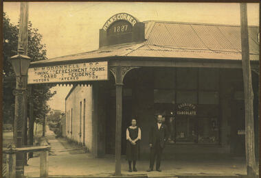
Photograph, Ryan's Corner Shop and Refreshment Rooms. 1923
This building on the corner of Main and Gell Streets, comprised of two shops, a residence and sheds at the back, was built by Jeremiah Ryan in 1886-7. It became known as "Ryan's Corner". The first usage as mentioned in the Bacchus Marsh Express was as a jewellery in one shop and a fish and oyster shop combined with Watson's agency business in the other. Over the years, a variety of businesses operated in the two shops, including a barber shop, auctioneer and land agent premises, a hairdresser, solicitor's, costumiere, and bootmaker. Joseph Burbidge operated a greengrocery on this site for several years until the corner store was purchased in 1903 and became an ABC Cafe. Various businesses continued to operate on the site, with the neighbouring ABC cafe continuing in business with a number of different proprietors. The cafe was taken over by Miss Mary O'Donnell in 1922, assisted by Mr "Bill" Day, who became a business partner in 1924. In 1935, Miss O'Donnell sold her share of the business to Mr Day, who continued to operate the tea rooms with his wife. He remained the sole proprietor until his death in 1963. Because he was a well-known shop-keeper in the town over a period of forty years, his establishment became known locally as "Bill Day's Corner". In 1968 the building was demolished for the Commonwealth Bank, which continues to operate on this site.Black and white photograph mounted on brown cardboard. Photograph of M. O'Donnell A.B.C. Refreshment Rooms with a young woman and a gentleman standing outside on the footpath. They can be identified as Virgie McCusker and W.J "Bill" Day. The corner brick building has a corrugated iron roof with a verandah supported by pillars featuring wrought iron corners. The corner pediment bears the name : Ryan's Corner 1887. The space between the corner pillars has a large sign reading: Miss M. O'Donnell. A.B.C. Dining & Refreshment Rooms. Board & Residence. Motors Catered For. The front window has an advertising sign: Cadbury's Chocolate. A sign on the door reads: Luncheon Please. Items can be seen in the window. At the corner stands an ornate iron gas lamppost.On the back: Handwritten: Corner Main & Gell Sts built by Jeremiah Ryan 1)Day. demolishe 19 (incomplete date) Site now Commonwealth Bank. C.B.A. opened 1963. Virgie McCusker, niece of Miss O'Donnell. 21/3/23.shops bacchus marsh, small businesses bacchus marsh, refreshment rooms, w.j. "bill" day 1887-1963 -
 Bendigo Historical Society Inc.
Book - LA TROBE UNIVERSITY BENDIGO COLLECTION: BENDIGO TEACHERS' COLLEGE
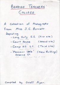
The first page of the book titled 'Photographs of Bendigo Teachers' College 1925-1971 from the collection of Miss J.C. Burnett'. The page is titled 'Bendigo Teachers' College'. It states that this book is a collection of photographs from Miss J.C. Burnett including photographs of the various sites of Bendigo Teachers' College. Long Gully S.S. (first site). Court House (second site). Camp Hill S.S. (third site) and 'Pleasant Vale' the new buildings in Osborne Street. Compiled by Geoff Pryor. See 3320.100 bendigo, education, bendigo teachers' college, miss j.c. burnett, mr. geoff pryor, history, buildings, place, tertiary education, teacher training, tertiary education -
 Bendigo Historical Society Inc.
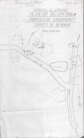
Photograph - DIAMOND HILL 1936, PLAN OF OCCUPATION
Print of 'Application of J. Hattam, plan of occupation parish of Sandhurst, County of Bendigo' Plan shows Post Office site, large dam, 'formerly cultivated site near Post Office'. A un-named gully is marked.bendigo, mining, diamond hill -
 Bendigo Historical Society Inc.
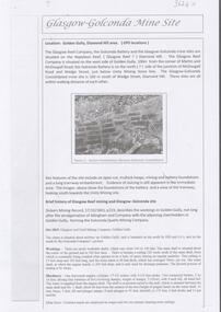
Document - GLASGOW GONCONDA MINE SITE DIAMOND HILL
Brief description of the Glasgow Golconda mine site and the Glasgow Reef mining history. The site is Glasgow Golconda mine is situated midway up Golden Gully is bounded on the north by Hill & Co's and on the south by the Golconda Company's ground.bendigo, mining, glasgow golconda -
Port Melbourne Historical & Preservation Society
Photograph - Former COR site and surrounds, Douglas Smallpage, 1960s
17 colour and Black and White transparency slides of C.O.R (BP) oil co site, sites around Station Pier. Port Melbourne library and Senior Citizens Centre in Liardet St and Trugo Club in Garden Citysport - trugo, built environment - civic, built environment - industrial, sandridge trugo club -
Whitehorse Historical Society Inc.
Article, War Memorial is home at last, 1988
Mitcham's war memorial has been moved to Halliday Park.Mitcham's war memorial has been moved to Halliday Park. This site was originally chosen for this bugler memorial. It is not known why the memorial was placed in Whitehorse Road originally. This new site allows him to face east, to the hills.Mitcham's war memorial has been moved to Halliday Park. clubs and associations, mitcham returned servicemens league, war memorials, halliday park -
University of Melbourne, Burnley Campus Archives
Plan, Proposed Stores & Garage Renovations, 1997
Burnley Development Site for Amrad Operations Pty. Ltd. By Johnston Merat Kurdiovsky Pty. Ltd. Dated March 1997. Scale 1:100. (1) Site Improvements Plan. (2) Elevations - Building & Fence Treatment.amrad, burnley, stores, garages, johnston merat kurdiovsky p/l -
 Lakes Entrance Historical Society
Photograph - TAFE site, Fish Marie, 1995
Black and white photograph of the site of Peck's fish processing factory on Bullock Island. It shows a heavy machine in background, broken concrete and rubbish skip in foreground, site cleared for TAFE education complex. Lakes Entrance Victoriaislands, education -
 Kiewa Valley Historical Society
Photograph of Pretty Valley Workers Camp*, Pretty Valley Camp, circa 1949
Erection of staff quarters at Pretty Valley was completed in April, 1947 and accommodation for construction workers commenced in 1948 but suspended on 11th May for winter and resumed on 9th November. Construction of this camp was completed in 1949. A large dam was proposed at this site but was never constructed. Instead a small diversion dam was built which diverts water either to Rocky Valley Dam or to McKay Creek Power Station.An historical record of the type of accommodation provided for workmen during the construction of the Kiewa Hydro Scheme during the 1940's/50's.A black and white photograph of Pretty Valley Camp, c 1949. Dead trees are in the foreground, on both the left and right side of the photograph and a small snow gum is evident. There are camp huts and a much larger building behind these, possibly a workshop, and power poles are evident bringing electricity to the site.Handwritten in blue ink on back of photograph "Pretty Valley Camp. 5600 ft. above sea level".pretty valley, dam, water, workmen, camp -
 Ringwood and District Historical Society
Photograph, Ringwood State School - Rear of Schoolmasters house, Ringwood, 1945
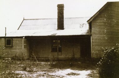
Black and white photograph "Notes attached to photograph" 1945- Rear of Schoolmasters house. Former Nunawading School No 2242. Removed from it's site in Heatherdale on March 18th, 1892 to a site near the corner of Ringwood Street and Civic Place. -
 Ballarat Heritage Services
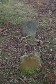
Photograph - Colour, Grave at Vaughan Chinese Cemetery, 2017, 16/07/2017
This site was used as a burial ground from 1855 (about) to 1859. European and Chinese pioneers rest here. The Bendigo Chinese Society Honouring the memory of their Countrymen, fenced the site, 1928 Population of Vaughan 1859, 13000vaughan, vaughan springs, vaughan chinese cemetery, chinese -
 Ballarat Heritage Services
Photograph - Colour, Grave at Vaughan Chinese Cemetery, 2017, 16/07/2017
This site was used as a burial ground from 1855 (about) to 1859. European and Chinese pioneers rest here. The Bendigo Chinese Society Honouring the memory of their Countrymen, fenced the site, 1928 Population of Vaughan 1859, 13000vaughan, vaughan springs, vaughan chinese cemetery, chinese, thomas eynon -
 Ballarat Heritage Services
Pamphlet - Photograph - Colour, Grave at Vaughan Chinese Cemetery, 2017, 16/07/2017
This site was used as a burial ground from 1855 (about) to 1859. European and Chinese pioneers rest here. The Bendigo Chinese Society Honouring the memory of their Countrymen, fenced the site, 1928 Population of Vaughan 1859, 13000vaughan, vaughan springs, vaughan chinese cemetery, chinese, thomas eynon -
 Ballarat Heritage Services
Photograph - Colour, Grave at Vaughan Chinese Cemetery, 2017, 16/07/2017
This site was used as a burial ground from 1855 (about) to 1859. European and Chinese pioneers rest here. The Bendigo Chinese Society Honouring the memory of their Countrymen, fenced the site, 1928 Population of Vaughan 1859, 13000vaughan, vaughan springs, vaughan chinese cemetery, chinese, thomas eynon -
 Ballarat Heritage Services
Photograph - Colour, House Near Vaughan Chinese Cemetery, 2017, 16/07/2017
This site was used as a burial ground from 1855 (about) to 1859. European and Chinese pioneers rest here. The Bendigo Chinese Society Honouring the memory of their Countrymen, fenced the site, 1928 Population of Vaughan 1859, 13000vaughan, vaughan springs, vaughan chinese cemetery, chinese, thomas eynon -
 Ringwood and District Historical Society
Photograph, Maroondah Highway East, Ringwood- 1969. Burnt Bridge Shopping Centre, cnr Maroondah Hwy and Beaufort Road
Black and white photographWritten on back of photograph: "Site of Burnt Bridge Hotel - (later a store). Nov 1969." -
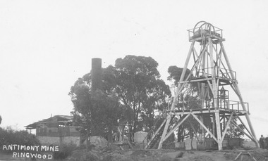 Ringwood and District Historical Society
Photograph, Antimony Mine, Ringwood 1920
Typed below photograph, "Antimony Mine, Ringwood (Now Civic Centre site). 1920". -
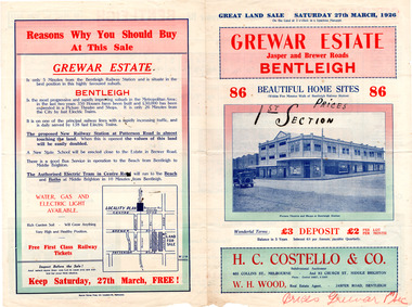 City of Moorabbin Historical Society (Operating the Box Cottage Museum)
Flyer - Grewar Estate, Bentleigh, 1st Section Sold at Auction, 1926
The train line from the city to Frankston was electrified which intensified the sale in the municipality of Moorabbin, particularly land which was in the vicinity of the railway stations.Example of the progress of the Municipality of MoorabbinAdvertising flyer for auction of real estate sales - plan of building blocks for saleGrewar Estate Bentleigh - 86 Home Sites - H.C. Costello & W. H. Woodpatterson road, jasper road, bentleigh, real estate, auction, grewar -
 City of Moorabbin Historical Society (Operating the Box Cottage Museum)
Flyer - Grewar Estate, Bentleigh, 2nd Section Sold at Auction, 1926
The train line from the city to Frankston was electrified which intensified the sale in the municipality of Moorabbin, particularly land which was in the vicinity of the railway stations.Example of the progress of the Municipality of MoorabbinAdvertising flyer for auction of real estate sales - plan of building blocks for saleGrewar Estate Bentleigh - 73 Home Sites - H.C. Costello & W. H. Woodbentleigh, real estate, auction, grewar, mitchell street, daley street, brewer road -
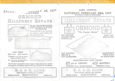 City of Moorabbin Historical Society (Operating the Box Cottage Museum)
Flyer - Hillcrest Estate, Ormond, 1927
The train line from the city to Frankston was electrified in 1922 which intensified the sale in the municipality of Moorabbin, particularly land which was in the vicinity of the railway stations.Example of the progress of the Municipality of MoorabbinPhotocopy of advertising flyer for auction of real estate sales - plan of building blocks for saleHillcrest Estate, Ormond - 26 Home sites for auction Saturday 26 February 1927.parker street, holloway street, wild cherry road, wallen road, florence street, wimmera street, leila road, real estate, ormond, auction -
Clunes Museum
Book, PINNACLE PRINTING CO. PTY.LTD, VICTORIA 150 YEARS OF GOLD, 2001
VICTORIA 150 YEARS OF GOLD HISTORYGOLD COVERED BOOK - VICTORIA 150 YEARS OF GOLDnon-fictionVICTORIA 150 YEARS OF GOLD HISTORYlocal history, document, book, gold, mining, gold, mining, history -
 Ringwood and District Historical Society
Photograph, Maroondah Highway Central, Ringwood. View of Loughnan's hill taken from Ringwood oval. c1960's
Black and white photographWritten on back of photograph: "Loughnan Hill from Eastland site - 22/6/67". -
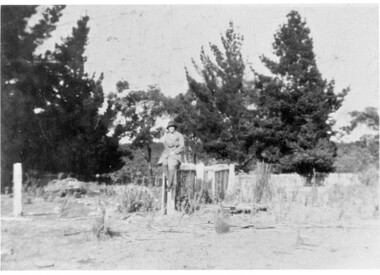 Linton and District Historical Society Inc
Photograph, Eva Simper
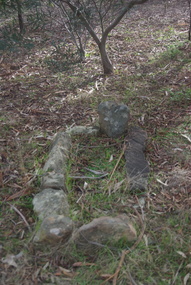
Black and white photograph of a woman wearing a hat sitting on top of a fence in distance."Eva Simper sitting on top of fence near well at Simpers old home site"eva simper -
 Kiewa Valley Historical Society
Photograph - Folder of Photographs (KVHS 1150 A - F) – Photocopied set of black and white photographs from the display folder (pages 1 - 8) put together by KVHS to document life on the Kiewa Valley Hydro-electric Scheme
Although the Kiewa Hydro-Electric Scheme was first proposed in 1911, construction did not commence until 1938. As part of the push to cut electricity costs and diversify supply, the Victorian Government (circa 1930) initiated the conversion from primarily brown coal supply to hydro – electricity. Field investigations during the 1940’s resulted in a new proposal for a scheme that had more than double the capacity of the 1938 scheme. The Kiewa Hydroelectric Scheme became the largest scheme of its kind in the State Of Victoria and the second largest scheme in Australia. The number of personnel involved in the planning and construction of the scheme increased dramatically. During the late 1940’s, most activity centred around the construction of the West Kiewa Power Station, Rocky Valley Reservoir, McKay Creek Power Station and the Bogong Creek Aqueduct.A common thread across all the larger hydro scheme constructions was the need for workers, both qualified and unqualified who came from around the world seeking a new life for themselves and their families. New accommodation and facilities were required for the army of workers engaged in construction in often remote and wild areas. The SEC had a high demand for timber, and set up the first of a number of sawmills at Bogong Creek in 1939 and set up the first hardwood logging in the headwaters of the Kiewa River. These new ‘towns’ such as Mt Beauty and Bogong, survived, serving the needs of operational personnel and their families, and expanding with growth of new industries. Mount Beauty, and to a lesser extent Bogong, are among these places. Large A3 size spiral bound display folder containing 21 of 58 pages of photocopied black and white photographs of various aspects of the early days of the Kiewa Valley Hydro-electric scheme including equipment, various work sites and photographs of workers and their families. 1-Front page; 2-Security gate at Mt Beauty Camp; 3-Channel 1 on East Kiewa River; 4-Junction Dam – Diversion Tunnel Inlet; 5-Sawmill; 6- Homan’s Gap Sawmill; 7 Junction Dam: 8-Homan Dam Site-Diamond Drilling on River Buttress; 9- Homan Dam Site View Upstream 10-Homan Dam Investigation Camp 1-Windsor & Newton Visual Diary 60 sheet (120 pages) 11’ x 14’ 280 x 356mm 110 GSM Acid Free Drawing Paper 2-1940-Security Gate on Mt Beauty side of Kiewa River bridge. Part of old Mt Beauty camp and mess in background 3- STATE ELECTRICITY COMMISSION OF VICTORIA Date; 11.3.40 Time: 10.30am No K35 Kiewa Hydro Electric Works. Diverting East Kiewa River into Channel Page number 1 4-STATE ELECTRICITY COMMISSION OF VICTORIA Date: 5.4.40 Time: Noon No K58 Kiewa Hydro Electric Works. Junction Dam – Diversion Tunnel Inlet – Normal Flow Page number 2 5- STATE ELECTRICITY COMMISSION OF VICTORIA Date: 19.8.42 Time: 2.30pm No K883 Kiewa Hydro Electric Works. Sawmill – General View Page number 3 6- STATE ELECTRICITY COMMISSION OF VICTORIA Date: 12.1.42 Time: 2.00pm No K540 Kiewa Hydro Electric Works. Homan’s Gap Sawmill – General View Page number 4 7- STATE ELECTRICITY COMMISSION OF VICTORIA Date: 12.1.42 Time: 2.00pm No K540 Kiewa Hydro Electric Works. Junction Dam – General View looking upstream Page number 5 8- STATE ELECTRICITY COMMISSION OF VICTORIA Date: 16.11.45 Time: 10.32amm No K52153 Kiewa Hydro Electric Works Homan Dam Site – Diamond Drilling on River Buttress Page number 6 9-STATE ELECTRICITY COMMISSION OF VICTORIA Date: 15.1.45 Time: 4.10pm No K1781 Kiewa Hydro Electric Works Homan Dam Site – View Upstream Page number 7 10- STATE ELECTRICITY COMMISSION OF VICTORIA Date: 15.1.45 Time: 4.10pm No K1781 Kiewa Hydro Electric Works Homan Dam Investigation Camp 1944 – 1945 Page number 8 secv; kiewa hydro electric scheme; mt beauty; bogong; construction work;