Showing 1556 items
matching storey
-
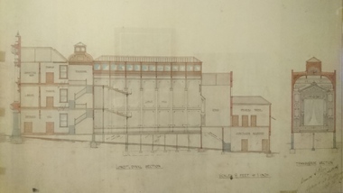 Unions Ballarat
Plan - Photograph: Trades Hall building architects' design, 1886
Original architects' drawings for the construction of Trades Hall, Ballarat. November 5th 1886 the building committee called for tenders for the erection of a Trades Hall on the following conditions. The amount to be expended to be no more than £3,000; bluestone foundations; the front of the building to be of Grampians freestone and walls of brick. Building to be 3 storeys high, containing 14 rooms with a hall capable of seating 600 persons, roof to be of slate and workmanship and material to be of the best quality. The design submitted by Messrs James and Piper was accepted subject to amendment.Relevance to the history of Trades Hall, Ballarat.Paper - architects' plans.btlc, ballarat regional trades and labour council, ballarat trades and labour council, ballarat trades hall, eight hours anniversary committee, james and piper, architects' drawings, building -
 Surrey Hills Historical Society Collection
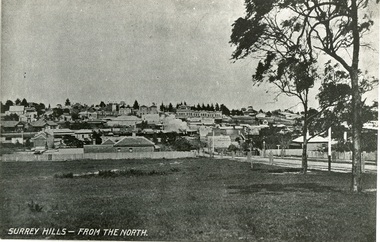
Photograph, Surrey Hills from north of Montrose Street 1907-1911
In the foreground is Dr Blakie's first surgery, later the Police Station, then a Service station. Behind and to the left are the two railway station buildings. On the horizon and in front of the pine trees is 'Montalto', home of the Hansen family, later Dr Box (demolished). Two storey terrace of shops in front of this is Hansen's Terrace. In centre, note smoke from steam train. On corner of Guildford Rd is a Gas Lamp. The first trees have been planted in Union Road and are protected with stout wood surround.Black and white photograph of a view of Surrey Hills. Written on the bottom left hand side "SURREY HILLS - FROM THE NORTH". In the foreground are two trees on the right hand side before a view leading up the hill. dr blakie, police station, hansen terrace, dr box, montalto, guildford rd, gas lamp, union road -
 Eltham District Historical Society Inc
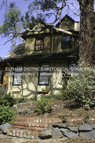
Photograph - Digital Photograph, Alan King, Langi Dorn, Fay Street, Eltham, 29 January 2008
Langi Dorn, Fay Street. This house is reminiscent of ‘ye olde’ England, with its steep-pitched gabled roof. The rectangular single storey building with two attics has a warm atmosphere, created in part by the extensive use of timber in walls and floors. Some walls are framed in timbers as in the English Tudor style. Covered under Heritage Overlay, Nillumbik Planning Scheme. Published: Nillumbik Now and Then / Marguerite Marshall 2008; photographs Alan King with Marguerite Marshall.; p151This collection of almost 130 photos about places and people within the Shire of Nillumbik, an urban and rural municipality in Melbourne's north, contributes to an understanding of the history of the Shire. Published in 2008 immediately prior to the Black Saturday bushfires of February 7, 2009, it documents sites that were impacted, and in some cases destroyed by the fires. It includes photographs taken especially for the publication, creating a unique time capsule representing the Shire in the early 21st century. It remains the most recent comprehenesive publication devoted to the Shire's history connecting local residents to the past. nillumbik now and then (marshall-king) collection, eltham, fay street, john harcourt, langi dorn -
 The Beechworth Burke Museum
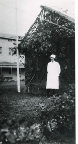
Photograph - Photograph Reproduction, 1998
The photograph, created in 1998, is a copy of the original one, depicting a nurse in uniform at the Mental Hospital in Beechworth, with a fern house behind her. In the background, the two-storey building is in view, along with the covered walkway. The institution had to operate with serious shortage of female nurses for long periods of time. During the 1880s, small houses (cottages) were built to offer accommodation for the nurses living in the hospital and in 1937 began the construction of a nurses` hostel. In 1962 the upper level of the Nurses` Home was converted into a Nurses` Training School. The Mayday Hills Hospital was constructed between 1864 and 1867, with buildings created in a number of periods. It formally opened on 24 October 1867 and, along with the Ovens Hospital and the Benevolent Asylum, made Beechworth a prominent social welfare centre in Victoria. The need for an institution of this kind was arisen due to the increased number of people with mental disturbances (induced by the harsh living conditions on the goldfields) and the remoteness of the district from Melbourne. The two-storey buildings, designed in Italianate style, and the three-storey towers at the front, were influenced by the asylum at Colney Hatch in England. Large masses of granite were excavated for its foundation and around 250 workmen were employed for its construction. The building, divided into six sections, was comprised of dormitories, doctors` rooms and plenty ancillary rooms and facilities, such as laundries, reading rooms, a concert hall and cooking areas. The site was chosen for its panoramic view of the countryside, the hilltop atmosphere and the native fauna, all contributing to the cure of patients. The Hospital was originally named the “Ovens Lunatic Asylum” but, during the centenary celebrations in 1967, the name was officially changed to “Mayday Hills Hospital”, showing the gradual shift in the perception and understanding of mental health conditions over the last decades. The Hospital lies on the traditional land of the Kulin Nation.This photograph is historically significant as it provides an insight into the everyday life of staff living within the walls of the Mayday Hills Hospital. It also offers important information about the location and the exterior of the Hospital and contributes to the understanding of the district`s development and its importance to the course of Victoria`s history.Black and white rectangular photograph printed on paper unframed.Reverse: 3445/mental hospital, beechworth, fern house, female nurses, nurses` home, nurses` training school, nurses` hostel, mayday hills hospital, ovens hospital, colney hatch, two-storey buildings, italianate style, benevolent asylum, ovens lunatic asylum, kulin nation, workmen, covered walkway, granite, hilltop atmosphere, mental health -
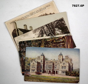 Bendigo Military Museum
Postcard - POSTCARD, VARIOUS, cWW1
Each postcard features handwritten anecdotes and letters to various people in R.H. Baron's family. Baron was a band member. Part of the "Robert H. Baron" (No. 3596) and Cooper Collections. See Catalogue No. 1981P for details of Baron's service.1. Coloured drawing of a Stately house with motor car, people and a horse in foreground. 2. Coloured drawing of a couple walking through an avenue of trees. 3. Black and white photograph of a church with square tower. 4. Coloured photograph of a mill building and adjacent body of water. 5. Black and white photograph of a row of buildings fronting an unsealed road. 6. Sepia toned photograph of a large stately three storey house.1. Handwritten in black ink on back: 'Letter to Doris written by R.H. Baron - dated 14 July 1918'. Picturesque, Wiltshire, Charlton House, near Malmsbury. 2. Picturesque Wiltshire Avenue, Savernake Forest. Handwritten in black ink on back: 'Letter to R.H. Baron's sisters and brothers.' 3. St. Mary's Church, Motcombe, Dorset. Handwritten in black ink on back: 'We played at a service at this church last Sunday night (1/12/18), Bob xxx' 4. Worplesdan, Rickford Mill, Handwritten in black ink on back: ' Letter to Alf from R.H. Baron.' 5. Crown Inn, etc. Hartley Row. Handwritten in black ink on back. 'Anecdote signed by Bob (R.H. Baron)'. 6. Longleat House. Handwritten in black ink on back; 'We were playing at a dance at this place a few weeks ago. We had a splendid time. It is near Bath, Bob'.robert h. baron, cooper collection, postcards, ww1 -
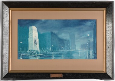 Glenelg Shire Council Cultural Collection
Print - Print (reproduction), Will Longstaff, The Immortal Shrine, n.d
CEMA Art collection Previously located in History HouseThe print depicts a night view of a city street. In the foreground are ghosly figures completing a military march along a wide street. On the left side is a large white Remembrance Shrine with three flags hanging on individual flagpoles. In the background are numerous multi-storey buildings with a row of light streetlights in front. The work is completed in various shades of blue and mounted with brown card. Framed with a gold and black frame, the work has an exposed canvas.Front: Brass embossed plate: THE IMMORTAL SHRINE BY WILL LONGSTAFF COPYRIGHT REGISTERED Back: (No inscriptions) -
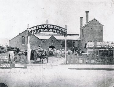 Bendigo Historical Society Inc.
Photograph - NORFOLK BREWER: SAYER BROS, 1861
Black and white photo: Norfolk Brewery, Sayer Bros. on sign over entrance, brick industrial building with 2 storeys at right with 2 chimneys, 2 gables with louvred arched openings. Weatherboard building with bark roof at right. Stacks of wood at left. Picket fence at front. Horse drawn vehicles in yard. Batchelder photogapher cart at front left, cart with barrels in gateway. Gateway with sign and barrels above,.Batchelderbuildings, commercial, norfolk brewery -
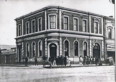 Bendigo Historical Society Inc.
Photograph - BANK OF AUSTRALASIA, 1860's
black and white copy: Bank of Australasia building, corner of Pall Mall and Williamson St., Photographer's handcart in picture. Two storey brick building, arched windows to ground floor, rectangular windows above. Above corner doorway is a coat of arms, similar in shape to present City of Melbourne coats of arms. In image on verandah ' J. Holdsworth./Chemist ' Bank of Australasia/ House, Assay office. On back in grey lead '10'Batchelderbuildings, bank, bank of australasia -
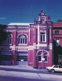 Bendigo Historical Society Inc.
Photograph - BENDIGO FIRE STATION, 1980's ?
Colour photo : two storey red brick building, corrugated iron roof. Concrete balustrade, finials and pediment to roof line. N Arched windows with decorative surround. Rectangular windows with decoration at top. Two lift up doors at left - appear to be later addition or alterations. White sedan at front fight. In image above lift up doors ' Fire Station' J. Lerk 28.2.2000 ' Bendigo Fire Station 'buildings, government, fire station -
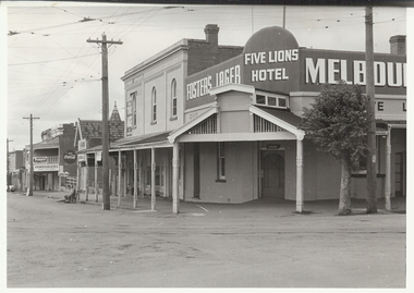 Bendigo Historical Society Inc.
Photograph - FIVE LIONS HOTEL: BENDIGO, 1950/60's
Black and white photograph. Not mounted. Five Lions Hotel,Cnr View and Barnard Streets, Bendigo. Tram lines with overhead cables. 2 men on seat on left of photo. Fosters Lager sign on left with Five Lions Hotel over corner. 2 double storey shops, one next to hotel appears empty, faint name of business ??/ pastrycook. On back ' Five Lions Hotel, cnr. Barnard and View Sts. 'Alan Doney ??organization, business, five lions hotel -
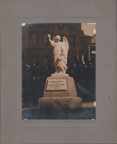 Bendigo Historical Society Inc.
Photograph - FOSTER AND WILSON COLLECTION: PHOTOGRAPH, 1925
Dark sepia? photo of a statue of a small girl with an angel standing beside her. The angel has the right hand raised. The statue is mounted on a large shaped piece of granite. It has a plaque with: Jubilee Gift of the Catholic Railway Men of Bendigo 1925. A large 3 storey brick building is in the background and also a crowd of people. Photo is mounted on grey cardboard. Written on the back: 'To Mr S. McKinnon with Dean Rooney's Compliments.'photograph, bendigo, foster & wilson collection, photograph, mr s mckinnon, dean rooney, catholic railway men of bendigo -
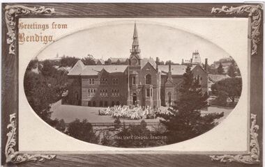 Bendigo Historical Society Inc.
Postcard - CARWARDINE COLLECTION: CENTRAL STATE SCHOOL BENDIGO
Sepia colour postcard, brown frame, image enclosed in oval shape. Image shows Central State School Bendigo ( now Camp Hill). Two storey building, spire. Children assembled in front of building. Image taken from Rosalind Park looking towards Hustler's Hill. Poppet head visible in back right. Top left corner are the words ''Greetings from Bendigo''. Receipt number 355/16Bendigo C & L Seriesbendigo, business, carwardine soap and candle -
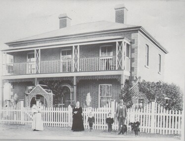
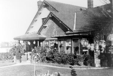 Surrey Hills Historical Society Collection
Photograph, Home and surgery of Dr William Langley Carrington, 174 Union Road, 1935
The building was erected in c 1913 as a home / surgery for Dr James L Blakie (1868-1937), who originally lived / practised across the road. It was designed by architect Arthur William Plaisted (1890-1965) and is an early example of attic-style Californian bungalow style. Dr Carrington ( 1900-1970) succeeded Dr Blakie and practised at 174 Union Road from 1930-1970. Now known as the Surrey Hills Medical Centre.Black and white photo of the surgery and home of Dr and Mrs William Langley Carrington at 174 Union Road on the corner of Guildford Road, Surrey Hills.. The exterior of the building is decorated with paper lanterns around the windows and veranda for the Empire Day celebrations in 1935. The building is 2 storey, of brick construction with a tiled roof and front porch. It has a bay window front right. Shadows indicate the photo was taken early morning in winter.medical services, guildford road, union road, dr william langley carrington, mr arthur plaisted, dr james landells blakie, californian bungalow, dr bill carrington -
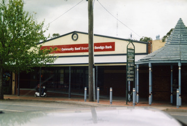 Charlton Golden Grains Museum Inc
Photograph, Bendigo Bank, High St Charlton c. 2002
Bendigo Bank built on land formerly occupied by Clark's Butcher Shop. Branch opened in 2003.Colour photograph of Bendigo Bank building. Single storey brick building. Signage is partially obscured by tree and reads 2003 Charlton & District Community Bank Branch Bendigo Bank. Blue timber covered entrance to the Traveller's Rest complex on the RH side. Person going past on mobility scooter. Green signage for Traveller's Rest reads CAFES BAKERY PUBLIC TOILET CHEMIST HOTELS MOTELS SUPERMARKETS NEWSAGENCY.charlton, bendigo bank, business, industry, clark's butcher -
 Kew Historical Society Inc
Slide - Rear of Villa Alba with adjacent hospital wing, 1987–2001
Built for William and Anna-Maria Greenlaw in the early 1880s, and with interiors decorated by the Paterson Bros, Villa Alba remained in private ownership until 1949. From 1950, the house was owned by a number of institutions. By 1984, the Villa Alba Preservation Society had been formed, and three years later, the Mount Royal Hospital granted a 25-year lease to Kew Council. In 2004, the title to Villa Alba was passed by the Victorian Government to The Villa Alba Museum Incorporated. Digital copy of a olour 35mm slide, framed in a plastic mount, of the portico of Villa Alba, 44 Walmer Street, Kew, 3101. The transparency shows the grey rendered rear of the building, viewed from the east, looking west. A two storey wing of the Mount Royal Hospital, facing Nolan Avenue is at the right. The slide shows a set of wire gates separating the east garden of Villa Alba from the main house."Villa Alba"villa alba museum, mount royal hospital, historic houses -- kew (vic.), victorian architecture -- melbourne (vic.) -
![Painting: Park Street [Adeney Avenue] Kew](/media/collectors/550653872162f11fb04854aa/items/5826877cd0cdd11284ad5413/item-media/614ac683a53a0756fd5e49da/item-fit-380x285.jpg) Kew Historical Society Inc
Kew Historical Society IncPainting, Park Street [Adeney Avenue] Kew, c. 1896
‘Adeney Avenue’ was the title given to this painting following its donation to the Kew Historical Society, yet the work’s origins predate the naming of Adeney Avenue in 1907 [originally gazetted as ‘Park Street’ (1865) and ‘Park Street South’ (1875).] Park Street ran between High Street and Parkhill Road beside what was later to become ‘Victoria Park’. This area was described in 1851 as “…a dense forest of gums and wattles which were to be largely cleared by 1888 after the naming of a recreation reserve”. The Reserve was still bisected by an unnamed creek in 1896, when the area was surveyed by the MMBW. The panoramic vista selected by the artist would appear to include ‘Eborensis’ (c.1895) on the corner of Parkhill Road and what was then Park Street, with views across cleared land towards the distant ranges. In the 19th century, north Kew was largely undeveloped farms stretching down to the Yarra. Oil on canvas by an unidentified artist of a panoramic view depicting what is now known as East Kew with mountains on the horizon. In the foreground is a two storey brick residence - Eborensis - located on the northeast corner of Parkhill Road and what is now Adeney Avenue. The view of the landscape and its rolling hills resulted from farming practices adopted following colonisation and settlement. Trees in the foreground and in the distance include remnant Eucalypts and introduced exotics.Label on rear of frame states "House on corner of Adeney Ave & Parkhill. [Regd. 254"]. Otherwise unsigned and undatedadeney avenue (kew), eborensis, park street (kew) -
 Melbourne Tram Museum
Document - List, "Melbourne Transport - Day by Day Year by Year", c1996
Nineteen page list of events in Melbourne Transport, in date order and then year order, titled "Melbourne Transport - Day by Day Year by Year". Has been photocopied onto A4 paper. Has dates out to 1995. Format has similarities to the "Timeline history of Melbourne's Government Cable and Electric Trams and Buses" by Barry George, Don Storey John Birch et al. Possibly produced for a tram tour.trams, tramways, mmtb, mto co, opening, melbourne, lists -
 Flagstaff Hill Maritime Museum and Village
Photograph - Historical, maritime, Brookes' Photographic Union, Harbour Works, Warrnambool, 1891
This photograph records the making and placing of the concrete blocks for the construction of the Warrnambool Breakwater in the Warrnambool Harbour, completed in 1890. Each block weighed 20 to 30-plus tons. The huge Titan steam powered crane in the photograph played a massive role in the construction. It was able to lift the concrete blocks with its overhanging, counterbalanced arm and roll on its wheels along the rails to the required position. It then lowered the blocks into position on the concrete foundation already laid on the seabed. There are many details in the photograph that help to tell other aspects of Warrnambool's history. It appears that the photograph was once owned by B. Fisher. The photograph is part of the Western Victoria collection produced in 1891 by Brookes' Photographic Union in Victoria. Brookes' Photographic Union was a collaboration of two brothers, Frederick Augustus Brookes and his brother Albert Edward Brookes. Frederick arrived in Victoria in the early 1880's. He and Albert formed the organisation to produce collections of photographs including the districts of Geelong, Gippsland and the Western Victoria.This photograph was taken during the construction of the Warrnambool Breakwater and published the year after it was completed. The project began with the Government of 1874 approving the plan, and was completed in 1890. The image records a snapshot of the construction of the Warrnambool Breakwater, a construction that changed the history of the Port of Warrnambool, Photograph, sepia coloured rectangular shape, mounted between two sheets of cream card. Border of photograph is decorated with pen lines and design in corners. Subject is the Warrnambool Breakwater construction with the Titan steam crane on rail lines, concrete blocks, a windmill and tanks, sheds, and a multi-storey building in the background. Produced by the Brookes' Photographic Union, Western Victoria. Inscriptions are on the reverse, on two stickers, a printed white label and a handwritten name.Stickers: "137" "F.Pn 61/2-74" Label: "WESTERN VICTORIA / BROOKES' PHOTOGRAPHIC UNION / HARBOUR WORKS, / WARRNAMBOOL." "The subject of this picture is the making of concrete blocks for the Breakwater. These blocks weigh from 20 to 30 tons each, and are lifted about by the large piece of machinery seen in the picture." Hand written: "B. Fisher"flagstaff hill, flagstaff hill maritime museum and village, warrnambool, maritime museum, maritime village, great ocean road, shipwreck coast, western district, western victoria, brookes' photographic union, frederick brookes, albert brookes, photograph, warrnambool harbour, harbour works, concrete bolcks, breakwater, warrnambool history, breakwater history, 1891, lady bay, port of warrnambool, b. fisher, titan crane, steam crane, concrete blocks -
 Bendigo Historical Society Inc.
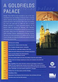
Document - BENDIGO TOWN HALL ''A GOLDFIELD' PALACE'' LEAFLET, 2002
Bendigo Town Hall, Heritage Victoria ''A Goldfields Palace Blue Leaflet'' with coloured photographs and white text. Photographs courtesy of Westox Pty Ltd and the City of Greater Bendigo. 2002. Front page features the extensive work that would be undertaken for the restoration. A time line beginning 1851, gold discovered in Bendigo. 1854 German-born W. C. Vahland arrived in the colony. 1855 Town of Sandhurst (Bendigo) became a municipality. 1856 First Town Hall was a small timber building on View point. 1857 Vahland sets up his architectural practice with Robert Getzschmann. 1859 A new, two-storey Italianate Town hall designed by George Fletcher, Town Surveyor, was built. 1866-77 Two-storey extension added to the north of the building to house the council chamber. 1871-72 Addition of the Corn Exchange comprising two storeys and a basement to the north of the building. 1878-87 Major remodelling of the exterior and interior carried out to the designs of architect W. C. Vahland. The work comprised major extensions and the addition of three towers and mansard roof, reconstruction of the main stair, decorative plasterwork by Otto Waschatz (decorated Royal palace, Copenhagen), and council chamber painted by W. J. Straugher. 1902 Painting of the main hall by Coulter and Smith of Bendigo. 1913-15 Remodelling of offices. 1926 Replacement of main Hargreaves Street hall entrance, foyer and balcony with stage. 2000 Restoration works to the Town hall commence. The middle pages and the back show some of the conservation works that were required.bendigo, tourism, town hall restoration, 4-2000 www.heritage.vic.gov.au -
 Bendigo Historical Society Inc.
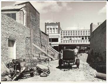
Photograph - BENDIGO ARCADE, c1950
Black and white photograph. Demolition site, taken from Old Bennett's Arcade. Brick walls each side, wheelbarrows and machinery on site. Opposite 2 & 3 storey buildings with shops and offices. In image F & E Stillwell, Furniture Warehouse. On windows 'Pitson Bros', GH? Pitson, GJ? Pitson, Public Accountants, Estate Agents, Travel Agents, Sister McKenzie, Chiropodist. Identified by James Lerk as a Alan Doney photo.Alan Doney Photoplace, arcade, bendigo arcade -
 Bendigo Historical Society Inc.
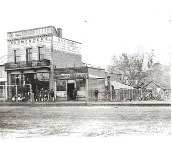
Photograph - H & C. HOLMES: IRONMONGERS, 1860's
Black and white photo, reprint of Batchelder photo. Two storey brick building ' Holmes' cast in concrete parapet. Iron lace trim on balcony. Holmes Ironmonger, Agricultural Implements, oils, paints and paper hangings painted on side. Building in McCrae Sreet. Small weatherboard building with ' Bendigo Rifle Gallery - W. Callaghan. Brooms, pans, pans in front of shop boardwalk, Ploughs to right of photo. 4 male figures present.Batchelderbuildings, commercial, h & c. holmes, ironmongers -
 Bendigo Historical Society Inc.
Photograph - HARRY BIGGS COLLECTION: ARK HALL
Photograph (proof 59) of Ark Hall, at the corner of the Calder Alternate Highway and Boyles Lane, Lockwood South. A brick two storey house, with an upstairs verandah running the full length of the house. There is a white picket fence in front of the house, Posing in front of the fence are two adult women, one holding an infant also there is a dog sitting in front of the male along with three small children. There is decorative iron lacework on the downstairs section of the verandah.buildings, house, ark hall, ark hall, boyles lane, lockwood south -
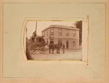 Linton and District Historical Society Inc
Photograph, Cobb & Co Coach Outside the Royal Standard Hotel, Linton
This image was copied in 2020 from a facebook post by Marcia Penny, a descendant of Linton's Craine family. Information with the image on facebook said the original photograph had been in a McIntyre family album (the McIntyre family was connected to the Craine family by marriage).Digital copy of an original photograph and its mounting card, which shows a coach drawn by two horses. The sign on the side of the coach reads "Cobb & Co / PLANET / Royal Mail". A man is standing near the horses' heads, and two (three?) other men are seated on the outside of the coach. In the background is the Royal Standard Hotel, a two-storey weatherboard building which stood on the corner of Sussex and Clyde Streets in Linton (demolished 1926). The photograph is undated.cobb & co coach, royal standard hotel, buildings, hotels -
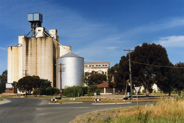 Charlton Golden Grains Museum Inc
Photograph, Charlton Shire, Charlton Flour Mill, c.1987
A previous mill had operated in Charlton by Mr. W.E. Foreman on the banks of the Avoca River and was acquired in 1919 by Noske Bros. The present Flour Mill was built by Noske Bros and opened in May 1927. It was taken over by the Grain Elevator Board in the 1970s. Colour photograph of Charlton Flour Mill and silos. Intersection of Kaye & Davies Streets in the foreground. One large silver silo and three taller greyish concrete silos to the left. Three other cream coloured silos behind. There are pipes and sheds on top of the silos. There is a cream single story building to the right of the silver silo and a multi-storey building behind with eight window in the upper level. There is a small red brick building on the far left of the photo.w.e. foreman, noske bros, flour mill charlton, business, industry -
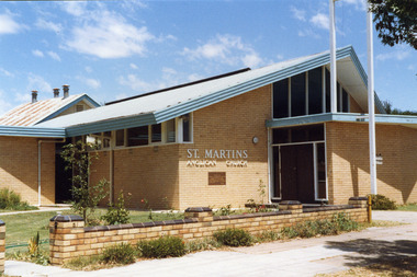 Charlton Golden Grains Museum Inc
Photograph, Charlton Shire, St Martin's Anglican Church c. 1989, c.1989
The current St Martins Anglican Church was built in 1963 to replace the first weatherboard church built in 1889. Shire of Charlton photo c. 1989.Colour photo of St Martins Anglican Church. White brick single storey building with an iron roof and blue fascia trim. There is a dark coloured double door with windows on either side and above it. There are large clerestory windows on the front and side of the building. A low pale brick fence capped with darker brick runs beside the footpath. An older weatherboard building with a rusty iron roof is partially visible behind the main church building. st martin's anglican church, church, angllican, pastoral care -
 Bendigo Historical Society Inc.
Newspaper - AUSTIN COLLECTION: Koch's Pioneer Gold Mine, Long Gully
Koch's Pioneer Quartz Mining and Crushing Company was officially registered on June 30th., 1871 (Government Gazette No. 45, 1871). It operated at Long Gully, the first Manager was Andrew Lewis. Nominal capital was 90,000 pounds in thirty thousand shares of 3 pounds each. The initial partnership in a quartz crushing plant between Henry Koch, Simon Albert and Charles Wallin was dissolved in 1860 with Koch becoming the sole owner. In 1866 the crushing plant consisted of a 50 hp engine and 48 stamping heads capable of crushing 600 tons of quartz per week. By 1902 there were 72 stamps and this was by far the largest crushing plant in the area, serving many quartz mines. Henry Koch (1800-1889) was a German sailor who signed off when his ship reached Melbourne in 1851. Having heard of the gold discovery he proceeded to Bendigo where he was initially employed in puddling in the Myers Flat area. He was soon employed and then made partner in a quartz crushing plant that he became sole owner of in 1860. He was also landlord at the British and American Hotel and the Silver Mines Hotel. HE also started the Perseverance United gold claim. He married Anna Maria Theresia Heinz in 1857. In 1872 he sold the crushing plant for 75,000 pounds and took his family back to Germany. He resumed his trade as a ship builder although he maintained many Bendigo mining interests.Two sepia coloured images on paper, possibly taken from book. Top image: Koch's 'Pioneer' Quartz Crushing Works - Long Gully, printed under image. Image shows mining dam in foreground, large two storey mine building in middle background, two mine chimney on right hand side. Bottom image; interior of crushing battery. Printed on bottom ' Quartz Crushing Batteries & etc. Koch's Pioneer'. gold mining, koch's pioneer crushing battery, long gully, perseverance g.m. co., henry koch -
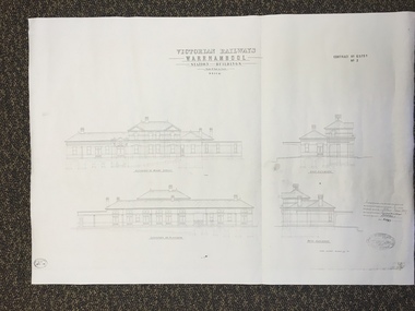 Warrnambool and District Historical Society Inc.
Map, Victorian Railway W'bool No1 & No2, 1897
These two sheets show the 1897 plans drawn up by the Victorian Railways for the erection of the Warrnambool Railway Station building. It is a two-storey building still existing today. The railway came to Warrnambool in 1890 and they must have used temporary buildings for seven years before this railway building was erected. It had offices, booking counter and public facilities on the ground floor and housing for the Station Master on the first floor. The building erected was a typical design for country town railway stations and many of similar design were erected in the 1880s and 90s. These plans are important because they show clearly the design of the Warrnambool Railway Station buildings when they were first erected in the 1890s.They will be very useful for researchers. The coming of the railway was a significant event in Warrnambool’s history and did much to make the port and shipping a less viable proposition.These are two architect’s plans and drawings of the Warrnambool Railway Station building (1897). The drawings are black and white and the first plan shows the ground floor plan and the first floor plan and the outbuildings. The second plan shows drawings of the building with its elevation to the platform and its elevation to Merri Street. There are two stamps of the Railways Department, Melbourne. These are copies, not originals. ‘Victorian Railways, Warrnambool, Station Buildings, Scale 8 feet to one inch, Contract No. 6379B (Nos. 1 and 2)’warrnambool, railway station buildings -
 Eltham District Historical Society Inc
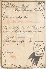
Document - Certificate, The Eltham Barrel Beer Drinking Contest: Awarded to Rex "Young Pommy" Whitworth, 19 July 1974
The Eltham Beer Barrel Drinking Contest This is to certify that Rex "Young Pommy" Whitworth Has successfully downed 10 Grogs, and is still standing to sign this certificate! Signed R. Whitworth Dated this eventful 19th day of July 1974 Manager (signature illegible) Rex, a carpenter, was registered to vote in 1963 and was recorded as living in Storey Avenue, Research. He was still living at the same address in 1980. Given Rex had to be at least 21 years of age in 1963 (to be eligible to vote), that would make him at least 32 in 1974.Rex "Young Pommy" Whitworth signature, date and signature of Managereltham barrel, rex whitworth, certificate, beer drinking contest, award -
 Kew Historical Society Inc
Photograph - 'Fernhurst', 13 Fernhurst Grove, 1978
George Wharton arrived in Melbourne in 1844. An architect and surveyor, he was appointed to lay out the 'Village of Kew' by N.A. Fenwick following the land sales of 1851. A protagonist for Kew's separation from the Boroondara District Road Board, he was elected chairman when Kew achieved municipal status in December 1860. His home, 'Fernhurst', was built in 1866 on eight acres in Studley Park, with a four-storey tower and pyramidal roof. The Italianate home was a prominent Kew landmark. It was demolished in 1979 and replaced by St Paul's College in 1980.Rare colour photograph of what was once a significant mansion in Kew.Original colour positive photograph (Kodak print) of 'Fernhurst' in 1978. Photographed by Stewart West in May 1978, one year before it was demolished, the photograph gives little idea of the large landholding once surrounding the house. Originally accessed from near the corner of Princess Street and Studley Park Road, its gardens had been subdivided in the 1900s and its footprint restricted to 13 Fernhurst Grove. Like many other grand houses, by the 1970s it had been converted into apartments. From the photograph, one can see that the house had retained many of its original features such as the distinctive tower and the wide bow-fronted verandah. The slates on the roof (apart from those on the tower) had been replaced by tiles and the cement render of the exterior painted white. Annotated reverse: "View of Fernhurst Home Taken from Street / 10"fernhurst, 13 fernhurst grove -- kew (vic.), george wharton, italianate architecture, vila maria society, st paul's school for the blind -
 Kew Historical Society Inc
Photograph - 'Fernhurst', 13 Fernhurst Grove, 1978
George Wharton arrived in Melbourne in 1844. An architect and surveyor, he was appointed to lay out the 'Village of Kew' by N.A. Fenwick following the land sales of 1851. A protagonist for Kew's separation from the Boroondara District Road Board, he was elected chairman when Kew achieved municipal status in December 1860. His home, 'Fernhurst', was built in 1866 on eight acres in Studley Park, with a four-storey tower and pyramidal roof. The Italianate home was a prominent Kew landmark. It was demolished in 1979 and replaced by St Paul's College in 1980.Rare colour photograph of what was once a significant mansion in Kew.Original colour positive photograph (Kodak print) of 'Fernhurst' in 1978. Photographed by Stewart West in May 1978, one year before it was demolished, the photograph gives little idea of the large landholding once surrounding the house. Originally accessed from near the corner of Princess Street and Studley Park Road, its gardens had been subdivided in the 1900s and its footprint restricted to 13 Fernhurst Grove. Like many other grand houses, by the 1970s it had been converted into apartments. From the photograph, one can see that the house had retained many of its original features such as the distinctive tower and the wide bow-fronted verandah. The slates on the roof (apart from those on the tower) had been replaced by tiles and the cement render of the exterior painted white. Annotated reverse: "Fernhurst from higher ground level side shot / 7"fernhurst, 13 fernhurst grove -- kew (vic.), george wharton, italianate architecture, vila maria society, st paul's school for the blind