Showing 27608 items
matching yarra-river
-
 Greensborough Historical Society
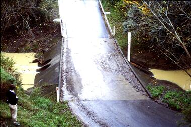
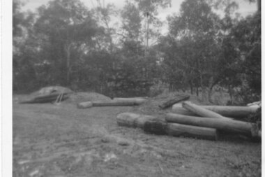
Slide - Photograph, John Ramsdale, Ford over Plenty River to Partington's Flat: Slide 72, 1990s
Photograph shows road or path over culvert. This is the ford over Plenty River to Partington's FlatPart of the John Ramsdale collection of slides and audio visual material.Colour photograph scanned from slide.No caption. Printed maker's mark on slide "Kodak Kodachrome Slide"ford over plenty river, plenty river, partington's flat -
 Greensborough Historical Society
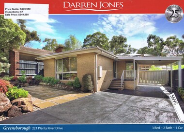
Advertising Leaflet, Darren Jones, 221 Plenty River Drive Greensborough, 13/05/2017
221 Plenty River Drive Greensborough. Three bedroom house, sold for $649,950 in July 2017. Real estate advertising leaflet, 1 sheet, printed in colour both sides. plenty river drive greensborough -
 Greensborough Historical Society
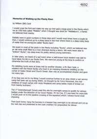
Document, Bill Cecil, Memories of walking up the Plenty River, by William (Bill) Cecil, 1950o
Bill Cecil remembers activities from his youth including rabbit hunting on the Plenty River1 page, typescriptplenty river, bill cecil -
 Greensborough Historical Society
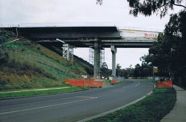
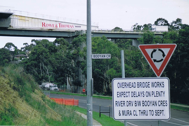
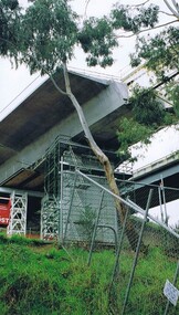
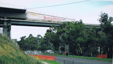
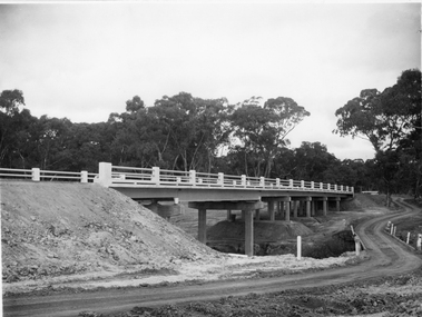
Photograph - Digital image, Frank Solomon, Plenty River Drive Bridge Roadworks 1, 1995c
These photos show the duplication of the bridge over Plenty River Drive on the Greensborough Bypass, circa 1995.Digital copy of colour photographplenty river drive, greensborough bypass -
 Greensborough Historical Society
Photograph - Digital image, Frank Solomon, Plenty River Drive roadworks 2, 2005c
These photos show the duplication of the bridge over Plenty River Drive on the Greensborough Bypass, circa 2005.Digital copy of colour photographplenty river drive, greensborough bypass -
 Greensborough Historical Society
Photograph - Digital image, Frank Solomon, Plenty River Drive Bridge Roadworks 3, 2005c
These photos show the duplication of the bridge over Plenty River Drive on the Greensborough Bypass, circa 2005.Digital copy of colour photographplenty river drive, greensborough bypass -
 Greensborough Historical Society
Photograph - Digital image, Frank Solomon, Plenty River Drive Bridge Roadworks 4, 2005c
These photos show the duplication of the bridge over Plenty River Drive on the Greensborough Bypass, circa 2005.Digital copy of colour photographplenty river drive, greensborough bypass -
 Greensborough Historical Society
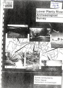
Report, Lower Plenty River Archaeological Survey; Fiona Weaver, 1989_
Archaeological survey of the Lower Plenty River undertaken in 1989-1990 by Fiona Weaver for the Board of Works. Indigenous heritage sites along the Plenty River are examined and recommendations made for the preservation and to lessen the impact of development on these sites.Printed on white A4 paper. Approx 92 pages (not numbered). Illus., maps. 2 copies.plenty river, board of works, aboriginal heritage sites -
 Stawell Historical Society Inc
Photograph, Campbell’s Bridge over the Wimmera River 1961
Newly built Campbell’s Bridge over the Wimmera River. Built by Redman Bros. Opened in 1961.stawell shire -
 Kew Historical Society Inc
Photograph - Flooding of the Yarra Valley at Kew East, 1974
Flooding of the Yarra Valley, including that section of the Yarra bordering Kew and Kew East in the north and west of the municipality, was a regular occurrence. Extreme flood events of the Yarra River are recorded to have occurred in 1891, 1901, 1916, 1923 and 1934. The Municipality of Kew's response to these floods was to enact planning decisions restricting residential development in flood prone areas following the floods of 1916, 1921 and 1934. While floods continued after the development of the Upper Yarra Reservoir (construction 1948-57), the regularity and extent of these inundations diminished. During the nineteenth century, the land abutting the south side of the Yarra in Kew was devoted to dairy farming. In the twentieth century, before and after the construction of the Eastern Freeway, much of this low-lying area was used as golf courses and public parks.Late example of the capacity of the Yarra Valley at Kew to flood, even though drainage works and the Upper Yarra Reservoir had reduced their regularity.Original black and white print photograph of the low-lying land at East Kew under floodwater on 16 May 1974. The vantage point of the photographer is Lister Street. In the photo, the fences of the Kilby Farm can be seen. Flooding was caused by overflowing water in Glass' Creek and the River Yarra. Annotation verso: "Hay's Paddock op No.30 Lister Street / 16 May 1974 11.50am / R.L. 46.04"hays paddock, floods, yarra river, glass' creek, lister street -
 Orbost & District Historical Society
black and white photographs, Snowy River Mail, 1960s
These photographs were taken at the annual Orbost Agricultural Show at the Newmerella Showground. They were probably published in the Snowy River Mail newspaper. Some of the Orbost identities pictured include : Russell Crofts, Kevin McDonald, Brian McDonald, Gail & Lee Winchester, Julie & Lisa Drummond, Marion Russell, Sylvia MurrayRod Kleinitz, Rober Morgan, Trevor Perry, Brian Woodlands, anna light, Louella Brunt, Colin Weir, Wendy Pinnock, Raeleen Reed, Margaret Joiner and Jo-anne Mundy. The first meeting to form an Agricultural society in Orbost was convened by the then Orbost Progress Association and held in the Mechanics Hall on Saturday, 10th October 1891. Its first show was held on 3rd March 1904...on a site alongside the Bonang Road where the present Golf Club stands. It is currently held at the Recreation Reserve at Newmerella. (Ref: In Times Gone By-Deborah Hall)These photographs are associated with the Orbost Agricultural Society 's Annual Show which has been a major event in Orbost for over a century. Agricultural shows are an important part of cultural life in small country towns and the Orbost Show is an integral part of Orbost 's agricultural history. Seventeen black / white phootgraphs which were taken at the Orbost Agricultural Show.orbost-agricultural-show -
 Lakes Entrance Regional Historical Society (operating as Lakes Entrance History Centre & Museum)
Postcard, Bulmer H D, 1920 c
Postcard lightly tinted of Mitchell River depicting the river at Eagle Point bluff with two men seated on bank, farm house in background Eagle Point VictoriaEagle Point, Mitchell Riverbridges, waterways -
 Greensborough Historical Society
Photograph - Digital image, Marilyn Smith et al, Janefield Precinct: View of river bend, 27/11/2014
Janefield Precinct: View of river bend. The remains of this site are between Greensborough and Janefield. A RAAF Hygiene Training Camp was located on the Plenty River, just south of the Janefield community. It was in use from 1944 to 1946. The Camp was constructed from salvaged materials. Instruction included building and maintenance of grease traps, latrines, elementary plumbing and carpentry.Early remains of a WW2 training camp Digital colour photograph.janefield -
 Robin Boyd Foundation
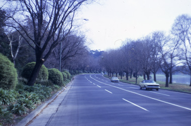
Slide, Robin Boyd, 1967
Colour slide in a mount. Alexandra Parade, by the Yarra River, South Yarra, Victoria, AustraliaMade in Australia / 28 / JUN 67M6 / Encircled 34 (Handwritten)slide, robin boyd -
 Greensborough Historical Society
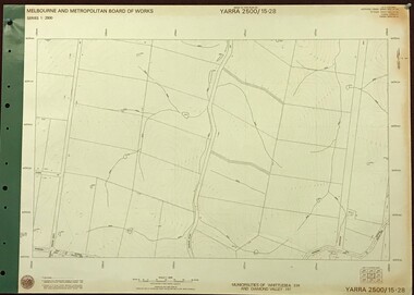
Map, Melbourne and Metropolitan Board of Works. Survey Division, MMBW, Yarra 2500 / 15.28. Yarrambat, 1977_10
Melbourne and Metropolitan Board of Works. Yarra 2500 [base map] 15-28. Yarrambat. Municipalities of Diamond Valley 257 and Whittlesea 239. Prominent streets include: Edward Henty Avenue, Charles Sturt Drive and Creighton Way. MMBW Map in 1:2500 [scale] series. Cream parchment with green tape reinforcing on edges and punched holes on left edge.mmbw, melbourne and metropolitan board of works, shire of diamond valley, yarrambat - maps -
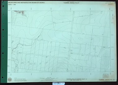 Greensborough Historical Society
Map, Melbourne and Metropolitan Board of Works. Survey Division, MMBW, Yarra 2500 / 14.27. Yarrambat, Youngs Road, 1977_09
Melbourne and Metropolitan Board of Works. Yarra 2500 [base map] 14.27. Yarrambat, Youngs Road. Municipalities of Diamond Valley 257 and Whittlesea 239. Prominent streets include: Youngs Road, Ashley Road and Yan Yean Road. MMBW Map in 1:2500 [scale] series. Cream parchment with green tape reinforcing on edges and punched holes on left edge.mmbw, melbourne and metropolitan board of works, shire of diamond valley, whttlesea, yarrambat - maps -
Kew Historical Society Inc
Collection, Floods in North Kew (Series), 1929–1934
Flooding of the Yarra Valley, including that section of the Yarra bordering Kew and Kew East in the north and west of the municipality, was a regular occurrence. Extreme flood events of the Yarra River are recorded to have occurred in 1891, 1901, 1916, 1923 and 1934. The Municipality of Kew's response to these floods was to enact planning decisions restricting residential development in flood prone areas following the floods of 1916, 1921 and 1934. While floods continued after the development of the Upper Yarra Reservoir (construction 1948-57), the regularity and extent of these inundations diminished. Natural disasters had an impact on the development and settlement of Melbourne and its suburbs. Flooding in the Melbourne region was a regular event in the nineteenth and for most of the twentieth centuries. Changes in the impact of natural disasters could occur due to a number of factors. This collection of small snapshots, mostly taken from Kellett Grove in North Kew, provide provenanced evidence of flooding in the area before the development of the unnatural flood barrier that is the Eastern Freeway.Collection of 16 monochrome photographs, annotated on verso by different hands, of the flooding of the River Yarra in North Kew in the third and fourth decades of the twentieth century [1920s & 1930s]. Individual photos include the dates of different floods. Many of the photos were taken from the rear of 8 Kellett Grove; a house still extant in 2023yarra river -- north kew, floods -- yarra valley, floods -- north kew, floods -- 1929, floods -- 1934, natural disasters -- kew -
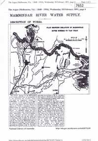 Greensborough Historical Society
Article - Newspaper Clipping (copy), The Argus, Maroondah River water supply 1891, 18/02/1891
An historical account of the development of Melbourne's Maroondah River water supply, including a description of works undertaken in the 1890s.3 p., photocopy of article, downloaded from Trove. Includes transcript in Word document.melbourne water, mmbw, maroondah aqueduct, yan yean reservoir, greensborough, plenty river -
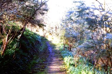 Greensborough Historical Society
Slide - Photograph, John Ramsdale, Along Plenty River near Para Road: Slide 86, 1990s
Photograph shows a track through bushland, along the Plenty River near Para Road, possibly Montmorency.Part of the John Ramsdale collection of slides and audio visual material.Colour photograph scanned from slide.No maker's marks. No caption on slide.plenty river, para road montmorency, bushland -
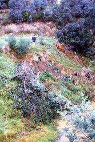 Greensborough Historical Society
Slide - Photograph, John Ramsdale, Slumping erosion along the Plenty River: Slide 110, 1990s
Photograph shows a man standing on an embankment which is being eroded. This is slumping erosion along the Plenty River.Part of the John Ramsdale collection of slides and audio visual material.Colour photograph scanned from slide.No maker's marks. Caption on slide "Plenty"plenty river, erosion -
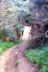 Greensborough Historical Society
Slide - Photograph, John Ramsdale, Crossing Plenty River: Slide 12, 1990s
Photograph shows erosion on a path to a footbridge over the Plenty River down from George Court Montmorency.Part of the John Ramsdale collection of slides and audio visual material.Colour photograph scanned from slide.No maker's marks. No caption on slide.plenty river, erosion, montmorency -
 Greensborough Historical Society
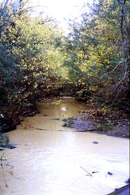
Slide - Photograph, John Ramsdale, Plenty River with European trees: Slide 24, 1990s
Photograph shows a section of the Plenty River with European trees and clay run-off from building nearby.Part of the John Ramsdale collection of slides and audio visual material.Colour photograph scanned from slide.No maker's marks. No caption on slide.plenty river, vegetation -
 Greensborough Historical Society
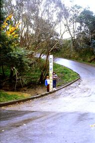
Slide - Photograph, John Ramsdale, Ford over Plenty River at Partington's Flat: Slide 52, 1990s
Photograph shows 2 children with flood height marker at the ford over Plenty River at Partington's FlatPart of the John Ramsdale collection of slides and audio visual material.Colour photograph scanned from slide.No maker's marks. No caption on slide.partingtons flat, ford over plenty river, plenty river -
 Greensborough Historical Society
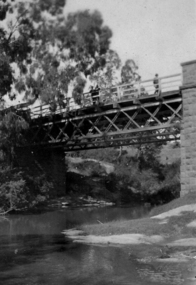
Photograph - Digital image, Bridge over Plenty River, 1930-1940
Photograph of old bluestone bridge over the Plenty River in Greensborough. This photo is from the Lorraine Coates Collection.Digital copy of black and white photograph.plenty river greensborough, bluestone bridge greensborough -
 Greensborough Historical Society
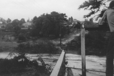
Photograph - Digital Image, Plenty River in flood 1972 (1), 1972_
Plenty River in flood near Greensborough. There were two major floods in Greensborough at the time, 1972 and 1974.Digital copy of black and white photograph.plenty river, floods -
 Greensborough Historical Society
Photograph - Digital Image, Plenty River in flood 1972 Flintoff Street Crossing (2), 1972_
Plenty River in flood, circa 1972. There were two major floods in Greensborough at the time, 1972 and 1974.Digital copy of black and white photograph.plenty river, floods -
 Stawell Historical Society Inc
Photograph, "Woodlands" Homestead near Crowlands on Wimmera River by Johann von Guerard 1869 -- Photo of an Oil Painting
Photograph of Oil on Canvass of Woodlands Homestead near Crowlands on Wimmera River 1869 by Johann von Guerardstawell -
 Stawell Historical Society Inc
Photograph, Bridge over Wimmera River at Glenorchy
Bridge over Wimmera River at Glenorchy. Church in background on right is the former Presbyterian now united church.water -
 Eltham District Historical Society Inc
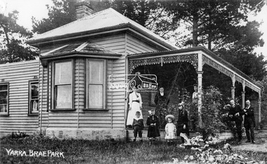
Negative - Photograph, Yarra Brae Park, c.1900
Weatherboard house with cast ironwork decoration on the verandah. Three women, two men and four children with rocking horse stand for a photograph. Family unknown. Yarra Brae Park was situated on Yarra Brae Road, off Sweeneys Lane, Eltham. Research in historical newspapers reveals that the Hautrive family lived there 1904-1906, followed by the Bindoon family in 1907. In the 1930s it was occupied by Hubert Rutter, his wife Beulah and four children. Hubert was an Eltham Shire Councillor. On 13 January 1939, the house burned down in the Black Friday bushfires. After the fire, the family relocated to Toorak. Reproduced on p91 of 'Pioneers & Painters'This photo forms part of a collection of photographs gathered by the Shire of Eltham for their centenary project book,"Pioneers and Painters: 100 years of the Shire of Eltham" by Alan Marshall (1971). The collection of over 500 images is held in partnership between Eltham District Historical Society and Yarra Plenty Regional Library (Eltham Library) and is now formally known as 'The Shire of Eltham Pioneers Photograph Collection.' It is significant in being the first community sourced collection representing the places and people of the Shire's first one hundred years.Digital image 4 x 5 inch B&W Neg Sepia postcard and B&W printsepp, shire of eltham pioneers photograph collection, eltham, yarra brae park, verandah, cast iron work, hautrive family, bindoon family, rutter family, pioneers and painters, houses, groups -
 Eltham District Historical Society Inc
Document - Survey Plan, Country Roads Board, SP 6801, Eltham-Yarra Glen Road; Brougham St to Bridge St, 1958
1958 C.R.B. Plan of Survey of Part of Crown Portion 12 Section 4 Parish of Nillumbik, County of Evelyn Eltham-Yarra Glen Road, Shire of Eltham Shows Surveyor field notes, property ownership and building type and construction.a.j. collis, a.s. & c.g.h. fitzpatrick, board of land & works, bridge street, brougham steet, commonwealth bank of australia, country roads board, eltham, eltham rsl sub-branch, f.h. collis, f.m. smith, f.n. & e.j. burgoyne, franklin street, h.c. & r.e. burgoyne, j. jorgenson, j.f. & j.e. morris, j.n. & h.c. burgoyne, j.s. blow, john street, main road, p.e. smith, pitt street, r.j. dripps, s.j. taylor, survey plan, trustees of the eltham methodist church, 1958, eltham-yarra glen road, neil webster collection