Showing 17972 items matching "shows"
-
 Ballarat Tramway Museum
Photograph - Black & White Photograph/s, Peter Bruce, c1970
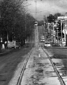
Black and white photograph of Barkly St. Mt Pleasant taken with a long telephoto lens. Single truck Tram on the top of a hill at terminus, with the photographer on or near the top of the`next hill in centre of track. Four cars travelling towards photographer. Sign of Caltex Service station on right side of photograph. with trees on left. Shows nature of street construction - deep gutters with "bridge" crossings. See also item No. 559, possibly tram No. 31. Would appear to be taken at about the same time, not parked Holden station wagon on left hand side of photo.trams, tramways, ballarat, barkly st, mt pleasant -
 Ballarat Tramway Museum
Photograph - Black & White Photograph/s, Ian Barkla, c1960
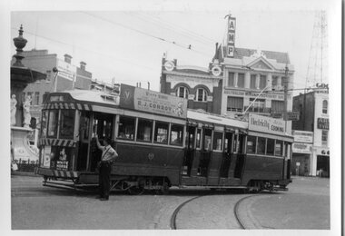
Black and white photograph of Bendigo 3 at Charing Cross, with the Fountain in left hand edge of photograph. Photo shows the curve from View St. into Pall Mall. Tram has "White Horse" whiskey ad and another ad on the drivers dash panel, an SEC roof ad on the rear of the tram and R.J.Conroy's Victa Mowers roof ad on the front of the tram. Conductor in a short sleeved shirt, is standing at front of tram talking to the driver. AMP and CML buildings in background. Tram has been fitted with dash canopy lighting, but not the enlarged white strip. Not dated.On rear in black biro "Bendigo No. 3 at the Fountain ' Ex Geelong 32, Ex 122 MMTB".trams, tramways, bendigo, charing cross , tram 3 -
 Ballarat Tramway Museum
Slide - 35mm slide/s, late 1960's
Agfa plastic mount (blue base, white cover) of a photograph of No. 37, Albert St. inbound, side on and an elevated view looking at tram – note section switch on powerline. Could be on a Special tour, given the passenger loading on the tram. Photo taken late 1960's. The slide appears to be a copy slide, given the nature of the colour and the additional number WP417. Photographer could be Bill Pearce (WP). Slide rescanned at 3200 dpi 25-10-2020, jpg replaced, tiff file retained. This file was scanned in 2003 and may show colour changes."BAS 56 in penciltramways, trams, albert st, sebastopol, tram 37 -
 Ballarat Tramway Museum
Slide - 35mm slide/s, Harry Jackson, Sep. 1971
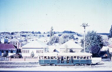
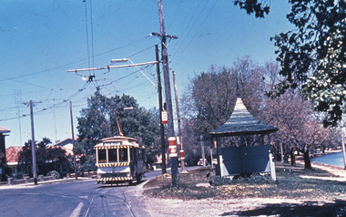
Agfa plastic mount (blue base, white cover) of a photograph of No. 17 entering Gardens loop, with the Destination of Mt Pleasant. Has the Gardens Kiosk, Lake Lodge in the background. Photo taken 9/1971. One of a set of 20 slides made by the Association of Railway Enthusiast Provincial Tramways film strip. Reference Item 2560 details the ARE Film Strip and provide references to other slides. Slide rescanned at 3200 dpi 25-10-2020, jpg replaced, tiff file retained. This file was scanned in 2003 and may show colour changes. "BAS 63" in pencil.tramways, trams, wendouree parade, gardens loop, tram 17 -
 Ballarat Tramway Museum
Slide - 35mm slide/s, Nov. 1970
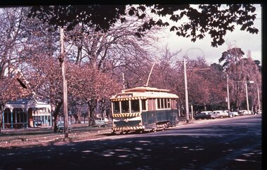
Agfa plastic mount (blue base, white cover) of a photograph of No. 21 at View point terminus. Note tram stop arrangements, shelter and the Lake in the Background. Photo taken 11/1970. One of a set of 20 slides made by the Association of Railway Enthusiast Provincial Tramways film strip. Reference Item 2560 details the ARE Film Strip and provide references to other slides. Slide rescanned at 3200 dpi 25-10-2020, jpg replaced, tiff file retained. This file was scanned in 2003 and may show colour changes."BAS 64" in pencil.tramways, trams, wendouree parade, view point, tram 21 -
 Ballarat Tramway Museum
Ephemera - Ticket/s, J.J. Miller, ESCo 3d, early to mid 1920's to 1930's
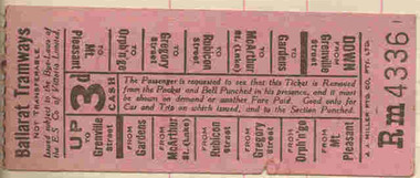
Ticket contained within Reg. Item 2488, page 31, 3d ticket on a pink colour, light weight card stock used by ESCo c1930's, Numbered Rm 4336, has various destinations for nipping on sides for both directions of travel. Printed by J.J. Miller Melb. Printing in black ink. Ticket has been nipped or cancelled. The ticket conditions note that the ticket must be "Bell Punched" when issued by the conductor. Note Item Not formally Numbered. Image btm2494i2 shows position on page relative to items 2494 to 2504.Some inscriptions about the ticket in pencil.trams, tramways, tickets, bell punch, esco -
 Ballarat Tramway Museum
Photograph - Black & White Photograph/s, late 1920's
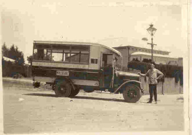
Yields information about a vehicle the Electric Supply Co of Victoria used to provide additional services in Ballarat in the face of bus competition. See page 59 of Golden City and its Tramways for further information.Black and white photograph contained within Reg. Item 2488, page 55, of ESCo or Ballarat Tramways motor bus, with the destination of Mt. Pleasant on the side. Driver W. Irwin? Handwritten caption by H.P. James. Note Item Not formally Numbered. Image btm2507i2 shows position on page relative to items 2507 to 2512. For a copy photograph of this image, see Reg Item 3813. High Res Images added 15/3/2011. Digital scan of a negative in the Wal Jack Collection added 21/4/2019 as image btm2510i4Handwritten in Pencil under the photograph is "Here is an interesting picture. Note the driver he is W. Irwin who gave me these pictures for which I am very grateful. The bus petrol engine International type was formerly in the possession of, one, Cruickshanks, an independent driver with a permit from the council to run between The Point of Pictures?, Ness St, Mt Pleasant via Bond St, Peel St. to City but the Electric Supply Coy purchased the vehicle and ran it from 1927 to 1929 (unpayable). The most use it was put to was on Mt Pleasant, but it ran also to High School as replacement for trams on Sebas if an electric tram was derailed. Perhaps the most unique trips it ever made was between Forest St. Wendouree to the Aerodrome, 1929, on the occasions of any ?? flight. Again Mr Irwin was the driver (& made two trips)"tramways, trams, esco, motor buses, mt pleasant, cruickshanks -
 Ballarat Tramway Museum
Photograph - Black & White Photograph/s, The Courier Ballarat, 25/05/1970 12:00:00 AM
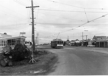
Yields information about Ballarat's tramway system Sebastopol route, where the tram crossed to the side of the road and the streetscape at that point.Black and White copy photograph taken by The Courier, published 25/5/1970 of No. 18, Albert St & Rubicon St corner, showing remains of tree that had previously impeded motorists' view of trams. Shows the Ford dealership on the left hand side, along with the remains of the tree, and shops on the west side, including Dickins Food Stores, a newsagent and a chemist. Collected by Alan Bradley from the Ballarat Courier early 1980's. See Excel file "Record of Ballarat Courier Photos SEC era" (Archive Documents) for source of details.On rear stamped "Copyright, The Ballarat Courier Proprietary Limited."tramways, trams, albert st, sebastopol, tram 18 -
 Ballarat Tramway Museum
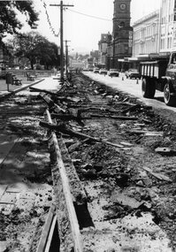
Photograph - Black & White Photograph/s, The Courier Ballarat, Jan. 1972
Yields information about the demolition or removal of the track along the Sturt St and how it was done.Black and White copy photograph of a newspaper photograph taken by The Courier - photo taken 25/1/1972, published 26/1/1972 of Rail being removed from Sturt St, near Town Hall. Shows rails, sleepers etc. Has Myer shop in the background. See Reg Item 2216 for the Newspaper cutting the photo used in. Collected by Alan Bradley from the Ballarat Courier early 1980's. See Excel file "Record of Ballarat Courier Photos SEC era" (Archive Documents) for source of details.On rear stamped "Copyright, The Ballarat Courier Proprietary Limited."tramways, trams, sturt st, track removal, closure, rails -
 Ballarat Tramway Museum
Photograph - Black & White Photograph/s, 1905
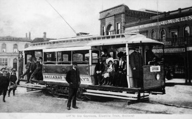
Yields information about the opening configuration and early passengers of the tramways in Ballarat, with the Sturt and St Grenville St buildings behind. Shows uniforms and clothing styles.Black and White copy photograph of a Ballarat Municipal library (No. 911) postcard at the time of the opening of the Electric tramway in Ballarat. Tram has destination of Gardens, with four crew/inspector in uniforms, a number of well dressed passengers including ladies and children and some boys at the rear. Shows arrangements of steps lining etc. In the background is the Bucks Head Hotel, a Confectioner (J.M. Kiln?) and other buildings. Photo taken in 1905. Collected by Alan Bradley from the Ballarat Municipal library early 1980's. Used in The Golden City and its Tramways - front covertramways, trams, sturt st, electrification, grenville st, opening -
 Ballarat Tramway Museum
Photograph - Black & White Photograph/s, State Electricity Commission of Victoria (SECV), 1935
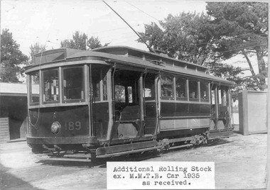
Yields information about the rehabilitation of the Ballarat tram fleet and the condition and appearance of the trams that were received from Melbourne to enable this.Black and White photograph contained within Reg. Item 3000 - Photo Album produced by the SEC in 1935 titled "Photographs of Ballarat Tramways Rolling Stock & Track Reconditioning Works". Black and white photograph, of ex Melbourne and Metropolitan Tramways Board No. 189, later to become SEC No. 33, in the Ballarat depot yard in 1935. Has caption on photograph of "Additional Rollingstock ex M.M.T.B. Car 1935 as received." Shows arrangement prior to any conversion work. "The caption has been adhered to the photograph. See also Reg. Item 1356 for copy prints. tramways, trams, mmtb, secv, tramcars, ballarat, rehabilitation, conversion, tram 189, tram 33 -
 Ballarat Tramway Museum
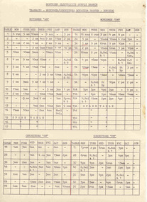
Document - Roster, State Electricity Commission of Victoria (SECV), "Tramways - Motormen/Conductors Rotation Roster - Bendigo", 1970
Significant in being a roster rotation sheet for Bendigo that used a different method of advising crews of the system of tables and weeks. Shows how the system was used. Given date, may have been the last one issued.Printed form titled "Tramways - Motormen/Conductors Rotation Roster - Bendigo" for Bendigo Tramways. Duplicated foolscap size paper, giving roster for motormen and conductors AM and PM rosters. Duplicated form in black ink with a red line drawing to split the AM and PM rosters and two tables on Monday underline. Gives details of the run, tables for each day of the week and shows Spare Tables. Headed "Northern Electricity Supply Branch" Five copies held. Copy 1 has pencil date "29 June 1970" in top right hand corner. trams, tramways, tram crews, shifts, rosters -
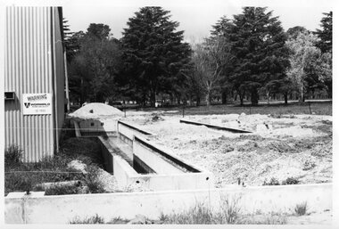 Ballarat Tramway Museum
Photograph - Black & White Photograph/s - set of 2, 1978
Yields information about the construction of the BTPS Depot in the Gardens.Black and white photograph of the two stages of the extension of the BTPS depot in 1978/1979. The first photograph shows the depot pits constructed and the building foundations in position. The second photograph of the first stage of the steel erection. Reference Annual reports - 1977 - 1978 - concrete finished except for backfiring. 1978 - 1979 - steel partially up - Christmas 1978, started November 1978. Photographer of item 2 (and may be other photos ex the album) was Graham Jordan - see history of the object. See BTPS Annual Reports, 1977-78 and 1978 - 1979.tramways, trams, btps, depot extensions, depot -
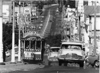 Ballarat Tramway Museum
Photograph - Black & White Photograph/s, Herald Sun, 16/04/1972 12:00:00 AM
Yields information the operation of Bendigo trams in View St Bendigo, on the Eaglehawk route, and the delivery of the tram to Eaglehawk following closure.Black and White photograph of Bendigo No. 26 climbing View St, Bendigo with the destination of Eaglehawk and a "Borough of Eaglehawk sign" on the front dash panel. Photo taken with a large telephoto lens to show up the hill. Has Mitchell St in the background and a number of cars in the foreground. Photo taken on the last day of operation - used in Keith Dunstan's "A Place in the Sun" 17/4/1972. Herald Sun newspaper photograph. Printed on Agfa paper. For a copy of the newspaper article see Reg. Item 2229. See A Place in the Sun 17/4/1972.On rear in ink "ED15/215" and "17/4/72" in ink and a "Herald Sun Newspaper copyright" stamp - very faint green ink.tramways, trams, bendigo, eaglehawk, closure, view st, tram 26 -
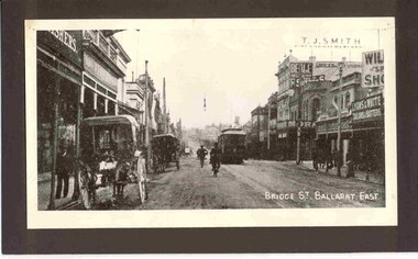 Ballarat Tramway Museum
Photograph - Black and White photograph/s - mounted, 1906
Black and white photograph mounted onto black cardboard backing (blue back cardboard) of an ESCo tram in Bridge St Ballarat, looking east. Photograph of a postcard, has title "Bridge St. Ballarat East" in the bottom right hand corner. Original photograph taken soon after opening of the tramway in Bridge St., no windows and no destination box on the roof of the tram. Shows two horse drawn wagons on the left hand side of the photograph. Has shops or advertising signs of Lyons & White Tailors and Hatters, T. J. Smith, Suttons and Beale Australian ?.trams, tramways, bridge st, esco, postcards -
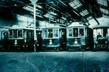 Ballarat Tramway Museum
Slide - 35mm slide/s, prior 1924
Agfachrome Professional plastic mount (blue base, white cover) reproduction slide of a black and white photograph of Geelong Nos 8, 4, 1 and another 4 wheel tramcar and a open cab motor bus photographed within the interior of Geelong depot, prior to 1924. From notes provided by David O'Neil, 12/2003, advises that bus driver is either Bill Hamaling or Charles Stafford. Gentlemen next to No. 8 could be Vic Phipps. Hawthorn Tram Museum Reg Item 3558 shows the tram on the left hand side - Geelong 2."G 1" and "1 -1" in pencil.tramways, trams, geelong, depot, motor buses, tram 8, tram 4, tram 1 -
 Ballarat Tramway Museum
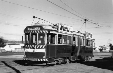
Photograph - Black & White Photograph/s, Doug Colquhoun, Ballarat 40 at the Sebastopol terminus, 15/05/1971 12:00:00 AM
Yields information about Ballarat tram 40 and the Sebastopol terminus.Black and white print of Ballarat 40 at the Sebastopol terminus. Two copies. Photo by Doug Colquhoun, 17/5/1971. Trams has the destination of Lydiard St Nth and roof advertisements for Eureka Tiles and Bliss Bombs (To read pack: Tilt Tram"). Also has the houses in the background and shows the overhead arrangements. Photo print courtesy of Port Dock Railway Museum, now the National Railway Museum. See worksheet 4311 for letter and details of prints sent to Bill Scott, 19/10/2001. Any photo credit to mention NRM Collection.On rear of copy 1 "SEC Ballarat / 40 / Sebastopol terminus / 17/5/71 4179 / D.A. Colquhoun" . Copy 2 "Douglas Colquhoun / 5.1971 National Rly Museum" in ink, bottom right hand corner and in the top left hand corner in ink "Car 40 SEC Tramways Ballarat Vic 3350"trams, tramways, sebastopol, tram 37 -
 Ballarat Tramway Museum
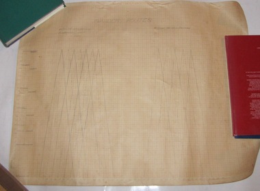
Document - Roster, Electric Supply Co. of Vic (ESCo), "Gardens Routes", 1910's?
Yields information about the planning options that were used for formulate garden routes timetables at various service levels.Single rolled graph sheet which has two sets of runs drawn on it, showing the Gardens via Convent and Ripon St routes from Grenville showing how the tram service would operate and where the trams crossed each other. One graph set shows a 6 car, 7.5 min service and the other a four 10 minute service. Gives the miles and minutes. Would have been used to prepare rosters and timetables. Possible 1910's given Reg Item 4738, which can in the same set of donations. trams, tramways, ballarat, rosters, shifts, timetables -
 Ballarat Tramway Museum
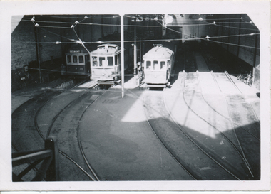
Photograph - Black & White Photograph/s, Wal Jack, 24/06/1949 12:00:00 AM
Black and White print contained within the Wal Jack Bendigo and Geelong Album, see Reg Item 5003 for more details. Photo of Geelong Nos 36, 3 and 31 at the depot building entrance, or inside depot, 24-6-1949. Photo by Wal Jack from the Roster Room landing. Shows the depot track arrangements. See Also Reg item 5891 for a ground level photograph. i1 - scan of print in the album i2 - rear of image i3 - scan of negative at 3200dpi added 18/6/2020. On rear in ink SEC Geelong / Nos. 36, 3, 31 inside depot from Roster Room landing / 24-6-1949". Has the Wal Jack copyright stamp in the top right hand corner with the number T296 written in.trams, tramways, geelong, depot, tram 36, tram 3, tram 31 -
 Bendigo Historical Society Inc.
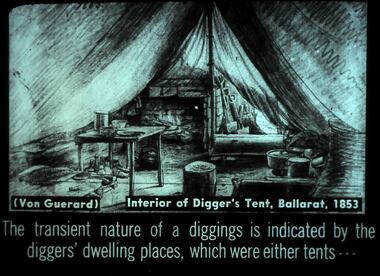
Slide - DIGGERS & MINING. DIGGERS AND MINERS, c1853
Diggers & Mining. Diggers and miners. (Von Guerard) Interior of a digger's Tent, Ballarat, 1853. The transient nature of a diggings is indicated by the digger's dwelling places, which were either tents - - - Slide shows that only the bare necessities were found in a miner's tent. You would find a table, a stump for a stool, makeshift bed, cooking posts and kettle, under the table you can see a pair of boots and some items that may be ingredients for cooking. On the wall hang some shovels. Markings: 34 994:LIF I. Used as a teaching aid.hanimounteducation, tertiary, goldfields -
 Ballarat Tramway Museum
Sign, State Electricity Commission of Victoria (SECV), "CARS TAKE FOLLOWING LINE"
Galvanised sheet steel with top & bottom holes(central) & side mounting brackets & rounded corners. Painted with black base and white letters and lines used to indicate which depot track(Line) trams were to be parked or stabled on when returning to the depot. Depot had four under cover tracks (1 to 4) and one outside track ("0") road. Lettered as shown on the sketch on the original worksheet. Reg. Item No. 1170.1? shows the object in a wooden frame mounted onto a pole opposite the depot, by depot junction point.trams, tramways, depot, secv, ballarat, tramcar operations, operations -
 Kew Historical Society Inc
Plan - Subdivision Plan, J R Mathers & McMillan, Normanby Estate, c.1913
The Kew Historical Society's map collection includes a substantial number of real estate subdivision plans, mainly of Kew but also of surrounding suburbs in Melbourne. Most of the subdivision plans date from the 1920s and 1930s when the districts old homes and local farmland were being split up to accommodate residential growth in the postwar period. These early plans were assembled by a local firm, Jas R Mather & McMillan, which had an office in Cotham Road. Many of the plans, and sometimes photos, were annotated by the agents.Subdivision plans are historically important documents used as evidence for the growth of suburbs in Australia. They frequently provide information about when the land was sold as well as evidence relating to surveyors and real estate and financial agents. The numerous subdivision plans in the Kew Historical Society's collection represent working documents, ranging from the initial sketches made in planning a subdivision to printed plans on which auctioneers or agents listed the prices for which individual lots were sold. In a number of cases, the reverse of a subdivision plan in the collection includes a photograph of a house that was also for sale by the agent. These photographs provide significant heritage information relating house design and decoration, fencing and household gardens.The photograph may also be aesthetically significant depending on the importance of the photographic atelier.The Normanby Estate, which was adjacent to Normanby Road, Kew East, included thirty-one lots for sale. Streets on the subdivision plan include Adeney Avenue, Park Hill Road, Normanby Road, Weir Street and Wharton Street. Cotham Road and its tramway are shown nearby. The plan is interesting as it shows Wharton Street, named after the architect and town planner George Wharton, who was the first chairman of the Municipality of Kew. The street was to later be renamed Cecil Street. Also shown are proposed ‘Municipal Gardens’ where Parkhill Drive is now located."D" in top left corner. Stamped auctioneers contact details: "Jas. R. Mathers & Son & McMillan / Auctioneer & Land Salesmen, / 271 Collins Street / Melbourne" and Jas. R. Mathers / Estate & Financial Agent / Cotham Road / Kew".weir street - kew, wharton street - kew, normanby road - kew, cotham road - kew, municipal gardens - kew, park hill parkhill road - kew, braemar - kew, subdivision plans - kew -
 Kew Historical Society Inc
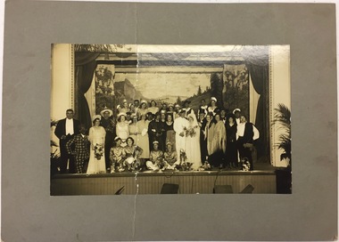
Photograph, Cast Members, Kew Presbyterian Church, 1925-1935
The Kew Presbyterian Church was located in Cotham Road, Kew on the corner of Highbury Grove. The Church Hall was located next door in Highbury Grove. On amalgamating with the Uniting Church the buildings became redundant and are now the Kew Chinese Baptist Church.Original photograph from the 1930s that records the kinds of social and spiritual actions of church goers in Kew.Members of the cast of a performance take a certain call at the end of a performance. The item was part of a group of photos relating to the Kew Presbyterian Church, so it may show a performance in which members of the church participated or led. The location of the performance is unclear; it might be at the Kew Recreation Centre or in the Kew Presbyterian Church Hall. Intriguingly, what look to be bunya bunya pines appear in the distance above the proscenium. The photograph was originally identified as possibly being the Kew Light Opera Company, however the photograph precedes its foundation. It is more likely to be a performance by a church group.cast photographs, theatre - melbourne -
 Kew Historical Society Inc
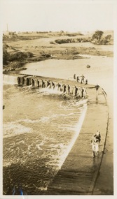
Photograph - Victorian Canoe Club, Dight's Falls, Studley Park, 1920-30
Canoeing on the River Yarra at Melbourne was an important and widespread recreational pursuit for Melbournians, especially in the first half of the twentieth century. The Victorian Canoe Club was formed in 1912 at a meeting in Melbourne and its first committee elected in the same year. Records indicate that the Club continued into at least the 1950s .The album has historic and social significance as a record of recreational activities (as well as canoe making) in the early years of the twentieth century. It has local significance as the site of the headquarters of the Club was in Studley Park. A number of photographs in the album provide vistas of Kew on the Yarra that are otherwise unavailable.One of 24 labelled photos in part album, originating from the Victorian Canoe Club, which had its headquarters in Studley Park, Kew. The album includes a photographic record of canoe construction and also locations in Studley Park and Kew where the canoes were used. The subject of this photograph is identified as 'Dight's Falls, Studley Park'.The view is from above and shows an early trestle bridge across the Falls on which people, possibly members of the Club, are walking or standing. The point of view would appear to be looking up river towards Fairfield."Dyghts Falls, Studley Park"victorian canoe club, river yarra, burke road -- kew (vic.), dight's falls -- fairfield (vic.), dight's falls -- kew (vic.), dight's falls -- yarra river -
 Kew Historical Society Inc
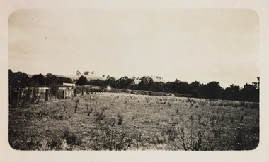
Photograph - Rural landscape and bridge, c.1926
Henry Beater Christian (1886-1962) , was a descendant of one of the earliest settler families in Kew. Employed at the Kew Asylum as a 'public servant', he was a skilled amateur photographer, photographing numerous scenes in Kew and on his travels around Victoria. The majority of his photographs date from 1916 to 1929. His finest photographs are housed in two photograph albums. Digital copy of a photograph from page 18 of the 47-page photograph album containing 261 gelatinous silver images, loaned by Diane Washfold with permission given to digitise and hold a copy in our collection. This photograph, dating from c.1926, forms part of a group of photos taken on a bushwalking trip to Marysville, Victoria. John Chapman has written in 'Bushwalking Clubs - A Brief History', about the establishment in Victoria of the first bushwalking club in 1888, and the popularisation of bushwalking during the interwar period. The photograph shows a post and rail wooden bridge in the distance."Spur" [illegible ink inscription]henry beater christian (1886-1962), landscape photography, kew (vic.) — yarra river, christian-washfold collection, photograph albums, bushwalking -- victoria, strickland spur -
 Kew Historical Society Inc
Plan - Subdivision Plan, Normanby Estate, East Kew, 1913
Pru Sanderson, in her groundbreaking ‘City of Kew Urban Conservation Study : Volume 2 - Development History’ (1988), summarised the periods of urban development and subdivisions of land in Kew. The periods that she identified included 1845-1880, 1880-1893, 1893-1921, 1921-1933, 1933-1943, and Post-War Development. These periods were selected as they represented periods of rapid growth or decline in urban development. An obvious starting point for Sanderson’s groupings involved population growth and the associated economic cycles. These cycles also highlighted urban expansion onto land that was predominantly rural, although in other cases it represented the decline and breakup of large estates. A number of the plans in the Kew Historical Society’s collection can also be found in other collections, such as those of the State Library of Victoria and the Boroondara Library Service. A number are however unique to the collection.The Kew Historical Society collection includes almost 100 subdivision plans pertaining to suburbs of the City of Melbourne. Most of these are of Kew, Kew East or Studley Park, although a smaller number are plans of Camberwell, Deepdene, Balwyn and Hawthorn. It is believed that the majority of the plans were gifted to the Society by persons connected with the real estate firm - J. R. Mathers and McMillan, 136 Cotham Road, Kew. The Plans in the collection are rarely in pristine form, being working plans on which the agent would write notes and record lots sold and the prices of these. The subdivision plans are historically significant examples of the growth of urban Melbourne from the beginning of the 20th Century up until the 1980s. A number of the plans are double-sided and often include a photograph on the reverse. The Normanby Estate, which was adjacent to Normanby Road, Kew East, included thirty-one lots for sale. Streets on the subdivision plan include Adeney Avenue, Park Hill Road, Normanby Road, Weir Street and Wharton Street. Cotham Road and its tramway are shown nearby. The plan is interesting as it shows Wharton Street, named after the architect and town planner George Wharton, who was the first chairman of the Municipality of Kew. The street was to later be renamed Cecil Street. Also shown are proposed ‘Municipal Gardens’ where Parkhill Drive is now located.subdivision plans - kew, normanby estate -
 Kew Historical Society Inc
Map, MMBW, MMBW Town of Kew, 1910-21
The Melbourne and Metropolitan Board of Works (MMBW) was established by an act of the Victorian Parliament in 1890 to prepare for and to implement a sewerage and water reticulation system across what was then inner Melbourne, its surrounding and middle distance suburbs, including Kew. The MMBW was disbanded in 1991.The map collection of the Kew Historical Society has at its core the historic maps assembled and originally stored in the City Engineer's Department of the City of Kew. These include maps in a number of scales. The vast majority of maps were produced by the MMBW in the first two decades of the twentieth century, and are solid working maps, backed by linen for durability. These maps are historically significant to Kew, the City of Boroondara and to the history of the development of state utilities in Victoria. A number of the Kew maps have additional details added by former municipal officers, including the levels reached by various floods. As these were working documents, information was added to them long after the period of their initial production and distribution.Early map of the Town of Kew, created after 1910, at a scale 440 ft to 1 inch. The 'assembled' map by the City of Kew Engineer's Department includes scaled down copies of The Melbourne and Metropolitan Board of Works maps, Nos. 39, 40, 64, 65, 66, 67, 68, and 117. The map covers the entirety of the Town of Kew, bordered on its north and west by the River Yarra, by Burke Road in the East and Barkers Road in the south. The map shows the extent of urban development by that time, prominent institutions and the outlines of built structures in the municipality. TOWN OF KEW / SCALE 400 FEET TO 1 INCHmelbourne & metropolitan board of works, mmbw maps, mmbw plans, town of kew, cartography -
 Kew Historical Society Inc
Map, MMBW, MMBW Plan No.40 Collingwood & Kew, 1900-1910
The Melbourne and Metropolitan Board of Works (MMBW) was established by an act of the Victorian Parliament in 1890 to prepare for and to implement a sewerage and water reticulation system across what was then inner Melbourne, its surrounding and middle distance suburbs, including Kew. The MMBW was disbanded in 1991.The map collection of the Kew Historical Society has at its core the historic maps assembled and originally stored in the City Engineer's Department of the City of Kew. These include maps in a number of scales. The vast majority of maps were produced by the MMBW in the first two decades of the twentieth century, and are solid working maps, backed by linen for durability. These maps are historically significant to Kew, the City of Boroondara and to the history of the development of state utilities in Victoria. A number of the Kew maps have additional details added by former municipal officers, including the levels reached by various floods. As these were working documents, information was added to them long after the period of their initial production and distribution.Early map of part of the Borough of Kew, created in the first decade of the twentieth century, at a scale 160 ft to 1 inch. The map covers what was then the south western section of Kew, bordered on its north by Studley Park Road, in the west by Walmer Street and the River Yarra, by High Street South and Princess Street in the East and Barkers Road in the south. The map shows the extent of urban development by that time, prominent institutions and the outlines of built structures in the municipality. Contour lines and historic flood levels were added in ink to the map at a later stage.MELBOURNE AND METROPOLITAN BOARD OF WORKS / PLAN NO. 40 / COLLINGWOOD & KEWmelbourne & metropolitan board of works, mmbw maps, mmbw plans, borough of kew, cartography -
 Mont De Lancey
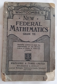
Book, Whitcombe' & Tombs Limited, Whitcombe's New Federal Mathemetics Grade VII, 1938
This is a New Federal Mathematics book for Grades VII students specially written to meet the requirements of the Revised Victorian Course of Study in Elementary Schools - it has charts, tables, symbols, diagrams, tests, explanations of processes and where possible the methods follow actual trade and business are taught practically. A special feature is the short methods and common sense approximations, including rough estimates. Sets of short problems are included.dark and light grey softcover book Whitcombe's New Federal Mathematics Grade VII with decorated scroll pattern at the top with information and publisher details written in black type on the front cover. Lance Sebire Wandin Yallock is handwritten in ink at the top. Within are diagrams, charts, tables, tests, exercises, rules, processes and explanations of procedures of mathematics. The methods follow actual trade and business where possible. Inside and outside the back cover are listed further Whitcombe's and Tomb publications. The book is quite damaged and shows it was well used. 128p.non-fictionThis is a New Federal Mathematics book for Grades VII students specially written to meet the requirements of the Revised Victorian Course of Study in Elementary Schools - it has charts, tables, symbols, diagrams, tests, explanations of processes and where possible the methods follow actual trade and business are taught practically. A special feature is the short methods and common sense approximations, including rough estimates. Sets of short problems are included.textbooks, handbooks, school, mathematics -
 Bacchus Marsh & District Historical Society
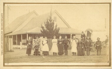
Photograph, Cheese Factory Waddell Street Bacchus Marsh 1883
The Cheese Factory in this image was opened around 1879 by Mr. G.G. Pearce. It was in Waddell Street. It was one of the first cheese factories in Victoria. It was later owned and operated by William Telford with the assistance of John Mahon. The factory was described in the Bacchus Marsh Express newspaper as an important business and service for the region. G.G. Pearce was reported to have spent a good deal of money in setting up the factory to ensure it was one which produced high quality cheese using modern methods of production. The factory was sold in 1889 to a Mr. H. W. King who was from Abbotsford in Melbourne. Unfortunately within a few days of Mr King buying the factory it was completely destroyed in a fire. All that was left were two large pine trees and two large underground concrete tanks.G.G. Pearce was described as a pioneer of cheese factories in Victoria. His first factory was just outside of Bacchus Marsh at Hopetoun. Around 1879 he moved into Bacchus Marsh and opened a new purpose built factory in Waddell Street. The Bacchus Marsh Express newspaper reported that no expense had been spared in constructing this factory. The factory was completely destroyed in a fire in 1889 which makes it fortunate that this image was captured of this early cheese factory in Victoria.Small sepia unframed photograph on card with gold border framing photograph. Housed in the album, 'Photographs of Bacchus Marsh and District in 1883 by Stevenson and McNicoll'. The image shows a group of men and women standing in a row in front of the Bacchus Marsh Cheese factory. One of the women is holding a small child. In front of another woman stands a young boy. Behind them is a covered wagon with a man seated upon it. Some of the men and women are wearing long aprons. In the background is the Cheese Factory. It is a large wooden structure with a high and steep pitched roof.On the front: Stevenson & McNicoll. Photo. 108 Elizabeth St. Melbourne. COPIES CAN BE OBTAINED AT ANY TIME. On the back: LIGHT & TRUTH inscribed on a banner surmounted by a representation of the rising sun. Copies of this Portrait can be had at any time by sending the Name and Post Office Money Order or Stamps for the amount of order to STEVENSON & McNICOLL LATE BENSON & STEVENSON, Photographers. 108 Elizabeth Street, MELBOURNE stevenson and mcnicoll 1883 photographs of bacchus marsh and district, cheese factories, bacchus marsh cheese factory