Showing 3447 items matching " court house"
-
 Eltham District Historical Society Inc
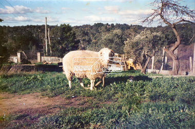
Photograph, Hans Gregory, Original 1860s William West house, Fabbro's Farm, Falkiner Street, Eltham, c.1990
Photos taken by Hans Gregory who along with partner Pauline Steele, rented the original old 1860s William West Cottage situated behind the Fabbro family home. Hans was employed as a Youth officer with the Shire of Eltham at the time and was the last tennant on the property. The property was sold and in 1995 was developed for residential housing as the Riverview Park estate. Guido Quarto Fabbro was born 21 August 1891 at Treppo Grande in the far northeast of Italy, the son of Giacomo Fabbro and Anna Geruzzi. Regina Moretti was born 6 March 1893 at Treppo Grande, Italy, the daughter of Giovanni Battista Moretti and Maria Teresa Coletti. Guido and Regina married about 1917 and they had two sons, Giacomo (John c.1918) and Maurie (c.1920). In 1925 Guido Fabbro departed his homeland from Genoa, arriving in Fremantle, Western Australia in June, travelling 3rd class aboard the ship, Caprera. Regina and their two boys followed a year later along with other family members arriving in Fremantle from Genoa 4 July 1926 aboard the Moncalieri. The Fabbros arrived in Eltham in 1933 and purchased a block of land from William West on the western side of Falkiner Street, extending to Ely and Porter Streets which had formerly been part of the West family orchard and dairy farm. As there was no fencing dividing the two properties, West served notice on Guido in December 1934 to bear half of the cost of £6. When payment was not forthcoming, West sued Guido in the Eltham Court in January 1935. Guido failed to appear and was not represented, and costs were ordered in West’s favour. Guido and Regina built a large Italianesque house on their property. The original 1860s cottage was relocated to the back of the block and was rented out (once to Alistair and Margot Knox). Guido also purchased land extending to the Diamond Creek on the eastern side of Falkiner Street and on the eastern side of Bell Street (opposite Eltham High School). The riparian soil was suitable for market gardening: Guido grew mainly tomatoes, but also pumpkins, cauliflowers, cabbages, peas, beans, lettuce, beetroot and zucchinis. Even the land surrounding the house was used. The produce was carted to Melbourne overnight for sale at the market. Guido died in 1970 and is buried in Eltham cemetery. Regina died 1986. She and their son John Patrick (Giacomo) Fabbro who died in 1984 are also buried at Eltham Cemetery. Guido’s son Maurie continued in his father’s footsteps until 2007, principally growing artichokes in later years. He died in 2009. The land on the eastern side of Falkiner Street now forms part of a Council reserve called “Barak Bushland”, the land on the western side having been sold off for residential subdivision. The Bell Street land is now public open space managed by Nillumbik Shire Council and called “Fabbro Fields”. There have been recent proposals to develop the site for sporting purposes or as a dog park or community garden. Provides an insight into early settler's farmhouses and farming property of the Eltham district.guido quarto fabbro, regina fabbro (nee moretti), william west, maurie fabbro, fabbro's farm, hans gregory, west family orchard, west dairy farm -
 Eltham District Historical Society Inc
Photograph, Fay Bridge, Toe-hold tree, Heritage Excursion, Killeavey, Laughing Waters Road, Eltham, November 2016
This scar or 'toe hold' tree fell over 50 yrs ago. It had died 50yrs before it fell and is estimated to be around 400 years old. It has a diameter of 1.3 m and is the only 'toe hold' tree in Nillumbik. Heritage Excursion - Killeavey Walk and Talk - Saturday 5th November Jane Woollard’s book Laughing Waters Road Art Landscape and Memory in Eltham devotes several chapters to the property Killeavey situated on the Yarra River at the end of Reynolds Road, Eltham. Jane has written about the natural history and indigenous history of the area and stories of the family who lived at Killeavey for many years. Killeavey was the home of Sir William Irvine, Victorian and Federal Parliamentarian and Supreme Court Judge. Later it was the home of his daughter Beatrice Morrison, a significant figure in the Eltham community. The original house was destroyed by fire and its replacement was demolished by Parks Victoria. Its sits high above the Yarra River and contains significant garden remnants. The surrounding bushland is valued for its significant plant communities. In September 2011 we visited Killeavey but without the benefit of the information more recently available from Jane’s research. We are fortunate that Jane will be joining us on this walk. There will be an extended stop at the house site for a discussion on the environment and history of the area. Inside the cover panels of Jane’s book is a reproduction of the complete artwork from ‘The Symbiogenesis Project: Laughing Waters 2011 by Aviva Reed and Paul Kalemba, as displayed in the Eltham Town Centre. This walk will start at 2 pm on Saturday 5th November at the corner of Laughing Waters and Overbank Roads. - EDHS Newsletter No. 230 October 2016fay bridge collection, 2016-11-05, activities, eltham, eltham district historical society, heritage excursion, kileavey, laughing waters road, parks victoria, cameron beardsall -
 Eltham District Historical Society Inc
Document - Property Binder, 836 Main Road, Eltham
Newspaper article: Was woman found in well put in it? Diamond Valley Local, 16 February 1954, story of wife of baker found in well before Burgoyne family purchased bakery. Newspaper article: Bakery goes ... locals protest, The Valley Voice, 18 July 1979, Joh Ebeli protests about planned destruction, history of building memories of Alistair Knox. Note on demolition of Eltham Bakery building, 1979, by Joh Ebeli who tried to save front of house with friend names Elwers. Photocopy newspaper article: Murder mystery at bakery, History comes to life for old building, 4 November 1979, Harry Burgoyne remembers his grandfather John James Thomas Neville Burgoyne bought bakery in 1896 at time of body found in well, bakery build 1860-1864, sold in 1921. Photocopy newspaper article: Public meeting called over Eltham restaurant proposal, Diamond Valley News, 4 October 1988, protests re proposal for motel and restaurant. Photocopy newspaper article: Fresh tales at an old mine, Diamond Valley News, 4 October 1988, Ausminde Pty Ltd applied for renewal of exploration licence at Old Tree Hill Mine, last mined by Stan Bone and Bill Wallace, photograph of Russell Yeoman at site. Photocopy of line drawing, The Bakery, by Joh Ebeli, 1978. Photocopy of photograph, Old Bakery, next to house built 1880. Photocopy of photograph with Old Bakery in background. On August 12, 1902, appearing before T. Smallman, Esq,. Police Magistrate, and Messrs. W. Duncan and W.J. Taylor, Justices of the Peace is Luther Haley, baker. Wilfred Henry Johnston, by his agent Stanley Ernest Elder had applied for a warrant of ejectment under the Landlord and Tenant Act 1890 against Luther Haley from the bakery premises at the corner of Main Road and York Street. From the evidence presented it is made known that Mrs Burgoyne of Eltham had purchased the property some months earlier from Mr Johnston, which consisted of a store and bakery establishment at Eltham occupied by Mr. Luther Haley, and whose lease expired some little time back, and up to the present time, Mr. Haley was not prepared to leave. He informed the court that he was unable to secure at Eltham a suitable house in which to carry on his business, but he was building a place near the railway station which he expected to be done in about three weeks time, at which time he would give up possession of the bakery. Mr Smallman informed the defendant, Luther Haley, that he would have to quit the premises in three weeks from the present date, and that a warrant of ejectment would be issued. However he also informed Mr Haley that he would order the warrant to lie in the office for three weeks from that date. The premises under construction refered to by Luther Haley in court were situated on the western side of Main Road, near the railway station slightly opposite present day Arthur Street. It was opened around September 1902 as a General Store, Bakery and Tea Rooms. In June 2024 Annie Hackrath shared a memory of living in the old bakery: "My husband and I lived in the old bakery for 18 months in 1978-9 , husband Geoff used the old bakery out the back as a wood workshop, making turnery and handcrafted furniture. The front shop was operated as a “sometimes” art gallery which we called “Gouge and Grain”. There were old sheds against the back fence which we thought were probably stables from the bakery days. Lovely memories of the old place which had so much character and seemed to attract a multitude of interesting creative people! Sad that it was pulled down; a friend salvaged some of the lead light glass in the old doors and included it in a new door panel for us."main road, eltham, property, shops, businesses, eltham bakery, burgoyne family, joh ebeli, alistair knox, harry burgoyne, john james thomas neville burgoyne, one tree hill mine, stan bone miner, bill wallace miner, russell yeoman, henry rech, ausminde pty ltd, john street, bridge street, judy paynter, art gallery, gouge and grain, annie hackrath, geoff hackrath -
 Eltham District Historical Society Inc
Photograph - Aerial Photograph, Landata, Eltham, Main Road; Henry St to Bellevue Rd, Dec. 1945
Eltham, Main Road; Henry St to Bellevue Rd, and east along Luck St to present day Eltham East School Historic Aerial Imagery Source: Landata.vic.gov.au Aerial Photo Details: Project No :5 Project : MELBOURNE AND METROPOLITAN AREA PROJECT Run : 36 Frame : 60549 Date : 12/1945 Film Type : B/W Camera : EAG4 Flying Height : 10200 Scale : 6000 Film Number : 228 GDA2020 : 37°42'45"S, 145°08'59"E MGA2020 : 336903, 5824465 (55) Melways : 21 K4 (ed. 42)aerial photo, arthur street, bellevue road, bible street, diamond street, dudley street, elsa court, eltham, eltham east primary school, gahan house, henry street, livingstone road, luck street, main road, pryor street, neil webster collection -
 Glen Eira Historical Society
Letter - O’Neill College, Nagle Avenue, 2, Elsternwick
2 articles related to O’Neill College. Photocopy of advertising leaflet for the auction of house- blocks, on the O’Neill College Estate, Elsternwick Auction held 08/04/1922. Copies of 4 letters dated 17/07/1936 to 12/04/1937 from the Victorian Public Health Dept. to the Mother Superior, O’Neill College, regarding alterations to the college buildings.o’ neill college estate, elsternwick, burke t. m., subdivisions, railway crescent, nagle avenue, denver court, robinson c.h., gardenvale railway station, presentation novitiate, auctions, catholic schools, convents, nuns, colleges, school houses, building construction, building permits, public health department, o'neill college, o'neill college estate, elsternwick railway stations, brentani avenue, caulfield city council -
Glen Eira Historical Society
Document - Hall, Hugh Percival
Typed biography on the life and times of Hugh Percival Hall, by his daughter Felicitie E. Campbell dated March 2006. He was a solicitor, artist and photographer and his grand-father built Glenmoore in St. George’s Road, Elsternwick.artists, hall hugh percival, caulfield grammar school, glenmoore, mansions, house names, ballet in australia from pavlova to rambert, photography, statues, watkin joyce leslie, moore hugh, hall felicitie elizabeth, campbell felicitie elizabeth, campbell andrew john egan, campbell carol, meares diugan and hall, ballet and dance, campbell alistair, campbell ross, campbell robyn, campbell lynette, glen eira road, steadman cameron meares and hall, tennis courts -
 Glen Eira Historical Society
Article - East Caulfield Park
This file contains two items about this Park. An article featuring Caulfield Park and East Caulfield Park, which was developed as the districts principal sporting areas, relating to development and restoration. Includes copies of four photographs relating to the parks featured. One colour photograph of the Park: undated, source unknown. Noted on reverse 'E. Caulf. Reserve Pavilion'.caulfield, caulfield park, east caulfield park, crown reserves, caulfield council, east caulfield park, committee of management, caulfield park committee of management, little harold, lidsey p. mrs., hannan lynette ms., leskie mr., caulfield sub district cricket club, caulfield lacross club, anderson sandy, michelson david, balaclava road, hawthorn road, victorian cricket association, cbc st. kilda, grimwade house, st. aloysius primary school, st. anthony’s primary school, monash university caulfield campus, committees of management, cypress trees, mahogany gym trees, parks and reserves, gardens, parks, sport, sports and recreations, leisure, cultural events, cultural activities, sportsgrounds, sports people, ovals, playing fields, sports establishments, recreations establishments, clubs and associations, associations, organisations, societies, athletic clubs, community groups, pavilions, playground equipment, playgrounds, gardens, barbecues, picnics, tennis courts, lawn bowls, bowls, bowling clubs, schools, educational establishments, trees, plants -
 Glen Eira Historical Society
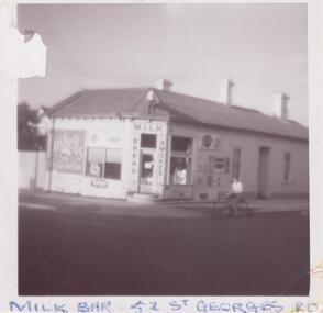
Photograph - ST. GEORGES ROAD, 52, ELSTERNWICK
Four items about this property: 1/Two typed research reports, dated 10/07/1987 and 12/03/1995, by Hilary Bullock and Rosalind Landells, regarding the history of ownership and occupancy of 52 St. Georges Road, Elsternwick and a description of the development of the building. Includes handwritten working notes, undated, for the 12/03/1995 report. 2/Handwritten file note from Sands and McDougalls from 1903 to 1948, giving occupiers' names and occupations. 3/A black and white photograph of the building as a milkbar plus a colour photograph dated 1982 of the milkbar. 4/Three photos and brief notes for auction of property in 2006 by Hocking Stuart. Dates for these advertisements are 08/11/2006 for one and 10/11/2006 for the other two.st. georges road, photographs, elsternwick, land subdivision, federation style, architectural styles, corner stores, drew alexander, shops, tennis courts, drew a., general stores, righetti mrs, grocers, righetti n, businesses, hodges edward, milkbars, flats, woodrow r miss, houses, geddings p., geddings w., business people, ogden s., brighton historical society, ogden a, landells rosalind, bright j.a., dowsing i, batagnol i., arnold h.t., batarol l., noel jones real estate agency, turner r., rand real estate pty ltd, nemeth f., noel jones real estate agency, serginis c., sergianis c., bullock hilary, timber houses, greengrocers, victorian style, stained glass -
Glen Eira Historical Society
Document - Tudor Court, Kooyong Road, 141, Caulfield North
Photocopy of a conservation study of Tudor Court by Andrew Ward dated January 1995. Includes description of architectural features, brief history and photograph of exterior of the house.caulfield, kooyong road, tudor court, knowsley, airdrie, holt frederick, ward andrew, holt annie, hope george, duffield lancelot, rippin john, mansions, architectural features, federation style, towers, chimneys, stairs, glen eira road, balaclava road, fairholme, fairhaven -
Glen Eira Historical Society
Document - Gunyah, Kooyong Road, 283, Elsternwick
A two page photocopy of a Caulfield Conservation Study by Andrew Ward, dated 09/1994, on the house Gunyah located at 283 Kooyong Road, Elsternwick. The study includes a brief history of the property, a description of the house’s architectural features, a statement of its significance and a photograph (100mm x 150mm) of the house exterior.gunyah, kooyong road, elsternwick, ward andrew, caulfield conservation study, elsternwick, caulfield, rothesay, italianate style, architectural styles, ricketson henry, prentice street, mount l l, morrison alan, cummins alfred, cumberland rose, mansions, villas, glen eira estate, calista court, hendra court, architectural features, city of caulfield -
Glen Eira Historical Society
Book - Hillcrest Estate Draft Heritage Guidelines July 2000
... Eumeralla Street 'Karkill' House names Cropmpton Court Booran Road ...2 items about Hillcrest Estate and heritage: 1/A 20 page report giving draft heritage guidelines by the City of Glen Eira for properties within the Hillcrest Estate Heritage Area of Caulfield South, including Hillcrest Avenue numbers 1 and 3-12 and Marara Road numbers 27 and 28. The Heritage Area has been assessed as noteworthy as 'the first housing estate developed by the AV Jennings Construction Co., later known as Jennings Group Limited.' Developed during the Depression years of the early 1930s, it is considered an 'unusually intact example of an interwar garden estate' and is also considered noteworthy for its aesthetic values. The Report describes typical features for two house forms typical of the area: the single-storey villa with decorative porch and the single storey villa with decorative verandah. It gives guidelines on the types of changes which can be made to houses within the Heritage Area. Included are photographs of typical houses and design features, maps, and diagrams showing acceptable zones for additions, amongst other Sections (eg. Key design checklist). 2/A three page photocopy taken from Andrew Ward's Heritage Study for The Hillcrest Estate Historic Area.hillcrest estate, glen eira heritage management plan, glen eira planning scheme, glen eira city council, hillcrest estate heritage area, hillcrest avenue, merri street, marara road, eumerella street, av jennings construction co, jennings group limited, caulfield south, jennings albert, brick houses, architectural styles, architectural features, housing estates, garden estate, heritage studies, glen eira city council, city of glen eira, draft heritage guidelines july 2000, glen huntly, vines william, gurney edward, eumeralla street, 'karkill', house names, cropmpton court, booran road, estate agents -
 Glen Eira Historical Society
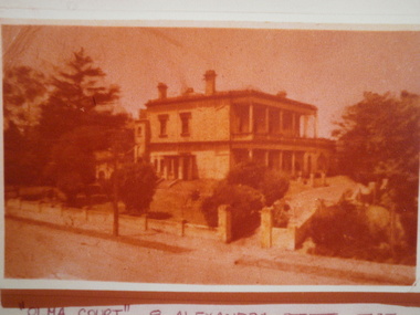
Photograph - Olma Court, Alexandra St, 8, St Kilda East
Three copies of one sepia photograph of external view of Olma Court as it looked like in early 1950s owned by LD Burns. Photographs from LD Burns collection donated by R Green grandson One black and white photograph of Olma Court dated on back 1955olma court, burns ld, green r, alexandra street, st kilda east, mansions, architectural features, house names, verandahs -
Glen Eira Historical Society
Document - Crotonhurst
Five pages of brief notes compiled by the Caulfield Historical Society about Crotonhurst. Provides details on the occupants of the house and the assessments of the house in different years.crotonhurst, langdon william farrar, langdon sophie sarah annie, langdon dottie, webb frank henry, webb george rupert, langdon william webb, langdon violet webb, langdon isobel, warburton-egerton frank, warburton-edgerton frank, crotonhurst avenue, anderson i v, hawthorn road, webb g h f, langdon w f, langdon sophie, mclaughlin j, land boom and bust, hydraulic machines, geo. fincham and sons, webb george henry frederick, supreme court judge, seelenmeyer adolphe dr, brammerton, bramerton, kamesburgh, mansions -
Glen Eira Historical Society
Document - Balaclava Road, 34, St Kilda East
A photocopy, 3 pages, of the Caulfield Conservation Study report on house formerly known as Noris, Quethiock and also Koala, located at Balaclava Road, 34, Caulfield, by Andrew Ward, dated 04/1993. Includes a description of the house, its condition, integrity, history, a statement of its significance, two black and white photographs (100mm x 70mm, 95mm x 70mm) of the house from different perspectives and a street map (160mm x 90mm) of the surrounding area with handwritten annotations.east louisa, alexandra street, balmoral court, beckwith thomas w, noris, quethiock, koala, wertheimer adolph, taunton james colonel, rosenhain oscar, rosenhain louise, victorian style, mansions, cuming william, ward andrew, cuming smith and co, johnson alfred, architectural styles, architectural features, balaclava road, ward andrew, st kilda east -
Glen Eira Historical Society
Document - Beauville Estate
Promotional material for the Beauville Estate Murrumbeena 65th Heritage Celebration held 10/03/2001. This comprises, a leaflet about the launch of the Glen Eira Heritage Draft Guidelines with features of the Estate and addresses listed, a special invitation to the unveiling of the heritage plaque by Glen Eira Mayor Veronika Martens, and a Leader newspaper advertisement dated 12/02/2001 for the event, giving brief history of shops and resident anecdotes by Bev Baxter of Murrumbeena Pharmacy.beauville estate, murrumbeena, lindsay avenue 40-44 (even), 229-233 murrumbeena road, beaville avenue, gloucester court, dalny road 5-25 (north side only), 232-242 murrumbeena road (even), glen eira heritage draft guidelines, murrumbeena pharmacy, a v jennings, 227-235 murrumbeena road, barker ann, martens veronica, baxter bev, heritage festivals, plaques, quinn miss, webb rosemary, webb roy, cleave edna may, quirk john, quirk eva, ritchie, kirkbride thomas, beauville, glen eira port phillip pulse small business awards 2000, architectural features, brick houses, shops, residential development, tennis courts, housing estates, builders, building regulations, local government, commercial development, children’s playgrounds, advertisements, invitations, pharmacies, grocers, dentists, greengrocers, butchery shops, sweet shops -
Glen Eira Historical Society
Document - Beauville Estate
Beauville Estate Draft Heritage Guidelines, July 2000, produced by the Glen Eira City Council, author unknown, 25 pages. The Guidelines set out design parameters, principles and techniques for achieving appropriate heritage conservation objectives for the defined Beauville Estate Heritage Area, to be used by the Council, property owners, residents and designers. A number of photographs of houses and design features are included in the document as well as a brief history of the Estate and a Key Design Checklist.a v jennings construction co, gurney edward, jennings albert v sir, beauville estate, beauville estate heritage area, beauville avenue 1-39 (odd), beauville avenue 2-36 (even), dalny road 3-25 (odd), gloucester court 1-3 (odd), gloucester court 2-6 (even), lindsay avenue 40-44 (even), murrumbeena road 227-233 (odd), murrumbeena road 222-232 (even), murrumbeena, glen eira city council, architectural features, architectural styles, plans, brick houses, shops, residential development, tennis courts, housing estates, builders, building regulations, local government, commercial development, history, maps, photographs -
 Eltham District Historical Society Inc
Photograph, The first houses in construction on the new Stokes Orchard Estate, July 1976, July 1976
... Close, Nyora Road, Peppermint Grove, Scarlet Ash Court, Stokes ...Viewed from near the Stokes family home at 1 Nyora Road looking northeast across Ironbark Close to Scarlet Ash Court with Peppermint Grove in the distance. Frank Stokes first traveled to the district by train in 1944 to find land with the intention to establish an orchard. By chance he met Arthur Bird of Bird Orchard (bounded by Pitt Street, Eucalyptus Road and Wattle Grove) and they got talking over their common interest. Arthur put Frank up for the night and pointed out the land, part of Crown Allotment 15, Section 5, Parish of Nillumbik (CA15) somewhat diagonally opposite Bird Orchard. Frank bought the land and for the next two years would travel by train from Melbourne to Eltham every weekend establishing Stokes Orchard and building a home for his family, which they eventually moved into in 1946. In the mid 1970s the Shire of Eltham divided the orchard up into numerous rate-able parcel lots, which became affordable for Frank. As a consequence Stokes Orchard was turned into a housing development by Macquarie Builders and marketed as the Stokes Orchard Estate in two stages; Stage 1 encompassing Scarlet Ash Court, Ironbark Close and Peppermint Grove bounded by Nyora and Eucalyptus roads c.1976 and Stage 2 encompassing Stokes Place, Orchard Way, The Crest and The Lookout bound by Nyora and Diosma roads c.1979. The development of Orchard Way, The Crest and The Lookout did not proceed as planned due to the lack of the sewer along Diosma Road and so many of the proposed lots were incorporated into five-acre parcels instead.Housing development in Eltham as an extension to the Woodridge EstateDigital file only - Digitised by EDHS from a scrapbook (containing commercially printed photos of digital scans) on loan from Beryl Bradbury (nee Stokes), daughter of Frank Stokes.1976-07, beryl bradbury (nee stokes) collection, building construction, ironbark close, nyora road, peppermint grove, scarlet ash court, stokes orchard estate, houses -
 Eltham District Historical Society Inc
Film - Video (DVD), Frank Stokes, Stokes Family, 1950-1977
Various family scenes taken from outside the family home on the southeast corner of the intersection of Nyora Road and Pitt Street with Eucalyptus Road. Also, scenes of the Stokes Orchard and equipment used, construction of water reservoir at the end of Nyora Road near Reynolds Road and Diosma Road as well as early stages of the Stokes Orchard housing development. Frank Stokes worked as a qualified accountant at Kennons leather factory in Burnley, while living at 1 Thomas Street, Mitcham. He suffered from migraines and wanted to go back to the land (he had previously worked on farms and orchards since coming to Australia in 1926 both in WA and Vic.). He first travelled to the district by train in July 1942 to find land with the intention to establish an orchard. By chance he met Arthur Bird of Bird Orchard (bounded by Pitt Street, Eucalyptus Road and Wattle Grove) and they got talking over their common interest. Arthur put Frank up for the night and pointed out the land, 158 acres- Taylor Estate- £900, part of Crown Allotment 15, Section 5, Parish of Nillumbik (CA15) somewhat diagonally opposite Bird Orchard. He applied through the Riverina Agency to purchase the land who in turn had to get permission from Canberra to sell as there was a new government regulation banning land sales except for immediate production. He obtained a loan on his Mitcham house of £600 @ 5% and paid £450 deposit with quarterly payments of £15 over 5 years. The title to the property was issued May 15, 1946. He was helped and advised by Arthur Bird who farmed the neighbouring orchard. Early 1943 he took possession and would catch the train out to Eltham on Fridays after work and began building a hut for shelter and to lock up tools. He was able to pay a neighbour (Hawkins) to help with clearing and fencing 25 acres and with a horse and single furrowed plow, planted approximately 2,500 fruit trees - cherries, peaches, plums, almonds, pears, apricots and lemons as well as a few apples and oranges; a massive job. A huge problem was hares and rabbits eating all the new buds off the tiny trees. As well as laying poison he painted the trees with a mixture of cow manure and lime. Often working by moonlight. It was extremely difficult to get wire and wire netting because of the war but after much effort he obtained a permit from the Agricultural Department for supplies in March 1944. In February 1945 he applied for a permit to build a “packing shed” as no house building allowed. It was to be 33 feet x 21 feet and cost £312. Constructed mostly from second-hand materials, which was hard to obtain, especially iron for roofing. Frank finished work at Kennons October 31, 1945, and in March 1946 he sold the Mitcham house for £1230 plus £170 for furniture. The family of five then moved into a very unfinished at Eltham, which was a struggle to weatherproof. Eventually rooms were divided off and lined with hessian bags and whitewashed. Their income was firewood (cut and sold), selling rockery stones and cut sweet bursaria. (It was discovered during the 1940s that Bursaria contained the sunscreen compound Aesculin. The RAAF utilised this compound from Bursaria during WW2 for pilots and gunners.) The orchard’s first fruit sale was a 1/2 case of Le Vanq peaches in December 1947 - 8 shillings. In 1956 plans for house were drawn and Glen Iris bricks purchased (1956 Olympic Rings variant). The building of the house commenced in 1957 - 12 feet of original packing shed removed – and was completed in 1959. Water was connected from newly built pressure storage on the property at the end of 1959 and the electricity connection for the first time at 3pm on April 29, 1960. In the mid-1970s the Shire of Eltham divided the orchard up into numerous rate-able parcel lots, which became unaffordable for Frank. Consequently, Stokes Orchard was turned into a housing development by Macquarie Builders and marketed as the Stokes Orchard Estate in two stages; Stage 1 encompassing Scarlet Ash Court, Ironbark Close and Peppermint Grove bounded by Nyora and Eucalyptus roads c.1976 and Stage 2 encompassing Stokes Place, Orchard Way, The Crest and The Lookout bound by Nyora and Diosma roads c.1979. The development of Orchard Way, The Crest and The Lookout did not proceed as planned due to the lack of the sewer along Diosma Road and so many of the proposed lots were incorporated into five-acre parcels instead. With the arrival of the sewer along Diosma Road many years later, most of these five-acre parcels have since been subdivided many times.Representative of the orchard growing areas of ElthamMP4 00:24:39; 426MB Digital file only - Digitised by EDHS from a DVD copy on loan from Beryl Bradbury (nee Stokes), daughter of Frank Stokes. 24 min duration compilation of home movie Super 8mm film shot by Frank Stokes brother-in-law.beryl bradbury (nee stokes) collection, frank stokes, nyora road, stokes orchard, stokes orchard estate, stokes place, video recording -
 Eltham District Historical Society Inc
Photograph, Looking southeast from Main Road at intersection with Brougham Street, c. September 1966, 1966c
View looking across the front grounds of the former Police Station towards the weatherboard building on the opposite corner of Brougham Street which was once used as a Doctor's surgery by Dr R. Bradbury in the 1930s. The property was known as Cooinda. The Bradbury family also owned the houses adjacent to Napoleon Street. Succeeding Dr Bradbury was Dr R.B. Loosli, resident from 1947 to 1961. The house was later developed into a series of restaurants, Marcella's in the 1980s/1990s, Gennaro's Pizza Restaurant 2010s, Franco Pizza, presently being Franco and Co.Black and white photographic printOriginally located in a Filmpro King Size Prints processing envelope $3.01 Shire of Eltham 9/9/66 and noted as Calrossie Ave area and crossed out Eltham-Yarra Glen Road, Bridge Street to Elsa Court existing conditions mid 1967brougham steet, franco and co, local history centre, main road, restaurants, road construction, streets, cooinda -
 Eltham District Historical Society Inc
Photograph, Brougham Street, Eltham, c. Sep. 1966
Taken from alongside the Justice Precinct looking east. In the distance on the right hand verge there is a large Eucalyptus tree with a branch growing out over the road. That tree still stands today and is outside No. 102. The two houses on the right are possibly numbers 94 and 96.Black and white photographic printOriginally located in a Filmpro King Size Prints processing envelope $3.01 Shire of Eltham 9/9/66 and noted as Calrossie Ave area and crossed out Eltham-Yarra Glen Road, Bridge Street to Elsa Court existing conditions mid 1967brougham street, eltham, infrastructure, road construction, roads -
 Eltham District Historical Society Inc
Photograph, Bridge Street, Eltham, c. Sep. 1966
Last house on right is No. 122. The three houses on right remain relatively original in present time, the two visible houses on left have been substantially altered or replaced. Bridge Street ended at this point but has since been further extended eastBlack and white photographic printOriginally located in a Filmpro King Size Prints processing envelope $3.01 Shire of Eltham 9/9/66 and noted as Calrossie Ave area and crossed out Eltham-Yarra Glen Road, Bridge Street to Elsa Court existing conditions mid 1967eltham, infrastructure, road construction, roads, bridge street -
 Eltham District Historical Society Inc
Document - Map, Doug Orford, Main Road, Eltham (c..1930s-1970s), c.2010
Map of Main Road with listings of all properties (shops/homes) from Mount Pleasant Road through to Pryor Street from the 1930s on to about the 1970sandrew store, andrews newsagency, arthur street, babe taylor house, bakery, barbers blue gum store, blue gum, boarding house, bootmakers cottage, bottle shop, bradford butcher shop, bradford house, bradley house, brdbury house, bridge street, brooker, brougham steet, brown blacksmith, browne's grocer, bryant, burgoyne post office, burgoyne's shop, capewell butcher shop, catholic church, catholic school, chandlers lolly shop, cheddar black, chiropractor, cockcroft, commercial bank of australia, copelands chemist, copelands dairy, d. hall house, dave lyon house, david lyon house, dr cordner, dr loosli, dr r. bradbury, dudley street, eltham, eltham bakehouse, eltham courthouse, eltham fire brigade, eltham living and learning centre, eltham pre-school, eltham railway station, eltham shire office, eltham station masters house, eltham war memorial, f. collis store, feed store, fountain hotel, franklin street, gadd's blacksmith, gahan house, garnet burges, george bird grocer, gollings, grant house, harry hawker, headmaster's resience, henry street, hepburn house, hills house, isherwood house and shop, jack ryan, jack shallard, james house, jarrold cottage, jim ryan, john lyon house, kilpatrick, le brocq, leather and harness, len parsons, lock-up, lyon bros garage, main road, map, mathews house, mclean's produce store, mechanics institute, methodist church, methodist hall, milkbar, mills bootmaker, miss george, monteith house, mount pleasant road, mrs bradbury, mrs davis house, mrs jewell, mrs mbremner store, mrs morris shop, napoleon street, obelisk, panther place, peter gahan, pitt street, plumber, police residence, poultry and market garden, pryor street, railway house, rains newsagency, real estate agent, reeves general store, s. bradbury, shillinglaw cottage, staffs general store, stones mixed shop, tennis court, timber yard, w. walker, w.b. andrew corn store, warren's general store, water trough, watsons hotel, websters house, whitecloud cottage, whites general store, williams bootmaker, wingrove cottage, wingrove park, woodyard, york street, franco and co -
 Eltham District Historical Society Inc
Slide - Photograph, Woodhaven Estate off Reynolds Road, Eltham, c.May 1988
The Age, Saturday, April 15, 1989, Page 72 OPEN SAT SUN 2-4 WOODHAVEN ESTATE A sample of house and land packages for your consideration: 3 br Ige rumpus $159,950 4 br tri level $169.9S0 4 br split level $169,500 Colonial with verandahs $199,950 Big 4 br dble garage $235,000 Huge exec 5 br S266.000 Meet our representative on site 2-4pm Sat and Sun in Booth Court, Eltham. off Reynolds Rd. Melway ref 22.E.335mm colour positive transparency (1 of 23) Mount - Kodak EktachromeProcess Date MAY 88Mmain road, eltham, housing estate, nicholas lauder real estate, woodhaven estate -
 Eltham District Historical Society Inc
Slide - Photograph, Incident Control Centre, Kangaroo Ground, Ness Lane and Kangaroo Ground-St Andrews Road, c.May 1988
The Age, Saturday, April 15, 1989, Page 72 OPEN SAT SUN 2-4 WOODHAVEN ESTATE A sample of house and land packages for your consideration: 3 br Ige rumpus $159,950 4 br tri level $169.9S0 4 br split level $169,500 Colonial with verandahs $199,950 Big 4 br dble garage $235,000 Huge exec 5 br S266.000 Meet our representative on site 2-4pm Sat and Sun in Booth Court, Eltham. off Reynolds Rd. Melway ref 22.E.335mm colour positive transparency (1 of 23) Mount - Kodak EktachromeProcess Date MAY 88Mincident control centre, kangaroo ground, kangaroo ground-st andrews road, ness lane -
 Eltham District Historical Society Inc
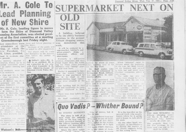
Newspaper clipping, Supermarket next on old site, Diamond Valley Mirror, Wed. Feb 17, 1965, p5, 1965
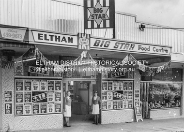
In February 1965, Staffs Railway Store, the oldest business premises in the Eltham shopping district was demolished. Formerly a self-service grocery, restaurant and electrical repair shop, the building for many years housed Eltham’s only ‘family’ grocer and feed store. Earlier it had appeared to have been the town’s bakery. The building had been purchased in late March 1939 by Mr Eric N. Staff. At the time of E.N. Staff’s purchase there were huge bakers’ ovens located at the rear and the building also had a well and four toilets for employees. When the ‘pictures’ came to Eltham with the opening of the Eltham Public Hall across the road in 1941, Mr E.N. Staff extended the business and opened a milk bar and sweet shop. Further extensions re-established the tea rooms of days gone by. Mr E.N. Staff conducted business for about 15 years before handing over the reins to his son, Ray Staff. When his son Ray took over, the milk bar and tea rooms were closed for several years but the milk bar and was later re-opened and subsequently became a greengrocers and later again, a restaurant. The tea rooms section was converted to an electrical repair shop about 1955. Electoral Roll records for 1967 record Raymond Charles Staff at 929 Main Road, Eltham, grocer, and in 1968 at Lot 4, Hillcrest Avenue, Eltham, taxi truck operator. So it would appear that Ray continued to run the business for approximately two years after the original store was demolished and a new supermarket was built. Today, 929 Main Road is the Nongkhai Thai Restaurant and is precisely where the original Staffs store stood. Even though the facade has been modified at eye level with new larger windows, the upper facade is identical to that of the new Eltham Big Star Food Centre of 1965/66. But how did the original building, the oldest premises in the 1965 era shopping centre come about? On August 12th, 1902 at the Eltham Courthouse, appearing before T. Smallman, Esq,. Police Magistrate, and Messrs. W. Duncan and W.J. Taylor, Justices of the Peace is Luther Haley, baker. Wilfred Henry Johnston, by his agent Stanley Ernest Elder had applied for a warrant of ejectment under the Landlord and Tenant Act 1890 against Luther Haley from the bakery premises at the corner of Main Road and York Street. From the evidence presented we learn that Mrs Burgoyne of Eltham had purchased the property some months earlier from Mr Johnston, which consisted of a store and bakery establishment at Eltham occupied by Mr. Luther Haley, and whose lease expired some little time back, and up to the present time, Mr. Haley was not prepared to leave. He informed the court that he is unable to secure at Eltham a suitable house in which to carry on his business, but was building a place near the railway station which he expected to be done in about three weeks time, and he is then prepared to give up possession of the premises he now occupies. Mr Smallman informed the defendant, Luther Haley, that he will have to quit the premises in three weeks from the present date, and that a warrant of ejectment would be issued. However he also informed Mr Haley that he would order the warrant to lie in the office for three weeks from that date. The premises under construction referred to by Luther Haley in court were situated on the western side of Main Road, near the railway station slightly opposite present-day Arthur Street. It was opened around September 1902 as a General Store, Bakery and Tea Rooms. This was the original building in the present-day shopping precinct. At the time the only thing nearby was the railway station. Luther Haley’s business appeared to prosper and he would have catered to not only the locals abut also day visitors by train on Sundays coming up from Melbourne, offering fresh baked produce, tea rooms and summer drinks. The fields across Main Road running between present day Arthur Street and Luck Street were known as Haley’s Paddock and at times were used for community festivities and picnics. A newspaper report on the annual State schools picnic held at Haley’s Paddock on March 11, 1904 described it as “quite close to the railway station, and is quite capable of holding comfortably 10,000 people. With its ample shade and hilly surroundings, it is an ideal place for any gathering.” Luther Haley successfully ran his general store, bakery and tea rooms until 1917 when he and his family departed the district and moved to Westgarth Street in Northcote where he changed careers and became a publisher. It was then taken over by Hannah Lloyd and became known as Lloyd’s Railway General Store from 1917 to 1920. From then it had a succession of owners, one as short as two months until March 31, 1939 when the Grocery Business formerly carried on by Mr. T.K. White of Eltham for the previous eight years was purchased by Mr Eric N. Staff of Research and became known as E.N. Staff’s Railway Store. The ownership timeline for the store is as follows: Luther Haley Sep 1902-1917 Hannah Lloyd 1917-c.Feb 1920 Messrs J.R. & N.E. Lee 1920-Sep 1922 A. & E. Copeland Sep 1922-Sep 1925 Mr Price Sep 1925-Nov 1925 Mr Warren Nov 1925?-Nov 1926 A.W.J. Edwards Nov 1926-1931 T.K. White 1931-Mar 1939 Eric Staff Apr 1939-c.1954 Ray Staff c.1954-Feb 1965 then demolished Ray Staff Eltham Big Star Food Centre c.1965-1967 Digital file only from scan of copy on loan to EDHSa. copeland, a.w.j. edwards, big star food centre, e. copeland, eltham, eric staff, general store, hannah lloyd, j.r. lee, lloyd's general store, luther haley, main road, n.e. lee, price, ray staff, staffs general store, supermarket, t.k. white -
 Eltham District Historical Society Inc
Photograph, Eltham Big Star Food Centre, Main Road, Eltham, c.1966
In February 1965, Staffs Railway Store, the oldest business premises in the Eltham shopping district was demolished. Formerly a self-service grocery, restaurant and electrical repair shop, the building for many years housed Eltham’s only ‘family’ grocer and feed store. Earlier it had appeared to have been the town’s bakery. The building had been purchased in late March 1939 by Mr Eric N. Staff. At the time of E.N. Staff’s purchase there were huge bakers’ ovens located at the rear and the building also had a well and four toilets for employees. When the ‘pictures’ came to Eltham with the opening of the Eltham Public Hall across the road in 1941, Mr E.N. Staff extended the business and opened a milk bar and sweet shop. Further extensions re-established the tea rooms of days gone by. Mr E.N. Staff conducted business for about 15 years before handing over the reins to his son, Ray Staff. When his son Ray took over, the milk bar and tea rooms were closed for several years but the milk bar and was later re-opened and subsequently became a greengrocers and later again, a restaurant. The tea rooms section was converted to an electrical repair shop about 1955. Electoral Roll records for 1967 record Raymond Charles Staff at 929 Main Road, Eltham, grocer, and in 1968 at Lot 4, Hillcrest Avenue, Eltham, taxi truck operator. So it would appear that Ray continued to run the business for approximately two years after the original store was demolished and a new supermarket was built. Today, 929 Main Road is the Nongkhai Thai Restaurant and is precisely where the original Staffs store stood. Even though the facade has been modified at eye level with new larger windows, the upper facade is identical to that of the new Eltham Big Star Food Centre of 1965/66. But how did the original building, the oldest premises in the 1965 era shopping centre come about? On August 12th, 1902 at the Eltham Courthouse, appearing before T. Smallman, Esq,. Police Magistrate, and Messrs. W. Duncan and W.J. Taylor, Justices of the Peace is Luther Haley, baker. Wilfred Henry Johnston, by his agent Stanley Ernest Elder had applied for a warrant of ejectment under the Landlord and Tenant Act 1890 against Luther Haley from the bakery premises at the corner of Main Road and York Street. From the evidence presented we learn that Mrs Burgoyne of Eltham had purchased the property some months earlier from Mr Johnston, which consisted of a store and bakery establishment at Eltham occupied by Mr. Luther Haley, and whose lease expired some little time back, and up to the present time, Mr. Haley was not prepared to leave. He informed the court that he is unable to secure at Eltham a suitable house in which to carry on his business, but was building a place near the railway station which he expected to be done in about three weeks time, and he is then prepared to give up possession of the premises he now occupies. Mr Smallman informed the defendant, Luther Haley, that he will have to quit the premises in three weeks from the present date, and that a warrant of ejectment would be issued. However he also informed Mr Haley that he would order the warrant to lie in the office for three weeks from that date. The premises under construction referred to by Luther Haley in court were situated on the western side of Main Road, near the railway station slightly opposite present-day Arthur Street. It was opened around September 1902 as a General Store, Bakery and Tea Rooms. This was the original building in the present-day shopping precinct. At the time the only thing nearby was the railway station. Luther Haley’s business appeared to prosper and he would have catered to not only the locals abut also day visitors by train on Sundays coming up from Melbourne, offering fresh baked produce, tea rooms and summer drinks. The fields across Main Road running between present day Arthur Street and Luck Street were known as Haley’s Paddock and at times were used for community festivities and picnics. A newspaper report on the annual State schools picnic held at Haley’s Paddock on March 11, 1904 described it as “quite close to the railway station, and is quite capable of holding comfortably 10,000 people. With its ample shade and hilly surroundings, it is an ideal place for any gathering.” Luther Haley successfully ran his general store, bakery and tea rooms until 1917 when he and his family departed the district and moved to Westgarth Street in Northcote where he changed careers and became a publisher. It was then taken over by Hannah Lloyd and became known as Lloyd’s Railway General Store from 1917 to 1920. From then it had a succession of owners, one as short as two months until March 31, 1939 when the Grocery Business formerly carried on by Mr. T.K. White of Eltham for the previous eight years was purchased by Mr Eric N. Staff of Research and became known as E.N. Staff’s Railway Store. The ownership timeline for the store is as follows: Luther Haley Sep 1902-1917 Hannah Lloyd 1917-c.Feb 1920 Messrs J.R. & N.E. Lee 1920-Sep 1922 A. & E. Copeland Sep 1922-Sep 1925 Mr Price Sep 1925-Nov 1925 Mr Warren Nov 1925?-Nov 1926 A.W.J. Edwards Nov 1926-1931 T.K. White 1931-Mar 1939 Eric Staff Apr 1939-c.1954 Ray Staff c.1954-Feb 1965 then demolished Ray Staff Eltham Big Star Food Centre c.1965-1967 Research and copy: Peter Pidgeon (EDHS) Digital file only from scan of copy on loan to EDHSa. copeland, a.w.j. edwards, big star food centre, e. copeland, eltham, eric staff, general store, hannah lloyd, j.r. lee, lloyd's general store, luther haley, main road, n.e. lee, price, ray staff, staffs general store, supermarket, t.k. white -
 Eltham District Historical Society Inc
Photograph, Belle Vue, Livingstone Road, Eltham, c.1960, 1960c
Photo taken at time of ownership by Eric Staff. Originally purchased by pioneer Eltham farmer Henry Stooke, Belle Vue farm comprised about 56 ha (140 acres) extending northerly from the northern boundary of Holloway’s 1851 Little Eltham subdivision. On the present day map the southern boundary was just north of Elsa Court and Grove Street. The western boundary was the Diamond Creek and extended northerly to Main Road where it turns easterly towards Research. It was traversed by the main road to Kangaroo Ground and beyond and from 1912 by the railway to Hurstbridge. From 1895 the farm was owned by William Williams and his wife Mary Ann. In 1914-1915 they built a new house now known as “Belle Vue”. They sold the land in 1920 and residential subdivision began soon after that. “Belle Vue” remains today on a large residential lot in Livingstone Road. The house and many old trees on the site have been subject to a heritage overlay under the Nillumbik Planning Scheme. Despite that overlay, most of the heritage trees were removed during sub-division and development of the property.Digital file only from scan of copy on loan to EDHSbelle vue, eltham, eric staff, houses, livingstone road, staff family -
 Eltham District Historical Society Inc
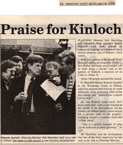
Drawing - Newspaper clipping, Praise for Kinloch, Diamond Valley News, April 8, 1998, p11, April 1998
PLANNING Minister Rob Maclellan and Nillumbik Shire president Robert Marshall have both praised an innovative housing development on a historic property east of Eltham's town centre. Both were present at the launch of the Kinloch Gardens development, where 12 new double and triple storey homes will be built along a private road in the gardens of Kinloch, a mansion set on 2.4ha in Arthur St. About 100 people attended the launch. Cr Marshall likened Kinloch Gardens to the Woodridge Estate at Eltham, which he said provided housing on small allotments while protecting much of the tree canopy, and "showed how a suburb can be built". He said Kinloch could easily have been subdivided, with a court running up the middle of the development, but the owners, the Jelbart family, opted instead for a private road on the property, sweeping around a common pond and 'village green'. ''This is a perfect example of what can be achieved in urban planning,'' he said. Mr Maclellan said the development was one of the most impressive he had seen in his role as Planning Minister Picture - Historic launch: Planning Minister Rob Maclellan (left) on a visit to Eltham last week to help launch a new housing development.Digital file only; created from scan undertaken by EDHS of item on loanarthur street, eltham, graeme gunn, houses, ian jelbart, jelbart property, kinloch gardens, rob maclellan, robert marshall, woodridge estate -
 Eltham District Historical Society Inc
Photograph, Ancona Court, Eltham, 1 July 1972, 1972
Housing estate development prior to houses being constructed. New narrow road with roll over kerb treatment35mm colour positive transparency blue Agfacolour Service plastic mountancona court, eltham, infrastructure, streets -
 Eltham District Historical Society Inc
Photograph, George Coop, Single Motor Carriage (Red Rattler) Tait train, possibly 471M, heading for Eltham near Allendale Road, Diamond Creek, c.December 1980, 1980
View is looking northwest from the hillside just north of Allendale Road. The long rectangular house in the upper left is No. 22 Challenger Street, Diamond Creek, right at the sharp turn into Price Court. On the track in the straight section heading northwest are two small bridges where the track crosses the Diamond Creek, each fitted with derailment guard rails to prevent severe derailments should a train come off the tracks whilst crossing the culverts. Digital TIFF file Scan of 35mm Ilford FP4 black and white transparency471m, allendale road, challenger street, derailment guard rail, diamond creek, hurstbridge line, price court, red rattler, red rattler single carriage, single motor carriage, tait train