Showing 2281 items matching " damage"
-
 Flagstaff Hill Maritime Museum and Village
Equipment - Boat Fenders, 20th century
Boat fenders are designed to protect against damage caused by boats, docks or moorings knocking into other objects. The Coir boat fenders can absorb the impact, acting as a bumper. The design is similar to fenders used for narrow boat fenders or on canal boats, barges, workboats and moorings. Feners are available in round and oblong boat shapes in many sizes today.Fenders are marine equipment used to protect the sides of water vessels and to buffer them against daming from their moorings or each other. The knot and rope work used to make the covers of these fenders is a skill learned by many mariners and passed down through generations. Seafarers on 18th-to-20th-century sailing ships found many uses for this handcraft.Fenders, set of four; balls made from Coir or hessian material and covered with knotted rope. Each has a rope loop..warrnambool, shipwreck coast, flagstaff hill, flagstaff hill maritime museum, flagstaff hill maritime village, fender, knotted rope, buffer, coir, rope fender, round fender, boat protection, marine equipment, handmade fender, rope work, knot making -
 Otway Districts Historical Society
Transport, Remains of Airspeed Oxford aeroplane, 12 April 1942
Leaving Point Cook airbase conducting a low visibility cross-country flight at 11.05 am on 12 April 1942 an A25 Airspeed Oxford crashed 5 kilometres from Beech Forest. The pilot, Sergeant T.W. Penn, and two pupils, LAC R.E. Johnston and LAC J.R. Black, were killed. The airframe and engine were extensively damaged.Two pieces of crumbled aluminium metal and one piece of solid black rubber recovered from an Airspeed Oxford aeroplane.beech forest; plane crash; airspeed oxford; world war 2; -
 Buninyong & District Historical Society
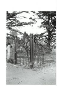
Photograph - Original B/W Photograph, Mr Clive J Brooks, Buninyong Cemetery gates, 9/4/1994
Cast iron gates commissioned from foundry at Castlemaine, for entrance to Buninyong Cemetery, Midland Highway. One pedestrian gate, one double gate. Gates acquired 1894. Originally olive green, gold-tipped spears. Painted white 1930s - 1940s. Damaged c1985, repaired by Mr Ron Nicholls, Buninyong. Repainted olive green 1992.Historically significant original gates acquired 1894.Buninyong Cemetery cast iron gatesbuninyong cemetery, gates, cast iron -
 St Kilda Historical Society
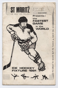
Ephemera - Program, Ice Hockey Fixture 1981, 1966
Ice hockey fixture for 1981 at St Moritz Ice Skating rink, Upper Esplanade St Kilda. Includes fixtures for the National Ice Hockey League and the Victorian Ice Hockey Association. The St. Moritz Ice-skating Palais (its original name) opened in 1939 and operated until 1981. The building was damaged by fire and demolished soon afterwards. White coloured card, folded into three, printed in black with an illustrations of ice hockey players on the frontst moritz, ice hockey, victorian ice hockey association, national ice hocky league -
 Canterbury History Group
Photograph - Demolition of Theatre in Maling Road, 1992
The Maling Road theatre was badly damaged by fire in 1990 and demolished in 1993. Built as a Hoyts Theatre in 1942 it later became the New Canterbury Ballroom and in 1971 the Immanuel Revival Centre. Part of a set of 8 coloured photographs taken by Jan Pigot to record the demolition of some shops and the old theatre to make way for new shops in Maling Road.Colour photocanterbury, maling road, maling theatre, new canterbury ballroom, immanuel revival centre -
 Flagstaff Hill Maritime Museum and Village
Document - Navigation Chart, Admiralty Office, Lady Bay and Warrnambool Harbour, 1893
This navigation cart of Lady Bay and Warrnambool Harbour was originally surveyed in 1870 but this version includes the update for magnetic variation in 1893. Since the printing of the chart several annotations have been added. These include an additional stamp dated 15-8-1910, a handwritten comment across the top of the page dated August 1910, and another handwritten comment regarding the ‘Proposed Extension of Dock’ dated 19-2-1925, plus connected drawings, notes and figures. The 1925 proposal on this chart may have been a reaction to the Royal Commission of 1923, when the damaged stonework on the seaward side of the Warrnambool Breakwater, caused by the action of the sea, was the subject of enquiry. A conference between the Public Works, Water Commission and the Harbour Trust concluded that it would less costly to make repairs to prevent further damage rather than replaced the damage portion of the wall. A contract was raised in late 1924 to deposit rubble on the damaged side of the breakwater to minimise the Southern Ocean’s destructive action and work had started by August 1925. The Breakwater construction had begun in 1874 and was completed in 1890. The Victorian Government had commissioned Sir John Coode, a British harbour engineer, to present a plan to complete the Warrnambool Breakwater but his original plan was too expensive. He prepared a revised plan for a shorter structure. The construction proved to be too short to protect adequately from the weather and didn't allow enough depth for larger vessels to come into port. The decreasing trade was further affected by siltation in the bay due to the breakwater, and the completion of the railway line. The situation of the harbour became a real problem by 1910 and required continuous dredging. In 1914 the Breakwater was extended but proved to be a failure because the work began to subside and by 1920 about two thirds of the harbour was silted up. Alterations made in the 1920's increased the silting problem and by the 1940's the harbour was no longer used. More alterations were made in the 1950's and 1960's. This chart is significant for its strong connection to the maritime history of Warrnambool Harbour and Lady Bay and the Warrnambool Breakwater. The Warrnambool Breakwater is registered as a place of significance on the Victorian Heritage Database (VHR H2024). The Warrnambool Breakwater is one of the most important late 19th century maritime engineering projects in Victoria and significant in the development of Victorian coastal shipping. It is also significant for its connection with British harbour engineer, Sir John Coode. The chart is a historical record of structures existing in 1893; the Warrnambool Jetties, Warrnambool Breakwater in Lady Bay, the leading lights (lighthouses), streets, roads, bridges and many buildings. It also shows the lay of the land and seabed. Navigation Chart: Lady Bay and Warrnambool Harbour, Australia - South Coast - Victoria. Surveyed by Nav. Lieut. H.J. Stanley, R.N., 1870. Updated for Magnetic Variation, 1893. The rectangular chart is printed on heavy cream paper. Stamps are shaped rectangular, oval and round. Around the Breakwater and Jetty area are handwritten notes, dotted and joined lines, numbers and signatures, and shading of red and green. The chart shows the surrounds of Warrnambool Harbour, Lady Bay, the Breakwater and Jetty, roads, bridges and the streets in Warrnambool. It has sounding details, and angles of line from the leading lights.Stamp, rectangular, including "AUG 1910" Stamp, double oval " - - - -CHART" Stamp, hand drawn, red circle, with "B" inside Hand written note "22-8-1910 - - - - - of surveying C. Ca - - - request of 15-8-10 [initials] " Notes and lines in red pen, including a grid of sounding numbers: "1300" "1050" "1200" "Possible Extension of Dock" "19-2-25" "Dock Dredged to 20 Ft" Notes and lines in blue pen "Extension of Dock to accommodate vessels drawing 20 Feet" and "Light not visible south of this line" Red dots (4) with yellow highlight at both leading lights, breakwater and jettyflagstaff hill, warrnambool, flagstaff hill maritime museum & village, maritime museum, maritime village, shipwreck coast, map, chart, navigation chart, plan, lady bay, warrnambool harbour, port of warrnambool, breakwater, jetty, pier, dock extension, proposed extension, vhr h2024, 1870, 1893, 1910, 1925, warrnambool town late 1800s, warrnambool streets late 1800s royal commission, 1923, public works, water commission, harbour trust, victorian harbours, sir jon coode -
 Bendigo Military Museum
Postcard - POSTCARD - WW1 FRANCE, cWW1
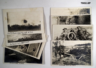
Part of the "Robert H. Baron", No. 3596 and Cooper Collection. See Cat, No. 1981P for details of Baron's service.1. Black and white photograph featuring burning and destroyed buildings. 2. Black and white photograph featuring horses and wagons with uniformed handlers. Ruined buildings in background. 3. Black and white photograph featuring a shell damaged two story building. Splintered trees in foreground. 4. Black and white photograph of a WW1 battlefield. Three waterfilled shell holes in foreground. Soldiers in background on horizon. 5. Black and white photograph of three soldiers in uniform standing next to a ruined cannon. 6. Black and white photograph of three soldiers in uniform standing next to the barrel of a canon. Soldier in uniform inside the mouth of cannon. 7. Black and white photograph of the surrounds of a ruined building. Statue of a human figure surrounded by metal fence in foreground. 8. Black and white photograph of a bomb damaged church. Rubble in foreground.1, Handwritten in black on front bottom and on back in pencil: 'Fritz Burning village of Ham before leaving.' 2. Handwritten in black on front bottom and on back in pencil: 'Entrance to Langacourt.' 3. Handwritten in pencil on front and back: 'Langacourt Chateau.' 4. Handwritten in black ink on front and in pencil on back: 'Passendaele Ridge.' 5. Handwritten in black ink on front and in pencil on back: 'Captured gun at Cappy.' 6. Handwritten in black ink on front and in pencil on back: 'Cappy.' 7. Handwritten in pencil on front and back: 'Bullecourt Church.' 8. Handwritten in pencil on front and back: 'Viller Brettoneaux Church.'robert h. baron, cooper collection, postcard, ww1, france, battlefields -
 Melbourne Tram Museum
Photograph - Black and White photograph, mid to late 1970's
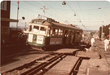
Set of five colour prints of tram W5 725 derailed in High St Kew during track reconstruction work at the corner of Derby St Kew. Tram was bound for North Balwyn when it derailed on a section of track that had been dismantled, possibly when it hit or dislodged a track crossover. Tram has advertisements for Bonds, Tollana Wines, Park Drive cigarettes, .1 - tram derailed at the top of the hill down to Kew Cemetery. .2 - with workmen setting up the tram and place on the temporary transport wheels. The second axle box towards the drop centre is on an angle compared to the nearest axle box. .3 - close up view of the damaged truck. .4 - General view of the scene looking back towards Kew Junction. .5 - view of the damaged crossover section. Date: during the 1970's.trams, tramways, accidents, derailments, kew, high st, north balwyn, route 48, temporary track, tram 725 -
 Melbourne Tram Museum
Photograph - Framed Photographs, Stewart Merritt, 1982 or 1983?
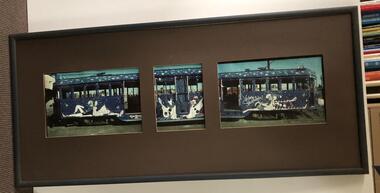
Framed three part photograph of tram W2 439 painted by Stewart Merritt, showing the tram along its length. Each photograph along the length of the tram individually presented, but not necessarily lining up. The original prints were scanned and reprinted, but they continue to show the damage. Frame wooden frame, with paper backing and wire hanging strips, clips and felt bumpers in the bottom corners. Was originally framed with a wood half round section, painted brown, glazed, with non-acid free cardboard surround and paper backing but has suffered extensive water damage both to the cardboard and the individual photographs themselves. The photographs were in a deteriorated condition. The item was unglazed at the time of the donation. The Museum had the photographs rescanned and remounted. For the original photographs see Reg Item 4213i1 to 4213i3. Framing work by "Framed by You" in Church St Richmond.trams, tramways, transporting art, ministry for arts, w2 class, tram 439 -
 Cheese World Museum
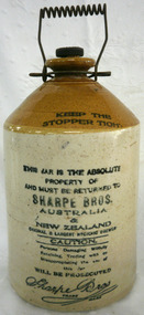
Jar, stoneware
This jar was used by the Hunt family on their dairy farm at Cudgee.Stoneware jar with stopper and wire handle. The cream body has instructions for use. From where the bottle slopes to the stopper is glazed brown. The stopper is rubber and the handle coiled wire.Stopper: 'Sharpe Bros Australia and New Zealand'. Body: Keep the Stopper Tight. This Jar is the absolute property and must be returned to Sharpe Bros. Australia & New Zealand Original and Largest Hygenic Brewer CAUTION. Persons Damaging Wilfully Retaining, Trading with or Misappropriating the use of this jar WILL BE PROSECUTED Sharpe Bros Trademarkallansford, cudgee, mervyn hunt, sharpe bros, stoneware jars, dairy farming, bottles, china ware -
 Orbost & District Historical Society
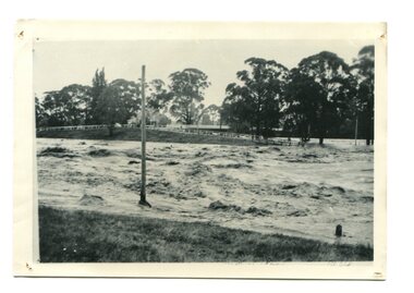
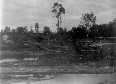
black / white photograph, January 1934
Damage estimated at £500,000 was caused by the 1934 floods in the Orbost district. This 1934 flood was devastating, destroying a section of the 1922 Orbost bridge, wrecking fences, bridges and roads, dumping silt and debris on the rich river flats and drowning cattle. This photograph shows Lochiel Lagoon ( the billabong) in the foreground. Ten minutes after this photograph was taken, the centre span of the Orbost Bridge was washed away.This item is a pictorial record of the 1934 floods, a significant part of Orbost's history.A black / white photograph of swirling floodwaters with township in the background.orbost-floods-1934 natural-disasters-floods -
 Eltham District Historical Society Inc
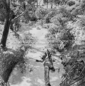
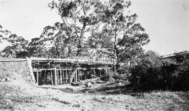
Album - Photograph, J.A. McDonald, Eltham-Diamond Creek Road, 21 Sep. 1959
After some delay in receiving funds, work started on the bridge approaches in early September 1959. Traffic was still using the old bridge upstream. On Sunday, 20 September 1959, heavy flooding occurred in the stream and at 3:53 pm the old bridge was washed out. This photo was taken the day after. Here is what did the damage lying between the two bridges.Record of various Shire of Eltham infrastructure works undertaken during the period of 1952-1962 involving bridge and road reconstruction projects, sometimes with Eltham Shire Council Project Reference numbers quoted. It was during this period that a number of significant improvements were made to roads and new bridges constructed within the shire that remain in place as of present day (2022). In many situations, the photos provide a tangible visible record of infrastructure that existed throughout the early days of the Shire. The album was put together by or under the direction of the Shire Engineer, J.A. McDonald.infrastructure, road construction, shire of eltham, bridge construction, bridge, diamond creek (creek), eltham, eltham north, glen park bridge, wattletree road bridge, 1959-09-21 -
 Kiewa Valley Historical Society
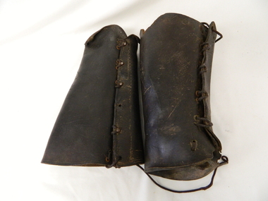
Gaiters Riding, Late 19th Century
These gaiters where used circa 1800's to mid 1900's, by horse riders "cattle men" to protect their shins and long trousers against wear and tear. They were used rather than having expensive boots damaged. Gaiters were a lot easier to fasten and clean than boots. They were used in the Kiewa Valley and the High Plains grazing areas.These gaiters were part of a cattleman's "out fit". The Gaiters were easily cleaned and did away with expensive riding boots. They were used throughout the valley and high plains areas both by horse riders herding cattle and the recreational rider of both sexes. After the 1950s more recreational riders from Melbourne ventured onto the high plains and not so rugged mountain slopes. Small settlements such as Mount Beauty, Bogong village and Falls Creek provided a secure backdrop for short term horse back adventures. The increasing pressure of city life provided a greater flow of stressed out city dweller to find the peace and quiet that city life does not have. Horse riding preceded the modern trail bikes and other recreational vehicles of the late 1900s. Thick leather tapered gaiters with six metal Hooks and Leather lacing through metal eyelets. All bar two eyelets have a metal reinforced punch holes. Left gaiter missing most of lacing.horse, country, leather, gaiters, high, grazing, cattlemen, laces, studs -
 Ballarat Heritage Services
Image, Wilson Hall, Melbourne University
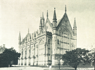
The first Wilson Hall was the gift of Sir Samuel Wilson, who offered the University £30,000 in 1874 for this purpose. Building strated in 1878 and the hall was opened in 1882. It was designed in the Perpendicular Gothic style by Joseph Reed, constructed in stone and built on a very generous scale. In 1952 Wilson Hall was damage by fire, and a new hall was built on the site. The original Wilson Hall was destroyed by fired. Black and white photograph of Wilson Hall, a building in University of Melbourne. It was built in 1890 by Fincham & Hobday. wilson hall, university of melbourne -
 Tarnagulla History Archive
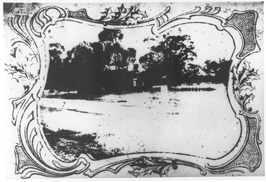
Photograph: Debris after flood, Newbridge, Debris after flood, Newbridge, 1909 (original image)
On 20th August, 1909 the Laanecoorie Weir broke away and released 18.3 million cubic metres of water through the opening and causing severe damage to all towns downstream. At Newbridge, Petersen's bakery collapsed and Simpson's Store and Hotel flooded to the roof. The billiard table was later found in a tree five miles down the Loddon near Learmonth. Murray Comrie Collection. Monochrome photograph, image depicting debris in the area near Loddon River at Newbridge after major flood in 1909. This is a very dark copy of an older original. Copy probably made by Murray Comrie in the 1960s.newbridge, loddon river, flood -
 Tarnagulla History Archive
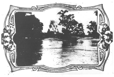
Photographs: Loddon River, Newbridge after flood, Loddon River, Newbridge after flood, 1909 (original image)
On 20th August,1909 the Laanecoorie Weir broke away and released 18.3 million cubic metres of water through the opening and causing severe damage to all towns downstream. At Newbridge, Petersen's bakery collapsed and Simpson's Store and Hotel flooded to the roof. The billiard table was later found in a tree five miles down the Loddon near Learmonth. Murray Comrie Collection. Two copies of a monochrome photograph, image depicts the area near Loddon River at Newbridge after major flood in 1909. This is a very grainy and dark copy of an older original. Copy probably made by Murray Comrie in the 1960s.newbridge, loddon river, flood, bridge -
 Tarnagulla History Archive
Photographs: Loddon River, Newbridge after flood, Loddon River, Newbridge after flood, 1909 (original image)
On 20th August,1909 the Laanecoorie Weir broke away and released 18.3 million cubic metres of water through the opening and causing severe damage to all towns downstream. At Newbridge, Petersen's bakery collapsed and Simpson's Store and Hotel flooded to the roof. The billiard table was later found in a tree five miles down the Loddon near Learmonth. Murray Comrie Collection. Two copies of a monochrome photograph, image depicts the area near Loddon River at Newbridge after major flood in 1909. This is a very grainy and dark copy of an older original. Copy probably made by Murray Comrie in the 1960s.newbridge, loddon river, flood, bridge -
 Federation University Historical Collection
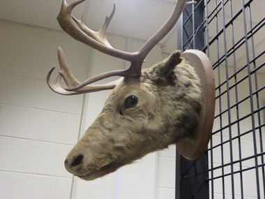
Object, Mounted Caribou (Rangifer tarandus)
This specimen possesses asymmetric brow tines, one of which is palmate. This flattened tine is commonly referred to as a "shovel," and is a typical feature of reindeer. It is not found in other cervids. The nose of red deer is also bare and leathery (like that of a cow), while the nose of reindeer is covered with hair, as is the case with this specimen. There appears to be a small patch of damage where the hair has been rubbed off. taxidermy, stuffed animal, deer, ten pointer, antlers, caribou, reindeer, rangifer tarandus -
 Bendigo Historical Society Inc.
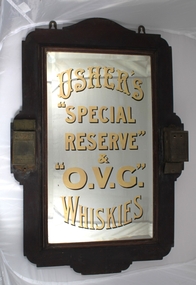
Sign - Pub Sign, 1920
The sons of a spirits dealer, Andrew and John Usher created one of the world’s most successful blended Scotch whiskies, Old Vatted Glenlivet, and played a key role in building the North British distillery. But they were also responsible for one of the most misunderstood lawsuits in Scotch history – the trademark battle for ‘Glenlivet’. Iain Russell reports. Three badly damaged paper labels on the back. A mirror is mounted on a one centimetre thick, 67 by 43 centimetres wooden frame with 18 centimetres by three centimetres decorative extensions on all sides. there two pieces of metal on the top to hang the mirror. A box nine six by four centimetres is mounted on each side, one is labeled MATCHES and the other CIGAR CUTTER both have ANDREW USHER & Co written on them. Behind the glass is gold coloured writing with black shadows stating USHER'S "SPECIAL RESERVE" & "O.V.C." WHISKIESpub mirror, andrew usher, o.v.c. whiskies -
 Bendigo Historical Society Inc.
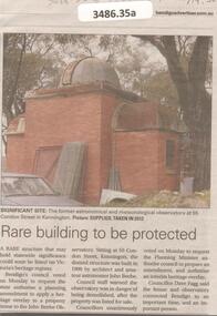
Newspaper - Articles on the former Observatory, 2024
The City of Bendigo asked for a heritage overlay over the site of a private Kennington observatory. It was once used for for the City's official meteorological readings. The observatory was built by architect John Beebe and is on the storm damaged property part of "La Rocca" house. Council approved $2 million for preservation of the site which will be integrated into a contempory complex boasting seven childcare rooms for 144 children.Bendigo Advertiser and the Herald sun: five articles on the former astronomical observatory at 55 Condon Street in Kennington.bendigo, observatory, john beebe -
 Phillip Island and District Historical Society Inc.
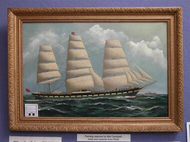
Painting - Painting, framed, The Speke, 1891
The ship Speke ran aground on the coast of Phillip Island on the 22nd of February 1906. The ship was painted by Artist Woolston L Barratt in 1891 and hung in the saloon of the Speke. It was given by Captain Tilston to John Cleeland, captain of the rocket rescue team and the painting used to hang in his home Wollomai house on Phillip Island. It was restored by Mal Campbell to fix smoke damage.The Speke was an all steel ship built in Wales in 1891, the second largest 3-masted full-rigged ship in the world. She was delivering wheat to Geelong and confused a bushfire in Cowes for navigation lights. Many local people salvaged goods from the resulting wreckage.Restored painting of the Speke mounted in the original gold frame.phillip island, art, speke, woolston barratt, woolamai house -
 Ithacan Historical Society
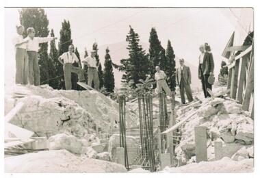
Photograph, Earthquakes: Rebuilding Church of Taxiarchon, Ithaca, 1953
The earthquake in 1953 which reached 7.2 on the Richter Scale caused extensive damage and devastation across the island of Ithaca. Entire villages were totally destroyed and a committee was formed to rebuild the beautiful Church of Taxiarchon which is located on top of Monastery Hill and overlooks the village of Platrithia. It was totally destroyed in the earthquake but is now considered to be one of the most beautiful churches in the Ephtanese group of islands.A black and white photograph of seven men standing around a work site and discussing aspects of a project. A trench with upright steel bars are in the middle of the construction work with soil and rubble heaped on either side. A stamp in Greek is on the back of the photograph. Translation is as follows: Committee rebuilding the Sacred Holy Church of Taxiarchon. Platrithia, Ithaca. earthquakes, church of taxiarchon -
 Eltham District Historical Society Inc
Negative - Photograph, Construction of the new concrete bridge over the Diamond Creek on Main Road, Eltham, c.May 1926
Construction of the new concrete bridge over the Diamond Creek on Main Road, Eltham, c.May 1926. Viewed from present day Wingrove Park. The original long suspension bridge over the Diamond Creek on Main Road at Eltham collapsed during flooding of the Diamond Creek on October 13 and 14, 1923. The original bridge was built around 1840 for the coach road when Cobb & Co.'s coach was the only conveyance between Eltham and Melbourne. Widespread damage was done in Melbourne and surrounding areas by floods resulting from the overflow of the Yarra at many points along its banks. A temporary bridge rigged up was severely damaged by the flooding of the creek and was closed to vehicular traffic in April 1924. A new concrete bridge was constructed to replace it and by May 1926 all the concrete piles and abutments had been completed. The bridge was finally completed and opened for traffic in September 1926, almost three years after it initially collapsed.This photo forms part of a collection of photographs gathered by the Shire of Eltham for their centenary project book,"Pioneers and Painters: 100 years of the Shire of Eltham" by Alan Marshall (1971). The collection of over 500 images is held in partnership between Eltham District Historical Society and Yarra Plenty Regional Library (Eltham Library) and is now formally known as the 'The Shire of Eltham Pioneers Photograph Collection.' It is significant in being the first community sourced collection representing the places and people of the Shire's first one hundred years.Digital image 4 x 5 inch B&W Neg Print 9 x 12.5 cmshire of eltham pioneers photograph collection, eltham, eltham lower park, main road bridge, eltham south, bridge, diamond creek (creek), wingrove park, bridge construction -
 The Beechworth Burke Museum
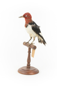
Animal specimen - Red Headed Woodpecker, Trustees of the Australian Museum, 1860-1880
Red Headed Woodpeckers can be found in Southern Canada and a large portion of the United States of America, generally migrating to the south if they originated in the northern regions. Their habitat is open forests or savannahs. They are classed as omnivores, finding food from pecking at wood or in flight. The Red Headed Woodpecker is threatened in Canada and some areas of the United States due to deforestation, lack of deadwood for nesting, competition with other birds, and a lack of food. They are an important part of the ecosystem, controlling insect populations and pollinating flora. Red Headed Woodpeckers typically have a beautiful, vibrant red neck and head, a stark white chest, black back, and black wings with white secondary remiges. They have a large chisel-like beak, suitable for foraging for their food. Their heads are rounded and they have short tails. This specimen is part of a collection of almost 200 animal specimens that were originally acquired as skins from various institutions across Australia, including the Australian Museum in Sydney and the National Museum of Victoria (known as Museums Victoria since 1983), as well as individuals such as amateur anthropologist Reynell Eveleigh Johns between 1860-1880. These skins were then mounted by members of the Burke Museum Committee and put-on display in the formal space of the Museum’s original exhibition hall where they continue to be on display. This display of taxidermy mounts initially served to instruct visitors to the Burke Museum of the natural world around them, today it serves as an insight into the collecting habits of the 19th century.This specimen is part of a significant and rare taxidermy mount collection in the Burke Museum. This collection is scientifically and culturally important for reminding us of how science continues to shape our understanding of the modern world. They demonstrate a capacity to hold evidence of how Australia’s fauna history existed in the past and are potentially important for future environmental research. This collection continues to be on display in the Museum and has become a key part to interpreting the collecting habits of the 19th century.This Red Headed Woodpecker is a small to medium-sized bird found in North America. This specimen is tricoloured: it has a red head and neck, a white chest, a black back, and black wings with white secondary remiges. It has a large chisel-like beak. This specimen has pest or humidity damage on the neck and head area. This specimen is standing on a wooden mount with a swing tag attached to it's leg.Swing-tag: 151a. Unnamed / Catalogue page, 60 /taxidermy mount, taxidermy, animalia, burke museum, beechworth, australian museum, skin, reynell eveleigh johns, bird, red headed woodpecker -
 Warrnambool and District Historical Society Inc.
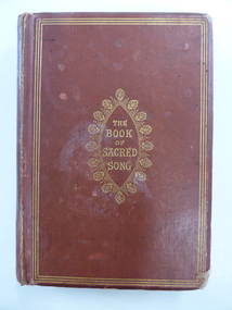
Book, The book of sacred song, 1864
This book has been given to John Ardlie by Lewis Gilles in 1866. John Martin Ardlie came to Warrnambool in 1852 as the Clerk of Courts and remained in this position until 1868. He died in 1872. He was a leading figure in community affairs for twenty years and Ardlie Street in Warrnambool is named after him. His family home was Wyton, site of the old convent at Emmanuel College today. Lewis Gilles, important in the early history of Tasmania as a bank owner and breeder of cattle, came to Warrnambool in 1854 as the first resident Police Magistrate. He remained until 1866 when he went to England (the occasion of his presentation of this book to John Ardlie). He died in 1884 in South Australia. Gilles Street in Warrnambool is named after him.This book is of high significance because of its connection to two very important early residents of Warrnambool – John Ardlie and Lewis Gilles. This is a hard cover book of 336 pages. The cover is brown with gold ornamentation and lettering on the front cover and spine. The pages are gilt-edged. The first letter of each hymn is ornamented and there is an illustration covered with tissue paper on the first page. One page shows silverfish damage and the cover is partly detached from the binding. The cover is frayed in places and a little stained. The inscription is handwritten in black ink. ‘Presented to J. M. Ardlie by his friend and comrade L.W. Gilles 1864 Worthing Sussex on departing from Warrnambool 4 May 1866’. john ardlie, lewis gilles, history of warrambool -
 Warrnambool and District Historical Society Inc.
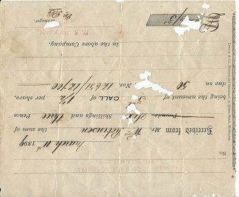
Document, Receipt March 11 1899, 1898
Grassmere is a small hamlet about 12 kilometres from Warrnambool. It is a farming area. The Grassmere Gold Mining Company, presumably established by local people in Grassmere, was created in 1898 for the purpose of acquiring from Messrs James and Mewha a lease of a Cassilis gold mine (23 acres). £5000 was to be raised in shares of five shillings and one shilling each. The Manager of the Company was Horatio Dickson of Melbourne and the brokers were McMeekin and Co. of Melbourne and Warrnambool and Dickson and Osborne of Melbourne. This reef mine was one of several in Cassilis, Gippsland, 12 kilometres north west of Swifts Creek. The gold-bearing quartz reefs were discovered in 1885 and worked to 1914. It is not known whether the Grassmere Cassilis mine was a financial success but the mining operations were impeded by the hardness of the stone in the area. William Robinson was a farmer in the Grasmere district. This receipt is of considerable interest as one of only three items the Warrnambool and District Historical Society has that is connected to the Grassmere Gold Mining Company. The gold mine establishment was one of the minor events in the district in the 1890s. This is a buff-coloured 1899 receipt for William Robinson who has paid six shillings and threepence for part payment of his shares in the Grassmere Gold Mining Company. The receipt has black printing and black-ink handwriting. There is one stamp of the Manager ‘H.S. Dickson’ and another of ‘Grassmere Gold Mining Company No Liability’. The receipt has several holes caused by silver fish damage. ‘March 11th 1899, Received from Mr Wm. Robinson the sum of six shillings and threepence being the amount of 3rd call of 1½ per share due on 50 shares nos. 12651/12700 in the above Company, H.S.Dickson, Manager’ grassmere, grassmere gold mining company, william robinson -
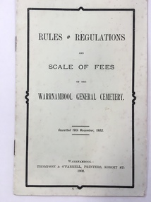 Warrnambool and District Historical Society Inc.
Booklet, Thompson & O'Farrell, Rules & Regulations scale of fees Cemetary, 1902 (original edition)
This booklet gives the Rules and Regulations and the Scale of Fees for the Warrnambool General Cemetery as from 1902. The booklet rescinded the Rules and Regulations of 1855 and amongst the 1902 Rules it is noted that no catacombs or wooden structures were allowed by the Trustees. It was also noted that no child under ten was permitted into the cemetery grounds unless under adult supervision. The charge for an adult burial was £1 and ten shillings for a child under ten. The Warrnambool Cemetery is in Otway Road, Warrnambool and was first gazetted in 1853 with Mr Whittet as the first Sexton. This booklet is of considerable interest because it gives the Rules and Regulations and the Scale of Charges of the Warrnambool General Cemetery as laid down in 1902. The Trustees at the time were William Ardlie, a prominent Warrnambool lawyer, Samuel Nettleton, a well-known Warrnambool shopkeeper and J.H.Allan, a member of a pioneering family in the Warrnambool district. This is a small booklet containing the Rules and Regulations of the Warrnambool General Cemetery. It contains four double-sided pages with printed material on all of the pages. The cover is pale yellow and the printing on the front cover has a black edging. There is some silverfish damage on the page edges. The pages were stapled together but the staples have been removed (the use of staples suggests that this booklet is perhaps a reprint at a later date)Front Cover: ‘Rules and Regulations and Scale of Fees of the Warrnambool General Cemetery, Gazetted 19th November 1902, Warrnambool, Thompson and O’Farrell, Printers, Koroit St. 1902’.warrnambool general cemetery -
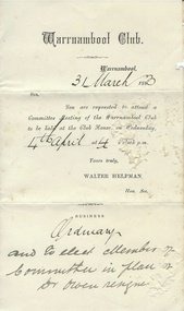 Warrnambool and District Historical Society Inc.
Document, Warrnambool Club committee meeting, 1870s, 1880s
These circular letters have been sent by the Secretary of the Warrnambool Club to committee members of the club in the 1870s and 80s. The Warrnambool Club, a club for men of some standing in the community, was established in the early 1870s and initially had rooms in the Warrnambool Club Hotel which was opened by John Amon Smith in January 1874. This hotel was in Kepler Street between Timor and Koroit Streets. By 1876 membership of the Warrnambool Club had grown to over 70 and the Warrnambool Club Hotel rooms were deemed to be too small. So the Warrnambool Club erected a new building in 1877 in Kepler Street. Today the Warrnambool Club operates today from the same building. These items are of historical significance because they are original 19th century documents associated with the Warrnambool Club, an important institution in Warrnambool for over 140 years. These are five sheets of paper folded to make four pages for each sheet. They date from the 1870s and 80s and are circular letters sent to committee members of the Warrnambool Club regarding forthcoming meetings. The letters are printed with handwritten material in the spaces of the first four items for the dates, signature of the Secretary and the business of the meeting. The handwriting is in black ink. Item One has been badly damaged by silverfish.warrnambool club, walter helpman, history of warrnambool -
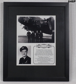 Bendigo Military Museum
Photograph - PHOTOGRAPHS FRAMED RAAF, SAFE HOME, C.1944 - 45
John Joseph MASON No 418670 Wireless Air Gunner (WAG) enlisted in the RAAF on 29.5.1942 age 19 years. After 5 Training postings he embarked for Canada on 15.1.1943 arriving 31.1.1943. He then did Training in Edmonton, Calgary and Mossank before embarking to England 21.10.1943 arriving 30.6.1943. After more Training at several postings he was finally posted to No 158 SQD RAF flying Halifax Bombers and commenced operational flying on 5.11.1944. He rose through the ranks to Flt Sgt on 31.12.1944 and then granted a Commission as F/O on 12.3.1945. He transferred to 466 SQD RAAF on 26.5.1945. His records are a bit sketchy but it appears he flew 11 Operational Sorties. His Commission was terminated on 19.3.1946. His brother Hugh who was also in the RAAF and home at the time told the story that when the aircraft was hit his mother new something had happened to Jack.Photograph, framed. Safe home. The frame is black smooth wooden type. A montage of 2 black and white photos and a description. Large photo shows 4 crew members standing in front of a damaged Halifax bomber. Small photo is of air crewman flying officer JACK MASON (WAG) of Bendigo. The story covers the raid that aircraft was on, how the side exploded out, and the crew members names.Rear has "From HUGH MASON and the MASON family"photography - photographs, raaf ww2, 158 sqd -
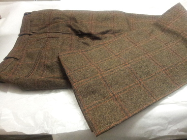 Bendigo Historical Society Inc.
Clothing - TROUSERS - PART OF MAN'S THREE PIECE BROWN TWEED SUIT, 1940's - 50's
Clothing. Trousers, part of Man's Three Piece Brown Tweed Suit, Pure wool - brown with fine black and red stripe forming a plaid type pattern. Side pockets, rear bound pocket, coin pocket at front waistband. Some insect damage on front and left rear. Plaid front (No pleat ). 7 belt loops on waistband. Hook fastening at centre front.costume, male suit, tweed suit trousers