Showing 10913 items
matching land
-
 Whitehorse Historical Society Inc.
Document, William James Moffatt, 1866-1945
Information about William James Moffatt, an orchardist in Mahoneys Road, Burwood East.Information about William James Moffatt, an orchardist in Mahoneys Road, Burwood East, after purchasing land there in 1907 and until his death in 1945.Information about William James Moffatt, an orchardist in Mahoneys Road, Burwood East. moffatt, william james, orchardist, orchards, mahoneys road, burwood east, moffatt, ian -
 Phillip Island and District Historical Society Inc.
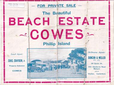
Brochure, Beach Estate Cowes, c 1940's
Advertising Land for Sale in Cowes, Phillip IslandFour page colour Brochure advertising land in Devon Avenue and Cornwall Avenue, Cowes, For Sale. Illustrations of Cowes Pier, The Beach at Cowes and motoring on the Island.Four pages of Real Estate lingo!! Agents - Chas Grayden Jnr, Cowes and Duncan & Weller, Malvernreal estate, cowes phillip island, charles grayden jnr., cowes, duncan & weller, malvern & canterbury -
Whitehorse Historical Society Inc.
Map, Subdivision of Allotment 122a, 1972
Subdivision of land along Livermore Close and Moore Road, Vermont South.Subdivision of land along Livermore Close and Moore Road, Vermont South. Original survey Rob Poole 1899. Stamp indicates 'Land on this plan is in proclaimed survey No 21. Survey Coordination Act 1940. As from 9 Aug 1972. Two maps in different scales.Subdivision of land along Livermore Close and Moore Road, Vermont South. land subdivision, livermore close, vermont south, moore road, vermont south, dandenong creek -
Whitehorse Historical Society Inc.
Article, Winlaton faces closure, 1993
Winlaton, now known as Nunawading Youth Residential Centre will close and relocate.Winlaton, now known as Nunawading Youth Residential Centre will close and relocate to the Baltara Reception Centre in Parkville and the remaining 8.4 ha land will be sold.Winlaton, now known as Nunawading Youth Residential Centre will close and relocate.youth services, winlaton, nunawading youth residential centre -
4th/19th Prince of Wales's Light Horse Regiment Unit History Room
Pamphlet, Royal Australian Armoured Corps Advanced Signal Training 1981, 1981
Used by the RegimentSoft covered loose leaf book, the RAAC extract from the Manual of Land Warfare Part Two, Signal Training Volume 2 detailing communications techniques and radio telephone proceduresRoyal Australian Armoured Corps Advanced Signal Training. RAAC extract from the Manual of Land Warfare Part Two, Signal Training Volume 2 Communications Techniques Pam No 3 Telephone Procedures (All Corps) 1980signals training, royal australian armoured corps, handbook -
 City of Moorabbin Historical Society (Operating the Box Cottage Museum)
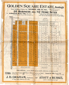
Flyer - Golden Square Estate, Bentleigh, 1923
Land sales in the Municipality of Moorabbin increased when the train line from the City to Frankston was electrified.Example of the progress of the Municipality of MoorabbinThe train line from the city to Frankston was electrified which intensified the sale in the municipality of Moorabbin, particularly land which was in the vicinity of the railway stations.Golden Square Estate, Bentleigh - J. D. Graham, Stott & Burke - 25 business sites and 112 home sitescentre road, brewers road, jasper road, robert street, mitchell street, daley street, bendigo avenue, auction, real estate, moorabbin, bentleigh -
 Ballarat Heritage Services
Photograph - Colour, Clare Gervasoni, Borsa Crescent, Hepburn Springs, from Bellinzona, 2004, 28/06/2004
The block of land depicted has been leveled with a huge rock barrier around the corner perimeter.Block of land on the corner of Borsa Crescent and Seventh Street taken not long after Bellinzona and Wanda Inn had been burnt down.bellinzona, actea, hepburn springs, church avenue, seventh street, borsa crescent, wanda inn, fire -
 National Vietnam Veterans Museum (NVVM)
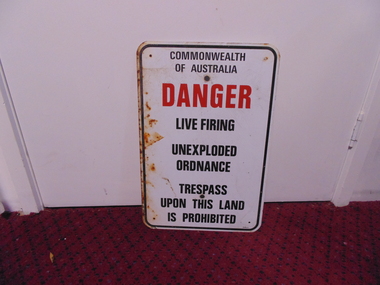
Sign - Sign, Danger
A white rectangular metal sign with rounded corners and a black line border. It has holes drilled in four corners. plus two larger central holes for fixing it to wall or pole and is rusted on the left side. Centre justified warning message reads: Commonwealth Of Australia (in black)/ DANGER (in red) /Live Firing/ Unexploded/Ordnance/ Trespass/ Upon This Land/ Is Prohibited. Centre justified message reads: Commonwealth Of Australia (in black)/ DANGER (in red) /Live Firing/ Unexploded/Ordnance/ Trespass/ Upon This Land/ Is Prohibited. sign, commonwealth of australia, danger, warning -
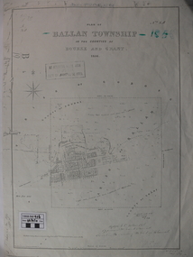 Ballan Shire Historical Society
Map - Map. Ballan Township, Plan of Ballan Township in the Counties of Bourke and Grant
The map is an early one of the township of Ballan showing street names and land owners.The map is significant in that it lists the owners of the house blocks within the township.A map showing the township and surrounding area of Ballan in 1856. Town streets are named as are the owners of the subdivided blocks of land. The map is a lithocopy and there is a scale in chains."D D Fraser" is written across the top of the map and "1856" is written in the near top right corner. There are other additions to the map but they are very difficult to decipher accurately or completely.ballan, ballan township map, ballan1856 -
4th/19th Prince of Wales's Light Horse Regiment Unit History Room
Manual - Folder, loose leaf, Royal Australian Armoured Corps Signal Training 1985, 1985
Used by the RegimentSoft covered loose leaf book. The RAAC extract from Manual of Land Warfare Part 2 Signal Training Volume 2, detailing procedure to be used for radiotelephone communications throughout the Army. Includes Amendment list No 1.RAAC Signal Training 1985. RAAC Extract from Manual of Land Warfare Part 2. Signal Training Volume 2, Pamphlet No 3. Radio Telephone Procedure (All Corps) 1983hand book, radio training, royal australian armoured corps -
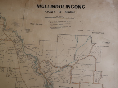 Kiewa Valley Historical Society
Parish Map - Mullindolingong, County of Bogong
The Department of Lands regularly updated the occupiers with leases or licences of the land.The names of the early settlers of the Kiewa Valley occupying land by lease or licence are shown. Many of these familie's descendants still live in the Kiewa Valley.Government (Lands Department?) cloth map showing the leases or licenses of occupiers of the land in the valley. The Kiewa River is shown in blue and roads in yellow. There is no date on the map.parish of mullindolingong map, settlers of the kiewa valley -
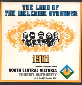 Bendigo Historical Society Inc.
Ephemera - Edith Perry Collection: 45 record and sleeve "The Land of the Welcome Stranger" by (group) 1901, specially composed for the North Central Victoria Tourist Authority, 1966
The Land of the Welcome Stranger music CD 45 record and sleeve "The Land of the Welcome Stranger" by a fiver piece male band "1901", specially composed for the North Central Victoria Tourist Authority date of production not stated. -
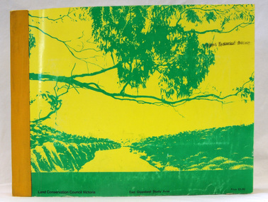 Orbost & District Historical Society
book, Report on the East Gippsland Study Area, June 1974
In 1961 Bruce Evans was elected to the Victorian Legislative Assembly as the member for Gippsland East. He was the party's deputy leader from 1964 to 1970 and its whip from 1970 until his retirement in 1992. "The Land Conservation Council was established by the Land Conservation Act 1970. As one of its three functions, it makes recommendations to the Minister for Planning and Environment with respect to the use of public land, in order to provide for the balanced use of land in Victoria. This report contains the Council’s final recommendations concerning the use of public land in the East Gippsland study area, the boundaries of which correspond to those of the Shire of Orbost. The recommendations in the text are grouped under major headings, such as Parks, State Forest, and so on. " The Council met on seven occasions during the year, and also made visits of inspection to each study area. The Chairman visited Shire Councils in study areas to explain the role and the functions of the Land Conservation Council and to invite submissions on the use of public land in these areas. This is the fourth annual report by the council. This is a useful research tool.A large book 236 pp book with a yellow / gold cover with a green bush scene . The binding is orange. It contains folded maps and information on public land use in East Gippsland.inside - "With Compliments - Bruce Evans, M.P."east-gippsland-study-area conservation public-land-use -
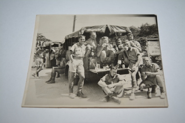 Wangaratta RSL Sub Branch
Photograph
Image mostly likely taken in the Middle East depicting group of eight soldiers eating and drinking at rear of stationary land rover. Soldiers' surnames are listed on rear with exception of one, entitled "self" and possibly Albert Robert WILLS VX5275, who sent image to parent/s. Soldiers possibly served with the 2/5 Infantry Battation which was raised in Victoria in 1939 and were deployed to North Africa and New Guinea.Black and white photograph of soldiers eating and drink at rear of stationary land rover.Handwritten on back - Taken whilst on the tour. Here we were 5-6000ft above sea level. Sgts Johnston, Ridge, ? Ptes ?Evans, Miller, Self, Murnane, ?Clem, Humphries Love Son xxxww2, 2/5 aust. infantry battalion, north africa, albert robert wills, sgt johnston, sgt ridge, private evans, private miller, private murnane, private clem, private humphries -
Whitehorse Historical Society Inc.
Article, Whitehorse vision for Healesville, 2014
City of Whitehorse Vision for Healesville Freeway Reservation.City of Whitehorse Vision for Healesville Freeway Reservation to include open space, sustained natural environment and some residential development covering 19% of the land.City of Whitehorse Vision for Healesville Freeway Reservation.healesville freeway reservation, city of whitehorse -
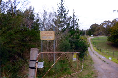 Whitehorse Historical Society Inc.
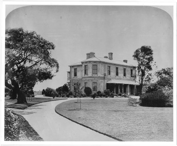
Photograph, Nethercote property, 2012
The land photographed is widely known as Nethercotes. In 1920 Arthur Nethercote, import agent, bought the land which was situated in Boronia Road near Dandenong Creek. Originally a flower farm, the Nethercotes became poultry farmers. The property contained a five-roomed weatherboard house which they called Weston Favell. Dated before 1883 (from newspapers found in the ceiling) it is the more dilapidated house photographed. The other house called Greenways was built for a son. Gerald Letts bought the property and when he died the Board of Works purchased the land, intending to use it as part of the proposed Healesville Freeway, meanwhile the property was leased to the Box Hill Institute's equine department. In 2013 the Board of Works announced that the freeway would not go ahead.Coloured photographs of the two houses and land at the Nethercote property, Vermont. Now owned by the board of Works and leased to the Box Hill Institute.nethercote property, vermont, board of works, proposed healesville freeway, box hill institute -
 Bacchus Marsh & District Historical Society
Map, Subdivision of the Manor House Property Bacchus Marsh c.1908
This land sales plan shows allotments of land offered for sale in the inner township area of Bacchus Marsh in 1908. The land put up for sale was from the estate of the late Mr and Mrs J.E. Crook. That being James Elijah Crook and his wife Harriet, (nee Athorn). The Crooks had been resident in Bacchus Marsh since the 1840s and were prominent members of the community. They were prominent in the business, social and civic affairs of the town and district. In the 1850s the Crooks acquired the Manor House and nearby land once owned by the Bacchus family. James Crook died in 1889. When Harriet Crook died in February 1908 their estate was offered for sale. This included the large stone home known as the Manor House and various parcels of land including around 50 allotments of land near the Manor House, bounded by Young, Lerderderg, Crook and Main Streets. Most of these allotments of land were sold in October 1908. The Manor House itself was passed in at the sale and continued to be owned by the Crook family for several decades after 1908.A single page map on a single page of a bound volume of maps. The map shows portions of land for sale from the subdivision of the Manor House property in Bacchus Marsh in 1908. The names of most of the buyers of the portions of land have been hand-written into the various allotments they purchased. The maps are pasted into a bound volume containing 76 maps or plans in total. High resolution digital image stored on BMDHS computer network. bacchus marsh victoria maps, land sales bacchus marsh, manor house bacchus marsh, crook family bacchus marsh -
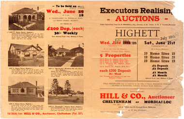 City of Moorabbin Historical Society (Operating the Box Cottage Museum)
Flyer - Executors Realising Auction for land in Highett, 1941
The Great Depression of Australia halted the sale of land in most circumstances - this sale was just after the end of the depression years of 1930 to 1939.Example of the progress of the Municipality of MoorabbinAdvertising flyer for auction of real estate sales - plan of building blocks for saleSale of land in Highett - Hill & Co (A. W. Hill, Auctioneer) - brochure has pictures of the houses on the properties being offered for saleviola crescent, wickham road, henry street, real estate, highett, moorabbin, auctions, benjamin lowden -
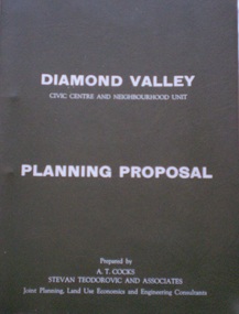 Greensborough Historical Society
Document - Planning Document, Diamond Valley Civic Centre and Neighbourhood Unit: Planning Proposal, 1960s
This document proposes the change of land use from farming and quarrying to residential. This also includes the proposal for a Civic Centre in the (then) Shire of Diamond Valley. The plans listed in the 'Schedule of Plans' on last page are missing.Includes proposal for the Aqueduct to be converted to an underground system. Includes statistics relating to population increase. Dark brown plastic folder. 23 foolscap-size pages. Maps, Application for Permits to subdivide land in the Greensborough area.partington family, mitchell family, whittingham family, albion reid, diamond valley civic centre, shire of diamond valley -
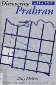 Surrey Hills Historical Society Collection
Book, Discovery Prahran - Area Two, 1999
This booklet provides a general picture of Prahran as it developed from the first Crown land sales of 1840 to its amalgamation with the City of Malvern in 1994This booklet provides a general picture of Prahran as it developed from the first Crown land sales of 1840 to its amalgamation with the City of Malvern in 1994prahran (vic) - history, toorak (vic) - history, armadale (vic) - history, (ms) betty malone -
Whitehorse Historical Society Inc.
Document, Extracts from Nunawading Council minutes, 1949
Extracts from Nunawading Council minutesExtracts from Nunawading Council minutes: (1) June 1949 Ambulance station requested (2) 24 June War service homes will be erected on land acquired by the Commonwealth Government, bordered by Duckman Street, Amery Avenue, Hirst Street & Middleborough Road (3) 1 July Proposal to build Infant Welfare Centre at Nunawading on land at rear of Municipal Chambers.Extracts from Nunawading Council minutescity of nunawading, war service homes, duckham street, blackburn, amery avenue, blackburn, hirst street, blackburn, middleborough road, blackburn, infant welfare centres, mitcham scout group, mitcham guide group, charlotte street, blackburn south, ayr street, blackburn south -
Whitehorse Historical Society Inc.
Document, James Cowley Morgan Fisher, n.d
Document re James Cowley Morgan Fisher, Thomas Bowen and Charles Carter .Document re James Cowley Morgan Fisher, Thomas Bowen and Charles Carter and land at Dorset & Canterbury Road and LL Road (Boronia Road) and Canterbury Road.Document re James Cowley Morgan Fisher, Thomas Bowen and Charles Carter .fisher, james cowley morgan, bowen, thomas, carter, charles, l l vale road vermont, boronia road, vermont, vermont, dorset road, bayswater, canterbury road, vermont, bayswater -
Whitehorse Historical Society Inc.
Article, Unfolding a Family Vision, 2001
Photocopy of newspaper article with photos of the Matheson FamilyPhotocopy of newspaper article with photos of the Matheson Family who donated land originally for the Strathdon Community Aged Care Complex, Forest Hill, by Sandro Olivio.Photocopy of newspaper article with photos of the Matheson Family matheson family, strathdon community, aged people, miller, marny, matheson, mac, matheson, john, matheson, mary -
 St Kilda Historical Society
Photograph, Ascog, Southey St, Elwood, c.1872
Ascog Southie St. Residence in 1872 of Gavin Gibson, Merchant. Demolished. Land subdivided and now inclues Avoca Avenue and courtblack and white photograph, unmounted, copy, good conditionOn back: Ascog Southie St. Residence in 1872 of Gavin Gibson Merchant. Demolished and land subdivided and now inclues Avoca Avenue and court -
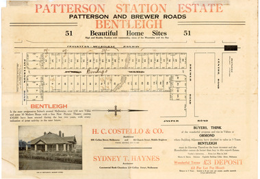 City of Moorabbin Historical Society (Operating the Box Cottage Museum)
Flyer - Patterson Station Estate, 1927
The train line from the city to Frankston was electrified in 1922 which intensified the sale in the municipality of Moorabbin, particularly land which was in the vicinity of the railway stations.Example of the progress of the Municipality of MoorabbinThe train line from the city to Frankston was electrified in 1922 which intensified the sale in the municipality of Moorabbin, particularly land which was in the vicinity of the railway stations.Patterson Station Estate, Bentleigh - 51 home sites - Auction Saturday 26 May 1927 - H. C. Costello & Co.patterson road, purton avenue (now bendigo street), brewer road, real estate, bentleigh, patterson, auction -
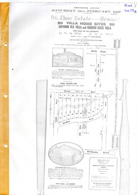 City of Moorabbin Historical Society (Operating the Box Cottage Museum)
Flyer - St Elmo Estate, McKinnon / Ormond, 1927
The train line from the city to Frankston was electrified in 1922 which intensified the sale in the municipality of Moorabbin, particularly land which was in the vicinity of the railway stations.Example of the progress of the Municipality of MoorabbinThe train line from the city to Frankston was electrified in 1922 which intensified the sale in the municipality of Moorabbin, particularly land which was in the vicinity of the railway stations.St Elmo Estate, McKinnon Auction 19 February 1927 20 Villa Home Sites Superior W.B. Villa "St Elmo" and Modern Brick Villamurray road, hawthorn grove, ormond, mckinnon, real estate, auction -
 Bendigo Historical Society Inc.
Administrative record - Land Sales Register
Large cloth bound ledger, hard board cover, front and back. Over a hundred pages not all numbered. Handwritten. Dates from 1906 - 1922. ledger filled with names, addresses, financial details, and glued in posters of land sales associated with clients. Castlemaine is listed as the area for the ledger and also St Anaud, Maryborough, Avoca, Inglewood, Dunolly, Daylesford, Maldon, Heathcote, Woodend. Scratched on the front cover is a faded reading of 'Castlemaine.' Written onto the spine is written in blue texta, 'Land Sales, C'Maine,' and also '8.6.1906 to 23.2.1922.' land sales, register, castlemaine -
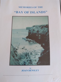 Peterborough History Group
Book, Memories of the Bay of Islands + Crofts Bay Huts
Early use of Crown Land for holiday makers prior to the Great Ocean Road extension, when leaseholders were forced to relinquish their land and houses. Includes a list of the names of occupants at that time. Also includes letters from the Crown Lands Dept about the efforts to retain the Crofts Bay Huts.Significant because it is an eyewitness description of the huts which were demolished in the mid 1970's. Also describes holiday activities and mentions other families in the area.Folder containing the photocopy of the book by Joan Densley and the separate story of the Crofts Bay huts.including copies of Crown Land documents and letters. Includes copy of photographs of the huts and beach.peterborough, crofts bay, bay of islands, joan densley, great ocean road, crofts bay huts, bay of islands huts -
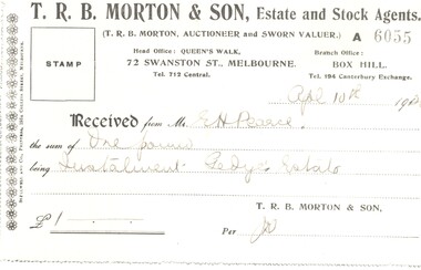 Whitehorse Historical Society Inc.
Legal record - Ephemera, E. H. Pearce, 1920
A receipt for one pound.A receipt for one pound as a deposit on land at the Gedye's Estate issued by T. R. B. Morton & Son to E. H. Pearce on 4 Apr 1920.A receipt for one pound. pearce, edward h., gedye's estate, morton, thomas richards burrowes & son -
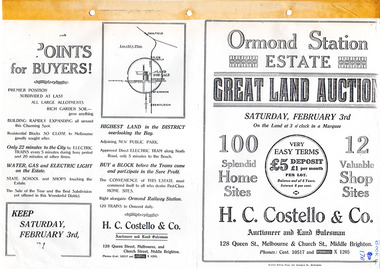 City of Moorabbin Historical Society (Operating the Box Cottage Museum)
Flyer - Ormond Station Estate, Ormond, 1923
At the end of World War One, there was a renewed interest in residential land and a number of estates opened up in the Municipality of Moorabbin.Example of the progress of the Municipality of MoorabbinAdvertising flyer for auction of real estate sales - plan of building blocks for saleOrmond Station Estate, Ormond - Great Land Auction - 100 Home sites 12 shop sites - Auction Saturday 3rd February 1923malane st, foch st, coane st, beatty crescent, ormond, real estate, auction