Showing 2057 items matching "crossings"
-
 Ballarat Tramway Museum
Photograph - Black & White Photograph/s, Wal Jack, 12/04/1950 12:00:00 AM
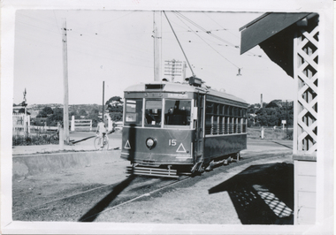
Black and White print contained within the Wal Jack Bendigo and Geelong Album, see Reg Item 5003 for more details. Photo of Bendigo Birney No.15 at North Bendigo, Photo Wal Jack, with the destination of Golden Square - 12-4-1959. Has the level crossing and rail line in the background and part of the tram stop shelter. i1 - scan of print in the album i2 - rear of image i3 - scan of negative at 3200dpi added 6/6/2020. On the rear in black ink "SEC Bendigo, No. 15 at Nth Bendigo 12-4-1959. Has the Wal Jack copyright stamp in the top right corner with the number "T219" written in.trams, tramways, bendigo, north bendigo, level crossings, birney, tram 15 -
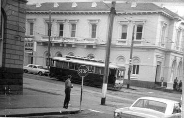
 Ballarat Tramway Museum
Negative, Wal Jack, early 1960's
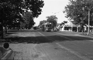
Yields information about Ballarat tram operations in Drummond St South during the early 1960's at the Urquhart St Loop.Negative and Digital images of the Wal Jack Ballarat Negative file of 41 and 21 northbound in Drummond St South after crossing No. 39 at the Urquhart St loop. No. 41 (Lydiard St Nth) and No. 21 (City). Both cars have adverts for dancing at Civic Hall and No. 21, Twin Lakes. In the background is a store advertising The Age, The Sun and The Herald newspapers. Photo early 1960's. See Reg Item 376 for a photo taken at the same time - note the car mirror.trams, tramways, drummond st south, urquhart st, tram 41 tram 21 tram 39 -
 Falls Creek Historical Society
Journal - Ski-Horizon Vol 6 No 6
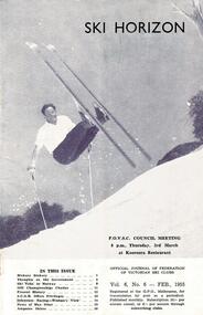
Ski-Horizon is the official journal of the Federation of Victorian Ski Clubs which began publication in 1949. The were 26 original member clubs which included Albury Ski Club, Bogong Ski Club, Myrtleford Ski Club, Tallangatta and District Ski Club and Wangaratta Ski Club. Two pioneers of Falls Creek, Tom Mitchell, M.L.A., and Martin Romuld were Vice-Presidents of the Federation.This Journal is significant because it documents the early development of skiing in Victoria.The journal features stories and events chronicling developments in Victoria and internationally. Items related to the Falls Creek Area in this issue include:- Cover - Rudi Wurth, winner of the National Slalom and Downhill titles at Kosciusko, 1954. Page 2 - SEC has assisted Falls Creek Village again by installing a culvert for the Creek crossing in front of the Bogong Lodge. Page 3 - SEC is considering the possibility of giving skiers more freedom of movement on the road between Mt. Beauty and Howman's Dam.bogong ski club, falls creek road access, sec falls creek -
 Melbourne Tram Museum
Pamphlet, The Met, "Low Floor light rail for the Upfield line - it is a better way to go", c1989
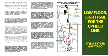
Pamphlet - four fold DL size full colour titled "Low Floor light rail for the Upfield line - it is a better way to go", explaining or providing advice on the proposal for the conversion of the Upfield line to Light rail and timing. Has a map of the proposal - has a translation in 11 languages. Includes a map showing the proposals, project details, why, level crossings, rail services and timing and proposals for a shuttle along Sydney Road. Second copy added 17-7-2017.trams, tramways, light rail, upfield light rail, conversion, sydney rd -
 Melbourne Tram Museum
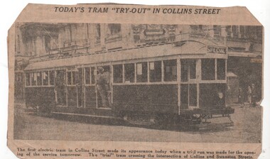
Newspaper, The Herald, Today's tram tryout in Collins St, 7/12/1929 12:00:00 AM
Newspaper Clipping - from possibly The Herald newspaper, of the test tram in Collins St Melbourne. The photo is of the trial run that day, 7/12/1929. The line formally opened on Sunday 8/12/1929 - reported in The Argus - see http://trove.nla.gov.au/newspaper/article/4055395/475869 - accessed 2/11/2016. Photo of the tram crossing Collins and Swanston Streets. Tramcar number indistinct - could be 352. See Reg Item 1808 for the first tram photos.trams, tramways, collins st, opening, conversion, trials, tram 352?, w2 class, swanston st -
 Melbourne Tram Museum
Photograph - Photograph Card, Kelly Collection, View Productions, Princes Bridge / Batman Ave tram terminus, Photo c1920
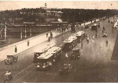
Photograph Card - folded card, blank inside of Cable Trams, motor cars, pedestrians crossing Princes Bridge over the Yarra River with the Princes Bridge / Batman Ave tram terminus with a shelter in the background. Shows five cable tram sets. Has railway signals and Government House in the view. Produced by View Productions GPO Box 1858 Sydney, from the Kelly Collection, titled "On the Princes Bridge, circa 1920, Melbourne, Victoria, Australia". Has the Publishers logo on the rear.trams, tramways, princes bridge, batman ave, swanston st, cable trams, shelters -
 Melbourne Tram Museum
Photograph - Set of 6 Black & White Photograph/s, 1959 to 1960
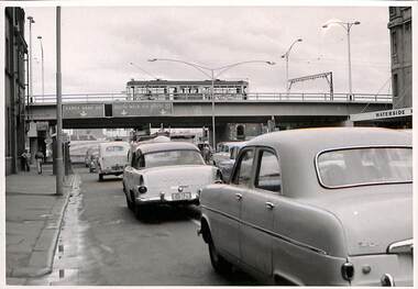
Set of 6 photographs of the Flinders St flyover over Kings St, soon after opening with tramcars and motor vehicles on the streets and bridge. Has the Waterside Hotel on the right side of the photographs. Has the pedestrian crossing traffic lights in the views. Don Storey's tramway history notes - http://www.classicaustraliantv.com/Gunzel.htm accessed 23/6/2019 notes that for 1959 - Temporary track on a new flyover in Flinders Street at King Street was brought into use; the permanent track was completed on June 26, 1960.Photos were contained within an envelope marked "Secretary Head Office MMTB (616 Lt Collins St) and "Please do not fold.trams, tramways, king st, flinders st, bridges, traffic lights -
 Melbourne Tram Museum
Photograph - Set of 4 Colour Print/s, Keith Stodden, c2010
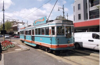
Set of four colour prints of Melbourne trams operating in Bendigo for the Bendigo Trust, c2010. Photos not dated and assumed taken by Keith Stodden. .1 - SW5 808 at Charing Cross in a light blue livery carrying a Hume and Iser Timber and Hardware adverts. VicSig has a photo of the tram in 2007. .2 - W6, 976 as Cafe tram 976 crossing Charing Cross .3 - SW5 808 at Central Deborah mine terminus. .4 - SW6 880 at the depot.Has a $15 price label on rear.trams, tramways, sw5 class, bendigo, charing cross, tram 808, tram 976, tram 880 -
 Melbourne Tram Museum
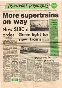
Newspaper, Ministry of Transport, "Transport Progress", Jul. 1983
Eight page newsprint Newspaper, titled "Transport Progress", issued by the Ministry of Transport, late 1982 with a collection of newspaper stories about Melbourne transport dated to early Nov 1982. Has stories about more Comeng trains, new articulated trams for Melbourne, merger of the transport bodies, restructure, Jolimont, Domain Interchange, level crossings, Restaurant tram and rail and road safety. 2nd copy added 5-6-2016 from Charles Craig Collection..trams, tramways, melbourne, mmtb, metropolitan transit authority, the met, state transport authority, sta -
 Stawell Historical Society Inc
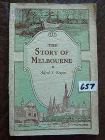
Book, Alfred S Kenyon, The Story of Melbourne by Alfred S Kenyon, 1934
This Book is most interesting - Melbourne's Beginnings. The Inscription in front of this book M.G. Phillips (nee Taylor), taught school at Concongella during World War II.Soft Card cover of a green and cream colour Three Separate Panels on front cover. Top panel contains a drawing of a ship moored at shore with trees in background. Send Panel Is a Shield with curled side inside is The Title and Authors Name in Brown print. The Lower Panel is the largest contains a drawing of a river with a bridge crossing it, also a church and domed building with a clock tower in the distance. Back Cover contains a drawing of a series of books, in the shape of question mark with a Kookaburra sitting at the top.Inside front cover hand written M.G. Phillipsstawell education -
 Ringwood and District Historical Society
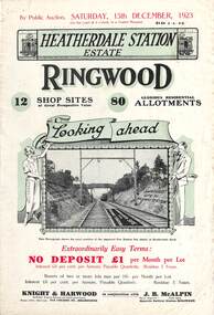
Flyer, Subdivisional Land Auction Sale Brochures, Heatherdale Station Estate, Ringwood, Vic. - 1923 and 1924
Two double sided multi-folded pages advertising public auction sales of shop sites and residential allotments on Saturday, 15th December, 1923 and Saturday, 2nd February, 1924, including summary of local facilities, services and map showing layout of the estate. Includes a photograph depicting proposed site for first Heatherdale railway station and a panoramic view of Ringwood from the railway level crossing in Heatherdale Road. 1923 and 1924 flyers are identical except for the auction dates printed at the top.Subdivision includes Heatherdale Road, Molan Street, Yallourn Parade, Newman Street, and Madden Street. Agents - Knight & Harwood, 315 Collins Street, Melbourne, Phone 10615, 10616 Central, in conjunction with J.B. McAlpin, Opposite Railway Station, Ringwood. Phone Ringwood 7. Additional cardboard-backed copy of map includes later penciled sales notations for some blocks (VC 5801 refers). -
 Eltham District Historical Society Inc
Postcard - Photograph postcard, Old Bridge, Kaylock's Crossing, Brougham Street, Eltham, c.1912
Date estimated to be circa 1912 based on the style of printing on the reverse of the card - Kodak Austral paper for real photo postcards, the paper was manufactured c.1908-1914 (See also POSTCARDS ON KODAK PAPER - IS IT POSSIBLE TO "DATE" THEM? http://tps.org.au/bb/viewtopic.php?t=115) Brougham Street was created in Josiah Holloway's 1851 subdivision of Little Eltham. It was one of several east-west streets shown on the subdivision plan as crossing the Diamond Creek. The western part was named Wellington Street on the subdivision plan but was later changed to conform with the name of the eastern part as acknowledgement of the continuity of the street. It is not known when the first bridge was constructed in Brougham Street however it was certainly mentioned at Council’s meeting of 2 June 1884 as being in a dangerous state of repair. This photo (c.1895) of an old bridge shows a very low-level simple log girder bridge crossing the creek at a right angle and so the approaches involved bends in the road alignment. This bridge was generally known as Kaylocks Bridge or Kaylock’s Crossing after the owner of the adjoining land. It was most likely built from around the mid-1850s, or a crossing of some fashion established as Richard George Kaylock, butcher of Little Eltham and his wife Emily Ann settled there in 1854. His property was in Wellington Street (now Brougham Street) and apparently extended across the Diamond Creek. The land on the western side of the creek was farmed, the house being on the eastern side. Kaylock's Bridge formed part of the original coach road to Eltham and in 1922 was described as an "old rustic bridge". Its low level and insubstantial construction made it susceptible to flood damage, necessitating frequent closures until repairs could be carried out. In September 1922, Council called for tenders for a new timber bridge to be constructed at Kaylock’s crossing. An engineering assessment carried out for the Council by Macleod Consulting at the time of the replacement suggested that the construction details indicate that it was in the 1900s, however this dating could possibly have been the result of numerous repairs undertaken over the years to flood damage. The tender was awarded to Mr Weller of Kangaroo Ground who commenced work in February 1923 on a higher-level timber trestle bridge. Work was slowed due to illness of the contractor and the accidental death of a man in March 1923 following the collapse of the bank after he had jumped into a hole that had just been blasted. The bridge was completed around July 1923 at which point the old structure was pulled up, marking what was described in the ‘Advertiser’ newspaper as the passing of an old and well-loved landmark in the district. In April 1924 the approach to Kaylocks bridge was washed away during the heavy flooding that destroyed the Main Road bridge. The western side was repaired, and an extra span was added to the eastern side using timber from the destroyed Main Road bridge. The bridge was again severely damaged four months later in August 1924 When a lack of finances delayed repairs to the Bridge Street bridge in 1931 (also referred to as Obelisk Bridge at the time), traffic had to detour via Brougham Street for some time. Local residents feared that the Bridge Street bridge might never reopen. Kaylocks Bridge was constantly subject to damage by floods. In the 1934 flood it was submerged by two feet of water. In more recent times the bridge was again severely damaged by flooding and repairs made. A new bridge and adjoining footbridge were constructed in 2009.Digital file only Postcards scanned from the collection of Michael Aitken on loan to EDHS, 2 Sep. 2022michael aitken collection, eltham, postcards, bridge, brougham street, diamond creek (creek), kaylocks bridge, wellington street -
 Eltham District Historical Society Inc
Photograph, Old Bridge, Kaylock's Crossing, Brougham Street, Eltham, c.1895
Brougham Street was created in Josiah Holloway's 1851 subdivision of Little Eltham. It was one of several east-west streets shown on the subdivision plan as crossing the Diamond Creek. The western part was named Wellington Street on the subdivision plan but was later changed to conform with the name of the eastern part as acknowledgement of the continuity of the street. It is not known when the first bridge was constructed in Brougham Street however it was certainly mentioned at Council’s meeting of 2 June 1884 as being in a dangerous state of repair. This photo (c.1895) of an old bridge shows a very low-level simple log girder bridge crossing the creek at a right angle and so the approaches involved bends in the road alignment. This bridge was generally known as Kaylocks Bridge or Kaylock’s Crossing after the owner of the adjoining land. It was most likely built from around the mid-1850s, or a crossing of some fashion established as Richard George Kaylock, butcher of Little Eltham and his wife Emily Ann settled there in 1854. His property was in Wellington Street (now Brougham Street) and apparently extended across the Diamond Creek. The land on the western side of the creek was farmed, the house being on the eastern side. Kaylock's Bridge formed part of the original coach road to Eltham and in 1922 was described as an "old rustic bridge". Its low level and insubstantial construction made it susceptible to flood damage, necessitating frequent closures until repairs could be carried out. In September 1922, Council called for tenders for a new timber bridge to be constructed at Kaylock’s crossing. An engineering assessment carried out for the Council by Macleod Consulting at the time of the replacement suggested that the construction details indicate that it was in the 1900s, however this dating could possibly have been the result of numerous repairs undertaken over the years to flood damage. The tender was awarded to Mr Weller of Kangaroo Ground who commenced work in February 1923 on a higher-level timber trestle bridge. Work was slowed due to illness of the contractor and the accidental death of a man in March 1923 following the collapse of the bank after he had jumped into a hole that had just been blasted. The bridge was completed around July 1923 at which point the old structure was pulled up, marking what was described in the ‘Advertiser’ newspaper as the passing of an old and well-loved landmark in the district. In April 1924 the approach to Kaylocks bridge was washed away during the heavy flooding that destroyed the Main Road bridge. The western side was repaired, and an extra span was added to the eastern side using timber from the destroyed Main Road bridge. The bridge was again severely damaged four months later in August 1924 When a lack of finances delayed repairs to the Bridge Street bridge in 1931 (also referred to as Obelisk Bridge at the time), traffic had to detour via Brougham Street for some time. Local residents feared that the Bridge Street bridge might never reopen. Kaylocks Bridge was constantly subject to damage by floods. In the 1934 flood it was submerged by two feet of water. In more recent times the bridge was again severely damaged by flooding and repairs made. A new bridge and adjoining footbridge were constructed in 2009. Part of a slide show presentation "Bridges & Waterways of the Shire" by Russell Yeoman to the 13 September 1989 Society meeting. The presentation included slides of historic photos from the Shire of Eltham Pioneers collections as well as several recent views.Photo of earliest known crossing of the Diamond Creek at brougham StreetPostcard photo printbrougham street, eltham, wellington street, kaylocks bridge, bridge, diamond creek (creek) -
 Kiewa Valley Historical Society
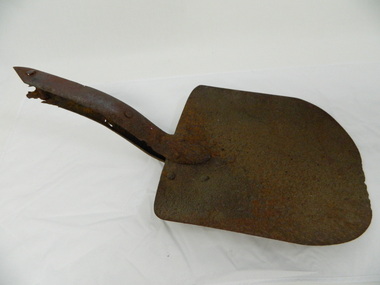
Shovel head - Fainter Falls
The Fainter Falls Walking Track was originally accessible via a fire fighting access trail, which was used by fire-fighters putting out spot fires caused by lightening strikes. The fires in the summer of 2003, highlighted the beauty of this area and provided the residents with the opportunity to consider the redevelopment of the trail. Work to establish a 700 metre grade 2 walking trail with a 50 metre grade 3 extension trail to the Falls began in 2005. It also includes 3 observation decks, a bridge over a creek crossing, car parking and interpretative signage.The shovel was found during work on the Fainter Falls track. It was left there some time ago by a previous visitor to the Falls indicating that the Falls were accessible and attracted visitors many years ago.Rusty metal shovel head curved on each side and rounded at the front. At the back of the blade it is attached on top with 3 nails to the top piece. The top metal piece overlaps the blade by 6.5 cm longitudinally x 5 cm across. On the back the metal piece overlaps the blade by 12 cm both longitudinally and across the handle end but tapers to a point. It has 6 nails attaching it. Both metal pieces are attached to the blade and curve parallel and around so that a wooden handle would fit between them. This would have 2 nails passing through both metal pieces and the handle. (The handle is missing.) shovel. fainters falls. bogong. walking track. fire track. water. -
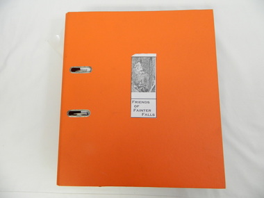 Kiewa Valley Historical Society
Folder - Fainter Falls, 2003 - 2008
The Fainter Falls Walking Track was originally accessible via a fire fighting access trail, which was used by fire fighters putting out spot fires caused by lightening strikes. The fires in the summer of 2003 highlighted the beauty of the area and provided the residents with the opportunity to consider the redevelopment of the trail. Work to establish a 700 metre grade 2 walking trail with a 50 metre grade 3 extension trail to the Falls began in 2005. It also includes 3 observation decks, a bridge over a creek crossing, car parking and interpretive signage.A Friends of Fainter Falls committee was formed to work towards the construction of a track to Fainter Falls. The contents of this folder is evidence of how a local community achieved its goals for such a project in 2003 - 2008.Large orange lever arch folder bound with 2 rings. Contains the history of the redevelopment of the Fainter Falls track 2003 - completion at the end of 2008. It is divided into: Funding Proposals. Correspondence Inwards & Outwards. Minutes and Letters of Support. Inserted separately in a large white and yellow Express Post envelope is additional information including chronology, minutes, newspaper cuttings Inserted separately is the 'Small Towns Development Fund' Application Form 2006.Cover blankfainter falls. bogong. walking trail. fire track. kiewa valley community. -
 Ballarat Tramway Museum
Photograph - Set of 7 - SEC 48 hour strike and Ballarat trams, A T Miles, 27/11/1969
Set of 7 photos of trams returning to the depot or in the depot at the time of a 48-hour strike by the SEC. Taken by A T Miles 27/11/1969. 1 - Tram 43 at depot junction returning to the depot 2 - Tram 34 at depot junction 3 - Tram 34 running into the depot with tram 21 alongside and two crew standing by the gate. 4 - Tram 17 crossing Wendouree Parade 5 - The depot gates are closed. 6 - All the trams are in - including 18 as the Santa tram, 35 and 21. 7 - All the doors are closed.Yields information about trams returning to the depot at the time of a 48 hour strike by the SEC in 1969.Photograph - black and white print with notes on rear - set of 7A T Miles stamp and location and date notes.tramways, trams, strike, sec depot, tram 43, industrial issues -
 Melbourne Tram Museum
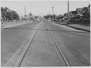
Photograph - Single track Nicholson St, East Coburg, Prior to 1967
Photograph shows single track section of tramway in Nicholson St, East Coburg looking south from Harding St. The rails are slightly sunken into bitumen covered roadway. Primary school grounds are at left, children's crossing in foreground with accompanying red and white bands painted on span poles and several motor vehicles are in the background. The models of motor vehicles and the future duplication of this track in late 1966 suggest the photograph's date of mid-1960s. This single track was the scene of many head-on collisions between south bound trams and northbound motor vehicles, especially at night.Yields information about remaining single track sections that were slow to be duplicated due to lack of funding. Black and white photograph with blue stamp and biro number on rearM&MTB Ref No. R25/1/183m&mtb, nicholson st, single track, east coburg, sunken rails -
 Melbourne Tram Museum
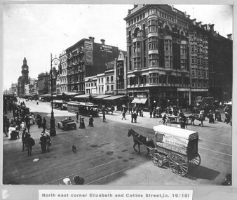
Photograph - Cable trams - Elizabeth and Collins St, 1918
Photograph shows the intersection of Elizabeth and Collins Sts Melbourne, looking North East. There are two cable trams in the view in Elizabeth St, one with a bogie trailer. There are a number of horse-drawn carts, one motor vehicle and many pedestrians crossing the streets. In the view are the GPO, a building advertising Kodak Australasia at the Block, The Windsor magazine, W E Thomas Dentist, and Dunklings. By the Dunklings store is a double decker bus with the destination of Spring St, advertising Zebra stove polish. The horse drawn covered cart is Geo Thomson Dairy Produce Merchant.Yields information about the intersection of Collins and Elizabeth St c1918Black and white print, mounted onto mauve coloured card with a printed title.tramways, cable trams, elizabeth st, collins st, buses, horse drawn vehicle -
 Melbourne Tram Museum
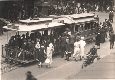
Photograph - Cable tram 357, Flinders and Elizabeth Sts, C J Frazer, early 1930s
The photo shows a cable tram set, trailer 357, at the Flinders St terminus in Elizabeth St. The tram has the return destination of North Melbourne. Note that the destination signage is both black on white letters and white on black letters. The grip or dummy is well loaded with passengers queing to board the trailer. Possibly a warm day given the ladies clothing. In the background are many pedestrians crossing the road to the station. On the corner is a Tea Rooms shop. Given the shadows, it is possibly Saturday lunch time with workers returning home after their half day of work.Yields information the Elizabeth St terminus at Flinders St and cable tram operations.Black and white photograph with photographer's stamp on the rear.Has the stamp of C J Frasers on the rear with address.tramways, cable trams, elizabeth st, flinders st, north melbourne, tram 357 -
 Mission to Seafarers Victoria
Album (item) - Photographic album, Duncan family photographic album, c.1920
The photographic album was compiled by various members of the Duncan family in connection with their social activities and charitable work with the Mission to Seafarers Victoria. Image captions refer to a number of Melbourne families: "Barker", "MacEachern", "Johnston" and "Garven." The following ships are also named: "SS Sesther Dollar", "SS Peterton" and "SS Verbania." Some photographs were even taken on board these ships (crossing the line ceremony) meaning they were likely taken by a crew member or a passenger? This would help knowing who is the photographer and maker of this album. Places named include: "Gembrook", "Portsea" and "Port Melbourne Mission."This is a photograph of social and historic significance, being part of a sub-collection of material that provides a snapshot of the type of individuals involved in the Ladies Harbour Lights Guild and the activities carried out by that organisation. Tooling on the left hand side front cover. Cover and pages tied together with mustard coloured cord as binding.barker, maceachern, johnston, garven, ss sesther dollar, ss peterton, ss oerbania, gembrook, portsea, port melbourne mission, ladies harbour lights guild, social, duncan, lillie duncan, olive duncan, duncan album -
 Ballarat Tramway Museum
Photograph - Series of 9 black and white photographs of Ballarat trams, Ellen Butland, 1971
.1 - No. 27 in Lydiard St North at Sturt St. .2 - Scene at Railway station in Lydiard St North following arrival of the ARHS tour train. .3 - Nos. 27, 42, 11 at Sebastopol terminus. .4 - No. 42 in Sturt St .5 - Nos. 27, 42, 11 at Sebastopol terminus. .6 - No. 11 in Sturt St .7 - No. 27 crossing Albert St Sebastopol. .8 - No. 42 in Lydiard St North at Sturt St. .9 - Nos. 27, 42, 11 at Lydiard St. North terminus. Note: - some of the captions under the photos have the wrong locations.Has a strong association with a Melbourne tram driver who assembled the scrap book and series of photos of Ballarat trams at the time of closure. Yields information about the tram operations.Set of nine black and white photographs contained with Reg item 5988, a Stamford Kiwi School Scrap Book - prepared by Ellen Butland of Auckland following the closure of the SEC Ballarat Tramway system."Ballarat, Australia 21-9-71" in ink along the top edge of the sheet.trams, tramways, ballarat, sturt st, sebastopol, tram 27, railway station, tram 42, tram 11 -
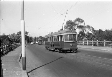 Ballarat Tramway Museum
Negative - Geelong trams 33 & 40 Barwon Bridge, Laurie Gallop, early 1956
Photo shows Geelong trams 33 & 40 in Moorabool St just south of the Barwon Bridge on the long crossing loop. Based on the running board at item 8267, most likely tram No. 33. One of a set of photos was taken between 15/2/1956 and 3/3/1956 when services operated only between Belmont and North before the final closure of the Belmont route on 25/31956 and that bogie tram 31 is not shown on the board, having gone to Ballarat on 15/2/1956 - see item 5554. See item 8213 for an article on the Geelong system by Keith Kings. Yields information about the Geelong operations toward the closure of the tram system.Black and white Negative - 120 sizetramways, geelong, moorabool st, tram 33, tram 40, barwon river -
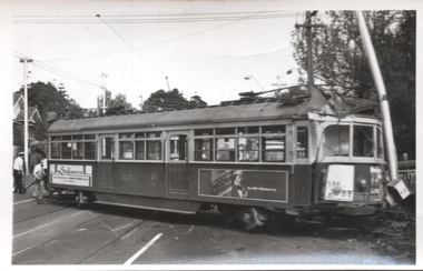 Melbourne Tram Museum
Photograph - Black & White, tram 867 derailed - Riversdale Road, 22/10/1976
The photographs show SW6 tram 867 derailed at the Riversdale Road level crossing on 22/10/1976. The tram ran out of control in Riversdale Road due to the compressor not being turned on before running out to take up a Wattle Park run. This event resulted in trams being rewired so that power to the controller could not be obtained unless the compressor had been turned on. An extract from Electric Traction magazine, Nov. 1976 has been imaged. Tram 331 would have been used in rerailing. See item 7368 for The Herald report of the date.Yields information about the 1967 derailment of tram 867,Set of four Black and White photographs - printed on plain paper and digital copy of a news item.tramways, trams, mmtb, tram 867, rivesdale road, level crossings, derailments, accidents, compressors, tram 331 -
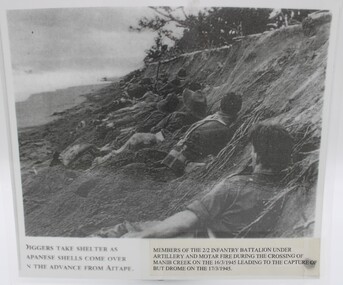 Beechworth RSL Sub-Branch
Photograph Laminated, Diggers take shelter as Japanese shells come over on the advance from AITAPE PNG
Actual photograph taken in the battlefield Actual battlefield photographer A laminated photograph depicting diggers taking cover during aerial and mortar attack in PNG 1945on bottom right corning on paper held inn place with adhesive tape: MEMBERS OF THE 2/2 INFANTRY BATTALION UNDER / ARTILLERY AND MOTAR FIRE DURING THE CROSSING OF / MANIB CREEK ON 16/3/1945 LEADING TO THE CAPTURE OF / BUT DROME ON THE 17/3/1945; on the bottom left hand side DIGGERS TAKE SHELTER AS / JAPANESE SHELLS COME OVER / ON THE ADVANCE FROM AITAPE.photograph, laminated photograph -
 Orbost & District Historical Society
pamphlets, Princes Freeway - Orbost Section, 1976
Opened by the Hon. J A Rafferty, Minister for Transport, 25 November 1976, the bridge was the first of four bridges to be built as part of the freeway bypass of Orbost. Construction cost $2.4 million. This construction was an important development along the Princes Highway corridor through East Gippsland. The original highway approached the Snowy River at a very poor alignment, and several serious accidents had occurred at the Orbost end. In times of heavy flood, the highway on both sides of the river had been cut by floodwaters and during the 1971 floods, the highest ever recorded, the river was a mile wide at the crossing. Construction of the bridges commenced in January 1975, with an expectation to open the bridge across the Snowy River as soon as possible. Less than two years later, on 25 November 1976, the bridge across the Snowy River was opened to traffic, allowing the old bridge to be demolished. The remainder of the Orbost Bypass, both the floodplain crossings and the eastern section around the township itself, was declared ‘Princes Freeway’ and opened to traffic in December 1977. (ref http://mrv.ozroads.com.au) The Country Roads Board was the government authority for the construction and maintenance of main roads in Victoria between 1913 and 1983. It was succeeded by the Road Construction authority on 1 July 1983 and later merged with the Road Traffic Authority on July 1 1989 to form the Roads Corporation. James Cameron, an Orbost farming pioneer and Member of the Legislative Assembly, fathered the Country Roads Board. The opening of this Snowy River Bridge was an important development in the accessibility to the township of Orbost.Three coloured Country Roads pamphlets for the 'Princes Freeway - Orbost Section". On the front is a coloured photograph of the new construction over the Snowy River at Orbost. Inside is a program for a ceremony for the opening of the new Snowy River Bridge. There is also a black print map of the project. -
 Sunshine and District Historical Society Incorporated
Photographs (1928), 'QUARTER MILE' BRIDGE Construction, 1928
One man lost his life during the building of this bridge. The bridge was constructed by the Victorian Railways between 1927 to 1929 to carry a new double track goods line. This enabled trains from all parts of the state except Gippsland to have direct access to the Tottenham marshalling and sorting yards. These yards were constructed in the 1920's to relieve congestion in the Melbourne Yard near Spencer Street station. The congestion was being caused by the construction of suburban passenger platforms associated with the electrification of the suburban railway network. Initially the bridge was for goods trains but during the Second World War it was also used by troop trains. When the standard gauge line was built in 1962 all trains to Albury and Sydney have used this route, thus avoiding travelling through Essendon and Pascoe Vale on the suburban tracks. The standard gauge track across the bridge took the place of one of the broad gauge tracks so broad gauge trains crossing the bridge in either direction have to now use the same track. The bridge is 1,257 feet (383.13 metres) long and 180 feet (54.86 metres) above the water level. It is just 63 feet (19.2 metres) short of a quarter mile in length between abutments. There is a similar bridge on the same railway line crossing the Moonee Ponds Creek between Gowenbrae and Glenroy, however it is smaller at 1060 feet (323.08 metres) length and 115 feet (35.05) height.The bridge is now Victorian Heritage Registered under Number: H1197, and Heritage Overlay Numbers HO5, and HO107. On the Heritage Register it is named RAIL BRIDGE (ALBION VIADUCT). According to the Heritage Report the bridge is scientifically and architecturally important because of its large size, and because of the cost effective design features such as two girders per span (one for each track), the K bracing in the towers, and the broad flange beams as columns. When it was being built it was the largest trestle bridge in Australia, and until the Sydney Harbour bridge was constructed it was the highest railway bridge.Five B&W yellowing photos showing stages of construction of the Maribyrnong River Viaduct known as the Trestle Bridge but mainly known locally as the QUARTER MILE BRIDGE. It is a railway only bridge which runs over the Maribyrnong River between Sunshine North and Keilor East. A sixth image, which is not part of this set of photos, is included to show what the completed bridge looks like. -
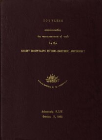 Federation University Historical Collection
book, Truth & Sportsman Ltd, Souvenir commemorating the commencement of work by the Snowy mountains hydro-electric authority, 17/10/1949
It is assumed that a member of the Ballarat School of Mines attended the commencement of work at the Snowy Mountains hydro-electric centre.Burgundy cover with gold printing. Black print, photos and diagrams on white paper (31 pages). Bound by 3 staples. The contents include the story of the Snowy. Images include W.J. McKell, J.B. (Ben) Chifley, J. McGirr, Nelson Lemmon, Hume Weir, Jindabyne valley (now flooded), Jindabyne township (now flooded), illustration of water Power, survey team at Adaminaby, Snowy Mountains Relief Plan, Horseman crossing the Eucumbene River, Mildura, Burrinjuck Dam under construction, transmission lines, W. Hudson.snowy mountains hydro-electricty scheme, snowy mountains hydro-electric authority -
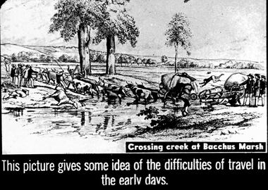 Bendigo Historical Society Inc.
Slide - DIGGERS & MINING. THE GOLD ERA, c1850s
Diggers & mining. The gold era. This picture gives some idea of the difficulties of travel in the early days. Shows 10 oxen pulling a large heavy cart through a river, a rider from the top of the cart falls off. Another cart is being pulled by a horse, one man has fallen on the ground another is headfirst of the large cart, 3 men behind the cart may be pushing. A dead horse lay by the river. Crossing a creek at Bacchus Marsh. Markings 40 994.031 GOL:5. Used as a teaching aid.hanimounteducation, tertiary, goldfields -
 Bendigo Historical Society Inc.
Document - LYDIA CHANCELLOR COLLECTION; CROSSING THE EQUATOR CERTIFICATE
A certificate with green and black ink with the heading 'Domain of Neptunus Rex.' It is a Crossing of the Equator Certificate which occurred on the 2nd Nov. 1930 in Latitude 000 '00' and Longitude 165 W on S.S. Sonoma. Initiation of Mr. L.G. Pethard, ' having been found worthy to be remembered as one of our trusty shellbacks has been gathered to our fold and duly initiated into the 'Solemn Mysteries of the Ancient Order of the Deep.' 'Davy Jones His Majesty's Scribe.' 'Neptunus Rex Order of the Raging Main.' Matson Navigation Company.document, certificate, crossing the equator, lydia chancellor, collection, mr. l.g. pethard, person, equator -
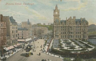 Bendigo Historical Society Inc.
Postcard - GLADYS DEAN COLLECTION: POSTCARD, 1906 - 1908
Coloured photographic postcard. Image depicts a street looking to a gothic styled building behind a formal garden. Buildings line the other side of the street which has trams and horse drawn carriages driving and people walking and crossing the street. The words Princes Street Edinburgh are printed in red along the top left hand side. Car is addressed to Miss Dean Esmond Golden Square and has a one penny stamp affixed. Handwriting is on the opposite side. The words Valentines Series are printed on the left hand side.Valentines Seriespostcard