Showing 11518 items matching "maps"
-
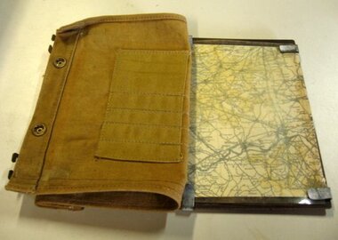 Running Rabbits Military Museum operated by the Upwey Belgrave RSL Sub Branch
Map Case
Map Holder with Map of Ypresequipment, ww1, army -
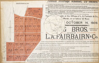 Bacchus Marsh & District Historical Society
Map, Greystones Estate Land Sale 1909
This map was produced sometime around mid 1909 to advertise portions of land from the Greystones Estate for sale by public tender. The selling agents were Young Brothers of Horsham and L.A. Fairbairn of Bacchus Marsh and Melbourne. The seller was Molesworth R. Greene who was a pioneer pastoralist in the Bacchus Marsh area and had also acquired other properties in Victoria and interstate. Molesworth Greene died in 1916 so this sale came towards the end of his life. A total of 4,176 acres was offered for sale in multiple lots. Successful tenderers could buy single or multiple lots. The results of the sale were reported in the Bacchus Marsh Express newspaper on the 16th October 1909, page 3. At the sale a total of 3, 420 acres was sold. A single page paper map showing portions of land for sale from the Greystones Estate near Bacchus Marsh. The map includes extensive details about the property, number of allotments for sale, terms and conditions of the sale and prices. The map includes an inserted reference map showing the location of the property in relation to Melbourne, Geelong, Ballarat and Castlemaine. The top of the map appears to be missing resulting in some loss of the text. The sale notice in the Bacchus Marsh Express of 10 July, 1909, page 3, column 1 appears to duplicate the text overall in the auction plan. Based on this the missing text is likely to be: "Important Subdivisional Sale 'Of Portion of One of the Best and Most Favourably known Estates IN THE RENOWNED BACCHUS MARSH DISTRICT. And situated only six miles from that prosperous township, two miles from Rowsley, and three miles from Parwan, all Railway towns, connected with the Estate by metal roads." Scale: 20 chains to 1 inch The map is pasted into a bound volume containing 76 maps or plans in total. bacchus marsh victoria maps, land sales, land sales bacchus marsh, greystones estate bacchus marsh, molesworth r. green 1827-1916, land sales rowsley -
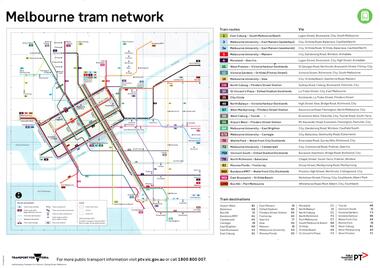
 Melbourne Tram Museum
Poster, Yarra Trams, "Melbourne Tram Network", Jan. 2014
... Maps ...Full colour poster printed on a vinyl plasticized based sheet, titled "Melbourne Tram Network" - showing a diagrammatic layout of Melbourne tram routes, Myki ticket notes and where tickets can be obtained, information numbers (PTV, phone applications) and information on Tram Tracker, twitter and other contact systems. Vertical format. Map replaced when changes made to routes 112 (split into 11 and 12 - St Kilda to Victoria Gardens) from 27/7/2014. Map dated Jan. 2014. See Reg Item 625 for a horizontal format version and 726 for an earlier version. Two copies held.trams, tramways, yarra trams, ptv, maps, tramtracker, myki -
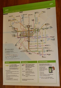
 Melbourne Tram Museum
Map, Public Transport Victoria (PTV), "Melbourne tram network", "Victorian train network", May. 2017
... Maps ...A4 printed map, full colour published May 2017 titled on one side "Melbourne tram network" and the other "Victorian train network", showing the tram and train routes, and details of each route or line. Published by Transport for Victoria and PTV. Two copies held.trams, tramways, maps, railways, tramways, victoria, tram routes -
 Bendigo Military Museum
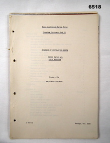
Administrative record - Royal Australian Survey Corps Planning Conference 1972 - Standard of Compilation sheets by Army Survey Regiment, Army Survey Regiment, Bendigo, 03.10.1972
This booklet was prepared for the Royal Australian Survey Corps Planning Conference 1972 by the Army Survey Regiment held at Fortuna Bendigo. It was intended to provide a trouble shooting guide for personnel engaged in the production of map compilation sheets. See also item Number 6517 "Standard of Compilation Sheets" by LtCol DR Ridge (RASvy)26 x A4 page document containing typed text diagrams and copied map extracts, photocopies and Oza film. Item is four hole puched and is held together by an ARNOS Fastenerroyal australian survey corps, rasvy, fortuna, army survey regiment, army svy regt, asr -
 Ringwood and District Historical Society
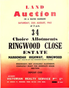
Pamphlet, Land Auction Brochure - Ringwood Close Estate, Ringwood, Victoria - 1962
Brochure advertising public auction of 34 allotments on Saturday 25th August, 1962. Brochure includes terms of sale, description of subdivision features and local facilities, with locality map. Subdivision includes Anthony Court, Nina Court and Wingrove Place, off Maroondah Highway, Ringwood.Auctioneer - Lindsay Lord, Victorian Realty Service Pty Ltd., 360 Lonsdale Street, Melbourne. Phone MU7858, After hours XF4447. Map includes handwritten pricing notations for some allotments. -
 Bendigo Military Museum
Pamphlet - An Introduction to Topographic Mapping, C 1991
This pamphlet was published by the Army Survey Regiment as an overview of the Royal Australian Survey Corps (RASvy), its role and unit structure circa 1991, prior to RASvy’s disbandment in 1996. The pamphlet comprehensively detailed the eight steps of topographic map production: Establish Survey Control, Aerial Photography, Aerotriangulation, Stereoplotting, Field Verification, Cartography, Printing and Storage/Map Distribution. Leading technologies used by RA Svy in 1991 included GPS control surveys, 5 colour printing on the Speedmaster offset press and bulk map packaging using the Map Handling Station (with guillotine). Digital map production was operating on the AUTOMAP 2 system, before the “Newheart” system upgrade two years later. Printed on the pamphlet cover was a portion of the plane tabled “four inches to a mile” map of Newcastle. This was compiled and surveyed in 1910 by LCPL A. Barrett, a member of the RAE Detachment, as part of the first major topographic mapping effort of Australia.This is a Royal Australian Survey Corp pamphlet with a historical map printed in colour on cardboard on both sides of the cover. There are 16 pages printed in colour on gloss paper, with photos, diagrams and descriptions. The pamphlet is bounded by two staples on its spine. Each of the 17 images were scanned at 300 dpi in JPEG (.jpg) format and stored on the attached 16 Gb USB memory stick. The images have been converted into MPEG-4 (.mp4) video format, 4Mb in size and runs for 2:16 minutes and is also stored on the memory stick.royal australian survey corps, rasvy, fortuna, army survey regiment, army svy regt, asr -
 Department of Energy, Environment and Climate Action
Fire Finder
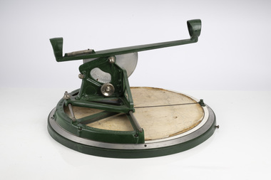
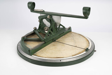
Victoria once had well over one hundred fire lookouts and firetowers. Fire lookouts, or observation posts, were often just a clearing on a hill or a vantage point, whereas firetowers were definite structures. Many were established by the Forests Commission Victoria (FCV) in the 1920s, but the network was expanded rapidly in response to recommendations of the Stretton Royal Commission after the 1939 Black Friday bushfires. When a fire or smoke was spotted from the tower a bearing was taken with the alidade and radioed or telephoned into the district office. It was then cross referenced with bearings from other towers on a large wall map to give a "fix" on the fire location. Alidades and telescopes were used in the post war period but were replaced with a much simpler map table and reference string suspended from the centre of the tower cabin. This "Fire Finder" was used in Canadian fire towers to identify the location of wildfires. The unique design was first developed by the British Columbia Forest Service (BCFS) in the early 1950s. Close examination of the map indicates that this particular Fire Finder may have been once used at Bluejoint Mountain lookout in Granby Provincial Park. This Fire Finder was a gift to Barry (Rocky) Marsden from the British Columbia Forest Service in the late 1980s in recognition of the close relationships that had been forged with the staff at the Altona Workshops over many decades. Fire Finders were originally painted black but this one was repainted green after it arrived at Altona. The BC Forest Service had a large facility where they manufactured Fire Finders and many other items of equipment, but in the 1980s it was shut down. Heavy cast iron circular object with a paper topographic map mounted on it. The metal dial and ruler works similar to a compass. The sight tube is used to determine the bearing and elevation of the fire on the map. This Fire Finder also sometimes known as an Alidade. Its a different design from the Osborne Fire Finder widely used in North American fire lookouts from the 1920s. British Columbia Forest Service. Model 62A. Serial Number 6308.bushfire -
 Department of Energy, Environment and Climate Action
Fire Finder
Victoria once had well over one hundred fire lookouts and firetowers. Fire lookouts, or observation posts, were often just a clearing on a hill or a vantage point, whereas firetowers were definite structures. Many were established by the Forests Commission Victoria (FCV) in the 1920s, but the network was expanded rapidly in response to recommendations of the Stretton Royal Commission after the 1939 Black Friday bushfires. When a fire or smoke was spotted from the tower a bearing was taken with the alidade and radioed or telephoned into the district office. It was then cross referenced with bearings from other towers on a large wall map to give a "fix" on the fire location. Alidades and telescopes were used in the post war period but were replaced with a much simpler map table and reference string suspended from the centre of the tower cabin. This "Fire Finder" was used in Canadian fire towers to identify the location of wildfires. The unique design was first developed by the British Columbia Forest Service (BCFS) in the early 1950s. Close examination of the map indicates that this particular Fire Finder may have been once used at Bluejoint Mountain lookout in Granby Provincial Park. This Fire Finder was a gift to Barry (Rocky) Marsden from the British Columbia Forest Service in the late 1980s in recognition of the close relationships that had been forged with the staff at the Altona Workshops over many decades. Fire Finders were originally painted black but this one was repainted green after it arrived at Altona. The BC Forest Service had a large facility where they manufactured Fire Finders and many other items of equipment, but in the 1980s it was shut down. Heavy cast iron circular object with a paper topographic map mounted on it. The metal dial and ruler works similar to a compass. The sight tube is used to determine the bearing and elevation of the fire on the map. This Fire Finder also sometimes known as an Alidade. Its a different design from the Osborne Fire Finder widely used in North American fire lookouts from the 1920s. British Columbia Forest Service. Model 62A. Serial Number 6308.bushfire -
 Whitehorse Historical Society Inc.
Map, Aerial photographs Nunawading, 1976
Department of Crown Lands and Survey, Melbourne, 1976 Project.Department of Crown Lands and Survey, Melbourne, 1976 Project. Runs 29 - 33 City of Nunawading. Frames numbered from South to North boundaries, each strip numbered from West to East. No index map. Sheets 30/8 and 30/9 missing.non-fictionDepartment of Crown Lands and Survey, Melbourne, 1976 Project. victoria. department of crown lands and survey, aerial photographs, nunawading, mitcham, blackburn, blackburn north, blackburn south, forest hill, vermont, vermont south, burwood east, box hill, ringwood -
Whitehorse Historical Society Inc.
Map, Subdivision of Allotment 122a, 1972
Subdivision of land along Livermore Close and Moore Road, Vermont South.Subdivision of land along Livermore Close and Moore Road, Vermont South. Original survey Rob Poole 1899. Stamp indicates 'Land on this plan is in proclaimed survey No 21. Survey Coordination Act 1940. As from 9 Aug 1972. Two maps in different scales.Subdivision of land along Livermore Close and Moore Road, Vermont South. land subdivision, livermore close, vermont south, moore road, vermont south, dandenong creek -
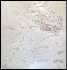 Falls Creek Historical Society
Map - Sun Valley, Falls Creek, 1966
This hand drawn map shows the Gully Chair, Summit Tow and the Village Tow. It also highlights the Nursery Poma. Several buildings can be seen along with the Visitor Centre in the Gully carpark, Skyline can can be seen adjacent to the Gully Chair. The Sun Valley T-Bar was designed by Ron McCallum and began operation in 1967. It had a length of 826 metres and an elevation of approximately 200 metres. In 1989 the Sun Valley T-Bar was replaced by the Scott Quad. Ron McCallum was a founder of Alpine Developments. It appears that his first lift was the Skyline portable tow at Falls Creek in 1954. As an engineer, he went on to build about 20 chairlifts and T-bars in the 1960s and early 1970s including at least five at Falls Creek. This map is significant because it shows plans for the development of a major tow at Falls Creek in the 1960s.A framed black and white concept map for the proposed new lift in Sun Valley, Falls Creek.sun valley tow, ron mccallum, falls creek tows -
 Greensborough Historical Society
Map, Melbourne and Metropolitan Board of Works. Survey Division, MMBW, Yarra 2500 / 12.22. Watsonia North, 1978_03
Melbourne and Metropolitan Board of Works. Yarra 2500 [base map]. 12-22, Parishes of Keelbundora 2856, Municipalities of Whittlesea 239 and Diamond Valley 257. Shows street names, easement sizes, lot numbers, lodged plan numbers, names of prominent features, contour values, creek or river names. Watsonia Railway Station and environs. Prominent streets: Edmund Rice Parade and Macorna Street. Includes Christian Brothers Edmund Rice College and Janefield Special School sites and "proposed future freeway" (now Metropolitan Ring Road).MMBW Map in 1:2500 [scale] series. Cream parchment with green tape reinforcing on edges and punched holes on left edge.mmbw, melbourne and metropolitan board of works, shire of diamond valley, watsonia - maps, bundoora - maps -
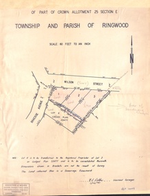 Ringwood and District Historical Society
Document - Plan of Subdivision, Part of Crown Allotment 25 Section E, Township and Parish of Ringwood - 1961
Map showing residential allotments numbered 1, 2, 3 and 4, on Wilson Street and Braeside Avenue, Ringwood East, Victoria.Signed and dated 1/12/1961. Rubber stamped Kirkpatrick & Webber, Licensed Surveyors, Civil Engineers & Town Planners, 225 Maroondah Highway, Ringwood, Telephone 870-0321. Ref 3438C. "Note: Lot 4 is to be transferred to the Registered Proprietor of Lot 2 on Lodged Plan 23477 and is to be consolidated therewith." Map also includes handwritten Estate Agent notations. -
Phillip Island and District Historical Society Inc.
Book, LOVE, Don, Shipwrecks on the South Gippsland Coast, 2005
Maps on endpapers. Includes bibliographical references and indexes.shipwrecks, victoria, south gippsland, history -
Glenelg Shire Council Cultural Collection
Plan - Town Plan - Cape Bridgewater, 02/04/1992
Black and white photocopy of an old plan of a subdivision at Cape Bridgewater. Two halves joined together with sellotape. Black texta numbers on some of the lots 1 - 28Front: 'OLD MAP' handwritten, top edgeplan, town planning, cape bridgewater -
 Ringwood and District Historical Society
Photograph, Land sale brochure map of Ringwood's early main central area around Mount Dandenong Road - c.1880s
Catalogue card reads, 'Map of Ringwood East'. -
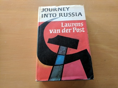 Robin Boyd Foundation
Book, Laurens van der Post, Journey Into Russia, 1964
Hardcover w/ Dust Jacket(Apart from the map that was already part of the book)walsh st library -
 Victorian Aboriginal Corporation for Languages
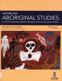
Periodical, Australian Institute of Aboriginal and Torres Strait Islander Studies, Australian Aboriginal studies : journal of the Australian Institute of Aboriginal and Torres Strait Islander Studies, 2008
1. Rock-art of the Western Desert and Pilbara: Pigment dates provide new perspectives on the role of art in the Australian arid zone Jo McDonald (Australian National University) and Peter Veth (Australian National University) Systematic analysis of engraved and painted art from the Western Desert and Pilbara has allowed us to develop a spatial model for discernable style provinces. Clear chains of stylistic connection can be demonstrated from the Pilbara coast to the desert interior with distinct and stylistically unique rock-art bodies. Graphic systems appear to link people over short, as well as vast, distances, and some of these style networks appear to have operated for very long periods of time. What are the social dynamics that could produce unique style provinces, as well as shared graphic vocabularies, over 1000 kilometres? Here we consider language boundaries within and between style provinces, and report on the first dates for pigment rock-art from the Australian arid zone and reflect on how these dates from the recent past help address questions of stylistic variability through space and time. 2. Painting and repainting in the west Kimberley Sue O?Connor, Anthony Barham (Australian National University) and Donny Woolagoodja (Mowanjum Community, Derby) We take a fresh look at the practice of repainting, or retouching, rockart, with particular reference to the Kimberley region of Western Australia. We discuss the practice of repainting in the context of the debate arising from the 1987 Ngarinyin Cultural Continuity Project, which involved the repainting of rock-shelters in the Gibb River region of the western Kimberley. The ?repainting debate? is reviewed here in the context of contemporary art production in west Kimberley Indigenous communities, such as Mowanjum. At Mowanjum the past two decades have witnessed an artistic explosion in the form of paintings on canvas and board that incorporate Wandjina and other images inspired by those traditionally depicted on panels in rock-shelters. Wandjina also represents the key motif around which community desires to return to Country are articulated, around which Country is curated and maintained, and through which the younger generations now engage with their traditional lands and reach out to wider international communities. We suggest that painting in the new media represents a continuation or transference of traditional practice. Stories about the travels, battles and engagements of Wandjina and other Dreaming events are now retold and experienced in the communities with reference to the paintings, an activity that is central to maintaining and reinvigorating connection between identity and place. The transposition of painting activity from sites within Country to the new ?out-of-Country? settlements represents a social counterbalance to the social dislocation that arose from separation from traditional places and forced geographic moves out-of-Country to government and mission settlements in the twentieth century. 3. Port Keats painting: Revolution and continuity Graeme K Ward (AIATSIS) and Mark Crocombe (Thamarrurr Regional Council) The role of the poet and collector of ?mythologies?, Roland Robinson, in prompting the production of commercial bark-painting at Port Keats (Wadeye), appears to have been accepted uncritically - though not usually acknowledged - by collectors and curators. Here we attempt to trace the history of painting in the Daly?Fitzmaurice region to contextualise Robinson?s contribution, and to evaluate it from both the perspective of available literature and of accounts of contemporary painters and Traditional Owners in the Port Keats area. It is possible that the intervention that Robinson might have considered revolutionary was more likely a continuation of previously well established cultural practice, the commercial development of which was both an Indigenous ?adjustment? to changing socio-cultural circumstances, and a quiet statement of maintenance of identity by strong individuals adapting and attempting to continue their cultural traditions. 4. Negotiating form in Kuninjku bark-paintings Luke Taylor (AIATSIS) Here I examine social processes involved in the manipulation of painted forms of bark-paintings among Kuninjku artists living near Maningrida in Arnhem Land. Young artists are taught to paint through apprenticeships that involve exchange of skills in producing form within extended family groups. Through apprenticeship processes we can also see how personal innovations are shared among family and become more regionally located. Lately there have been moves by senior artists to establish separate out-stations and to train their wives and daughters to paint. At a stylistic level the art now creates a greater sense of family autonomy and yet the subjects link the artists back in to much broader social networks. 5. Making art and making culture in far western New South Wales Lorraine Gibson This contribution is based on my ethnographic fieldwork. It concerns the intertwining aspects of the two concepts of art and culture and shows how Aboriginal people in Wilcannia in far western New South Wales draw on these concepts to assert and create a distinctive cultural identity for themselves. Focusing largely on the work of one particular artist, I demonstrate the ways in which culture (as this is considered) is affectively experienced and articulated as something that one ?comes into contact with? through the practice of art-making. I discuss the social and cultural role that art-making, and art talk play in considering, mediating and resolving issues to do with cultural subjectivity, authority and identity. I propose that in thinking about the content of the art and in making the art, past and present matters of interest, of difficulty and of pleasure are remembered, considered, resolved and mediated. Culture (as this is considered by Wilcannia Aboriginal people) is also made anew; it comes about through the practice of artmaking and in displaying and talking about the art work. Culture as an objectified, tangible entity is moreover writ large and made visible through art in ways that are valued by artists and other community members. The intersections between Aboriginal peoples, anthropologists, museum collections and published literature, and the network of relations between, are also shown to have interesting synergies that play themselves out in the production of art and culture. 6. Black on White: Or varying shades of grey? Indigenous Australian photo-media artists and the ?making of? Aboriginality Marianne Riphagen (Radboud University, The Netherlands) In 2005 the Centre for Contemporary Photography in Melbourne presented the Indigenous photo-media exhibition Black on White. Promising to explore Indigenous perspectives on non-Aboriginality, its catalogue set forth two questions: how do Aboriginal artists see the people and culture that surrounds them? Do they see non-Aboriginal Australians as other? However, art works produced for this exhibition rejected curatorial constructions of Black and White, instead presenting viewers with more complex and ambivalent notions of Aboriginality and non-Aboriginality. This paper revisits the Black on White exhibition as an intercultural event and argues that Indigenous art practitioners, because of their participation in a process to signify what it means to be Aboriginal, have developed new forms of Aboriginality. 7. Culture production Rembarrnga way: Innovation and tradition in Lena Yarinkura?s and Bob Burruwal?s metal sculptures Christiane Keller (University of Westerna Australia) Contemporary Indigenous artists are challenged to produce art for sale and at the same time to protect their cultural heritage. Here I investigate how Rembarrnga sculptors extend already established sculptural practices and the role innovation plays within these developments, and I analyse how Rembarrnga artists imprint their cultural and social values on sculptures made in an essentially Western medium, that of metal-casting. The metal sculptures made by Lena Yarinkura and her husband Bob Burruwal, two prolific Rembarrnga artists from north-central Arnhem Land, can be seen as an extension of their earlier sculptural work. In the development of metal sculptures, the artists shifted their artistic practice in two ways: they transformed sculptural forms from an earlier ceremonial context and from earlier functional fibre objects. Using Fred Myers?s concept of culture production, I investigate Rembarrnga ways of culture-making. 8. 'How did we do anything without it?': Indigenous art and craft micro-enterprise use and perception of new media technology.maps, colour photographs, b&w photographswest kimberley, rock art, kuninjku, photo media, lena yarinkura, bob burruwal, new media technology -
Victorian Aboriginal Corporation for Languages
Book, Various Artists, Deadly expressions : profiling contemporary and traditional Aboriginal art from South Eastern Australia, 2004
Curator: Esmai Manahan. Third exhibition in a series titled "Tribal expressions", held in Melbourne, 2004. Includes bibliographical references. colour photographs, b&w photographs, mapsart, arts, victoria, koori, koorie, gallery, exhibition, arts victoria, melbourne, artists -
 Victorian Aboriginal Corporation for Languages
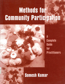
Book, Somesh Kumar, Methods for community participation : a complete guide for practitioners, 2002
A manual for participatory development.maps, b&w illustrations, tables, chartscommunity development, rural development -
 Victorian Aboriginal Corporation for Languages
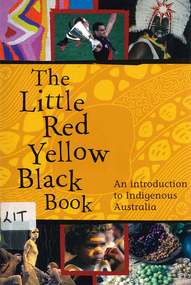
Book, Bruce Pascoe, The little red yellow black book : an introduction to Indigenous Australia, 2008
The Little Red Yellow Black Book is an accessible and highly illustrated pocket-sized guide. It's an invaluable introduction to Australia's rich Aboriginal and Torres Strait Islander histories and culture. It takes a non-chronological approach and is written from an Indigenous viewpoint. The themes that emerge are the importance of identity, and adaptation and continuity. If you want to read stories the media don't tell you, mini-essays on famous as well as everyday individuals and organisations will provide insights into a range of Australian Indigenous experiences.maps, b&w photographs, colour photographsindigenous history, culture, art, sport, health, education, employment, reconciliation, resistance, governance -
 Victorian Aboriginal Corporation for Languages
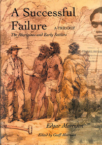
Book, Edgar Morrison, A successful failure, a trilogy : the Aborigines and early settlers, 2002
Tells of the Aboriginal Protectorate System in Colonial Victoria during the period 1838 to 1852. The system was designed to be a buffer between the original inhabitants and the influx of white squatters. That the system failed is of little wonder. This story traces the times of Edward Stone Parker, Assistant Aboriginal Protector in the Loddon region of Victoria.maps, b&w photograph, colour photographs -
 Victorian Aboriginal Corporation for Languages
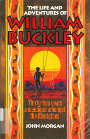
Book, John Morgan, The life and adventures of William Buckley, 1996
Early (1852) biography of William Buckley, with introduction and notes by Roland Schicht (1996).maps, b&w illustrations, colour illustrationsport phillip bay, yarra river, william buckley -
 Victorian Aboriginal Corporation for Languages
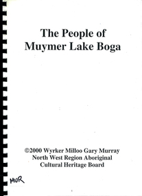
Book, Wyrker Milloo Gary Murray, The people of Muymer Lake Boga, 2000
word lists, maps, public records listslatje latje, ladji ladji, wadi wadi, yapagulk, wemba wemba, baraparap, dja dja wurrung -
 Victorian Aboriginal Corporation for Languages
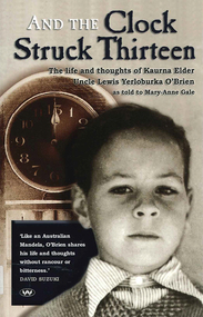
Book, Lewis Yerloburka O'Brien, And the clock struck thirteen : the life and thoughts of Kaurna Elder Uncle Lewis Yerloburka O'Brien /? as told to Mary-Anne Gale, 2007
The story of Kaurna man Uncle Lewis O'Brien and his family, beginning with his great, great grandmother Kudnarto - the first Aboriginal woman to marry a white man in South Australia. Contents: 1: Padniadlu wadu: Let's walk together in harmony 2: Kudnarto of Skillogalee Creek 3: Who was Tom Adam senior? 4: Tom and Tim Adams of Poonindie 5: The Adams Family of Point Pearce mission 6: Treasured memories and lessons from the mission 7: My difficult childhood 8: Leaving school and doing an apprenticeship 9: Joining the Merchant Navy 10: Becoming a 'land-lover' and settling down 11: Reflections on working in schools and university 12: Sharing our space 13: Achievements and celebrations.colour photographs, maps, b&w photographskaurna, south australia, political activism -
 Victorian Aboriginal Corporation for Languages
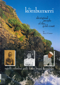
Book, Rory O'Connor, The Kombumerri : Aboriginal people of the Gold Coast, 1992
Comprehensive book with coloured photos of the Kombumerri people and their traditional life in Queensland?s Gold Coast. Tells of white settlement, historic sites, flora and fauna, customs and myths, repression and land.colour photographs, b&w photographs, mapskombumerri, gold coast, queensland -
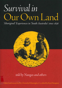 Victorian Aboriginal Corporation for Languages
Book, Christobel Mattingley, Survival in our own land : 'Aboriginal' experiences in 'South Australia' since 1836 : told by Nungas and others, 1998
A history of Aboriginal experiences in 'South Australia' since 1836.maps, b&w photographs, document reproductionssouth australia, nunga, goonya, colonisation -
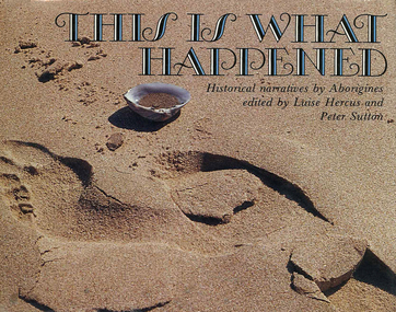 Victorian Aboriginal Corporation for Languages
Book, Luise Hercus, This is what happened : historical narratives by Aborigines, 1986
This book is devoted to the contact history of a hunting and gathering people where they themselves tell the stories in their own languages. Presented as transcriptions of the original stories in Language in facsimile with introductions, gloss and translations by the transcribers. Contains stories by B. Kerwin, R. Moses, H.P. Kulambunt. B. Roberts, M.M. Irinjili D. Harris, J.S. Karntin, C.G. Wurramarrba, Barrengwa, B. Murray, W. Clegg, S. Day, T. Ejai, A. Baranga, I. Joshua, B. Clarmont and C. Omeenyo, H. Goetz, A. Coulthard, J. Boxer; (Lalarin), B.A. Sommer, J. Jack, E. Kennedy, L.J. Kyngayari, V. Lingiari, J.C. Maliwanga and J. Flinders, separately annotated.maps, b&w photographs, word listsyandruwandha, innamicka, nicholson river, djaru, wawarl, western dialect, murinypata, alawa, mission, wangganguru, ngiyambaa, cobar, cape keerweer, wik-ngatharra, macassar, anindilyakwa, dhirari, afghan, chinaman, wagaya, wemba wemba, bilikin brothers, bardi, ngarinjin, massacres, hodgson downs, warndarang, mindiri, wangganguru, old paddy, umpila, native police, gugu-badhun, boninb, atynyamatana, constable mcleay, bowman, oykangand, kukatj, roper creole, paradise, dhirari, fanny brown, wave hill strike, gurindji, vincent lingiari, mainoru station, rembarrnga, land rights, flinders island -
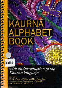 Victorian Aboriginal Corporation for Languages
Book with CD, Kaurna alphabet book : with an introduction to the Kaurna language, 2006
Maps, colour photographs, word lists, CDkaurna, kaurna plains school