Showing 6645 items matching "marks "
-
 Mont De Lancey
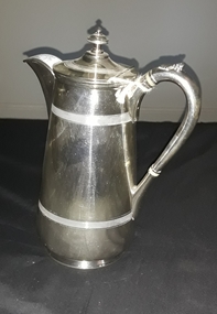
Domestic object - Coffee pot, ca.1900's
Wedding gift to Mrs William Smith from Mr and rs W J Sebire 1933Silver patterned coffee pot with handle and hinged lid. Handle has two milk glass bands with a shell decoration on top.Makers mark - Trumpet EPBM 8487 Made in Englandcofeepots -
 Mont De Lancey
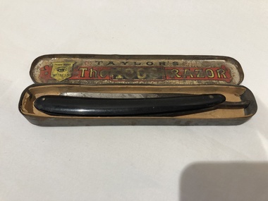
Razor, Neeham, Veal and Tyzack, Circa 1880
Early English, Cut throat razor with black bakelite handle in metal case."Taylor's Trade Mark Witness The 1008 Razor Regd.cut-throat razors -
 Melbourne Legacy
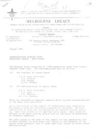
Document, Administrative Working Party Melbourne Legacy - Task Force
This document discusses the many options available to Melbourne Legacy in matters such as:- A) Disposal of Legacy House (293 Swanston St, Melbourne), redeveloping the existing site, selling the building and remain as a tenant or moving to another location. Many variations of these options are discussed. B) Whether Legacy luncheons would or should continue, would any of the above options reduce widow visits to Legacy House. C) Matters that would influence the sale price and/or costs of alterations. D) Reasons for/against various options E) Recommendations. There are 5 recommendations in total. The above items are followed up by some observations during the discussions but not central to the brief. A precis of items from submissions relating directly or indirectly upon the disposal of Legacy House A report regarding salary and staffing levels levels, the number of committtees, staff organization and Legatees interactions with staff employed by Legacy. This is followed up by several recommendations. At the time entering the above information 14/9/2018 Legacy House has not been sold but some of the floor space has been rented out. Much of what is discussed in this report (August 1984) is about making the Legacy dollar go further and any positive/adverse effects on the primary purpose of taking care of the widows and the efficient running of Melbourne Legacy. White quarto paper with black type, 14 pages about an administrative working party taskforce.Various notations/marks in pencil, ink, highlighter throughout. properties, staff, dureau house -
 Clunes Museum
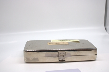
Equipment - INTUBATION SET
USED IN FORMER HOSPITALMETAL BOX CONTAINING [ON LID] INTUBATION SET - STAINLESS STEEL [IN THE BOX] THE MEASURING RULER- STAINLESS STEEL, & THE BRASS FITTINGS OF VARIOUS SIZES.THE LARGER BRASS FITTING WITH ROUNDED ENDS ALSO HAVE STRINGS ATTACHED.1 ON INTUBATER & SMALLER FITTINGS; MEASURING MARKS ON RULERlocal history, medical, surgery -
 Melbourne Tram Museum
Legal record, Melbourne & Metropolitan Board of Works (MMBW), "Agreement General Mains - Hawthorn Tramways Trust", 14/10/1914 12:00:00 AM
Legal document within a light brown manila document - titled "Agreement General Mains - Hawthorn Tramways Trust", giving the agreement to redesign and reconstruct water and sewerage pipes affected by the construction of tram tracks. Gives conditions, the schedule of works, locations and signed by the HTT members with an affixed embossed seal and the MMBW with embossed seal. Folder has file number "No. 293 - "Agreement General Mains - Hawthorn Tramways Trust"" written on the outside.Has some pencil marks underlying a particular clause.trams, tramways, hawthorn, mmbw, tramways, construction, htt, services -
 Melbourne Tram Museum
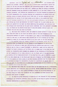
Document - Report, Road Traffic Authority, "Central Area Transport Study", Dec. 1988
Report - 108 pages + card cover, centre stapled, titled "Central Area Transport Study", produced by the Road Traffic Authority as part of the Central Area Transport Strategy (CATS), with a forward by the Minister for Transport Jim Kennan, has a table of contents, figures and tables. Provides a set of Action Plans, looks at future development areas around Melbourne, options, roads, tram and rail lines, cycle and pedestrians. Draft document. See Reg Item 1582 for a March 1991 version.Has pen marks high lighting various paragraphs.trams, tramways, public transport, melbourne, road transport, the met, minister for transport -
 Eltham District Historical Society Inc
Photograph, Fitzsimons Lane Bridge over Yarra River between Eltham and Templestowe, c.1966, 1966c
The bridge over the Yarra River was initially opened September 22nd, 1961. Newspaper reports at the time of opening stated it linked Bolton Street, Eltham, with Fitzsimons Lane, Templestowe. In 1955 the Country Roads Board (CRB) produced survey plans that showed proposed land acquisition for the future bridge and road approaches. The 1955 plan shows that it was proposed to connect Fitzsimons Lane with Bolton Street in Eltham by a diagonal road across the river. The road connection would then continue along Bolton Street to Main Road. Prior to construction of the bridge the CRB modified the proposal significantly so that there was a new road parallel with Bolton Street and then curving to join Main Road at what was then its intersection with Old Eltham Road. This involved significantly more land acquisition and altered the pattern of land subdivision through this corridor. Initially the new road was just a single two-way carriageway as it would have required a significant widening of the cutting on the Shire of Eltham side of the river. The road was officially un-named but was known locally as the Eltham-Templestowe Road. The 1966 Melway street directory and other 1960s editions also listed the road as the Eltham-Templestowe Road. In December 1970, Eltham Shire Council, in pursuance of the provisions of the Local Government Act, named it Templestowe Road. The road was renamed Fitzsimons Lane around 1984 in conformity with the section south of the river. In 1991 a new bridge was built to the west of the original bridge. Fitzsimons Lane was widened to four traffic lanes although on the Eltham side this was done within the limits of the existing cutting. NEW BRIDGE STARTS THEM EXPLORING Without any fanfares, Country Roads Board workmen on Friday afternoon put the finishing touches to the approaches, removed the barricades, and let the traffic roll over the new Yarra bridge linking Bolton Street, Eltham, with Fitzsimons Lane, Templestowe. Over the week-end many “bridge watchers” who were making one of their periodic inspections of the progress on the new bridge found to their surprise that they could drive over it, so that people who had gone for a run out to Eltham suddenly found themselves wandering through Templestowe and Doncaster. By Monday the word of the bridge’s opening had got around sufficiently for many regular travellers to the city from Eltham and beyond to vary the monotony by going to town via Templestowe and Kew instead of through Heidelberg. They were surprised at the distances – about 3 ½ miles from Eltham to Templestowe, 6 miles from Eltham Shire hall to the Lower Heidelberg Road-Banksia Street intersection. NEW NEIGHBOURS For people on both sides of the river, the new bridge has turned distant friends into near neighbours. A Greensborough man on Sunday took 35 minutes to reach the home of a friend in East Doncaster, but the return trip over the new bridge took only 17 minutes. It will be some time yet before most people work out the possibilities in shorter and quicker trips form the north-eastern areas to the eastern and south-eastern suburbs. The coming of the warmer months will soon teach many, though the short cuts to Peninsular beaches and eastern suburban drive-ins. And before very long it is likely there will be a Tramways bus running from Templestowe to Eltham station. NEW BRIDGE STARTS THEM EXPLORING (1961, September 27). The Diamond Valley News (News clipping held in SEA_74-1_047) The previously un-named road between Main Road and Yarra River, Eltham South, east of Bolton Street was named Templestowe Road, December 15, 1970 NAMING OF STREETS AND ROADS. (1970, December 15). The Diamond Valley News (News clipping held in SEA_74-2_022)Black and white photographManufacturer's marks: Polaroid, Batch #J62K181 (Sep 1966).infrastructure, shire of eltham infrastructure, bridge, fitzsimons lane bridge, polaroid, yarra river -
 Vision Australia
Equipment - Object, Apollo Brailler Mark II, 1979-2005
Designed by Nimoka (Nippon Moujin Youga Kaihatsu), it was produced between 1979-2005. A heavy Braille writer for its size, the Apollo provides a standard typewriter style albeit with the oblong keys sitting to the left hand side of the brailler. The design easily fits within a small musical instrument style case, and consists of a rectangular shaped structure made out of metal base with black coloured keys and a grey coloured soft plastic cover. Underneath a battery compartment (which powers a bell) is kept closed with a capped screw.Black and green metal object with covering boxApollo Brailler Mark-II (Serial number) 834400braille equipment, assistive devices -
 National Vietnam Veterans Museum (NVVM)
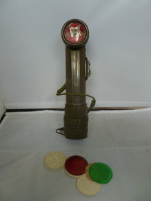
Equipment - Torch, angle-head
Collected by National Serviceman Pte D J Kerslake from the site of an ambush initiated by 1 RAR in 1968Olive green plastic with coloured filters stored in handle. The torch is modified in that the front red plastic filter has a star shape cut out of it to identify it as Viet Cong for night identification.MX 9914.0 Bright star, Trade mark reg.torch, flashlight, vietnam war, viet cong, north vietnamese, nth vietnamese, field torch -
 Bendigo Historical Society Inc.
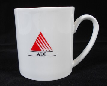
Ceramic - Australian Defence Industries (ADI) three ADI mugs
Australian Defence Industries (ADI) three ADI mugs. a) White mug with ADI (black lettering) and Red ADI "sail" emblem b) cream mug with black lettering "Australin Defence Industries Pty Ltd Bendigo (054) 40 4311 circles a green / cream triangular symbol. No maker's is identified. Some minor chips to rim and to interior. c) cream with thick blue upper section with blue extending half handle. ADI emblem with "Bendigo " written below plus "5s + 1". a) Aria, porcelain made in Australia by Australian fine china b) no maker's mark c) maker's mark on base - Bendigo Pottery est. 1858local history, adi history -
 Ballarat Tramway Museum
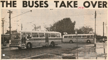
Newspaper, The Courier Ballarat, "Buses Take Over", 24/08/1971 12:00:00 AM
Newspaper clipping pasted onto a single sheet of paper with two Punch holes on the left hand side with one hole through the photograph within the cutting. Clipping from The Courier, Ballarat, 24/8/1971, with a photo of two Davis Bus Line buses travelling in Sturt and Drummond St., with a bus stop sign in the foreground and white marks around former tram stop signs on poles. Caption notes the buses replaced trams servicing Victoria St and the Gardens via Drummond St. North and that other services will be replaced over the next four weeks.In red ink in upper central right hand corner, "24/8/71" On sheet of paper, various ink marks and 1963/4 dates. Possibly paper used by Donor at his job with the former machinery makers, Ronaldson and Tippet.trams, tramways, closure, bus changeover, drummond st., sturt st. -
 Bendigo Military Museum
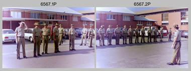
Photograph - 4th Field Survey Squadron ANZAC Day Parade. Adelaide, SA, 1994
This is a set of 11 photographs of 4th Field Survey Squadron personnel at Keswick Barracks preparing for the ANZAC Day parade through the streets of the Adelaide CBD on the 25th of April 1994. The march concluded at the Cross of Sacrifice in Pennington Gardens East followed by the ANZAC Day Service of Remembrance. Photos were also taken at Keswick Barracks at the end of the parade. See items 6565.32P and 6566.14P for more photos taken during ANZAC Day, 1994.This is a set of 11 photographs of 4th Field Survey Squadron personnel on ANZAC Day, on the 25th of April 1994. The colour photographs are on 35mm negative film and are part of the Army Survey Regiment’s Collection. The photographs were scanned at 96 dpi. .1) - Photo, colour, 1994. Unit sizing drill. L to R: CPL Brett Parkin, CPL Jeremy Archer, SGT Dave Longbottom, SPR Mark Sinderberry, SGT H. Evertz, SPR Matt Arnold, unidentified. .2) - Photo, colour, 1994. Unit sizing drill. L to R: unidentified (x5), SPR Chris Pearse, unidentified (x4), SPR Fran Calvert, SSGT Pat ‘Fuji’ Drover. .3) - Photo, colour, 1994. Unit sizing drill. L to R: CPL Brett Parkin, SPR Mark Sinderberry, unidentified, SPR Mark Linwood, remainder unidentified. WO2 Peter Hammer (far right). .4) - Photo, colour, 1994. Unit sizing drill. L to R: CPL Brett Parkin, SPR Mark Sinderberry, unidentified, SPR Mark Linwood, CPL Jeremy Archer, remainder unidentified. .5) - Photo, colour, 1994. Unit sizing drill. L to R: CPL Brett Parkin, unidentified (x2), SPR Mark Sinderberry, SPR Mark Linwood, remainder unidentified. .6) - Photo, colour, 1994. Unit sizing drill. L to R: unidentified (x4), SPR Mark Linwood, unidentified (x5), SPR Mark Sinderberry, remainder unidentified. .7) - Photo, colour, 1994. Unit uniform inspection. .8) - Photo, colour, 1994. Unit uniform inspection. L to R: unidentified, SPR Mark Linwood, SGT H. Evertz, SPR Mark Sinderberry, remainder unidentified. .9) - Photo, colour, 1994. Unit gathering post-parade. L to R: CPL Brett Parkin (partially obscured), SPR Greg Richards, SPR Mark McInerney. .10) - Photo, colour, 1994. Unit gathering post-parade. L to R: unidentified, Darby Munro (facing away), unidentified, John Harrison, SSGT John ‘Shep’ Shephard, unidentified (x2), SPR Fran Calvert, CPL Steve Wegener, remainder unidentified. .11) - Photo, colour, 1994. Unit gathering post-parade. L to R: Darby Munro, unidentified (x2), John Harrison, unidentified (x3), SPR Fran Calvert, unidentified (x2), SSGT John ‘Shep’ Shephard..1P to .11P – There are no personnel identified. ‘1994 ANZAC DAY’ annotated on negatives sleeve.royal australian survey corps, rasvy, 4 fd svy sqn -
 Ballaarat Mechanics' Institute (BMI Ballarat)
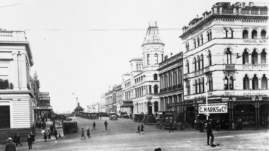
Craigs Hotel circa 1940s
... Marks ...This photograph is from the Max Harris Collection held by the Ballaraat Mechanics' Institute. Please contact BMI for all print and usage inquiries.ballarat, craigs hotel, 1940s, lydiard, sturt, marks, wattle, purdue -
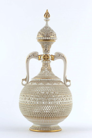 Benalla Art Gallery
Ceramic, WORCESTER ROYAL PORCELAIN, Reticulated vase and cover, c. 1900
Established: Worcester, Worcestershire, England in 1751 by Dr John Wall and William DavisVictorianLedger Bequest, 1993Vase of pierced porcelain with two handles and decorated with gilding.Verso: ROYAL WORCESTER ENGLAND maker's mark in gold centre of base; "871" in gold under maker's mark; "G owen" inscribed below maker's mark; " 61" in black underglaze below inscription; "1K" stamped into base on right of inscription.vase, ceramic, handles, intricate modelling, gilded, worcester -
 Bendigo Historical Society Inc.
Administrative record - Kangaroo Flat Red Cross Collection: General meeting minute book. April 1973 to August 1987
BHS CollectionRed cover with gold embossed inscription. Lined pages inside with handwritten notes. Kangaroo Flat Red Cross Minute book containing minutes of general meetings held monthly at various halls. Kangaroo Flat Branch of the Australian Red Cross Society Victorian division.Inside front cover and inside back cover each have two small sticky tape marks. 7 blue pen marks on calendar inside back cover. One blue pen mark near spine on inside front cover.kangaroo flat, red cross, minutes -
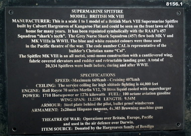 Bendigo Military Museum
Weapon - AEROPLANE, SPITFIRE, Calvert Hargreaves
This item is on display in the gardens of the Bendigo District RSL Sub Branch Havilah Road. Refer photo .1) re its manufacture, history and use..1) Plaque black metal on a stand with white text with details of the item. .2) Scale replica of a Supermarine Spitfire Fighter Mark V111 with markings."Lest we Forget" - "CAL"brsl, smirsl, bdrslinc, replica, spitfire -
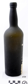 Flagstaff Hill Maritime Museum and Village
Container - Bottle, 19th century
Historic context for this item is currently unavailable. The item at this time cannot be associated with an historical event, person or place and its provenance is unable to be determined at this time. The item is assessed as a Flagstaff Hill Collection asset as a handmade bottle made in the 19th century.Bottle, large, English Ale, dark green glass, cork and wire seal (missing), handmade, crude turn marks on neck, some encrustation. flagstaff hill, warrnambool, shipwrecked-coast, flagstaff-hill, flagstaff-hill-maritime-museum, maritime-museum, shipwreck-coast, flagstaff-hill-maritime-village, bottle, handmade bottle, dark green glass -
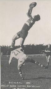 Phillip Island and District Historical Society Inc.
Photograph, 1955
One of a collection of over 400 photographs in an album commenced in 1960 and presented to the Phillip Island & Westernport Historical Society by the Shire of Phillip IslandPhotograph of Phillip Island Football Captain Bob Watson taking a mark during a football match in 1955. Uncle to Essendon Star Tim Watson.local history, photographs, bob watson playing football, black & white photograph, bob watson, bass valley wonthaggi district football league, phillip island football club captain bob watson, john jenner, bryant west -
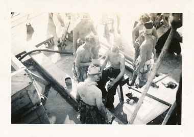 Mission to Seafarers Victoria
Photograph - Photograph, Black and white, Allan Charles Quinn, Crossing the line on the Ariston, 10 September 1946
"Crossing the line" ceremonies were routinely conducted when a crew member made their first crossing of the equator. This photograph depicts aspects of that ceremony and, as Allan Charles Quinn is the photographer, it is obviously not his first crossing. This photograph was exhibited by the Mission to Seafarers as part of the exhibition "Letters from Abroad" in 2012.This photograph is from the Allan Charles Quinn collection which is a collection of letters and photographs depicting aspects of the life of a young man who went to sea in the period immediately following World War II.Black and white photograph depicting aspect of the "crossing the line" ceremony performed at sea on the Ariston. This ceremony was performed to mark a person's first crossing of the equator.Black ink on reverse: Crossing the equator 10.9.46allan-charles-quinn, crossing-the-line, sweden, central-america, north-west-indies, south-america, equator, ariston, letters-from-abroad -
 Glenelg Shire Council Cultural Collection
Letter - Letter - Mark Master Masons to Syd Cuffe, 13/12/1988
Syd Cuffe was the Portland Town Crier from 1983 to 2013. The role of Town Crier was created for Syd Cuffe in 1983 in the lead up to Portland’s 150th anniversary celebrations held in 1984-85. 200 items from Mr. Cuffe’s estate were donated to the Glenelg Shire Cultural Collection. The items relate to his town crying activities and community work across the Shire and further afield.Letter to Syd Cuffe from the United Grand Lodge of Mark Master Masons of Victoria, congratulating him on his Portland Citizenship Award, 1985Front: Signatures of Grand Master and Grand Secretaryportland town crier, town crier, syd cuffe, masons -
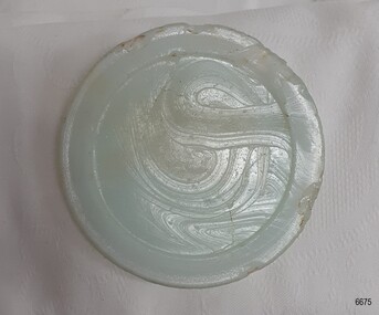 Flagstaff Hill Maritime Museum and Village
Functional object - Cap Liner, ca 1908
A cap liner is an item that helps to seal the contents in a container to avoid the product leaking and sspoiling. This cap liner was recovered from the Falls of Halladale shipwreck. The Falls of Halladale was an iron-hulled, four-masted barque, used as a bulk carrier of general cargo. She left New York in August 1908 bound for Melbourne and Sydney. In her hold was general cargo consisting of roofing tiles, barbed wire, stoves, oil, and benzene as well as many other manufactured items. After three months at sea and close to her destination, a navigational error caused the Falls of Halladale to be wrecked on a reef off the Peterborough headland on the 15th of November, 1908. The captain and 29 crew members survived, but her cargo was largely lost, despite two salvage attempts in 1908-09 and 1910. The Court of Marine Inquiry in Melbourne ruled that the foundering of the ship was entirely due to Captain David Wood Thomson's navigational error, not too technical failure of the Clyde-built ship. The Falls of Halladale was built in1886 by Russell & Co., at Greenock shipyards on the River Clyde, Scotland for Wright, Breakenridge & Co of Glasgow. She was one of several designs of the Falls Line of ships named after waterfalls in Scotland. The company had been founded between 1870- 1873 as a partnership between Joseph Russell, Anderson Rodger, and William Todd Lithgow. During the period 1882-92 Russell & Co. standardised designs, which sped up their building process so much that they were able to build 271 ships during that time. The Falls of Halladale had a sturdy construction built to carry maximum cargo and was able to maintain full sail in heavy gales, one of the last of the 'windjammers' that sailed the Trade Route. She and her sister ship, the Falls of Garry, were the first ships in the world to include fore and aft lifting bridges. Previous to this, heavily loaded vessels could have heavy seas break along the full length of the deck, causing serious injury or even death to those on deck. The new raised catwalk-type decking allowed the crew to move above the deck in stormy conditions. The Falls of Halladale shipwreck is listed on the Victorian Heritage Register (No. S255). She was one of the last ships to sail the Trade Routes. She is one of the first vessels to have fore and aft lifting bridges. She is an example of the remains of an International Cargo Ship and also represents aspects of Victoria’s shipping industry. The wreck is protected as a Historic Shipwreck under the Commonwealth Historic Shipwrecks Act (1976).Glass cap liner, milky-blue moulded disc with indented ring and swirly marks in the glass surface. Recovered from Falls of Halladale wreck. flagstaff hill, warrnambool, shipwrecked-coast, flagstaff-hill, flagstaff-hill-maritime-museum, maritime-museum, shipwreck-coast, flagstaff-hill-maritime-village, falls of halladale, cap liner, russell & co., glass liner, glass seal -
 Ringwood and District Historical Society
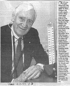
Newspaper, Scrapbook Clipping, Library Collection, Ringwood, Victoria
Newspaper Clipping from "The Mail", 2-12-97. P3. Dr Blair Widmer marks 50 years practicing as a doctor in the Ringwood area.Dr Blair Widmer was honoured for having spent 50 years as a GP in the Ringwood area. The occasion was marked by an afternoon tea at the Uniting Church Hall in Greenwood Ave. -
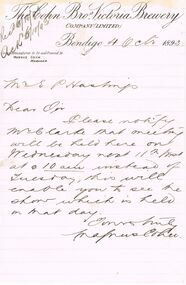 Bendigo Historical Society Inc.
Document - COHN BROTHERS COLLECTION: HANDWRITTEN LETTER DATED 1893
Letter dated 4th Oct 1893 from Magnus Cohn to Secretary. Paper also has a Water Mark, StJames Air-dried Vallum.bendigo, industry, cohn bros brewery -
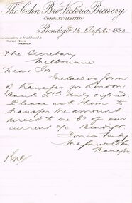 Bendigo Historical Society Inc.
Document - COHN BROTHERS COLLECTION: HANDWRITTEN LETTER DATED 1893
Letter dated 16th Sept 1893 to Secretary from Magnus Cohn. Paper also has a Water Mark St.James Air-Dried Vellum.bendigo, industry, cohn bros brewery -
 Victorian Interpretive Projects Inc.
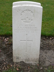
Photograph - Colour, Mark Banning, Photograph of the gravestone of John A. Alexander, 2014, 18/02/2014
John Austin Anderson was the son of Daniel William and Elizabeth Jane Anderson, and husband of Ethel M. Anderson of 312 Ripon Street South, Ballarat. John Anderson was a sergeant with the 2nd Australian Tunnelling Company. He was 34 years of age when he was killed in action in France on 01 July 1916. Anderson is buried at Cite Bonjean Military Cemetery, Armentieres.Four digital images images of the headstones for J.A. Anderson in the Cite Bonjean Military Cemetery, Armentieres, taken by Mark Banning on 18 February 2014. world war one, wwi, war, cemetery, headstone, alexander, j.a. alexander., mmm -
National Vietnam Veterans Museum (NVVM)
Document, Memorabilia of Jason Cowland
Contains 4 AATTV book marks; 1x AP BAC b/w drawing; 5 Unites States Armed Forces Vietnam envelopes.aattv, united states armed forces - stationery -
Tatura Irrigation & Wartime Camps Museum
Book, Methodist Church of Kyabram Jubilee, 1923 copied 2009
Book published to mark the jubilee of the Methodist Church in the Kyabram circuit. 1874 - 1923. Published 1923. Photographs included. Also some honour rolls.methodist church kyabram, kyabram methodist church jubilee