Showing 11140 items matching "planning "
-
 City of Kingston
Pamphlet - Colour, Duffus Bros, Railway Reserve Highett, c. 1923
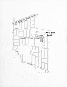
Sales plan for land in the suburb of Highett, titled Railway Reserve, incorporating properties along Wolseley Street, Livingston Street, Highett Road and Worthing Road. The developing urban area of Highett within the City of Kingston. This land sale pamphlet illustrates the subdivision of land within the municipality and the changing demographic of the district as new houses and shops are constructed close to infrastructure.Colour pamphlet advertising thirty eight shop and villa sites for sale at the Railway Reserve, Highett. Incorporates a map of the reserve with properties available on Wolseley Street, Livingston Street, Highett Road and Worthing Road. Handwritten in grey pencil: assumed sale price recorded on subdivisions 1-7, 10, 22, 23 and 34 Handwritten in grey pencil on subdivision 4: C. Nevill / City of Melbourne bank Handwritten in grey pencil across subdivision 7: 49' Handwritten in grey pencil across subdivision 21 and 22: 134' Handwritten in grey pencil across subdivision 25 and 26: 200' Handwritten in grey pencil across subdivision 36 and 37 and both top and bottom: 120' Hand drawn in blue pencil: outline of subdivision 4 Hand drawn in blue pencil: outline of subdivisions 7, 23, 28, 37, 38 along left hand side, subdivisions 38, 37 and 36 on Wolseley Street, subdivisions 30 and 29 along Wolseley Street, subdivisions 29 and 24 along the middle of the plan, subdivisions 24 and half of 25 along Livingston Street, half of subdivision 20 along the middle of the plan, subdivisions 21 and 22 along the Right of Way between Livingston Street and Highett Road, and along the right hand border of subdivision 7. Handwritten in ink adjacent to the subdivision plan, updside down, in the bottom right hand corner: 276 / 54 / 280 / 45 / 320 / 202 / 200 / 134 / horizontal line / 11/14 Handwritten in ink adjacent to the subdivision plan, updside down, in the bottom right hand corner: 1714)2200(15 / 1714 / horizontal line / 486land sales, highett -
 Kew Historical Society Inc
Plan - Subdivision Plan, 10 Fine Villa Sites: Ermington Estate, Kew Heights, ca. 1917
Pru Sanderson, in her groundbreaking ‘City of Kew Urban Conservation Study : Volume 2 - Development History’ (1988), summarised the periods of urban development and subdivisions of land in Kew. The periods that she identified included 1845-1880, 1880-1893, 1893-1921, 1921-1933, 1933-1943, and Post-War Development. These periods were selected as they represented periods of rapid growth or decline in urban development. An obvious starting point for Sanderson’s groupings involved population growth and the associated economic cycles. These cycles also highlighted urban expansion onto land that was predominantly rural, although in other cases it represented the decline and breakup of large estates. A number of the plans in the Kew Historical Society’s collection can also be found in other collections, such as those of the State Library of Victoria and the Boroondara Library Service. A number are however unique to the collection.The Kew Historical Society collection includes almost 100 subdivision plans pertaining to suburbs of the City of Melbourne. Most of these are of Kew, Kew East or Studley Park, although a smaller number are plans of Camberwell, Deepdene, Balwyn and Hawthorn. It is believed that the majority of the plans were gifted to the Society by persons connected with the real estate firm - J. R. Mathers and McMillan, 136 Cotham Road, Kew. The Plans in the collection are rarely in pristine form, being working plans on which the agent would write notes and record lots sold and the prices of these. The subdivision plans are historically significant examples of the growth of urban Melbourne from the beginning of the 20th Century up until the 1980s. A number of the plans are double-sided and often include a photograph on the reverse. A number of the latter are by noted photographers such as J.E. Barnes.In November 1917, the Ermington Estate was advertised as an ‘Executor’s Sale’. It included the 10-roomed villa residence, ‘Ermington’, home of the late Mrs. Lorimer, and 10 ‘magnificent allotments’. The plan in the Kew Historical Society Collection is a little more specific. Ermington is described as having 9 Rooms &c. and there are 11 lots shown on the west side of Hillcrest Avenue. In the plan, the latter is named as ‘Hill Crest Avenue’. The plan indicates that the subdivision was based on the surveying work of Johnson & Tait. Opposite Ermington, the existing house ‘Parkhill’ is identified. A faded stamp on two parts of the plan indicates that it was in the possession of Jas. [R.] Mathers, Financial Agent, [136] Cotham Road, Kew.subdivision plans - kew, ermington heights estate - kew heights -
 Ringwood and District Historical Society
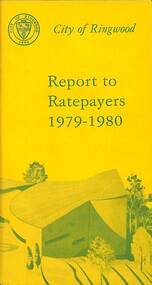
Booklet, City of Ringwood Report to Ratepayers 1979-1980, 1979
Yellow covered community information booklet for Ringwood residents covering Council and Parliamentary contact details, Council Meeting Dates, Justices of the Peace, Council Finances, Immunizations, Major Works, Planning (Live Theatre/Functions Centre, including Floor Plan), Health and Community Services, Christmas Holiday Play Centres, Lord Mayor's Children's Camp, Rates, Municipal Elections, Dogs, Rubbish Tip, Overhanging Foliage, Vandalism, Building By-laws, Ringwood Library (28 Warrandyte Road), Golf Course, Fred Dwerryhouse Swimming Centre, Netball Complex, Growth of Ringwood Commercial Centre, McAlpin's Reserve Development Plan, Netball Complex, Citizenship Ceremonies, Mini Bikes, School Crossing Supervision, Family Fun Day, Highland Carnival. Includes three City of Ringwood Free Tipping Vouchers valid until the end of 1980 and list of tip charges from October, 1979.Mayor's Message - Cr. P. Gotlib. Inside front cover - Green tinted photograph of Ringwood Memorial Tower captioned: Ringwood - "A Happening Community". Back cover - Green and yellow diagram of Ringwood Civic Centre Development, Stage 2. Floor Plan and description of Theatre and Functions Centre expected to be completed by early 1980.rinx -
 Surrey Hills Historical Society Collection
Document - Plans, Andrew Wood, Building plans associated with Andrew Wood, builder of Surrey Hills, 1920s
These plans were associated with Mr Andrew Wood, a contract builder who worked in the 1920s and built many Californian bungalows in Surrey Hills and surrounding suburbs. Andrew Wood was born in Chiltern in 1861 to Andrew and Ellen Wood (MS: Green). His father had emigrated from Falkirk, Scotland. As a young man Andrew worked as a carpenter in the mines in South Africa (c 1899). He married Eleanor Agnes Stuchbery in Hamilton, Victoria in May 1901. They had 5 children - Doris (M Roberts), Robert Andrew, Donald Allen, Jean (M Cowan), and Gwenyth (M Bray). The first 2 children were born in Hawthorn; the other 3 in Surrey Hills. The family home at 286 Canterbury Road, Surrey Hills (on the corner of Middlesex Road) was built by Andrew. Andrew died in 1940; Eleanor died in 1977, aged 100 years. After Eleanor's death the house was sold and demolished. Surrey Lighting was established on the site. Gwenyth May Wood (3 May 1917, Surrey Hills - 5 Jan 2004) married Leslie David Charles Bray (1921-1983). Gwenyth was the donor's mother. Andrew, Eleanor and one son Robert are buried in Box Hill Cemetery - B-071-0028. .1: Specifications & plans for the kinder hall, Howard Street, Mont Albert for the Mont Albert Methodist Church, May 1925 .2 Plans for a proposed villa, 48 Payne's Paddock, Highfield Road, Canterbury for Mr E H Sillifant, dated 22/4/1920 .3 Plans for a timber villa for Mrs J A Burchell at Riversdale Road, Surrey Hills, stamped 9/5/1922 .4 Plan of a garage at Victoria avenue, Canterbury; stamped 14/2/1922 .5 Building permit & receipt from City of Hawthorn re Lot 16 Homebush Crescent; dated 7/4/1925 .6 Plans for a concrete house at Camberwell for Mr H W Field andrew wood, builders, box hill cemetery, kindergartens, mont albert methodist church, building plans, highfield road, ernest horatio sillifant, victoria avenue canterbury, lot 16 homebush crescent, californian bungalows, h w field -
Whitehorse Historical Society Inc.
Map, Subdivision of Allotment 122a, 1972
Subdivision of land along Livermore Close and Moore Road, Vermont South.Subdivision of land along Livermore Close and Moore Road, Vermont South. Original survey Rob Poole 1899. Stamp indicates 'Land on this plan is in proclaimed survey No 21. Survey Coordination Act 1940. As from 9 Aug 1972. Two maps in different scales.Subdivision of land along Livermore Close and Moore Road, Vermont South. land subdivision, livermore close, vermont south, moore road, vermont south, dandenong creek -
 Ringwood and District Historical Society
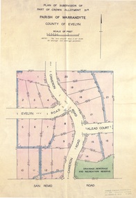
Document - Real Estate Folder, Savernake Estate, Ringwood, Victoria - Stage one - 1967
Plan of Subdivision, Part of Crown Allotment 31A and advertisement for sale of residential allotments with map showing layout of subdivision. Typewritten pricelist attached outlining suggested terms of sale as of 14 September, 1967.Subdivision includes Evelyn Road, Cameron Road, Klead Court, and San Remo Road. Agent - C.E. Carter & Son., 126 Whitehorse Road, Ringwood. (Phone) 87-6024, 87-6830, 870-2519, After hours: 723 3298, 878 2648. Subdivision Plan stamped Donald Cameron Consultants Pty. Ltd., Consulting Engineers, 472 Bourke Street Melbourne - 67-2602. -
 Bacchus Marsh & District Historical Society
Map, Bacchus Marsh Tuesday 23rd Oct. 1888, Lodge & Dunn's Paddocks 1888. Business and Mansion Sites
This map was created as a plan for an auction of land close to the Bacchus Marsh Railway Station. The auction took place on 23 October 1888. 102 allotments of land from an area known as Lodge and Dunn's paddocks was offered for sale. The auction was conducted by auctioneers based in Melbourne and was advertised in Melbourne newspapers as well as in the Bacchus Marsh Express newspaper. The auction plan contains a range of details including the selling agents, Munro and Baillieu; W.P. Lockhart; and John Turner, all of Melbourne, deposit terms for purchases, price of railway passes for a return trip from Melbourne to Bacchus Marsh of 1 shilling, and a description of the land as having 'magnificent views and perfect drainage'. A single page paper map showing allotments of land for sale along the Parwan Road in Maddingley. The map is pasted into a bound volume containing 76 maps or plans in total. High resolution digital image stored on BMDHS computer network. At bottom on left side: 'Harston & Co. Lith, Melb.'land sales bacchus marsh, land sales maddingley, bacchus marsh victoria maps, maddingley victoria maps -
 Federation University Historical Collection
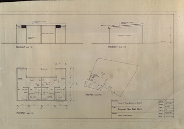
Plan, Ballarat School of Mines Proposed New Toilet Block, Barkly Street Campus, 1985, 16/08/1985
Plan showing plans for a toilet block at the former Ballarat East High School, Barkly Street.ballarat school of mines, barkly street campus, ballarat east secondary college, toilet block, architectural plans -
 Federation University Historical Collection
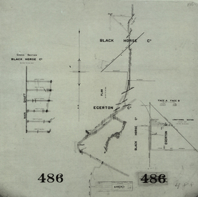
Plan, Black Horse Co
Plan showing a plan and cross section of the Black Horse Co. It also shows the Egerton Co, black horse co, cgt, mining, geological survey, cross section, egerton co -
Lakes Entrance Historical Society
Book, Doderlund Consulting Pty Ltd, Manuel for Cataloguers and Librarians using Wellington Shire History Database Standards, 2000
Guide to writing a disaster plan from preparedness to plan action during and after an actual disaster.reference material -
 Camberwell Historical Society
Document (Item) - Information sheet, Boroondara City of Harmony, Heritage Overlays
boroondara, camberwell, heritage -
 Bendigo Historical Society Inc.
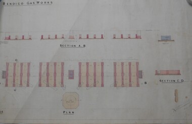
Map - BENDIGO WEEROONA GASWORKS MAP/PLAN COLLECTION: SECTION OF BENDIGO GASWORK, 1889
Plan: showing section of Bendigo Gasworks, Hand coloured plan. Dated December 18th. , 1889...? Thompson, Dec. 18th., 1889bendigo, gasworks, plan. -
University of Melbourne, Burnley Campus Archives
Plan, Plans for Garden Bed, c. 1980
(1) Coloured elevation plan of plants. (2) Plan with key for Plant Name, Size and Colour.plants, gardens, flower beds -
 Eltham District Historical Society Inc
Booklet - Folder, 2020 Vision: a preferred future, 1984
... planning ...Following council amalgamations, a series of community consultations were undertaken in 1995 to inform the development of a cohesive vision for the newly formed Shire of Nillumbik. A response to the new conditions which people of the Eltham/Diamond Creek/Greensborough and surrounding rural areas found themselves in as a result of the decision by the Victorian Government to amalgamate local governments into larger entities. The case for these reforms was strong, but the amalgamation process did disrupt some people's lives.The need to bring together the people within the new boundaries of Nillumbik was recognised by the Commissioners and the Chief Executive Officer of the Shire, who felt that a good way to begin was to develop a future vision for the Shire. It was decided that the people of the Shire should be asked what they wanted their future to be and a process of consultation was established through which people could express their views. Contents: Part One: Introduction, Nillumbik 1995 -what we thought, Nillumbik - thinking the future, Creatng a Nillumbik Community, Nillumbik's assets, Goals for Nillumbik 2020. Part Two: A sustainable society, population and density, the built environment, town and community centres, transport, agriculture, rural Nillumbik, Arts and cultural activity, the younger generation, Nillumbik's elders, planning for the disabled and health and well-being.40 pagesharry gilham collection, shire of nillumbik, vision, consultation, planning -
 Bendigo Military Museum
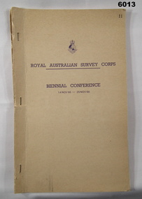
Administrative record - Report on Royal Australian Survey Corps Biennial Conference 14-25 Nov 1966, Army Survey Regiment, Nov 1966
Detailed Planning Report for the activities of the Royal Australian Survey Corps 1966-1968 as decided at the Corps Conference 14-25 Nov 1966Typed Report of decisions and plans for activities of the Royal Australian Survey Corps for 1996 -1998. Report includes names of attendees from all elements of the Survey Corps and their reports. paper report with light buff coloured card cover stapled along the left hand edge. 50 page report includes distribution list."Copy No 11" royal australian survey corps, rasvy, fortuna, army survey regiment, army svy regt, asr -
 Bendigo Historical Society Inc.
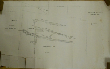
Document - MARKS COLLECTION: LANSELL'S 180 MINE PLAN
Plan on heavy parchment paper. Printed on bottom of plan 'Lansell's 180 plan' On top RH corner 'Victoria Quartz Mining Co' On LH side 'North Old Chum Co' Plan shows rock formation e.g. quartz lava slide. Plan found in documents from George Lansell auction, donated by Phillipa Marks.bendigo, mining, lansell's 180 mine -
 Bendigo Historical Society Inc.
Document - MARKS COLLECTION: SIDE ELEVATION AND GROUND PLAN OF STAIRWAY
Plan drawn on waxed paper. On top 'Side elevation' written in black ink, shows bottom treads of staircase, ornate bottom post of balustrade. On bottom of plan 'Ground Plan' written in black pen, 'Scale 1 Inch to a Foot' Plan contained in Fortuna Villa, George Lansell documents, although Fortuna Villa not written on plan.bendigo, house, fortuna villa -
 Kew Historical Society Inc
Plan - Subdivision Plan, Mont Victor Hill Estate, 1936
Pru Sanderson, in her groundbreaking ‘City of Kew Urban Conservation Study : Volume 2 - Development History’ (1988), summarised the periods of urban development and subdivisions of land in Kew. The periods that she identified included 1845-1880, 1880-1893, 1893-1921, 1921-1933, 1933-1943, and Post-War Development. These periods were selected as they represented periods of rapid growth or decline in urban development. An obvious starting point for Sanderson’s groupings involved population growth and the associated economic cycles. These cycles also highlighted urban expansion onto land that was predominantly rural, although in other cases it represented the decline and breakup of large estates. A number of the plans in the Kew Historical Society’s collection can also be found in other collections, such as those of the State Library of Victoria and the Boroondara Library Service. A number are however unique to the collection.Subdivision plans are historically important documents used as evidence of the growth of suburbs in Australia. They frequently provide information about when the land was sold on which a built structure was subsequently constructed as well as evidence relating to surveyors and real estate and financial agents. The numerous subdivision plans in the Kew Historical Society's collection represent working documents, ranging from the initial sketches made in planning a subdivision to printed plans on which auctioneers or agents listed the prices for which individual lots were sold. In a number of cases, the reverse of a subdivision plan in the collection includes a photograph of a house that was also for sale by the agent. These photographs provide significant heritage information relating house design and decoration, fencing and household gardens.A preliminary plan for the Mont Victor Hill subdivision of 1936 which included 23 allotments bordering the Rimington Nursery in Mont Victor Road. The subdivision created allotments in Victor Avenue, Heather Grove and Burke Road. Bisecting the Estate and clearly marked on the plan is the Railway Reserve which at this stage was all that remained of the Outer Circle Railway. The auctioneers note on the plan that the subdivision was made possible by the order of Messrs S. H. Bennet & H. Wright, the executors of the Wills of S. Bennett & E. Foreman.mont victor hill estate, subdivision plans - kew -
 Federation University Historical Collection
Plan - Plans, Ballarat School of Mines Brewery Building Plans, 1995, 1995
The Ballarat School of Mines Brewery Building is now a part of the Ballarat Technology Park.Site plan and landscape plan for Stage 3 works for the Ballarat School of Mines Brewery Building. .1) Site plan by Philip Cox Sanderson & Partners, Melbourne .2) Landscape plan by John Patrick Pty Ltd, Landscape consultants, Kew, Victoriaballarat school of mines, brewery building, ballarat technology park, john patrick, philip cox sanderson, landscaping, archtectural plans -
 Ringwood and District Historical Society
Document - Folder, Byways Estate Residential Subdivision, Ringwood East, Victoria 1965-1970
Collection of Subdivision brochures, plans, maps and sales information for sectional releases of Byways Estate.Subdivision plans include: First and second release (1965-66) - Alexandra Road, Isabel Avenue, Byways Drive and Buronga Avenue. Third release (1967) - Byways Drive, Buronga Avenue, Hender Street, Lester Avenue and Jess Court. Fourth and final release (1970) - Hume Street, Walhalla Drive and Hender Street. (Agent) C.E. Carter & Son R.E.S.I. 126 Whitehorse Road, Ringwood, 3134 (Telephone) 870 2519, 870 6830, 870 6024, A.H. 723 3298, 870 4604, 870 6454. Accompanying handwritten sales notes researched in 2024 by Richard Carter - Carter Real Estate - "Vendors - Jessie May Cleland & Alan Cleland of (what became) 4 Bywats Drive. Vendors retired to Buronga near Mildura. Rex was (I think) their son. Jess Court reflects vendor's name. See also History of Byways & Coolooli by Richard Carter in RDHS archives." (Vic Collections RDHS 18023 refers.) -
University of Melbourne, Burnley Campus Archives
Plan, 36 Railway Ave, Armadale, 1991-1997
Sets of plans for a Residential Garden produced by students for an assignment. (1) Tracing paper and paper copies site plan sketch. (2) Janine Bugg - Assessment Preliminary Plan, Concept Plan, Site Inventory and Analysis, Site Elevation A, Section Elevation B dated 26.05.1994. (3) Carmen Skrobonja - Assessment Main Plan & Section Elevation, Concept Plan dated 31.05.1991. (4) G. Mutimer - Preliminary Plan, Section Elevation, May 1994. (5) Melissa King - Assessment, Site Inventory & Analysis, Site Concept Plan, Preliminary Main Plan, Section Elevation, May 1997. (6) Jim Despotellis - Site Inventory & Analysis, Concept Plan, Preliminary landscape Design, 25.04.1994 - 15.05.1995. (Also see B11.0775.) (7) 33 Railway Ave (sic), Colour photographs pasted on paper. (8) Marli Draper - Site Inventory and Analysis, Concept Plan, Preliminary Plan, Perspective Feature Bed. (Also see B11.0773). (9) Cowan (Creations) - Site Inventory and Analysis, Concept Plan, Preliminary Plan, Assessment, 30.05.1994. (10) McRae (Designs) - Site Inventory and Analysis, Preliminary Main Plan, Concept Plan, Section View to Tussock Grass and Eucalyptus, 30.05.1997 - 01.06.1997. (11) Leah Syme - Site Inventory and Analysis.armadale, janine bugg, carmen skrobonja, melissa king, jim despotellis, marli draper, leah syme, g. mutimer, students, assignments -
 Flagstaff Hill Maritime Museum and Village
Drawing - Pastel Picture, W.R. Angus (Dr. William Roy Angus), 1925
This large pastel drawing was created by Dr W.R. Angus in 1925, the year after he graduated as a doctor in South Australia. In 1926 Dr Angus was appointed as Medical Assistant to Dr Thomas Francis Ryan, in Nhill, Victoria, where he extended his experiences in radiology and pharmacy. Eventually, in 1939, he and his wife Gladys moved to Warrnambool, Victoria, with their children. The drawing is part of the W.R. Angus Collection, which includes another of the doctor’s pastel drawings and a box of used pastels. The picture was framed by W.H. Rogers & Co. of North Terrace, Adelaide. The business also framed maps and plans. This pastel drawing is locally significant for being the work of Warrnambool doctor, W.R. Angus. It is part of the W.R. Angus Collection, which is significant for still being located at the site it is connected with, Doctor Angus being the last Port Medical Officer in Warrnambool. The collection of medical instruments and other equipment is culturally significant, being a historical example of medicine, administration, household equipment and clothing from late 19th to mid-20th century. Dr Angus assisted Dr Tom Ryan, a pioneer in the use of X-rays and in ocular surgery. The collection includes Army objects, which are examples of items issued to Doctors and Surgeons in the Medical Services of the Australian Army in World War 2. It also includes household items used by Dr Angus and his family from the 1920s in various locations including Warrnambool, together creating an understanding of the furnishing of an early to mid-20th century home.Pastel drawing behind glass in a rectangular wooden frame with an unusual oval wooden matt. The subject is a scene with a pink-tinted sky reflected in a river running between the foot of two hills with trees. The picture was created and signed by W R Angus in 1925. The back is covered in brown paper and has a mounting wire. Inscriptions are on the picture and the back. A remnant of the framer’s label is attached. The picture is part of the W.R. Angus Collection. Signature and date; “W.R.A. / 1925” Printed on label remnant; “—Rogers & Co. / - ORIA STREET / - way Station, North Terrace / “THE CORRECT FRAMERS” / -lise in Map and Plan Mounting / PHONE 5437”flagstaff hill, warrnambool, maritime village, maritime museum, shipwreck coast, great ocean road, drawing, pastel drawing, pastel drawing by w.r. angus 1925, rogers & co., w.h. rogers & co., correct framers, w.r. angus collection -
 Federation University Historical Collection
Plan, Ballarat School of Mines New Workshops, 17/11/1944
Hand drawn planballarat school of mines, new workshops, albert street -
 Greensborough Historical Society
Map, Greensborough Map with Rail Line Plan, 1970s
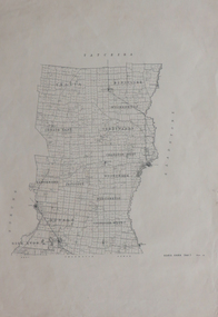
Central Greensborough area, including railway line and some landowners. Basic map made c. 1902; annotations dated to circa 1970sTwo copies of planParish of Keelbundora, County of Bourke. Central Greensborough areagreensborough, greensborough railway station -
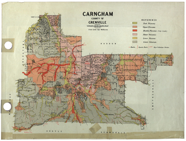 Federation University Historical Collection
Plan, Carngham, County of Grenville
A plan of Carngham, Victoria.snake valley, timber reserve, poverty point, recreation reserve, carngham, county of ripon, county of grenville, plan -
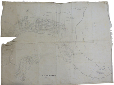 Federation University Historical Collection
Plan, Plan of Merimbula, 1932, 1932
Printed plan on cottonmerimbula, south pacific ocean -
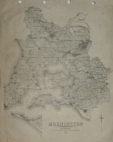 Federation University Historical Collection
Plan, Mornington, 1926, 1926
Printed plan on papermornington, phillip island, western port bay, bass straight, wonthaggi, lang lang, sherwood, nepean, narre worran, ringwood -
 Federation University Historical Collection
Plan, Kara Kara
Printed plan on paperkara kara, tatchera, gladstone -
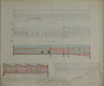
 Federation University Historical Collection
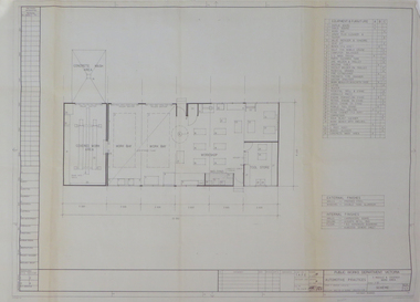
Plan, Ballarat School of Mines Practices Plan, 1981, 1981
Large building plan.ballarat school of mines, john t. green, automotive practices, trades, buildings, architectural plans -
 Federation University Historical Collection
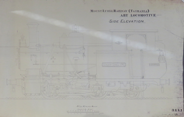
Plan, Mount Lyell Railway (Tasmania) ABT Locomotive Side Elevation, undated
On 29 March 1893 the Mount Lyell Mining and Railway Company was formed. This Tasmanian mining company was often referred to as Mount Lyell. Mount Lyell, and was the dominant copper mining company of the Tasmanian West Coast from 1893 to 1994, and was based in Queenstown, Tasmania. After consolidation of leases and company assets at the beginning of the twentieth century, Mount Lyell was the major company for the communities of Queenstown, Strahan and Gormanston. It closed in 1994. The Mount Lyell mining operations produced more than a million tonnes of copper, 750 tonnes of silver and 45 tonnes of gold since mining commenced in the early 1890s – which is equivalent to over 4 billion dollars worth of metal in 1995 terms.Copy of a plan of a locomotive.mount lyell, locomotive, mount lyell railway, quuenstown, tasmania, strahan, gormamston, railway