Showing 16825 items
matching snowy-river-bridge-1976
-
 Eltham District Historical Society Inc
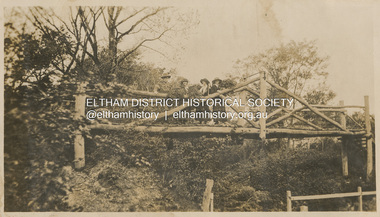
Photograph, "Curry, Byrne, McGeachy & self on rustic bridge, Eltham", 22 Oct 1919
The old Diamond Street bridge in Eltham had a raised section seen here and a lower section, the railings of which can just be seen. The upper pedestrian crossing provided continual access for foot traffic during times of flood. This photo is part of the Alice Broadhurst collection held by Yarra Plenty Regional Library, a series of 12 photo albums compiled by Alice Broadhurst (1896-1981), initially while working as a Voluntary Aid Detachment nurse with the Australian Red Cross at the Mont Park Military Hospital (No. 16 AGH) and subsequently as a nurse at the Royal Melbourne and Royal Women’s hospitals alongside many pioneering doctors of their fields. This photo depicts an outing with fellow VAD nurses McGeachy and Byrne and two patients of Mont Park, Curry and Caffery to Eltham in spring 1919 Digital file"Curry, Byrne, McGeachy & self on rustic bridge, Eltham, Oct 22, 1919"eltham, diamond creek, diamond street bridge, alice elizabeth broadhurst, byrne, caffery, curry, mcgeachy, nursing staff, mont park, 16 agh -
 Eltham District Historical Society Inc
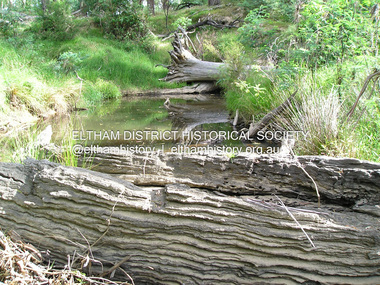
Photograph, Fay Bridge, Old timbers in the Diamond Creek at Hurstbridge, 27 February 2018
Just downstream from the bridgefay bridge collection, diamond creek (creek), hurstbridge, 2018-02-27 -
 Lakes Entrance Regional Historical Society (operating as Lakes Entrance History Centre & Museum)
Photograph, H D Bulmer, 1950 c
Proof on light cardBlack and white photograph of Bemm River Hotel taken on trip to Bemm River Victoriatopography, waterways -
 Wonga Park Community Cottage History Group
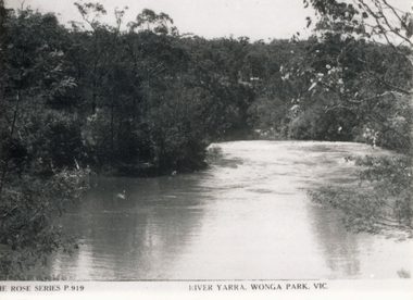
Photograph (sub-item) - Black and White, Viewing the camp from across the river at the 1948 Jamboree, Late 1940s
THE ROSE SERIES P. 919 RIVER YARRA, WONGA PARK -
 Camberwell RSL Sub-Branch
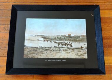
Photo, Australian Light Horse fording the Jordan River March 1918, 1918
Unique photo of the Australian Light Horse in the field in PalestineUnique actual photoPhoto in Wooden FrameAustralian Light Horse fording the Jordan River March 1918 -
Greensborough Historical Society
Newsletter, Greenhills and North Greensborough Progress Association, Community News: official journal of the Greenhills and Nth.Greensborough Progress Association and the Apollo Parkways Progress Association. 1st April, 1976. Edition No. 3/76, 01/04/1976
This edition includes a report on the The Apollo Parkways Progress Association's March 1976 meeting, Sporting complex for Diamond Valley, History in the district, 300 miles of park... the forestry concept, This and that, Functions of your local Health Department, School and Kinder news, Guide news, Battle of the bluestone, From the Council Chamber, Meet the natives, Diamond Valley Repertory, Apex Club in Greensborough. Newsletter, 28 p., illus.greenhills and north greensborough progress association, greenhills, apollo parkways progress association, apollo parkways -
 Eltham District Historical Society Inc
Photograph, Sketch of man on bridge over creek, 1971
Sketch of a man with a fishing pole standing on a bridge over a creek, stream or river in a bush setting. Unidentified artist and location.This photo forms part of a collection of photographs gathered by the Shire of Eltham for their centenary project book, "Pioneers and Painters: 100 years of the Shire of Eltham" by Alan Marshall (1971). The collection of over 500 images is held in partnership between Eltham District Historical Society and Yarra Plenty Regional Library (Eltham Library) and is now formally known as 'The Shire of Eltham Pioneers Photograph Collection.' It is significant in being the first community sourced collection representing the places and people of the Shire's first one hundred years.Digital imagesepp, shire of eltham pioneers photograph collection, fishing, creek, sketch, tranquil, unidentified, other areas, bush, outdoors, country life -
Port Melbourne Historical & Preservation Society
Pamphlet - Proposing West Gate Bridge, The Lower Yarra Bridge, 1968
Found in Lois Daley's father's technical manual''The Lower Yarra Bridge': brochure proposing West Gate Bridge, 1968engineering - bridges, west gate bridge, lower yarra crossing authority -
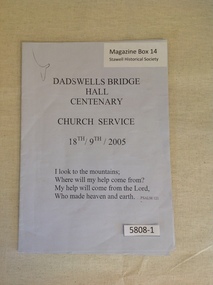 Stawell Historical Society Inc
Book, Dadswells Bridge Hall Centenary Church Service 18th/19th/2005, 2005
Order of service for the Dadswells Bridge Hall centenary, Church Service.Pale Blue/Grey Paper with black PrintDadswell Bridge Hall Centenary Church Service 18th - 19th 2005 I Look to the mountains; Where will my help come from? My Help will come from the Lord, Who made heaven and earth..... Psalm 121stawell religion -
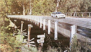 Stawell Historical Society Inc
Photograph, Delley's Bridge Halls Gap
White vehicle crossing Delley's Bridge Halls Gap c 2000. This Bridge has been replaced at Halls Gap with a new bridgetransport, bridge -
 Marysville & District Historical Society
Photograph (item) - Black and white photograph, Unknown
An early black and white photograph which shows a man and a woman standing on the bridge that crosses the Steavenson River at the base of the Steavenson Falls in Marysville in Victoria.An early black and white photograph which shows a man and a woman standing on the bridge that crosses the Steavenson River at the base of the Steavenson Falls in Marysville in Victoria. The Steavenson Falls are named after the Victorian Assistant Commissioner of Roads and Bridges, John Steavenson who arrived in Victoria in the early 1860s.steavenson river, steavenson falls, marysville, victoria, waterfalls, john steavenson -
Stawell Historical Society Inc
Photograph, Stawell High School Form 4 -- Named -- 1976
Stawell High School - 1976 ?stawell education -
 Federation University Historical Collection
Map - Geological, Tallangatta, New South Wales: 1:250,000 Geological Series, SJ 55-3, 1966, 1966
Compiled by the Geological Survey of N.S.W., Division of Regional Geology. Topographical base compiled from Snowy Mountains Hydro Electrical Authority, Department of Lands, County maps and Snowy Lease Map. Other sheet adjoin this map. There are 13 formation sections grouped into 9 - Quaternary, Tertiary, Middle Devonian, Lower to Middle Devonian, Lower Devonian, Upper Silurian, Silurian, Upper Ordovician and Ordovician.Large coloured map showing geological features, faults, bores, rivers and mineral deposits.Scale of map, longitude and latitude, river names. "Tallangatta 1:250,00" written in black pen.tallangatta, new south wales, geological survey, topographical base, snowy mountains hydro electrical authority, department of lands, snowy lease map, department of mines, quaternary, tertiary, middle devonian, lower to middle devonian, lower devonian, uper siluran, silurian, upper ordovician, ordovician -
![The Erskine River Waterfall / [by] Nicholas Caire, circa 1876](/media/collectors/550653872162f11fb04854aa/items/57831695d0cdd1176c4f24d8/item-media/57831701d0cdd1176c4f989a/item-fit-380x285.jpg) Kew Historical Society Inc
Kew Historical Society IncPhotograph, Anglo-Australasian Photographic Company, The Erskine River Waterfall, c. 1876
Nicholas Caire was born on Guernsey in the Channel Islands in 1837. He arrived in Adelaide with his parents in about 1860. In 1867, following photographic journeys in Gippsland, he opened a studio in Adelaide. From 1870 to 1876 he lived and worked in Talbot in Central Victoria. In 1876 he purchased T. F. Chuck's studios in the Royal Arcade Melbourne. In 1885, following the introduction of dry plate photography, he began a series of landscape series, which were commercially successful. As a photographer, he travelled extensively through Victoria, photographing places few of his contemporaries had previously seen. He died in 1918. Reference: Jack Cato, 'Caire, Nicholas John (1837–1918)', Australian Dictionary of Biography.An original, rare photograph from the series 'Views of Victoria: General Series' by the photographer, Nicholas Caire (1837-1918). The 60 photographs that comprise the series were issued c. 1876 and reinforced a neo-Romantic view of the Australian landscape to which a growing nationalist movement would respond. Nicholas Caire was active as a photographer in Australia from 1858 until his death in 1918. His vision of the Australian bush and pioneer life had a counterpart in the works of Henry Lawson and other nationalist poets, authors and painters.‘The Erskine River waterfall’ : Views of Victoria (General Series) No.52 : Albumen silver photograph | Photo on card with Title and Description on reverse | Mounted 24 x 30 cm; Photo 12 x 17 cm.On Reverse: ‘The River Erskine, which empties itself into Loutitt Bay, is noted for the grandeur of its scenery. Its sources, owing to the impenetrability of the bush and the mountainous nature of the country, are unknown. They may eventually be traced a long way into the Cape Otway Ranges. An idea of the difficulty with which the present very beautiful illustration was obtained may be gained from the fact that it took our assistants, several days to convey the apparatus a distance of six miles and back. The depth of the fall is 150 feet. The foliage as seen comprises the very rare staghorn tree, the myrtle, the dogwood tree, and ferns.’nicholas caire (1837-1918), lorne (vic), erskine river (vic), landscape photography -
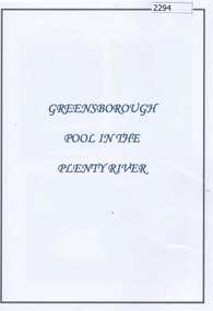 Greensborough Historical Society
Folder (article and photographs), Greensborough Pool in the Plenty River / compiled by Marilyn Smith, 1937o
Society member Marilyn Smith has compiled a collection of historic articles from local newspapers, historic and modern photographs of the swimming pool in the Plenty River Greensborough, opened in 1937. The Pool is still visible from the Main Street bridge and present day photographs are also included. A short story by Gary Partington tells of his memories of the Plenty River as he was growing up.An historical view of the Greensborough pool in the Plenty River.Folder with pink plastic cover. 12 pages of text and photographs.plenty river, greensborough swimming pool, marilyn smith, gary partington -
 Greensborough Historical Society
Photograph - Photograph - Digital Image, Main Street bridge Greensborough 1970s, 1970s
A colour photograph of the corner of Para Road and Main Street Greensborough in the 1970s, during the duplication and construction of the bridge over the Plenty River.Digital copy of colour photograph.main street greensborough, para road greensborough, plenty river bridge -
Glenelg Shire Council Cultural Collection
Photograph - Photograph - Casterton, Victoria, c. 1963
SOURCED FROM CASTERTON TOWN HALL (FORMER SHIRE OF GLENELG)Black and white photo of Glenelg River Bridge at CastertonBack: 'Glenelg River Bridg at Casterton' handwritten, blue biro. Blue line, arrowed each end, drawn across photo, 3" written above line. Black number stamp.glenelg river, casterton, tourism -
Vision Australia
Text, Newspaper clippings 7 (1969-1970, 1974-1976), 1969-1970, 1974-1976
To keep current with media articles on how vision impaired people, blindness organisations and their activities were reported in the press, books of newspaper cuttings were created. News stories were taken from local, regional and national papers covering a variety subjects. Three loose pages containing articles from 1969-70 are included at the front, whilst at the back are loose 1976 clippings that have not been pasted in.1 brown covered folder with newspaper cuttingsPress clippinsassociation for the blind -
 Marysville & District Historical Society
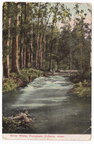
Postcard (item) - Colour postcard, Nicholas John Caire, River Watts, Fernshaw, Victoria, Austr, 1858-1918
One of a series of postcards of photographs taken by socialite photographer Nicholas John Caire. N.J. Caire had a great love for the area and in the late 1800's took many photographs of Marysville and its surrounds.One of a series of postcards of photographs taken by socialite photographer Nicholas John Caire. N.J. Caire had a great love for the area in and surrounding Marysville and in the late 1800's took many photographs of Marysville and its surrounds. N.J. Caire was born in 1837 in Guernsey. He arrived in Adelaide about 1860 along with his parents who encouraged his early interest in photography. He opened a studio in Adelaide in 1867 after traveling extensively throughout the Gippsland taking photographs. After marrying in 1870 he moved to Talbot in Victoria until 1876 when he opened a studio in the Royal Arcade in Melbourne. After 1885 N.J. Caire gave up his city work and made his home in South Yarra and devoted the rest of his life to outdoor photography, specializing in the bush, the gullies and the mountains of south-eastern Victoria. POST CARD This Space may be used for Correspondence. The Address only to be written he (rest obscured by postage stamp) Date stamp / MAR 4 Orange postage stamp with portrait depicting Queen Victoria 95686 To Bessie/ Hope you are enjoying yourself/ I see there was some excitement/ at the Marysville Races/ Kind regards and/ best wishes/ & love from all of/ us at 384/ Punt Road/ & William Miss Bessie Taylor/ The Chestnuts/ Marysville Vicmarysville, victoria, nicholas john caire, watts river, fernshaw, 95686, postcard, souvenir -
 Marysville & District Historical Society
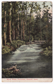
Postcard (item) - Colour postcard, Nicholas John Caire, River Watts, Fernshaw, Victoria, Austr, 1858-1918
One of a series of postcards of photographs taken by socialite photographer Nicholas John Caire. N.J. Caire had a great love for the area and in the late 1800's took many photographs of Marysville and its surrounds.One of a series of postcards of photographs taken by socialite photographer Nicholas John Caire. N.J. Caire had a great love for the area in and surrounding Marysville and in the late 1800's took many photographs of Marysville and its surrounds. N.J. Caire was born in 1837 in Guernsey. He arrived in Adelaide about 1860 along with his parents who encouraged his early interest in photography. He opened a studio in Adelaide in 1867 after traveling extensively throughout the Gippsland taking photographs. After marrying in 1870 he moved to Talbot in Victoria until 1876 when he opened a studio in the Royal Arcade in Melbourne. After 1885 N.J. Caire gave up his city work and made his home in South Yarra and devoted the rest of his life to outdoor photography, specializing in the bush, the gullies and the mountains of south-eastern Victoria. POST CARD This Space may be used for Correspondence. The Address only to be written here. Stamp-VICTORIA Date stamp / 2 NOV Orange postage stamp/ value one penny/ depicts portrait of Queen Victoria 95686 Miss L. Smith/ Oxford Place/ Mount Stree / Nechells/ B'ham/ Englandmarysville, victoria, nicholas john caire, watts river, fernshaw, 95686, souvenir, postcard -
 Flagstaff Hill Maritime Museum and Village
Document - Navigation Chart, Approaches to Perak River
British Admiralty Navigation Chart - Malacca Straits - Approaches to Perak Riverwarrnambool, shipwrecked-coast, flagstaff-hill, flagstaff-hill-maritime-museum, maritime-museum, shipwreck-coast, flagstaff-hill-maritime-village, shipwrecked-artefact, navigation chart, british admiralty navigation chart, approaches to perak river, malacca straits -
 Phillip Island and District Historical Society Inc.
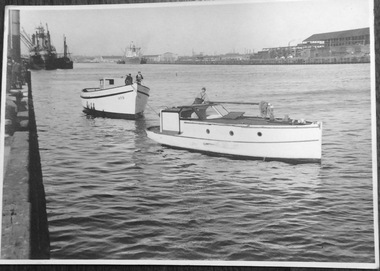
Photograph, Fishing boat, Penguin, launch on the Yarra River, 1940s
Matte black and white photo of the Penguin being towed on the Yarra RiverNillegg family, fishing boat- penguin, fishing boats -
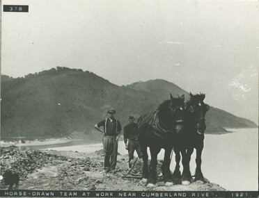 Lorne Historical Society
Photograph, Horse drawn team at work near Cumberland River 1921
Horsedrawn team of two Clydesdale horses and workmen at Cumberland River 1921g.o.r. clydesdale horse team cumberland river 1921 -
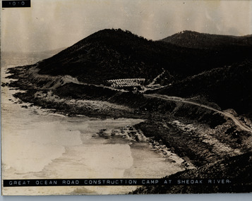 Lorne Historical Society
Photograph, Camp at She Oak River 1930's. G.O.R
Photograph of workers camp at She Oak River circa 1930's she oak river camp site: workers' campsite, sheoak river, workers camp -
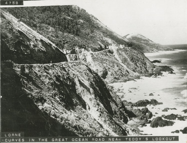 Lorne Historical Society
Photograph, Photograph West of Cumberland River on the Great Ocean Road
Photo showing the curves on the Great Ocean Road west of the Cumberland River/great ocean road: west of cumberland river; -
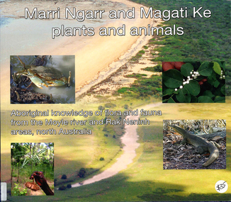 Victorian Aboriginal Corporation for Languages
Book, Ngarul Jimmy Nambatu et al, Marri Ngarr and Magati Ke plants and animals : Aboriginal knowledge of flora and fauna from the Moyle River and Neninh areas, North Australia, 2009
Aboriginal knowledge of flora and fauna from the Moyle River and Neninh areas.Maps, b&w illustrations, b&w photographs, colour photographs,marri ngarr, magati ke, wadeye, moyle river, northern territory, flora, fauna, ethnobiology -
 Wangaratta Art Gallery
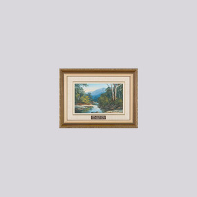
Painting, Mary Watson, The Buckland River, 1988
Rural City of Wangaratta Collection. Gift of the Wangaratta Y's Men's Club.A river landscape painted with oils in shades of green, blue, brown, and grey.Obverse: MARY WATSON/ (bottom right corner) WINNER - PAIR SMALL PAINTINGS/ 1988 WANGARATTA ART SHOW/ Presented By WANGARATTA Y'S MEN'S CLUB/ (plaque mounted on frame)wangaratta art gallery, mary watson, painting, landscape, buckland river -
 Wangaratta Art Gallery
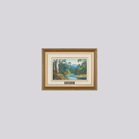
Painting, Mary Watson, The Ovens River, 1988
Rural City of Wangaratta Collection. Gift of the Wangaratta Y's Men's Club.A river landscape painted with oils in shades of green, blue, brown, and grey.Obverse: MARY WATSON/ (bottom right corner) WINNER - PAIR SMALL PAINTINGS/ 1988 WANGARATTA ART SHOW/ Presented By WANGARATTA Y'S MEN'S CLUB/ (plaque mounted on frame)wangaratta art gallery, mary watson, landscape, painting, ovens river -
 Ballarat Heritage Services
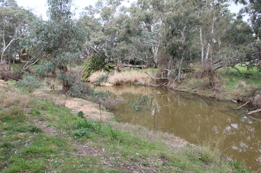
Photograph - Photograph - Colour, L.J. Gervasoni, River at Avoca, 2011, 06/08/2011
Colour photograph of a pre-olympic swimming pool in the river at Avoca, Victoria.avoca, pre-olympic swimming pool, avoca sswimming pool -
 Ballarat Heritage Services
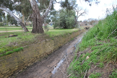
Photograph - Colour, L.J. Gervasoni, Channel near the Avoca River, Avoca, 2011, 06/08/2011
Colour photograph of a stone water channel near the Avoca River in Avoca. avoca, bridge, avoca river, channel, stone, drystone