Showing 123771 items matching "main-road"
-
 University of Melbourne, Burnley Campus Archives
Photograph - Black and white print, 76/7, 1947
"The roads have been constructed." THKroads, e. m. gibson collection -
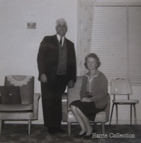 Melton City Libraries
Photograph, Tom and May Barrie, c.1960s
Tom and May at Ferris Road, Meltonlocal identities, council -
Canterbury History Group
Ephemera - Enjoy a refreshing and relaxing shopping experiece
Flyer advertising Maling Road shopscanterbury, canterbury post office, maling road, shops, tim's bookshop, cafe woodstock, kelvin of canterbury -
 Whitehorse Historical Society Inc.
Photograph - Coloured Photo x 5, Commercial scenes of Whitehorse
Home HQ in Whitehorse Road Nunawadingnunawading, brandsmart, whitehorse road -
 Mt Dandenong & District Historical Society Inc.
Photograph, George Barber's Home Forest Edge after 1912 Looking South West, c1912
George Barber built a homestead later named Forest Edge on Barber's Road and lived there with his wife Sarah Ann (nee Richardson).Black and white photograph showing the side view of a house and three outbuildings. Reverse of photograph has handwritten description by John Lundy-Clarke.George Barber's home on bend of Barber's Road on Lot 25, Village Settlement. Showing passionfruit plantation. Buggy shed top right. Hay shed lower right. Stables, cart shed and men's quarters lower left about 1912. Photo copied by JLC in 1973.forest edge, george barber, sarah ann barber, kalorama, barber's road -
 Melbourne Tram Museum
Photograph - Black and White photograph, 11/01/1925 12:00:00 AM
Black and white photograph of MMTB B class No. 23 taken from a front verandah on its first trip at the corner of High St and Woodlands Ave 11-1-25 on the return trip from Burke Road to Kew Depot. A young lady is standing by the front fence. The tram is well loaded with passengers and possibly the conductor standing in the rear section of the tram, revelling at speed.On rear in ink "MMTB No. 23 taken from a front verandah on its first trip at the corner of High St and Woodlands Ave 11-1-25 on the return trip from Burke Road to Kew Depot."trams, tramways, high st kew, b class, opening, tram 23, mmtb -
 Bendigo Military Museum
Letter - LETTER WW1, C.1916?
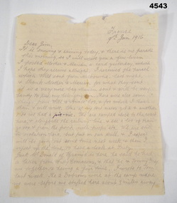
The letter is from Alfred G Ferris No 2156 AIF, dated 9.1.1916, it is doubtful if this is correct as he enlisted on 14.3.1916 and embarked for England on 1.8.1916. Refer Cat No 4183.3P for Alf’s his service details.Letter, rectangular shape, off white colour, ruled lines, double sided, dated.Main points, “France 9th Jan 1916”, “Dear Jim, from your affectionate brother Alf”letters, france, ww1 -
Glenelg Shire Council Cultural Collection
Photograph - Photograph - Spray Wall Extensions to Main Breakwater, August 1980, 1980
Port of Portland Authority archivesFront: (no inscriptions) Back: Spray Wall Extensions/ To Main Breakwater/ Aug - 1980 (pencil, lower right)port of portland archives -
Ringwood and District Historical Society
Legal record - Fire Insurance document (C.E.Carter), Fire Insurance - Atlas Assurance Co Ltd for J. E. M. Williams, 1934
Standard form of Fire Insurance Policy issued by Atlas Assurance Company Limited, England.Policy issued to J. E. M. Williams for property in Main Street Ringwood, dated September 1934. -
 Rutherglen Historical Society
Photograph - Image, 1925-1935 (Approximate)
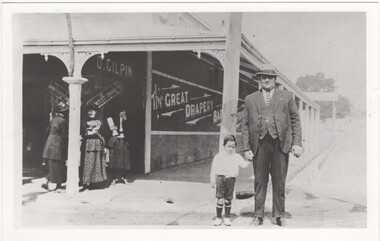
Donated by Mrs Lockwood, Bonnie, formerly HamiltonPostcard size, black & white reproduction, unframed. Norman Hamilton & small boy in front of O. Gilpin's store which once belonged to his father Mr David Hamilton"Norman Glen Hamilton, cnr High & Main Streets O. Gilpin store ex D.G. Hamilton"norman hamilton, gilpin store, d g hamilton -
Moorabbin Air Museum
Document (Item) - Bell Helicopter Company Customer Service Model 47 Maintenance Clinic
Presentation Of Recommended Techniques, Vibrations ,Clutch Operation , Preventative Maintenance , Main Rotor Metal Blade Corrosion -
 Bendigo Historical Society Inc.
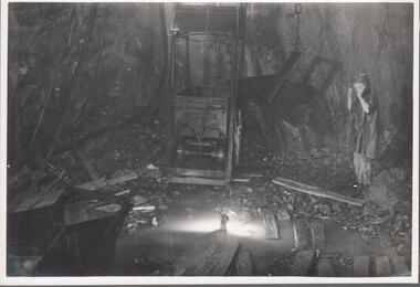
Photograph - Napoleon Main Shaft, 1935
Significant to mining history of Bendigo.Black and white photograph: metal mine cage at level in Napoleon mine. Man standing on right hand side looking directly at cage, with both arms raised. Lengths of timber and rock rubble on floor of level. Written in pencil on back of photograph : 'Nap. main shaft 22/6/36 opposite No. 10 plat' napoleon gold mine, mine machinery, plat, shaft -
 Melbourne Tram Museum
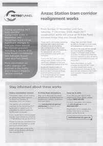
Pamphlet - Metro Tunnel - Anzac Station tram corridor works, Rail Projects Victoria, 11/2022
Provides information about the works planned to realign tram tracks at the Metro Tunnel Anzac station, following the completion of the surface works. Gives timing, tram routes affected, plans of the proposals, contact details. All St Kilda Road routes would be affected from 27/11/2022 to 17/12/2022, tram stops would be closed, bus replacement services. includes works to remove the Glenhuntly Road level crossing at Glenhuntly Station. Yields information about the trackworks for the future Anzac Station interchange and St Kilda Road services.Set of two documents issued by Rail Projects Victoria (Metro Tunnel) and Yarra Trams with regard to the reallignment of tram tracks at Anzac Station Nov. 2022 1 - Metro Tunnel - Works proposed, maps - 6 A4 pages 2 - Yarra Trams - Service Changes St Kilda Road works - 4 A4 pages.anzac station, metro tunnel, tramways, st kilda road, domain road, domain interchange, park street, track work, tram tracks, glenhuntly road, glenhuntly station, level crossings -
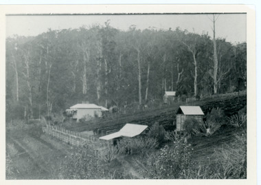
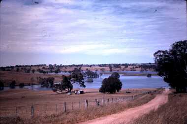 Bendigo Historical Society Inc.
Slide - DAVID MCDONALD COLLECTION: EPPALOCK. CONSTRUCTION, c1962
Eppalock. Construction. The lake is now filling, the fence line and the road disappear down into the lake. Near the water there is a ''Road Closed sign''. To the left of the road there are two old sheds. Markings: Eppalock Dam, Dec 1962 near Lyal.Kodakcivil engineering, water supply, eppalock -
Whitehorse Historical Society Inc.
Pamphlet - Advertising brochure, Kenmare Heights Estate, 1927
Clearing sale by public auction , Saturday 26/11/1927 of Kenmare Heights Estate Mont Albert, Situated between Belmore Road, Boundary Road, Strabane Avenue, Union Road and Dunloe Avenue. Advertising material and mapknight & harwood auctioneer, auctions, kenmare height estate, union road mont albert, belmore road, relowe crescent, whitehorse road, evalina street, francesca street, mozelle street, dunloe avenue -
Canterbury History Group
Photograph - View looking through the lane way between No. 114 and No. 112 Maling Road towards the Post Office, Jan Pigot, 27/03/1993 12:00:00 AM
Coloured photograph of a view looking towards Maling Road and the Post Office from the red brick lane way that runs between No. 114 and No. 112 Maling Road. This is taken from the car park behind the Maling Road shops.canterbury, maling road, shops, brickwork, laneways -
Whitehorse Historical Society Inc.
Article, Attack on 'emotional blackmail', 1994
Emotive claims that Box Hill faced a takeover by Nunawading if the City of Whitehorse did not go ahead have outraged Nunawading Mayor, Kevin Abbott.Emotive claims that Box Hill faced a takeover by Nunawading if the City of Whitehorse did not go ahead have outraged Nunawading Mayor, Kevin Abbott. Cr Abbott said Box Hill was publicly distancing itself from Nunawading yet privately it has considered extending its boundary to divide Nunawading at Blackburn Road.Emotive claims that Box Hill faced a takeover by Nunawading if the City of Whitehorse did not go ahead have outraged Nunawading Mayor, Kevin Abbott. local government, city of nunawading, city of box hill, abbott, kevin, amalgamations -
 Eltham District Historical Society Inc
Photograph - Aerial Photograph, Landata, Eltham, Vic, Apr. 1963
Centred on present day Griffith Park Road, Eltham bounded by Mount Pleasant Road to north, Yarra River and Templestowe to south, Main Road at Reynolds Road to east and Falkiner Street to west. Historic Aerial Imagery Source: Landata.vic.gov.au Aerial Photo Details: Project No :486 Project : MELBOURNE (1963) PROJECT Run : 7 Frame : 233 Date : 04/1963 Film Type : B/W Camera : RC8 Flying Height : 5100 Scale : 9600 Film Number : 1805 GDA2020 : 37°44'04"S, 145°09'10"E MGA2020 : 337237, 5822053 (55) Melways : 22 A10 (ed. 42)aerial photo, neil webster collection, 1963-04, eltham, falkiner street, griffith park road, melway 22a10, mount pleasant road, reynolds road, templestowe, yarra river -
 Lakes Entrance Historical Society
Photograph - paintings by Marie Fish, M Fish, 1990c
paintings by Marie Fish of the home of Beveridge family of KiaOra Guest House before it was relocated from Esplanade to 128 Golflinks Road Lakes Entrance Victoria. Also a painting by Marie Fish number 04083.2 size 8 x 10.5 cmColour photograph of paintings by Marie Fish of the home of Beveridge family of KiaOra Guest House before it was relocated from Esplanade to 128 Golflinks Road Lakes Entrance Victoria. Also another painting by Marie Fish number 04083.2 size 8 x 10.5 cmarts, exhibition, people -
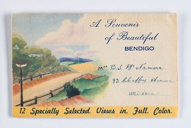 City of Greater Bendigo - Civic Collection
Souvenir, Nucolorvue Productions, A Souvenir of Beautiful Bendigo, c. 1940
As tourism and touring grew in the early and mid 20th century, sending letters and postcards was one of the main forms of communications friends and family would use to share their travels and remind loved ones that they were thinking of them while away. Bendigo's geographic location in central Victoria and relatively closeness to Melbourne has meant that capturing the tourist dollar has been an important focus for promotional activities of the City. Businesses such as Nucolorvue Productions serviced the need for high quality printed souvenirs such as these.Mass produced souvenir foldout 'views' of Bendigo packaged in an envelope. Inside contains six double sided postcard sized, hand tinted photographs highlighting local popular sites. Includes text describing Bendigo's geographic location and main industries and attractions. Envelope is addressed. Nucolorvue Productions produced this style of souvenir with a generic country scene on the envelope and site specific information and images inside for such places as Adelaide Hills, Murray Valley, Shepparton and Warrnambool.Front; A Souvenir / of Beautiful / BENDIGO / 12 Specially Selected Views in Full Colour /Mrs B. S. Mc Namara / 93 Chaffey Avenue / Mildura. Verso; Have a look of (sic) Bendigo / Love / From / Your Loving / Son in Law Bill / Published by Nucolorvue Productions. Elwood. Victoriacity of greater bendigo tourism -
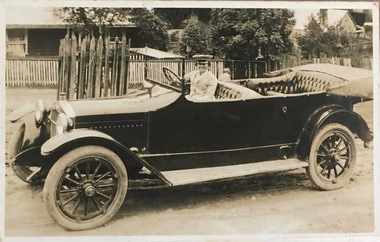 Kew Historical Society Inc
Photograph, Alice Anderson in her Hupmobile, c.1917
Alice Anderson was Australia’s first female garage proprietor when she opened her all-female business in Cotham Road (Kew, Victoria) in 1917. An authentic, rare original photograph of Miss Alice AndersonOriginal 'snap' of the Kew identity Alice Anderson in her touring car.Inscribed on mount: "Alice Anderson in her Humba - perhaps 1916. She took passengers between Melbourne and Narbethong. KH-40." Inscribed on reverse: "Sports Torquay 1917." and "1918 Miss Alice Anderson The Kew Garage ** Cotham Road. Car hire and service to motors." alice anderson, motor mechanics - kew (vic), motor mechanics - women -
 Whitehorse Historical Society Inc.
Document - Notes from Trove, Sampson Murder, Jan 1928, 1928
Notes from the State Library's Trove collection on the murder of Iolene Sampson 28 years old on 3 Jan 1928 at quarry Road Mitcham and the subsequent court case on 22 Feb 1928.Iolene Sampson had been married to Ted Sampson for 15 months and they were orchardists near the corner of Quarry and Mitcham Roads. The Kleinert's had an orchard across the lane from them. Ernest Ambrose Kleinert, 20 years old, was tried for the murder of Iolene Simpson but was acquitted. The murder was never solved.kleinert ernest ambrose, , sampson mary iolene, sampson edward augustus -
Clunes Museum
Newspaper - NEWSPAPER CUTTING, Nov 1980
THIS NEWSPAPER/CUTTING FROM NOV. 1980 WAS COLLECTED BY THE LATE MRS. LENA WATTLEWORTH. IT IS BELIEVED TO SHOW THE FIRST HOUSE BUILD ALONG THE CRESWICK ROAD, WHICH WAS BUILD BY MISS BREDA TREMBATH'S GRANDFATHER MR GEORGE PERRY.NEWSPAPER CUTTING OF GEORGE PERRY'S GENERAL PRODUCE STORE AND RESIDENCE. November 1980. Citizen Award winner Brenda Trembath of Clunes has kindly allowed us to use this photograph of what is believed to be the first house built along the Creswick Road. It was built by Brenda's grandfather, George Perry.local history, document, newspaper cutting, trembath, perry -
 Rutherglen Historical Society
Photograph - Image, 1970s
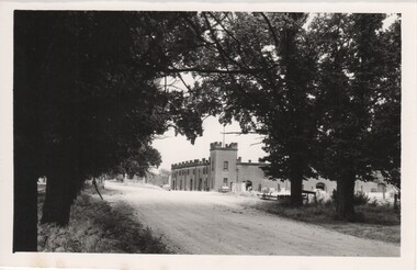
All Saints Estate is a family owned winery established in 1864 and located on the banks of the Murray River in Wahgunyah, North East Victoria. Original owners George Sutherland Smith, and John Banks, arrived from Caithness, Scotland in 1852. They were just 23 and 20 years of age. Choosing to settle in the Wahgunyah area, they used their training as engineers from the Edinburgh Railway Institute to build a bridge over the Edwards River at Deniliquin. They were also involved in the construction of several buildings in Beechworth including the Presbyterian Church, part of the Gaol and the original hospital of which the granite facade still remains today. Smith and Banks began growing vines at ‘Sunday Creek’ closer to Wahgunyah than the present All Saints Estate winery, before relocating to build the 'All Saints castle' just three miles north of Wahgunyah, in 1864. The partners took up 100 acres and proceeded with planting vines in earnest whilst also constructing pise cellars made from the estate soil. The All Saints Estate castle was based on the design of ‘The Castle of Mey’, including turrets and a tower. The castle was constructed mainly of handmade bricks that were fired in the All Saints Estate Brick Kiln (classified on the Victorian Heritage Register) on the property. However, only the battement parapets of the lower wall and a turrets were copied, not the main castle style. The Castle of Mey, most recently owned by the late Queen Mother, was where George Sutherland-Smiths’ father was a carpenter and joiner.Black and white photograph showing a view, up a road between the Elm Tree entry drive of All Saints Winery wineries, north east victoria, wine industry, all saints winery, rutherglen, wahgunyah, winemaking, castle, winery -
 Rutherglen Historical Society
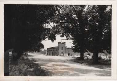
Image, 1970s
All Saints Estate is a family owned winery established in 1864 and located on the banks of the Murray River in Wahgunyah, North East Victoria. Original owners George Sutherland Smith, and John Banks, arrived from Caithness, Scotland in 1852. They were just 23 and 20 years of age. Choosing to settle in the Wahgunyah area, they used their training as engineers from the Edinburgh Railway Institute to build a bridge over the Edwards River at Deniliquin. They were also involved in the construction of several buildings in Beechworth including the Presbyterian Church, part of the Gaol and the original hospital of which the granite facade still remains today. Smith and Banks began growing vines at ‘Sunday Creek’ closer to Wahgunyah than the present All Saints Estate winery, before relocating to build the 'All Saints castle' just three miles north of Wahgunyah, in 1864. The partners took up 100 acres and proceeded with planting vines in earnest whilst also constructing pise cellars made from the estate soil. The All Saints Estate castle was based on the design of ‘The Castle of Mey’, including turrets and a tower. The castle was constructed mainly of handmade bricks that were fired in the All Saints Estate Brick Kiln (classified on the Victorian Heritage Register) on the property. However, only the battement parapets of the lower wall and a turrets were copied, not the main castle style. The Castle of Mey, most recently owned by the late Queen Mother, was where George Sutherland-Smiths’ father was a carpenter and joiner.Black and white photograph showing a view, up a road between the Elm Tree entry drive of All Saints Winery On back of photo: "250% [upper case D in small circle] All Saints"wineries, north east victoria, wine industry, all saints winery, rutherglen, wahgunyah, winemaking, castle, winery -
 Whitehorse Historical Society Inc.
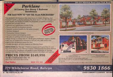
Newspaper - Advertisement, Parklane, 1/05/1997
Cutting of advertisement for Parklane '16 luxury two storey, 3 bedroom townhouses' at 205 Mitcham Road, (near Park Road). Agent Paul walker. Colour drawing. Also photographs of Canterbury Terrace, 910 Canterbury Road, Box Hill and Mitcham Gardens, Doncaster East Road, Mitcham. In Nunawading Gazette, 28th May, 1997parklane;, mitcham road, mitcham, residential development -
 Surrey Hills Historical Society Collection
Photograph, Streetscape near the corner of Victoria Crescent and Hotham Street, Surrey Hills
Prior to subdivision for housing this area was paddocks used for grazing of cattle and used as part of the course in the early days of the Surrey Hills Golf Club. Reproduced by permission of Mr John Arnold from his book: "The Riversdale Golf Club - a history, 1892-1977." Copyright to book: Riversdale Golf Club. Surrey Hills Golf Club operated from 1892-1908 then moved and became Riversdale Golf Club. The game was played across paddocks from Trafalgar Street, Mont Albert to Whitehorse Road and down Victoria Crescent to where Box Hill TAFE is now located in Elgar Road. There were problems with cows eating the tee flags! The clubhouse still exists as 30 Trafalgar Street.Black and white photo taken from the centre of a bitumen road which is flanked by bluestone guttering. Nature strips, drive cross-overs and house fences are shown. Trees on the RHS nature strip are pollarded to avoid overhead power and telephone lines. There houses in the background."Bottom: The same view today taken from the intersection of Victoria Crescent and Hotham Street, Surrey Hills."surrey hills golf club, hotham street, victoria crescent, riversdale golf club, surrey hills, john arnold -
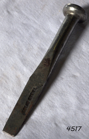 Flagstaff Hill Maritime Museum and Village
Tool - Caulking Tool, Ward & Payne Ltd, Late 19th century
Caulking is the traditional technique used on wooden vessels built with butted or clinker-built planks to fill the gaps between these planks while still allowing the wood to flex and move. This involved driving the irons, hammered in with the mallet, deep into the seams to open them up. After this, spun yarn, oakum (hemp) or cotton was driven deep into the gaps. The hemp or cotton was soaked in creosote or pine tar to make the joins watertight. Caulking also played a structural role in tightening up the hull or deck by reducing the longitudinal movement of the neighbouring planks. The subject item was made by Ward & Payne of the Limbrick Works at Hillsborough, Sheffield England manufacturers of hand-forged tools. Their trademark registered in 1850 was a Letter "W" & "P" stamped into the steel. The firm was established by David Ward (1767-1822) in 1803 the company became David Ward & Sons, in 1837 after Ward's son Edward joined the firm. In 1845 Henry Payne the founder's son-in-law became a partner but died in 1850 after which the company reverted to the Ward family. The business then concentrated on making carving tools, chisels and gouges. In 1882 David Ward's grandson David Ward Jr. (1835-1889) purchased land and built a factory at Sheffield North known as the "Limerick Wheel". For a time Wards operated from both 106-114 West Street Sheffield and at Limbrick Road, Hillsborough on the river Loxley. By 1911 they had expanded into making spades, forks, sheep shears and many other types of edged tools including drills and wood planes. In 1967 Wilkinson Sword purchased all the company's share capital and continued to sell Ward & Payne tools until 1970 when a fire burned the factory down and housing development was built on the site. The subject item is significant as it gives a snapshot of the technological development of sailing ships and their operation before steam-powered vessels took over around the world. Tools such as the subject item demonstrate the traditional craftsmanship and skill of the shipwright and the aesthetic quality of the timber ships designs of the time. Caulking tool with square end"WARD Sheffield"flagstaff hill, warrnambool, flagstaff hill maritime museum, shipwreck coast, flagstaff hill maritime village, james s steele, caulking iron, caulking tool, shipwright tools, ward & payne sheffield, forged tools -
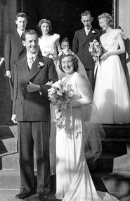 Surrey Hills Historical Society Collection
Work on paper - Photograph, Margaret Black's wedding 1st May 1948, 1948
Margaret Johnson was born and raised in the country. She came to Melbourne to attend secondary school at age eleven. She stayed with the family of her uncle, Dr Carrington, in their home / surgery still located at 174 Union Road, the Surrey Hills Medical Centre. Later, whilst waiting to commence her kindergarten training course, she met Jessie Black and they became firm friends and it was through Jessie that Margaret met Jessie’s brother and her future husband, Thorby Black. The Black family had been residents of Mont Albert for many years and Thorby was in the air force at the time. Margaret and Thorby were married at St Stephens Presbyterian Church in Surrey Hills on 1 May 1948. Her wedding dress was bought at Canns on the corner of Elizabeth Street & Flinders Lane. It was one in an exhibition held as part of a Surrey Hills Festival in the early 2000's. Like others in the exhibition, it no longer had its train and the sleeves have been shortened. Margaret recalled that after her wedding she wore it as an evening dress. Her bridesmaids’ dresses were a little unusual for the time, as they too were white and their flowers were subdued pink and blue. According to Margaret, the popular fashion was for brightly coloured dresses and bright flowers for the bridesmaids. The positioning of the garlands of flowers in their hair was also unusual. They were placed at the back so that the congregation could see them during the ceremony. Housing was in very short supply in the years following the war, so after they were married, Margaret and Thorby moved into a small flat created at Dr Carrington’s surgery. They later moved to a house built in 1926 in Black Street, Mont Albert, which continued to be Margaret’s home until her death. weddings, mrs margaret black, miss margaret johnson, mr thorby black, st stephens presbyterian church, bridal wear -
 Warrnambool and District Historical Society Inc.
Household, Vase, Early 20th century
This vase would have been used to hold five small flowers or fronds and would have been a decorative item on a dining table or mantelpiece. Today a vase holding one or a small number of flowers is called a specimen vase and the style of these tends to be less decorative than the item described here. This item has no known local provenance but is retained as an example of a household item from the past.This is a white china vase with a central pillar representing the trunk of a tree and (originally) four pillars branching out from the main pillar to represent the branches of a tree. One of these pillars is now missing. The china stems holding the branch columns have embossed flowers and fronds. The main pillar and the branch pillars have irregular-shaped openings for flower insertion.household items, history of warrnambool