Showing 123819 items matching "main-road"
-
 Whitehorse Historical Society Inc.
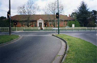
Photograph, Mitcham Primary School, 1/10/2000 12:00:00 AM
Coloured photograph of Mitcham Primary School, Mitcham Road, Mitcham taken from traffic lights on Doncaster East Road. Fence erected 2000.mitcham primary school, no. 2904 -
 Whitehorse Historical Society Inc.
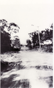
Photograph, Northcote Street, Mitcham, 8/09/1958 12:00:00 AM
Black and white photo of Northcote Street, Mitcham.- Eastern end of what is now Brunswick Road- Road (track ) conditions indicative of that part of the city.o'rourke, l. -
 Whitehorse Historical Society Inc.
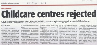
Article, Childcare Centres Rejected
Whitehorse councilors voted against a proposed childcare centre at 199 Canterbury Road, Blackburn and another at 310-312 Springvale Road, Forest Hill.Whitehorse councilors voted against a proposed childcare centre at 199 Canterbury Road, Blackburn and another at 310-312 Springvale Road, Forest Hill.Whitehorse councilors voted against a proposed childcare centre at 199 Canterbury Road, Blackburn and another at 310-312 Springvale Road, Forest Hill.city of whitehorse, child care centres, canterbury road, blackburn no. 199, springvale road, forest hill no 310 - 312 -
 Whitehorse Historical Society Inc.
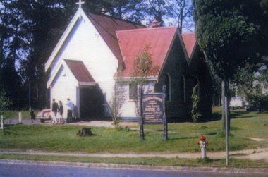
Photograph, St Luke's, Vermont
In 1922 the building was extended. In 1961 it was moved to it's present location at the rear of the church property. In 1999 it was restored and is now know as 'The Pioneer Church'Coloured photo of the original St Luke's Church, Vermont. It was erected on the corner of Mitcham Road & Canterbury Roads Vermont, and dedicated on 3rd September 1907st luke's vermont, canterbury road vermont -
 Canterbury History Group
Photograph - Rear view of 3 shops in Maling Road. View from the Wattle Valley Road car park, Jan Pigot, 1994
Coloured photograph of the rear view of 3 shops, No. 114, 116 and 118 Maling Road. View from the Wattle Valley Road car park.canterbury, maling road, shops -
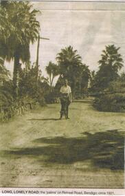 Bendigo Historical Society Inc.
Newspaper - JENNY FOLEY COLLECTION: LONG LONELY ROAD
BHS CollectionBendigo Advertiser ''The way we were'' from 2002. Long lonely road: the palms on Retreat Road, Bendigo circa 1921. The clip is in a folder.newspaper, bendigo advertiser, the way we were -
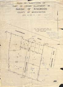 Ringwood and District Historical Society
Map - Plan of Subdivision, Part of Crown Allotment 39, Parish of Ringwood, County of Mornington - (Undated - circa 1930s)
Copy of land title map on light cardboard backing showing layout and size of 11 allotments in Canterbury Road and Culverlands Road, Heathmont, Victoria. Hand-written sales notations on map and backing include names and telephone numbers - Mr Robinson MJ2411, Mr Smith MX5425, Abicare WY1848. Later notation 12/12/67 - A. Robertson. Rubber stamp imprint in top left corner - D.H. Oliver, Civil Engineer & Licensed Surveyor, Bellevue Street Lilydale, Phone Lilydale 91. -
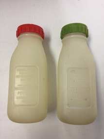 Kew Historical Society Inc
Container - Model Dairy Plastic Milk Bottles, Model Dairy, c.1960
This pair of milk bottles, produced for the Model Dairy in Cotham Road, Kew, were donated by Vik Sabaliauskas. They belonged to his father who worked at Model Dairy in the 1950s and 1960s. Vik wrote about his father: "As for my father, his whole life story is interesting. He was part of the big immigration program after WW2. He was a displaced person in Germany like lots of others who came out looking for a new life. Our family name is actually SABALIAUSKAS which is of Lithuanian descent. My Dad was also named Vik (Viktoras). He was known as Big Vik and I was little Vik. He arrived in Australia in 1947 and then did his 2 years of work organised by the Government and then he came to Melbourne. We lived in Tyler St Preston and he rode his pushbike to and from Kew every working day for years. In my estimation that was about 13 kms for about 6 or 7 years. Imagine that happening today. Freezing Winter mornings and hot Summer afternoons. His English was poor but he had a great work ethic like all European immigrants. His duties related to maintaining and operating all the machines. One story that he told me about was that after I was born (in 1959) he made friends with one of the drivers who delivered milk to the dairy. He asked him to get a container of milk from the farmer everyday which was just for me. I remember going to the Model Dairy Family Christmas parties which were always well patronised. I also remember visiting him in the PANCH Hospital (Bell Street Preston) where he was treated for kidney stones caused by drinking very creamy milk. He wasn't happy when he was told by the doctor to cut back on milk. My Dad was one month short of his 95th birthday when he died and he lived a pretty healthy life." (2019)Kew was a major milk producing district in the Nineteenth and early Twentieth centuries, with three major dairy farms lining the Yarra between Studley Park in the west and Burke Road in the east. In addition to these dairy producers, there were also a number of accredited dairy retailers in the suburb. The largest and most enduring of these was the Model Dairy founded by the Kew pioneer James Venn Morgan. Milk bottles that include the name of the producer or retailer are historically significant as they represent a period in Kew's history before the mass production of milk in the second half of the Twentieth Century. A number of these named bottles have the additional attribute of rarity.Pair of plastic milk bottles, designated on the front as to be used in the refigerator on on picnics. One bottle has a red screw on lid and the other a green lid. The bottles are semi-transparent. [The record also includes a photograph of Vic Sabaliauskas, provided by his son. The photograph dates from the period when he was employed at the Model Dairy].Impressed on the front of both bottles: "Unbreakable picnic and refrigerator bottle made expressly for Model Dairy Pty Ltd Cotham Rd Kew"dairies - kew, model dairy - cotham road - kew (vic) -
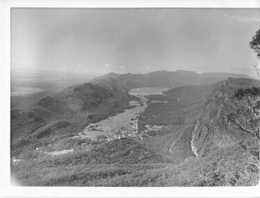 Halls Gap & Grampians Historical Society
Photograph - B/W
Photo has been taken from Boroka Peak/lookout, of the Fyans Valley and the township of Halls Gap. The Grampians/Dunkeld Road can be seen running North/South along the right edge of the valley and Lake Bellfield is the water at the end of the valley. Photo is typical of those taken by Forrests Commission at the timea photo of a valley, mostly cleared, flanked by two mountain ranges. A large body of water can be seen at the far end of the valley (middle of photo). Buildings and roads visible in the valley. Plains can be seen beyond the far mountain range on the left side of the scene.no.42scenery, fyans valley -
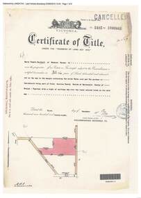 Ringwood and District Historical Society
Document, Certificate of Title - Harry Temple Marshall, Wesburn Farmer, Vic. - part of Crown Section 20, Parish of Warrandyte, County of Evelyn - 1928
A4 copies of Landata Victoria Historical Search documents - Vol 5485 Fol 1096803. Harry Temple Marshall is now the proprietor of an Estate in Fee-simple subject to the Encumbrances notified hereunder ... 10 acres 3 roods 10 perches or thereabouts, together with a right of carriage way over roads coloured brown. Subdivision map includes un-named roads - western side is Wonga Road (later Warranwood Road), and eastern side is Grandview Grove (later Bemboka Road), both north of Plymouth Road, Ringwood, Vic. Transfers include Harold Claude Howship, 1st December, 1928 James Bell McAlpin, 26th March, 1939. -
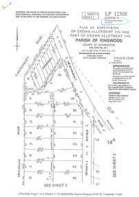 Ringwood and District Historical Society
Document - Subdivision Plan, LP12308 Crown Allotment 14C and Part of Crown Allotment 14A Parish of Ringwood, County of Mornington Vol 5378 Fol 511 - Circa 1927
LANDATA Land Victoria 4-sheet plan printout dated 2009.Sheet 1 includes Canterbury Road, Heathmont Road, Dickasons Road and Bennett Avenue, Heathmont. Additional markings include PC353066. Sheet 2 includes Heathmont Road, Bennett Avenue and Orchid Street, Heathmont. Additional markings include PS326369 and SP24567. Sheet 3 includes Dickasons Road and Bennett Avenue, Heathmont. Additional markings include LP46776, SP28005 and PS335189. Sheet 4 includes Dickasons Road, Bennett Avenue and Orchid Street, Heathmont. Additional markings include SP25998, SP31080, SP31780, SP25968, SP25969 and LP46475. -
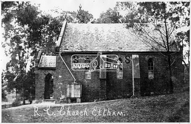 Eltham District Historical Society Inc
Negative - Photograph, Tom Prior, St Mary's Roman Catholic Church, Eltham, c.1900
The original St Mary’s Roman Catholic Church (1865-1912) was built of clay brick with buttress walls and a slate roof on the corner of Fordhams Road and Maria Street (Main Road), Eltham South, opposite the present-day Wingrove Park. It was blessed on September 3, 1865. With the arrival of the railway in 1901 and the town centre moving closer to the station, the decision was made to relocate the site of the church to its present-day location on Henry Street at the corner of Main Road. A new timber weatherboard church, also called St Mary's was erected and blessed on October 13, 1912. The church and land cost £1,400 (Evelyn Observer). The original brick church It was demolished in the 1920s and the bricks and windows were recycled to build a dairy on the Brinkkotter farm at Research. The timber church was destroyed by fire in 1961 and a new modern architectural (1960s) style church was erected in its place and named Our Lady of Help Christians Church.This photo forms part of a collection of photographs gathered by the Shire of Eltham for their centenary project book,"Pioneers and Painters: 100 years of the Shire of Eltham" by Alan Marshall (1971). The collection of over 500 images is held in partnership between Eltham District Historical Society and Yarra Plenty Regional Library (Eltham Library) and is now formally known as the 'The Shire of Eltham Pioneers Photograph Collection.' It is significant in being the first community sourced collection representing the places and people of the Shire's first one hundred years. The Reynolds family were early settlers in Research. The Reynolds/ Prior collection of photographs were taken by Tom Prior, the maternal uncle of Ivy Reynolds, around 1900 and the 60 photos in the album give a fine overview of many of the landmarks of Research and Eltham over 100 years ago. lvy lived in the family home for many years at 106 Thompson Cres Research. Ivy's father, Ernst Richard Reynolds and grandfather, Richard Reynolds, lived at the same address. Ivy's father Richard worked for Mr. Trail on his property in Research. Reynolds Road is named after the family. Mr Tom Prior (wife Eva) worked at the Melbourne zoo. He was very innovative and made his own camera, using the black cloth hood to exclude the light. The photographs are a reminder of the rural nature of Research and Eltham and its rich heritage.Digital image 4 x 5 inch B&W Negsepp, shire of eltham pioneers photograph collection, eltham, roman catholic church, brinkkotter, catholic church, church, reynolds prior collection, st marys catholic church -
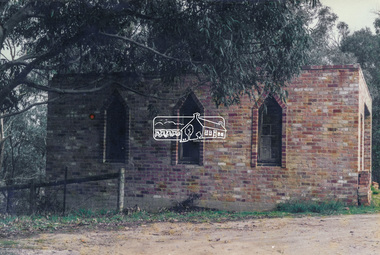 Eltham District Historical Society Inc
Photograph, Old dairy on the Brinkkotter farm, Research, Vic, Jul. 2001
The original St Mary’s Roman Catholic Church (1865-1912) was built of clay brick with buttress walls and a slate roof on the corner of Fordhams Road and Maria Street (Main Road), Eltham South, opposite the present-day Wingrove Park. It was blessed on September 3, 1865. With the arrival of the railway in 1901 and the town centre moving closer to the station, the decision was made to relocate the site of the church to its present-day location on Henry Street at the corner of Main Road. A new timber weatherboard church, also called St Mary's was erected and blessed on October 13, 1912. The church and land cost £1,400 (Evelyn Observer). The original brick church was demolished in the 1920s and the bricks and windows were recycled to build a dairy on the Brinkkotter farm at Research. The timber church was destroyed by fire in 1961 and a new modern architectural (1960s) style church was erected in its place and named Our Lady of Help Christians Church.Colour photographresearch (vic.), brinkkotter, catholic church, eltham, roman catholic church, st marys catholic church -
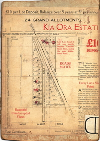 Kew Historical Society Inc
Plan - Subdivision Plan, Kia Ora Estate, 1930s
Twenty-five grand allotments were offered for sale in the subdivision known as the Kia Ora Estate in Balwyn in the early 1930s. The streets identified in the subdivision include Whitehorse Road, Barnsbury Road, Campbell Road, Mont Albert Road and Burke Road. The lots were advertised for £10 deposit, with the balance to be paid over 5 years at 5 per cent per annum. The lots bordering Whitehorse Road were nominated as potential valuable shop sites, while the Mont Albert Road lots were advertised as having ‘wonderful views’. The Outer Circle Railway Line is shown traversing the subdivision. The route of the Railway in this area is now a walking/bike track bordered by strips of parkland.subdivision plans - balwyn, kia ora estate -
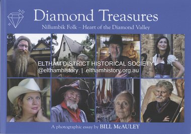 Eltham District Historical Society Inc
Book, Bill McAuley, Diamond Treasures : Nillumbik Folk - heart of the Diamond Valley / A photographic essay, 2024
A photographic essay and celebration of the artists, musicians and diverse characters who make Nillumbik so interesting. EDHS_07135 - School Crossing Supervisor, Jock Read on his horse Lofty supervising Eltham High School students crossing Main Road near Dalton Street, Eltham is reproduced in the bookartistic.portraits, diamond valley. nillumbik, photography, jock read -
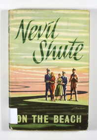 Marysville & District Historical Society
Book, Nevil Shute, On The Beach, 1958
After World War III, Australia is the only remaining haven for mankind. However, wind currents carrying lingering radiation all but condemn those on the continent to the same fate suffered by the rest of the world. When the survivors receive a strange signal from San Diego, Cmdr. Dwight Towers must undertake a mission with Lt. Peter Holmes to see if there is hope for humanity -- leaving behind Moira and Mary, the women they love.Dust cover is a painted illustration of the characters from the book.fictionAfter World War III, Australia is the only remaining haven for mankind. However, wind currents carrying lingering radiation all but condemn those on the continent to the same fate suffered by the rest of the world. When the survivors receive a strange signal from San Diego, Cmdr. Dwight Towers must undertake a mission with Lt. Peter Holmes to see if there is hope for humanity -- leaving behind Moira and Mary, the women they love.science fiction, end of the world, australia -
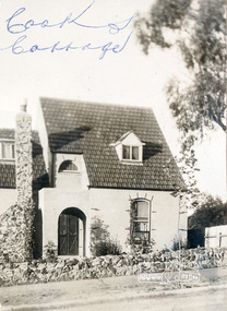 Eltham District Historical Society Inc
Photograph, Cook's Cottage; Mr. Ernie Andrew's home
Pages from a scrapbook belonging to Heather Jenkins (nee Sargeant) who lived as a child in the Police Residence at 728 Main Road, Eltham in the 1920s. The house was known locally as "Cook's Cottage" because of its resemblance to Captain Cook's Cottage in Fitzroy Gardens, Melbourne. See also 00183Heather Sargeant was the daughter of Constable W.C. Sargeant, the local police officer in residence at Eltham, 1922-1927Glued on a brown paper scrapbook page (torn from scrapbook) with 8 black and white/sepia photos of varying sizes, 1 newspaper clipping and one greeting card with printed sketch and handwritten captions in ink. On back of page is 1 black and white photo and a large newspaper clipping.eltham, police residence, heather jenkins (nee sargeant), walter withers, constable w.c. sargeant, cooks cottage, ernie andrew, ellen andrew -
 Eltham District Historical Society Inc
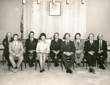
Photograph, Shire of Eltham Councillors, 1971, 1971
Formal photograph of Shire of Eltham Councilors, Shire of Eltham Council chambers. (Main road Eltham, now demolished). From left: Councillors John McConnell, Peter Graham, Alby Glover, Charis Pelling, Ben Taylor, Geoff Dreverman, Les Clarke, Bill Hale, Jim White.Black and white print 25.5 cm x 20.5 cmA2205 Hugh Fisher 82 Lygon St, Brunswick 3057 38-3040 6 York St, Eltham 3095 439-9046 councilors, shire of eltham, john mcconnell, peter graham, alby glover, charis pelling, ben taylor, les clarke, bill hale, jim white, geoffrey dreverman -
 Whitehorse Historical Society Inc.
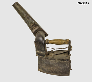
Domestic object - Charcoal Iron
Purchased for the collection by Barbara Gardiner at auctionAn example of the evolution of irons some of which date from the 1830sCast iron charcoal burning clothes iron. The main body has a lid which is opened by a handle which swings across to unlock the lid and swings back to lock under two brackets. The iron has a wooden handle and is supported by an upright which is cracked and wired together. There is a tin chimney attached to the outlet on the main body of the iron and a small trapdoor in the back.Kdomestic items, irons, domestic items, laundering -
 Falls Creek Historical Society
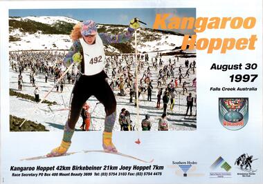
Poster - Kangaroo Hoppet 1997
The Kangaroo Hoppet is Australia’s premier long distance cross country ski race, and a member of the Worldloppet series of international cross country ski events. The first race at Falls Creek was held in 1979 under the name of “Australian Birkebeiner”. It was a 21km race with about 80 participants organised by the Birkebeiner Nordic Ski Club of Mount Beauty. The course started and finished at Falls Creek Alpine Resort and took participants out into the Bogong High Plains. After running the event for 10 years, it was decided they should become part of the Worldloppet series of marathon ski races. Representatives from the Birkebeiner Nordic Ski Club and the Australian Ski Federation attended the Worldloppet Annual Meeting in Finland in June 1990 to put the case for the acceptance of an Australian event into the Worldloppet series. Before being admitted, they had to demonstrate that the Birkebeiner Club could run a world class event, so three months later in August 1990 a 42km event named the Australian International Ski Marathon was held at Falls Creek together with a 21km Birkebeiner race and a 7km event called the Birkebeiner Lite. The event was approved by delegates from USA, Norway and Austria, in 1991 Australia became the 12th member of Worldloppet, with the condition that there had to be a name change. After some late night discussion allegedly involving red wine from North East Victoria the main event became the 42km Kangaroo Hoppet, with the minor events being the 21km Australian Birkebeiner, and 7km Joey Hoppet. In the winter of 1991, the first Kangaroo Hoppet was held. It was a great success and has been a regular fixture on the international ski calendar ever since. It features the main 42km event as well as a 21km event and a 7km event. The Hoppet brings the Australian snowfields to an international audience. In 1997 the Men's Winner was Paul Gray from Australia in a time of 1:43:07. The winner of the Women's event was Camille Melvey of Australia in a time of 2:06:58.This poster is significant because it documents an event which brings international attention to Falls Creek and the surrounding region.A large poster featuring a main image of many skiers on the slopes, with a larger image of a female skier superimposed over it. A title is written in the top left section of the poster in orange text. Remaining text is in black. The logos of Worldloppet, Southern Hydro, Alpine Resorts Commission Victoria and the Birkebeiner Nordic Ski Club are also included in the left side of the poster. In top left: Kangaroo Hoppet / August 30 1997 Falls Creek Australia At the bottom beneath images: Kangaroo Hoppet 42km Birkebeiner 21km Joey Hoppet 7km Race Secretary P.O. Box 400 Mt. Beauty 3699 Tel: (03) 5754 3103 Fax: (03) 5754 4475kangaroo hoppet, worldloppet events, falls creek, mt. beauty -
 Whitehorse Historical Society Inc.
Photograph, Site of Barnard's Corner Store
Laser Print of black and white photo of Site of Barnard's Corner Store (2 copies) Boronia Road and Canterbury Road, Vermont. (Mounted) Barnard's Store was on the south-west corner of Canterbury Road and L.L. Vale Road (Boronia Road) Vermont. The old store was run by Miss Barnard. Mr Barnard had a Farriers Shop at the back of the store. The white gates on back centre of photograph in Canterbury Road is entrance to Uplands, home of Edward Bishop and Dr. Stephens. White fence on right hand side of photograph is entrance to home of Mr. & Mrs. Tilson who was a market gardener and orchardist.barnards corner store, uplands, vermont, stephens, dr., tilson, mr., tilson mrs, bishop, edward -
 Melbourne Tram Museum
Document - Research Notes, H. S. McComb, development and timing of the "PMTT" - part 4, 1950's
Set of papers, handwritten concerning the development and timing of the "PMTT", Prahran and Malvern - about 40 sheets. Prepared by H. S. McComb - gives layout of the PMTT system, primarily of Burke Road, sketches of track layout, opening dates, sketches of various junctions, bridges, track miles, junctions, reconciliation of track lengths from various sources includes Glenferrie and Cotham Road, Balaclava Road, Hawthorn Road, Glenhuntly Road, Waverley Road and St Kilda Esplanade, Candy Corner. Items 2041 to 2052 within box 72.3 in a brown folder marked "PMTT" in red pencil.trams, tramways, pmtt, malvern, routes, track, surveys, glenferrie rd, cotham rd, balaclava rd, hawthorn rd, waverley rd, st kilda, candy corner -
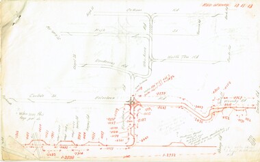
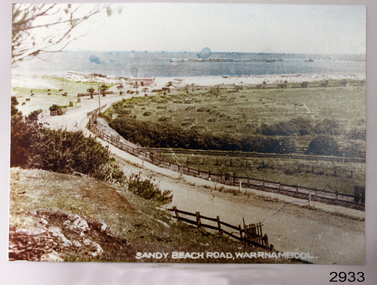 Flagstaff Hill Maritime Museum and Village
Photograph
Photograph of Sandy Beach Road Warrnambool. Colouredflagstaff hill, warrnambool, shipwrecked-coast, flagstaff-hill, flagstaff-hill-maritime-museum, maritime-museum, shipwreck-coast, flagstaff-hill-maritime-village -
 Glen Eira Historical Society
Railways in Caulfield
Photograph of Glen Huntly Road looking eastglen huntly, glen huntly road -
Glenelg Shire Council Cultural Collection
Photograph - Photograph - Road, trees, paddocks, n.d
Black and white photograph. Road, trees, paddocksBack: 'Press Photographic Service' purple stamp '8; - blue biro -
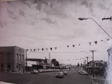 Glenelg Shire Council Cultural Collection
Photograph - Photograph - Main Street Portland, Victoria, n.d
GSC records. Portland Development CommitteeView of an intersection and wide road with shops and flags.Back: Portland Development Committee (centre, blue stamp) -
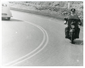 Victoria Police Museum
Photograph (police motorcycle)
Harley Davidson on open road. Circa 1947police vehicles; wireless patrol; motor transport branch; motor transport section; motor cycle branch; police motorcycles; harley davidson motorcycle -
Ringwood and District Historical Society
Envelope, Packet: Roads: Ringwood Bypass Cuttings 1990-91
Roads - Bypass 1990-1991 Packet 1 -
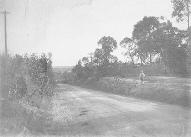 Ringwood and District Historical Society
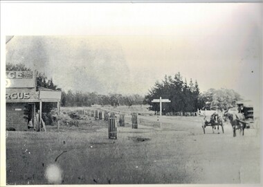
Photograph, Wonga Rd. 1909
With small boy standing on bank at edge of roadWritten on back of smaller photograph, "Wonga Rd. 1909". -
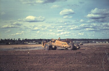 Bendigo Historical Society Inc.
Slide - BENDIGO & EASTER FAIR, c1963
Construction of Showgrounds, Holmes Road, North Bendigo.slide, bendigo, bendigo showgrounds