Showing 215 items
matching 'guildford'
-
 Glen Eira Historical Society
Book - CAULFIELD CENTENARY 1957
This file contains four items 1/Two copies of a twenty-four page booklet titled CITY OF CAULFIELD CENTENARY 1857-1957, created by the Caulfield City Council and printed by Peter Isaacson Pty Limited, Melbourne. The booklet details important aspects of Caulfield’s history including council procedures, the Caulfield Road District Proclamation, the first election and a summary of 100 years of local government with a description of the present Caulfield in 1957. The booklet also includes several pictures of various Caulfield landmarks and people including one of Caulfield City Councillors (11 men and 1 woman). Also one photocopied version of this booklet. 2/Eleven pages of typed notes for the City of Caulfield Centenary booklet. All notes are undated and incomplete. Two pages titled NOTES on THE HISTORY and PROGRESS OF THE CITY OF CAULFIELD, author unknown. Three and a half pages titled THE STRUCTURE OF LOCAL GOVERNMENT IN VICTORIA, author unknown. Five pages titled 100 YEARS OF LOCAL GOVERNMENT – EARLY CAULFIELD, by Mrs A. P. Bell. 3/A typed letter to Miss V. Webb-Langdon from the Town Clerk H.G. Nelson, acknowledging her contribution to historical details for the Caulfield Council’s Centenary booklet, dated 24/12/1957. 4/A handwritten letter and a handwritten note regarding the acquisition of notes for the Caulfield Centenary booklet. The letter is dated 03/08/2006 and the note is dated 09/02/2007.city of caulfield centenary, caulfield road district, sinclair a.j.g., city hall, war memorials, gamble h.a., machin l.r., bunny f.c.d., caulfield park, koornang reserve, parton e.m., sims h.e., thomson w.r., gunn e.e., yorston j.s., wallace g.e. mrs, green w.c., jenner e.r., ward boundaries, dandenong road, queens avenue, normanby road, station street, bond street, glen eira road, orrong road, poath road, north road, booran road, nepean highway, glen huntly road, glenhuntly road, inkerman road, hotham street, nelson h.g., fullard w.r., mackley g.j., ellis k.i, crosbie m.r., nutting b.i., body j.h., pritchard r.j., guildford l.t.g., lund l.m., street h.c., reynolds a.w., elections , political processes, local government, springthorpe reserve, greenmeadows gardens, business and finance, roads and streets, caulfield racecourse, east caulfield reserve, mackinnon reserve, hawthorn road, balaclava road, murrumbeena road, lempriere avenue, victoria street, koornang road, lord reserve, lyons street, murrumbeena reserve, kangaroo road, ormond park, beatty crescent, foch street, packer reserve, oakleigh road, leila road, prices park, bambra road, riley reserve, playgrounds, town hall, maternal and child health centres, truganini road, grange road, senior citizens centre, barkley sir henry, moore david, handasyde gilbert, caulfield school room, harris g.w., semple john, dempsey william, brooks w.a., wilson thomas, lyall william, murrum murrumbeen lifestyle, ‘greenmeadows’ house, lempriere family, aboriginal culture, ‘rippon lea’ house, caulfield john, ‘slaney’s’ home, alma road, paddy’s swamp, racecourse hotel, caulfield technical college, bevan mr., ‘grosmont’, hart john, railways, mansions, ‘rosecraddock’, langdon h. j., caulfield cup, ‘crotonhurst’, webb judge, ‘kilwinning’, service james, ricketson henry, ‘glen eira’, house names, garden vale, ross william murray, ‘ross’s folly’, outer circle railway, caulfield grammar school, davies j. henry, lagdon william, grimwade f.s., loyd charles du plan, hope george, ‘airdrie’, kooyong hill, market gardens, dairies, lady talbot milk supply, jenner family, o’niell college, presentation sisters, glenferrie road, grimwade frederick sheppard, grimwade alice, ‘harlston’, grimwade house, ‘saint aubin’s’, ‘st. aubin’s’, ‘caulfield hall’, caulfield john p.t., st georges road, caulfield military hospital, nursing homes, health establishments, dover street, sports and recreations, rosanna street, ‘cantala’, health services, parks and reserves, community services, town planning, local government finance, local officials and employees -
 Federation University Historical Collection
Book, Victorian Government Legislative Assembly, The Select Committee on Castlemaine and Sandhurst water supply, Report from the Select Committee on Castlemaine and Sandhurst Water Supply, together with the proceedings of the Committee, minutes of evidence and appendices, 19/5/1865 (exact)
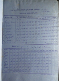
This book contains the report from the select committee on Castlemaine and Sandhurst water supply; with the proceedings of the committee, minutes of evidence and appendices. It also contains the report Of the Engineer-In-Chief of Railways, and reply of the Chief Engineer of Water Supply on the works constructed by the Victorian Water Supply Department, presented to both houses of parliament by His Excellency’s command. Ferdinand M. Krause, was a lecturer at the Ballarat School of Mines in Geology Mineralogy Mining Engineering and Surveying. He was a Fellow of the Geological Society and a Fellow of the Linnian Society. He was assistant engineer for the Ballaarat and Ballarat East Water Supply Committee and helped plan local reservoirs.A brown cloth hard cover, foolscap book with leather spine. Title is written in black on the title page. "Water Supply Reports" is engraved in gold on spine. It includes a table showing the monthly and yearly rainfall and shade temperature at Ballarat, 2nd February, 1885. It also includes two reports and two replies, a map No.7082.2 of Victorian Water Supply, Castlemaine and Sandhurst district general plan including lines of Aqueduct, Reservoirs. No. 7082.3 of Victorian Mining districts, Mining Divisions and The Gold Fields in 1866 - includes districts to be supplied under the Waterworks Act, 1965. It also includes: *Report of the Engineer-in-chief of Railways and Reply of the Chief Engineer of Water Supply on the works constructed by the Victorian Water Supply Department, 1869. * Coliban Water Scheme, 1864 * Ballarat and Ballarat East Water Supply (1869) including the Ballarat Water Supply List containing names of occupiers and nature of improvements on lands comprised within the proposed reserve of Gong Gong Reservoir, Ballaarat. At Warrenheip the names included: Honora McCallin, William Honan, C. McMahon, Patrick McMahon, J.P. Beach, J.H. Smith, Michael Nestor, Martin Quinn, Martin McIntyre, Robert Higgins, Coleman Kane, Robert Bond. At Ballarat: William Clarke, Richard White, John Hosking, Wesleyan Chapel, J. Hewitt, Robert McRobinson. At Bungaree: John Pullin, John Llewellyn. William Daw, Smith and Wynne, William Brough, A. Alexander. * Ballarat and Ballaarat East Water Supply report upon the advisability, or otherwise, of constructing a reservoir at the junction of the Yarrowee Creek and Gile's Creek, upon a site known as Gile's Reservoir (printed by Frank Pinkerton). This report has numerous notes written on it (most probably by Krause) and includes the capacity of Harry Beale's Reservoir, Pimcott's Reservoir and the Proposed Gong Gong Reservoir. * Statement as to the position of the Ballaarat and Ballaarat East Borough Councils in Connection with Water Supply, September 1869. * Ballarat and Ballaarat East Water Supply - General Statement upon the Ballaarat and Ballaarat east Scheme of Water Supply. Includes information on Moorabool reservoir, Harry Beale's Reservoir, Lal Lal Creek, Two Mile Creek, Beale's Dam, Yarrowee Creek, Gong Gong Reservoir, Kirk's Dam, Devil's Creek, Moorabool Creek. Additional handwritten notes (probably by Krause) * Engineer's Report on the resolution of the COmmittee of Water Supply, of the 7th July 1868. The report refers to the Country around Mount Warrenheip. Names mentioned are L. Abraham, Great North-West Gold Mining Company, Border Sawmills, Ferdinand Krause, Ohlfsen Bagge, W.H. Shaw, A signature by "Ferdinand M. Krause" at the top corner of the title page. A few pages have handwriting on the margins, it is believed to be his handwriting. water supply victoria, castlemaine directories, sandhurst directories, ballarat directories, james blackburn, edward wardle, daylesford water race, c j taylor, george avery fletcher, bagge, ohlfsen bagge, george foote, john h reilly, ambrose johnson, george francis, timber preservation, james forbes, alfred surplice, malcolm carmichael, robert adams, frederick hugh thomas, h o christerpherson, william downe, thomas lawrence brown, francis hadgson nixon, strangways, guildford, maldon, muckleford, lauriston, malmesbury, franklinford, walmer, strathloddon, downe, ferdinand krause, m7082, trentham, castlemaine, drummond, metcalfe, sutton grange, lockwood, ravenswood, mandurang, yandoit, c.h. ohlfsen bagge, moorabool reservoir, gong gong reservoir, harry beale's reservoir, pincott reservoir, frank pinkerton, water -
 Federation University Historical Collection
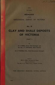
Book, Memoirs of the Geological Survey of Victoria; No 18, Clay and Shale Deposits of Victoria, 1952
Grey soft covered book with red tape spine. The 76 pages clay deposits, composition of Victorian clays, clay localities, granitic clays, Residual Clays, Clay-Shales, Jurassic clay shales.r a keble, senior field geologist, j c watson, chief chemist, d e watson, chief government geologist, g c moss, minister of mines, mallee plains, avoca valley, loddon valley, campaspe valley, goulburn valley, kiewa, mitta, glenelg valley, pitfield valley, otway area, moorabool valley, darley fireclay, campbellfield clay, latrobe river valley, hendley, ball clays, felspars, pegmatities, quartz, pakenham fireclay, bulla china clay, kaolin, terracotta, stoneware, ballan dyke-belt, egerton, gordon, ballan, llandeilo, colbrook, elaine, lal lal, maryborough, ballarat, ringwood, siliceous clay, stawell, dromana, ptways, bulla, pyalong china clay, linton china clay, wedderburn clays, lal lal china clays, ballan dyke belt, reginald callister, knight's koalin pottery, china clay, ferdinand krause, clarendon, bittern, frichot, hunt's dam, vaughan, rosenow, hickey, malone, claypits, ballarat dyke belt, stawell dyke belt, maryborough dyke belt, guildford, daylesford, ovens valley -
 Ballarat Heritage Services
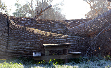
Digital Photograph, L.J. Gervasoni, Crushed picnic table at Warrnambool, c2015
Colour photograph of a crushed picnic table, which occured when a limb fell from a tree at Warrnambool.guildford, picnic, oak, damage, picnic table -
Surrey Hills Historical Society Collection
Folder of real estate advertisements, Folders of real estate advertisements (Streets beginning with G), Various
A4 folders with individual pockets for each property in streets beginning with G located in Surrey Hills and Mont Albert. Folders are ordered by street name and then chronologically by property number. Each property has its own pocket. This may include multiple real estate advertisements collected from sales over time. It may also include copies of any research undertaken by Alan Holt and / or members of the SHNCHC team. These are augmented by cards in the Alan Holt index file and by his property registers of Surrey Hills and Mont Albert.gawler court, george street, gilbert street, gladstone street, glendale street, godfrey court, goodwood street, gordon street, grace court, graham street, grange street, griffin close, grovedale road, guildford road -
 Surrey Hills Historical Society Collection
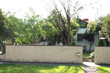
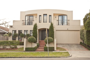
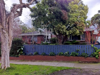
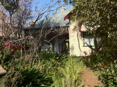
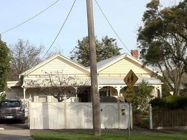
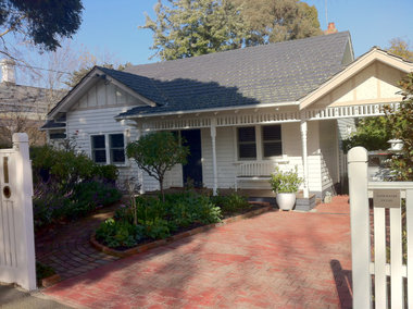
Photograph - 1 Guildford Road, Surrey Hills, The Street Where You Live Project
Photos documenting this address as part of a photographic series undertaken by volunteer photographers during 2013 and 2014 for The Street Where You Live Project. This was organised through the Surrey Hills Neighbourhood Centre and covered the postcode 3127 in the cities of Boroondara and Whitehorse.These photos provide a snapshot of real estate in the suburbs of Mont Albert and Surrey Hills during a period of rapid change with many properties on large blocks demolished to create higher density residential development or renewal of single dwellings. At particular risk were properties not covered by heritage overlays, especially interwar housing and post 1950's housing. -
 Surrey Hills Historical Society Collection
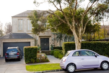
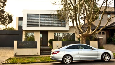
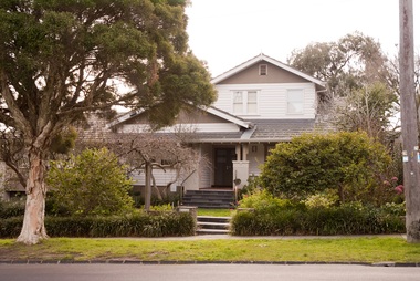
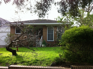
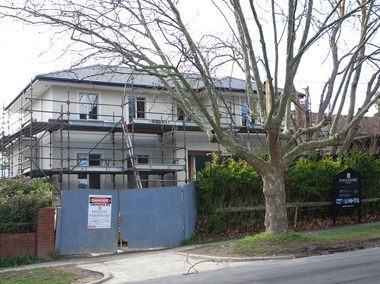
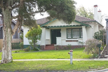
Photograph - 3 Guildford Road, Surrey Hills, The Street Where You Live Project
Photos documenting this address as part of a photographic series undertaken by volunteer photographers during 2013 and 2014 for The Street Where You Live Project. This was organised through the Surrey Hills Neighbourhood Centre and covered the postcode 3127 in the cities of Boroondara and Whitehorse.These photos provide a snapshot of real estate in the suburbs of Mont Albert and Surrey Hills during a period of rapid change with many properties on large blocks demolished to create higher density residential development or renewal of single dwellings. At particular risk were properties not covered by heritage overlays, especially interwar housing and post 1950's housing. -
 Surrey Hills Historical Society Collection
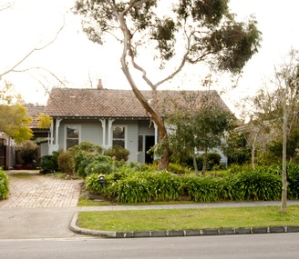
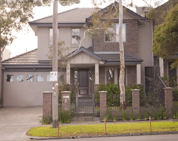
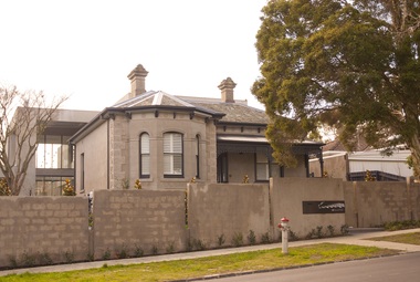
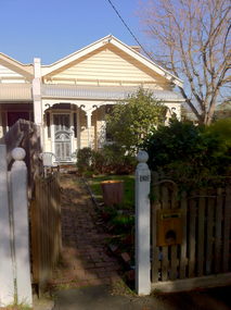
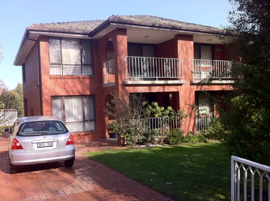
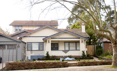
Photograph - 5 Guildford Road, Surrey Hills, The Street Where You Live Project
Photos documenting this address as part of a photographic series undertaken by volunteer photographers during 2013 and 2014 for The Street Where You Live Project. This was organised through the Surrey Hills Neighbourhood Centre and covered the postcode 3127 in the cities of Boroondara and Whitehorse.These photos provide a snapshot of real estate in the suburbs of Mont Albert and Surrey Hills during a period of rapid change with many properties on large blocks demolished to create higher density residential development or renewal of single dwellings. At particular risk were properties not covered by heritage overlays, especially interwar housing and post 1950's housing. -
 Surrey Hills Historical Society Collection
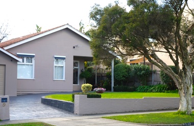
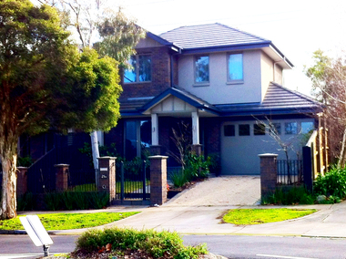
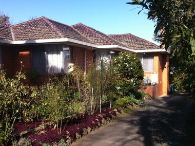
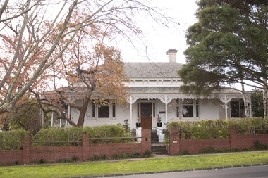
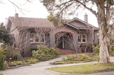
Photograph - 7 Guildford Road, Surrey Hills, The Street Where You Live Project
Photos documenting this address as part of a photographic series undertaken by volunteer photographers during 2013 and 2014 for The Street Where You Live Project. This was organised through the Surrey Hills Neighbourhood Centre and covered the postcode 3127 in the cities of Boroondara and Whitehorse.These photos provide a snapshot of real estate in the suburbs of Mont Albert and Surrey Hills during a period of rapid change with many properties on large blocks demolished to create higher density residential development or renewal of single dwellings. At particular risk were properties not covered by heritage overlays, especially interwar housing and post 1950's housing. -
 Surrey Hills Historical Society Collection
Photograph - 9 Guildford Road, Surrey Hills, The Street Where You Live Project
Photos documenting this address as part of a photographic series undertaken by volunteer photographers during 2013 and 2014 for The Street Where You Live Project. This was organised through the Surrey Hills Neighbourhood Centre and covered the postcode 3127 in the cities of Boroondara and Whitehorse.These photos provide a snapshot of real estate in the suburbs of Mont Albert and Surrey Hills during a period of rapid change with many properties on large blocks demolished to create higher density residential development or renewal of single dwellings. At particular risk were properties not covered by heritage overlays, especially interwar housing and post 1950's housing. -
 Surrey Hills Historical Society Collection
Photograph - 11 Guildford Road, Surrey Hills, The Street Where You Live Project
Photos documenting this address as part of a photographic series undertaken by volunteer photographers during 2013 and 2014 for The Street Where You Live Project. This was organised through the Surrey Hills Neighbourhood Centre and covered the postcode 3127 in the cities of Boroondara and Whitehorse.These photos provide a snapshot of real estate in the suburbs of Mont Albert and Surrey Hills during a period of rapid change with many properties on large blocks demolished to create higher density residential development or renewal of single dwellings. At particular risk were properties not covered by heritage overlays, especially interwar housing and post 1950's housing. -
 Surrey Hills Historical Society Collection
Photograph - 17 Guildford Road, Surrey Hills, The Street Where You Live Project
Photos documenting this address as part of a photographic series undertaken by volunteer photographers during 2013 and 2014 for The Street Where You Live Project. This was organised through the Surrey Hills Neighbourhood Centre and covered the postcode 3127 in the cities of Boroondara and Whitehorse.These photos provide a snapshot of real estate in the suburbs of Mont Albert and Surrey Hills during a period of rapid change with many properties on large blocks demolished to create higher density residential development or renewal of single dwellings. At particular risk were properties not covered by heritage overlays, especially interwar housing and post 1950's housing. -
 Surrey Hills Historical Society Collection
Photograph - 19 Guildford Road, Surrey Hills, The Street Where You Live Project
Photos documenting this address as part of a photographic series undertaken by volunteer photographers during 2013 and 2014 for The Street Where You Live Project. This was organised through the Surrey Hills Neighbourhood Centre and covered the postcode 3127 in the cities of Boroondara and Whitehorse.These photos provide a snapshot of real estate in the suburbs of Mont Albert and Surrey Hills during a period of rapid change with many properties on large blocks demolished to create higher density residential development or renewal of single dwellings. At particular risk were properties not covered by heritage overlays, especially interwar housing and post 1950's housing. -
 Surrey Hills Historical Society Collection
Photograph - 21 Guildford Road, Surrey Hills, The Street Where You Live Project
Photos documenting this address as part of a photographic series undertaken by volunteer photographers during 2013 and 2014 for The Street Where You Live Project. This was organised through the Surrey Hills Neighbourhood Centre and covered the postcode 3127 in the cities of Boroondara and Whitehorse.These photos provide a snapshot of real estate in the suburbs of Mont Albert and Surrey Hills during a period of rapid change with many properties on large blocks demolished to create higher density residential development or renewal of single dwellings. At particular risk were properties not covered by heritage overlays, especially interwar housing and post 1950's housing. -
 Surrey Hills Historical Society Collection
Photograph - 23 Guildford Road, Surrey Hills, The Street Where You Live Project
Photos documenting this address as part of a photographic series undertaken by volunteer photographers during 2013 and 2014 for The Street Where You Live Project. This was organised through the Surrey Hills Neighbourhood Centre and covered the postcode 3127 in the cities of Boroondara and Whitehorse.These photos provide a snapshot of real estate in the suburbs of Mont Albert and Surrey Hills during a period of rapid change with many properties on large blocks demolished to create higher density residential development or renewal of single dwellings. At particular risk were properties not covered by heritage overlays, especially interwar housing and post 1950's housing. -
 Surrey Hills Historical Society Collection
Photograph - 25 Guildford Road, Surrey Hills, The Street Where You Live Project
Photos documenting this address as part of a photographic series undertaken by volunteer photographers during 2013 and 2014 for The Street Where You Live Project. This was organised through the Surrey Hills Neighbourhood Centre and covered the postcode 3127 in the cities of Boroondara and Whitehorse.These photos provide a snapshot of real estate in the suburbs of Mont Albert and Surrey Hills during a period of rapid change with many properties on large blocks demolished to create higher density residential development or renewal of single dwellings. At particular risk were properties not covered by heritage overlays, especially interwar housing and post 1950's housing. -
 Surrey Hills Historical Society Collection
Photograph - 27 Guildford Road, Surrey Hills, The Street Where You Live Project
Photos documenting this address as part of a photographic series undertaken by volunteer photographers during 2013 and 2014 for The Street Where You Live Project. This was organised through the Surrey Hills Neighbourhood Centre and covered the postcode 3127 in the cities of Boroondara and Whitehorse.These photos provide a snapshot of real estate in the suburbs of Mont Albert and Surrey Hills during a period of rapid change with many properties on large blocks demolished to create higher density residential development or renewal of single dwellings. At particular risk were properties not covered by heritage overlays, especially interwar housing and post 1950's housing. -
 Surrey Hills Historical Society Collection
Photograph - 28 Guildford Road, Surrey Hills, The Street Where You Live Project
Photos documenting this address as part of a photographic series undertaken by volunteer photographers during 2013 and 2014 for The Street Where You Live Project. This was organised through the Surrey Hills Neighbourhood Centre and covered the postcode 3127 in the cities of Boroondara and Whitehorse.These photos provide a snapshot of real estate in the suburbs of Mont Albert and Surrey Hills during a period of rapid change with many properties on large blocks demolished to create higher density residential development or renewal of single dwellings. At particular risk were properties not covered by heritage overlays, especially interwar housing and post 1950's housing. -
 Surrey Hills Historical Society Collection
Photograph - 30 Guildford Road, Surrey Hills, The Street Where You Live Project
Photos documenting this address as part of a photographic series undertaken by volunteer photographers during 2013 and 2014 for The Street Where You Live Project. This was organised through the Surrey Hills Neighbourhood Centre and covered the postcode 3127 in the cities of Boroondara and Whitehorse.These photos provide a snapshot of real estate in the suburbs of Mont Albert and Surrey Hills during a period of rapid change with many properties on large blocks demolished to create higher density residential development or renewal of single dwellings. At particular risk were properties not covered by heritage overlays, especially interwar housing and post 1950's housing. -
 Surrey Hills Historical Society Collection
Photograph - 31 Guildford Road, Surrey Hills, The Street Where You Live Project
Photos documenting this address as part of a photographic series undertaken by volunteer photographers during 2013 and 2014 for The Street Where You Live Project. This was organised through the Surrey Hills Neighbourhood Centre and covered the postcode 3127 in the cities of Boroondara and Whitehorse.These photos provide a snapshot of real estate in the suburbs of Mont Albert and Surrey Hills during a period of rapid change with many properties on large blocks demolished to create higher density residential development or renewal of single dwellings. At particular risk were properties not covered by heritage overlays, especially interwar housing and post 1950's housing. -
 Surrey Hills Historical Society Collection
Photograph - 32 Guildford Road, Surrey Hills, The Street Where You Live Project
Photos documenting this address as part of a photographic series undertaken by volunteer photographers during 2013 and 2014 for The Street Where You Live Project. This was organised through the Surrey Hills Neighbourhood Centre and covered the postcode 3127 in the cities of Boroondara and Whitehorse.These photos provide a snapshot of real estate in the suburbs of Mont Albert and Surrey Hills during a period of rapid change with many properties on large blocks demolished to create higher density residential development or renewal of single dwellings. At particular risk were properties not covered by heritage overlays, especially interwar housing and post 1950's housing. -
 Surrey Hills Historical Society Collection
Photograph - 33 Guildford Road, Surrey Hills, The Street Where You Live Project
Photos documenting this address as part of a photographic series undertaken by volunteer photographers during 2013 and 2014 for The Street Where You Live Project. This was organised through the Surrey Hills Neighbourhood Centre and covered the postcode 3127 in the cities of Boroondara and Whitehorse.These photos provide a snapshot of real estate in the suburbs of Mont Albert and Surrey Hills during a period of rapid change with many properties on large blocks demolished to create higher density residential development or renewal of single dwellings. At particular risk were properties not covered by heritage overlays, especially interwar housing and post 1950's housing. -
 Surrey Hills Historical Society Collection
Photograph - 34 Guildford Road, Surrey Hills, The Street Where You Live Project
Photos documenting this address as part of a photographic series undertaken by volunteer photographers during 2013 and 2014 for The Street Where You Live Project. This was organised through the Surrey Hills Neighbourhood Centre and covered the postcode 3127 in the cities of Boroondara and Whitehorse.These photos provide a snapshot of real estate in the suburbs of Mont Albert and Surrey Hills during a period of rapid change with many properties on large blocks demolished to create higher density residential development or renewal of single dwellings. At particular risk were properties not covered by heritage overlays, especially interwar housing and post 1950's housing. -
 Surrey Hills Historical Society Collection
Photograph - 35 Guildford Road, Surrey Hills, The Street Where You Live Project
Photos documenting this address as part of a photographic series undertaken by volunteer photographers during 2013 and 2014 for The Street Where You Live Project. This was organised through the Surrey Hills Neighbourhood Centre and covered the postcode 3127 in the cities of Boroondara and Whitehorse.These photos provide a snapshot of real estate in the suburbs of Mont Albert and Surrey Hills during a period of rapid change with many properties on large blocks demolished to create higher density residential development or renewal of single dwellings. At particular risk were properties not covered by heritage overlays, especially interwar housing and post 1950's housing. -
 Surrey Hills Historical Society Collection
Photograph - 36 Guildford Road, Surrey Hills, The Street Where You Live Project
Photos documenting this address as part of a photographic series undertaken by volunteer photographers during 2013 and 2014 for The Street Where You Live Project. This was organised through the Surrey Hills Neighbourhood Centre and covered the postcode 3127 in the cities of Boroondara and Whitehorse.These photos provide a snapshot of real estate in the suburbs of Mont Albert and Surrey Hills during a period of rapid change with many properties on large blocks demolished to create higher density residential development or renewal of single dwellings. At particular risk were properties not covered by heritage overlays, especially interwar housing and post 1950's housing. -
 Surrey Hills Historical Society Collection
Photograph - 37 Guildford Road, Surrey Hills, The Street Where You Live Project
Photos documenting this address as part of a photographic series undertaken by volunteer photographers during 2013 and 2014 for The Street Where You Live Project. This was organised through the Surrey Hills Neighbourhood Centre and covered the postcode 3127 in the cities of Boroondara and Whitehorse.These photos provide a snapshot of real estate in the suburbs of Mont Albert and Surrey Hills during a period of rapid change with many properties on large blocks demolished to create higher density residential development or renewal of single dwellings. At particular risk were properties not covered by heritage overlays, especially interwar housing and post 1950's housing. -
 Surrey Hills Historical Society Collection
Photograph - 38 Guildford Road, Surrey Hills, The Street Where You Live Project
Photos documenting this address as part of a photographic series undertaken by volunteer photographers during 2013 and 2014 for The Street Where You Live Project. This was organised through the Surrey Hills Neighbourhood Centre and covered the postcode 3127 in the cities of Boroondara and Whitehorse.These photos provide a snapshot of real estate in the suburbs of Mont Albert and Surrey Hills during a period of rapid change with many properties on large blocks demolished to create higher density residential development or renewal of single dwellings. At particular risk were properties not covered by heritage overlays, especially interwar housing and post 1950's housing. -
 Surrey Hills Historical Society Collection
Photograph - 39 Guildford Road, Surrey Hills, The Street Where You Live Project
Photos documenting this address as part of a photographic series undertaken by volunteer photographers during 2013 and 2014 for The Street Where You Live Project. This was organised through the Surrey Hills Neighbourhood Centre and covered the postcode 3127 in the cities of Boroondara and Whitehorse.These photos provide a snapshot of real estate in the suburbs of Mont Albert and Surrey Hills during a period of rapid change with many properties on large blocks demolished to create higher density residential development or renewal of single dwellings. At particular risk were properties not covered by heritage overlays, especially interwar housing and post 1950's housing. -
 Surrey Hills Historical Society Collection
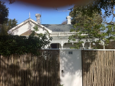
Photograph - 40 Guildford Road, Surrey Hills, The Street Where You Live Project
Photos documenting this address as part of a photographic series undertaken by volunteer photographers during 2013 and 2014 for The Street Where You Live Project. This was organised through the Surrey Hills Neighbourhood Centre and covered the postcode 3127 in the cities of Boroondara and Whitehorse.These photos provide a snapshot of real estate in the suburbs of Mont Albert and Surrey Hills during a period of rapid change with many properties on large blocks demolished to create higher density residential development or renewal of single dwellings. At particular risk were properties not covered by heritage overlays, especially interwar housing and post 1950's housing. -
 Surrey Hills Historical Society Collection
Photograph - 41 Guildford Road, Surrey Hills, The Street Where You Live Project
Photos documenting this address as part of a photographic series undertaken by volunteer photographers during 2013 and 2014 for The Street Where You Live Project. This was organised through the Surrey Hills Neighbourhood Centre and covered the postcode 3127 in the cities of Boroondara and Whitehorse.These photos provide a snapshot of real estate in the suburbs of Mont Albert and Surrey Hills during a period of rapid change with many properties on large blocks demolished to create higher density residential development or renewal of single dwellings. At particular risk were properties not covered by heritage overlays, especially interwar housing and post 1950's housing.