Showing 1964 items matching " bourke"
-
 Eltham District Historical Society Inc
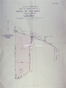
Slide - Photograph, Eltham Shire Council, Plan of Subdivision, Part of Crown Portion 3, Parish of Nillumbik, County of Bourke, 1969
35mm colour positive transparency blue Agfacolour Service plastic mountC5C, Delbridge, 4 lots, Rattray Road, 4 August 1969infrastructure, map, montmorency, planning, rattray road, subdivison lots, reichelt avenue -
 Eltham District Historical Society Inc
Slide - Photograph, Eltham Shire Council, Plan of Subdivision, Part of Crown Portion 3, Parish of Nillumbik, County of Bourke, 1969
35mm colour positive transparency blue Agfacolour Service plastic mountB3 Robinson prelim subdivision, View Road, 4 August 1969infrastructure, map, planning, subdivison lots, rattray road -
 Mission to Seafarers Victoria
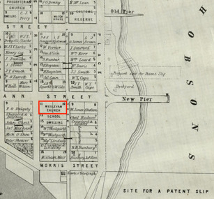
Map, Surveyor General's Office, Plan of Williamstown, County of Bourke, 20 November 1855
Plan of Williamstown in 1855The map helps locate the Wesleyan church on Ann Street which was converted in the Sailors' Rest in 1875.ann street, wesleyan church, sailors' rest, williamstown -
 Koroit & District Historical Society
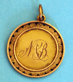
Warrnambool and District Farmers(?) Association Life Membership Medallion, Warrnambool and District Farmers(?) Association Life Membership Medallion Martin Bourke 1922, 1922
warrnambool, district, farmers, medallion, martin bourke, 1922, medal, life, membership -
 Koroit & District Historical Society
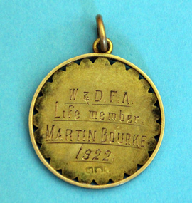
Warrnambool and District Farmers(?) Association Life Membership Medallion Martin Bourke 1922, Martin Bourke 1922
martin bourke, 1922, warrnambool, farmers, medal, life, membership -
 Greensborough Historical Society
Map, Keelbundora. Counties of Bourke and Evelyn, 1950_11
Covers area bounded by Merri Creek, Yarra River, Plenty River and Crown Portions 24 to 28, with section including Maroondah Aqueduct and Darebin Creek.Photocopy of digitised mapkeelbundora (parish) -
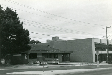
 Ringwood and District Historical Society
Photograph, Kenlaurel Dance Studio, Corner Bourke and Ringwood Street, Ringwood - 1973. Formerly Winnington Private School
Written on backing sheet, "Dancing Studio 1973. Formerly Winnington Private School, corner Ringwood Street". -
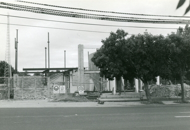 Ringwood and District Historical Society
Photographs, Rebuilding the Ringwood Police Station corner of Ringwood and Bourke Sts in 1996
-
 Ringwood and District Historical Society
Photographs, Kenlaurel Dance Studio being demolished in 1996, corner of Ringwood and Bourke Sts Ringwood
-
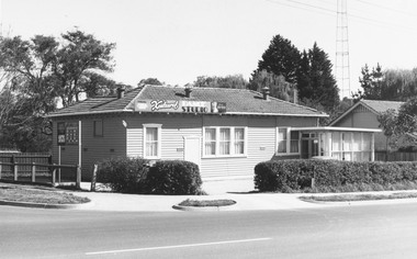
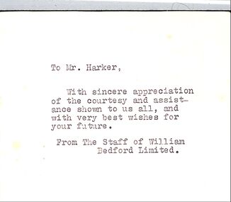 Ringwood and District Historical Society
Memorabilia, Card from the Staff of William Bedford Ltd.on Archir Harkers leaving. and a Bill from Davis Tailoring Bourke St. Melbourne for a suit 15-2-1936
Part of the collection of memorabilia of Ruby and Archie Harker . Related to the Wieland's of heathmomt through the marriage of Ruby's sister to Stan Wieland! Small bifold card with type written message and signatures inside. 2. Bill for suit for mr. J.A. Harker.Dated 15-2-1936 -
 Whitehorse Historical Society Inc.
Map, Nunawading. County of Bourke, 1878
Photocopy of map of Shire of Nunawading.Photocopy of map of Shire of Nunawading. Note: Fosters v President of the Shire of Nunawading. On Verso: Copied from the most up to date by the Dept of Lands, 1878. Laid before the Executive Council, 11 June 1878. Shows land holders.Photocopy of map of Shire of Nunawading.shire of nunawading, maps -
Whitehorse Historical Society Inc.
Map, Directory Maps of the County of Bourke, 1892
Copies of Directory maps:(i) Title Page, (ii) Preface (iii) Heading section of Map of Melbourne and Suburbs (iv) Parish of Bulleen - includes 'North - East portion of the Parish of Nunawading (v) Village of Burwood. Note: 107(a), 107(b), 107(c) are copies of the same set of sheets.Copies of:(i) Title Page, (ii) Preface (iii) Heading section of Map of Melbourne and Suburbs (iv) Parish of Bulleen - includes 'North - East portion of the Parish of Nunawading (v) Village of Burwood. Note: 107(a), 107(b), 107(c) are copies of the same set of sheets.Copies of Directory maps:(i) Title Page, (ii) Preface (iii) Heading section of Map of Melbourne and Suburbs (iv) Parish of Bulleen - includes 'North - East portion of the Parish of Nunawading (v) Village of Burwood. Note: 107(a), 107(b), 107(c) are copies of the same set of sheets.maps, parish of bulleen, parish of nunawading, burwood -
Rutherglen Historical Society
School Records - Individuals, Higher Elementary School, Rutherglen, Bourke, Kenneth John, 1952
From School records, some more complete than others. Reports should contain information on the pupil's school work and give details of what they did when they left school. They should also show the name of a parent and the occupation. All sheets are indexed on a spreadsheet at the Common School Museum.Individual school records of the pupils of the Higher Elementary School, Rutherglen, 421 in all.pupils, students, rutherglen higher elementary school, school reports -
Rutherglen Historical Society
School Records - Individuals, Higher Elementary School, Rutherglen, Bourke, Frances (Fay), 1951
From School records, some more complete than others. Reports should contain information on the pupil's school work and give details of what they did when they left school. They should also show the name of a parent and the occupation. All sheets are indexed on a spreadsheet at the Common School Museum.Individual school records of the pupils of the Higher Elementary School, Rutherglen.pupils, students, rutherglen higher elementary school, school reports -
 Kingston Arts
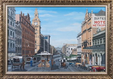
Painting, Graeme Hardiman, Bourke Street, April,1993
-
 Department of Health and Human Services
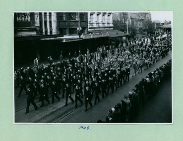
Air Cadets, Girl Guides and Catholic groups in between Flinders and Bourke Streets marching towards the Melbourne Town Hall on Swanston Street, Melbourne CBD Australia, from the War Memorial 1949 - Department of Health – National Fitness Office (Sports & Recreation) – Historical Press Release Photo Collection
Department of Health – National Fitness Office (Sports & Recreation) – Historical Press Release Photo - Empire Youth Day & Royals on Tour CollectionDepartment of Health – National Fitness Office (Sports & Recreation) – Historical Press Release Photo - Empire Youth Day & Royals on Tour Collection -
 Department of Health and Human Services
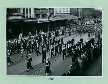
Sea and Army Cadets in between Flinders and Bourke Streets marching towards the Melbourne Town Hall on Swanston Street, Melbourne CBD Australia, from the War Memorial 1949 - Department of Health – National Fitness Office (Sports & Recreation) – Historical Press Release Photo Collection
Department of Health – National Fitness Office (Sports & Recreation) – Historical Press Release Photo - Empire Youth Day & Royals on Tour CollectionDepartment of Health – National Fitness Office (Sports & Recreation) – Historical Press Release Photo - Empire Youth Day & Royals on Tour Collection -
 Department of Health and Human Services
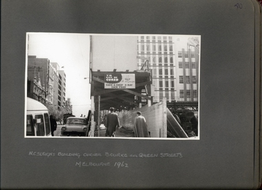
Photograph, Anti Tuberculosis Campaign - "TB Can Be Cured" "Be sure you're free" "Have a Chest X-Ray Each Year - Billboard & Signage at H C Sleigh's Building Corner of Bourke & Queen Sts 1962 - Department of Health - Tuberculosis Branch - Chest X-Ray Surveys program
Photo from Accession AS/14/612 -
 Department of Health and Human Services
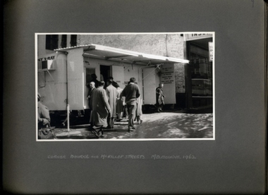
Photograph, Anti Tuberculosis Campaign - People queuing and exiting X-ray caravan on a wet day on the Corner of Bourke & McKillop Streets Melbourne 1962 - Department of Health - Tuberculosis Branch - Chest X-Ray Surveys program
Photo from Accession AS/14/612 -
 Bayside Gallery - Bayside City Council Art & Heritage Collection
Map, Department of Crown Lands and Survey et al, Moorabbin, County of Bourke, Government Roads, 1920
The cadastral map of the Parish of Moorabbin in Victoria (L.6104) shows parish boundaries and land ownership 1920 when Sandringham was a Town. The government roads have been coloured in red pencil.moorabbin, county of bourke, map, plan, land subdivision, land titles, foreshores, hampton, beaumaris, highett, cheltenham, department of lands and survey, land owners, cartographic material, brighton, sandringham, town of sandringham, government roads -
 Bayside Gallery - Bayside City Council Art & Heritage Collection
Map, Department of Crown Lands and Survey, Moorabbin, County of Bourke, c. 1918
The cadastral map of the Parish of Moorabbin in Victoria (L.6104) shows parish boundaries and land ownership c. 1918 when Sandringham was a Borough.moorabbin, county of bourke, map, plan, land subdivision, land titles, foreshores, sndringham, hampton, beaumaris, highett, cheltenham, department of lands and survey, land owners, cartographic material, borough of sandringham, brighton -
 Kew Historical Society Inc
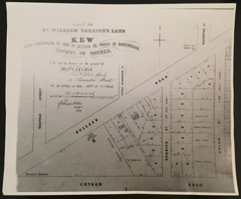
Print - Subdivision Plan, F Price, Plan of Mr William Derrick's Land, Kew being Subdivision of Part of Section 86, Parish of Boroondara, County of Bourke, 1872, 1872 [Original]
This work forms part of the collection assembled by the historian Dorothy Rogers, that was donated to the Kew Historical Society by her son John Rogers in 2015. The manuscripts, photographs, maps, and documents were sourced by her from both family and local collections or produced as references for her print publications. Many were directly used by Rogers in writing ‘Lovely Old Homes of Kew’ (1961) and 'A History of Kew' (1973), or the numerous articles on local history that she produced for suburban newspapers. Most of the photographs in the collection include detailed annotations in her hand.The Rogers Collection provides a comprehensive insight into the working habits of a historian in the 1960s and 1970s. Together it forms the largest privately-donated collection within the archives of the Kew Historical Society.A photographic reproduction of a plan in the Vale Collection of the State Library of Victoria showing William Derricks land in the area bordered by Bulleen Road (High Street); Cotham Road and Union Street. The plan dates from 1872.william derrick, subdivision plans -- kew (vic.) -
 Kew Historical Society Inc
Plan - Subdivision Plan, Plan of Subdivision of Part of Crown Portion 84 / Parish of Boroondara / County of Bourke / Lodged Plan No. 2217, Twentieth Century
Pru Sanderson, in her groundbreaking ‘City of Kew Urban Conservation Study : Volume 2 - Development History’ (1988), summarised the periods of urban development and subdivisions of land in Kew. The periods that she identified included 1845-1880, 1880-1893, 1893-1921, 1921-1933, 1933-1943, and Post-War Development. These periods were selected as they represented periods of rapid growth or decline in urban development. An obvious starting point for Sanderson’s groupings involved population growth and the associated economic cycles. These cycles also highlighted urban expansion onto land that was predominantly rural, although in other cases it represented the decline and breakup of large estates. A number of the plans in the Kew Historical Society’s collection can also be found in other collections, such as those of the State Library of Victoria and the Boroondara Library Service. A number are however unique to the collection.The Kew Historical Society collection includes almost 100 subdivision plans pertaining to suburbs of the City of Melbourne. Most of these are of Kew, Kew East or Studley Park, although a smaller number are plans of Camberwell, Deepdene, Balwyn and Hawthorn. It is believed that the majority of the plans were gifted to the Society by persons connected with the real estate firm - J. R. Mathers and McMillan, 136 Cotham Road, Kew. The Plans in the collection are rarely in pristine form, being working plans on which the agent would write notes and record lots sold and the prices of these. The subdivision plans are historically significant examples of the growth of urban Melbourne from the beginning of the 20th Century up until the 1980s. A number of the plans are double-sided and often include a photograph on the reverse. A number of the latter are by noted photographers such as J.E. Barnes.Undated Plan of Subdivision of Crown Portion 84 in what is now Kew. The area shown is bordered by Burke Road, Harp Road, Arglye Road and Normanby Road.subdivision plans -- kew (vic), harp road, burke road, normanby road, lady loch's drive, gladstone street, second avenue, first avenue -
 University of Melbourne, Burnley Campus Archives
Plan, Burnley Gardens. City of Richmond. Parish of Jika Jika - County of Bourke, 1927
Part-coloured plan showing drainage, sewerage drains, taps and waterstops. Area bounded by Swan St. To N, Yarra River on E and Richmond Park on SW side. Contour lines of orchard depicted, laying pens and yards. Coloured area depicts pavilion with surrounding garden and paths layout pencilled in. Photo-Lithograph by Dept. of Lands & Survey, Melbourne by W. Butsonsewerage, drainage, lithograph, pavilion -
University of Melbourne, Burnley Campus Archives
Plan, Burnley Gardens. City of Richmond. Parish of Jika Jika - County of Bourke, 1927
Plan showing Burnley Gardens - bounded by Swan St to N, Yarra River to E, Richmond Park on S and W side. Photo-lithographed at Dept. of Lands & Survey by W.J. Butson. Plan shows old orchard, fowl sheds, coops and yards, milking shed, silo, nursery, glasshouse, fattening pens, dairy, garden, orchards area in S.W. area.burnley gardens, orchards, sheds, nursery -
University of Melbourne, Burnley Campus Archives
Plan, Burnley Gardens. City of Richmond. Parish of Jika Jika - County of Bourke, 1927
Plan showing Burnley Gardens - bounded by Swan St to N, Yarra River to E, Richmond Park on S and W side. Photo-lithographed at Dept of Lands & Survey by W.J. Butson. Plan shows old orchard, fowl sheds, coops and yards, milking shed, silo,nursery, glasshouse, fattening pens, gardens and orchards area in S.W. corner.burnley gardens, orchards, sheds, nursery -
 Carlton Football Club
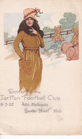
Menu for Dinner, Dinner to the Carlton Football Club 13/7/25 Hotel Metropole Bourke Street Melb, 1925
Mid Season Dinner Carlton Football Club 1925Era of mid season club dinners, toasting the King & various groups of Carlton FC notable. Some comments next to each dish humour of the day.Small Menu -
 Melton City Libraries
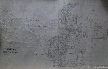
Map, Coimadai County of Bourke, 1911
Town Plan of Meltoncouncil -
Charlton RSL Sub Branch
Print - Framed print of troops marching, Framed print of Australian troops marching down Bourke Street Melbourne
Framed picture under glassTroops march through the city. A stirring spectacle on Friday. First Australian troops left Melbourne Sept. 1914 -
 Bacchus Marsh & District Historical Society
Map, Village allotments, Parish of Myrniong, County of Bourke
Myrniong is a village 9 kilometers west of Bacchus Marsh. Prior to 1863 the area was known as Blow's Flat. This map which was produced in 1903 and according to the catalogue record of this map held at the State Library of Victoria was based on an earlier map created in 1861. The early layout of streets for the village of Myrniong can be seen on this map. The streets shown are, Main Street, Hardy Street, Blow Street, Myrniong Street, Shuter Street, and Blackwood Street. An area marked as a reserve for a school can be seen between Hardy Street and Main Street.A single page paper map. A cadastral parish map of Myrniong in Victoria, showing numbered land allotments. Photo-lithographed at the Department of Lands & Survey, Melbourne, in 1903. Based on an original map created in 1861. The map is pasted into a bound volume containing 76 maps or plans in total. High resolution digital image stored on BMDHS computer network. Surveyed by John Hardy, Surveyor ; photo-lithographed at the Department of Lands & Survey, Melbourne by T.F. McGauran, 24.12.03myrniong parish plan, myrniong parish maps