Showing 3431 items
matching distances
-
 Lakes Entrance Historical Society
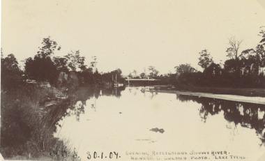
Postcard - Snowy River bridge, H D Bulmer Lake Tyers, Orbost Victoria, 1905 c
Black and white postcard taken of Snowy River with bridge in distance at Orbost VictoriaEvening Reflections Snowy Riverwaterways, bridges, rivers -
 Lakes Entrance Historical Society
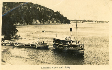
Postcard - Kalimna Jetty, 1925 c
Second copy enlarged, black and white 16 x 25 cmBlack and white postcard showing S S Gippsland leaving Kalimna Jetty, Jemmys point in background, hummocks in distance, several people on jetty, small boat in distance, man on rocks fishing. Lakes Entrance VictoriaKalimna Cove and Jettyships and shipping, waterways -
 Southern Sherbrooke Historical Society Inc.
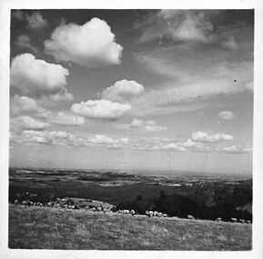
Photograph, Looking south from Black Hill Road Menzies Creek
Black and White photograph shows in the middle distance a flock of sheep belonging to Bill Hermon, south of the Breen farm in Menzies Creek. The land then falls away and flatter land fades away into the distance. There are fluffy clouds in the sky. -
 Mt Dandenong & District Historical Society Inc.
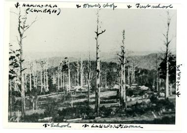
Photograph
Iconic photograph taken by Edgar Dower on Ridge Road in 1913 from an area known as Point Clear that shows the buildings of early Mt Dandenong before the CRB road went through in the 1920s.Black and white photograph with tall, dead trees in foreground and a view of hills in the distance. Buildings can be seen across the centre of the photograph. There are handwritten annotations around the border with arrows referring to areas in the photograph. Reverse of photograph has handwritten description by John Lundy-Clarke.Front from top left: Namoora (Lumeah), Dower's Shop, First school, Talent's, Langford's house, School. Reverse: 1913 view from O'Halloran's LOT 4, Section 3 on Ridge Road. Showing Lumeah (Namoora) Farndons Road (fence) School, Lowes House?, Falls Road Shop (Dowers) Langford's Falls Road (LOT 9, Section 1) Shed on Colomb's LOT 19, Sect 2 Colomb's House (Fergusons) First school Campbell's Blythes Road Lil Badenhop's P.O. In middle distance - Talent's homestead and sheds.point clear, namoora, lumeah, langford, dower, talent, colomb, ferguson, campbell, farndons road, mt dandenong school -
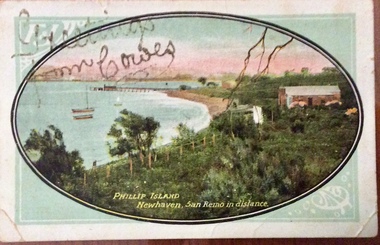 Phillip Island and District Historical Society Inc.
Photograph - Post Card, Newhaven postcard, About 1910
Postcard from Lizzie to Mrs Harry West " Moncrieff Bank", Cowes. 'Wishing you all A happy and Prosperous New Year 1910. Your loving cousin, Lizzie'Coloured postcard showing coastline, bay, jetty and buildings at Newhaven. Looking towards San RemoPhillip Island Newhaven, San Remo in the distance. Greetings from Cowes written in gold glitternewhaven, jetty, newhaven, photographs, postcards, moncrieff bank, harry west -
 Tatura Irrigation & Wartime Camps Museum
Photograph, Goulburn Weir, 1890
Taken by photographer for State Rivers and Water Supply Commission.Medium sized black and white photograph. Earthworks foreground, horse and dray lower right, men working on concrete weir structures, middle distance, - river with tree'd banks beyond, workmen's huts and house left of middle distancevictoria state rivers and water supply commission, goulburn weir -
 Bendigo Military Museum
Photograph - RASvy Surveyors in the field, c1950s – 1960s
This is a set of 1photographs of surveyors in the field measuring distances using chains, taking observations using theodolites and operating electric distance measurement equipment. They were probably employed in establishing mapping and geodetic control operations or the surveyors may have been in training. The photos were most likely taken in the 1950s and 1960s. Photos .1P to .6P feature personnel setting up geodetic survey chaining equipment to measure distances. The surveyor in Photo .5P is LTCOL Howard Angus Johnson MBE who served from 1936 to 1954. The RA Svy surveyor in photos .7P to .12P were using a theodolite to take angular measurements. They were usually supported by an observer who recording their readings on a booking form. The surveyor in Photo .10P and .11P is LTCOL Jorge Gruszka, who served from 1955 to 1985. He was CO of the Army Survey Regiment from 1982 to 1985. The surveyor in photo .13P is cutting an identification blaze on a tree using a hammer and chisel. The tellurometer in Photos .14P to .16P was a MRA1 microwave Electronic Distance Measuring instrument (EDM) introduced in 1958. It and later models were man-portable systems that improved geodetic survey efficiencies for rapid network extension and densification replacing triangulation with EDM and theodolite traverse sometimes using Bilby Towers to extend line lengths. The surveyor with the slouch hat is Colonel James ‘Jim’ Leslie Stedman, who served from 1941 to 1978. He was Director of Military Survey from 1975 to 1978 and was appointed as Colonel Commandant (honorary appointment, Retd) of the Royal Australian Survey Corps from 1978 to 1983. Jim Stedman is demonstrating EDM equipment.This is a set of 17 photographs of surveyors in the field measuring distances using chains, taking observations using theodolites and operating electric distance measurement (EDM) equipment. c1950s – 1960s. The photographs were printed on photographic paper and are part of the Army Survey Regiment’s Collection. The photographs were scanned at 300 dpi. .1) - Photo, black & white, c1950s, unidentified personnel using geodetic survey chaining equipment. .2) to .4) - Photo, black & white, c1950s, geodetic survey chaining equipment. .5) – Photo, black & white, c1950s, Jim Stedman using geodetic survey chaining equipment to measure distances. .6) - Photo, black & white, c1950s, Unidentified personnel geodetic survey chaining equipment. .7) – Photo, black & white, mounted on card, c1950s. Unidentified surveyor undertaking observations on a coral reef using a theodolite. .8) – Photo, black & white, c1950, unidentified surveyor undertaking observations with a Tavistock theodolite. .9) – Photo, black & white, mounted on green card, c1950s. Unidentified surveyor undertaking observations using a plane table. .10) – Photo, black & white, c1955, Jorge Gruszka undertaking observations with a theodolite. 7/55 Basic Survey Course Balcombe. .11) – Photo, black & white, c1950s, Jorge Gruszka undertaking observations with a theodolite. .12) – Photo, black & white, c1946-1948, unidentified surveyor undertaking observations with a theodolite to gain control for the mapping of the Snowy Mountain Diversion Scheme. .13) – Photo, black & white, c1950s, unidentified surveyor cutting a blaze in a tree. .14) and .15) – Photo, black & white, c1960s, Jim Stedman demonstrating EDM equipment. .16) – Photo, black & white, c1960s, L to R: Jim Stedman (probably) and unidentified surveyor demonstrating EDM equipment. .17) – Photo, black & white, 1956, Operation Cutlass - Surveyors SPR W. Crane and J.A. Campbell undertaking observations with a theodolite in extreme conditions..1P on back - First Order Chaining Equipment .2P on back - First Order Chaining Equipment .3P on back - Full catenary 1800 – 1960 replaced by EDM .4P on back - First Order Chaining Equipment .5P on back - H.A. Johnson, Benambra baseline? 1st Order Chaining .6P on back - Chaining .7P on front - Difficult observing conditions especially when the tide is in. The station is sighted (sic) on a coral reef. .8P on back - Tavistock. .10P on back of duplicate in Photo Folder 14 – George (sic) Gruszka 7/55 Basic Survey Course Balcomme (sic) 1955/56 .14P and .15P on back - Jim Stedman demonstrating early EDM equipment.royal australian survey corps, rasvy, army survey regiment, army svy regt, fortuna, asr, surveying -
Glenelg Shire Council Cultural Collection
Negative - Negative - Nelson Victoria, Glenelg River in background, c. 1936
Transparency for black and white photo. Nelson Victoria, Glenelg River in background, ocean in distance. -
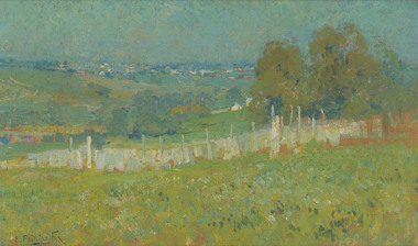 Benalla Art Gallery
Painting, E. Phillips FOX, From Charterisville, c. 1900
Born: Fitzroy, Victoria, Australia 1865; Died: 1915ImpressionismLedger Gift, 1993Rural landscape with fence and buildings in the distance. Gold gesso on decorative wood moulding frame.Recto: Signed "E. Phillips Fox" in black paint l.l.c of composition; Not dated; Not titledlandscape, buildings, rural, hills, fence, australian art -
Tatura Irrigation & Wartime Camps Museum
Photograph - copy, Original May 1945, copy 1989
WW2 internment camp 1 hospitalTwo A.A.N.S. sisters in front of galvanized iron huts. Garden beds mid distance.a.a.n.s., camp 1, internee camp, camp hospitals -
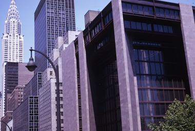 Robin Boyd Foundation
Slide, Robin Boyd, 1969
Robin Boyd travelled to the USA and Britain for several weeks. He attended the opening of the new Australian Chancery in Washington DC, where he had designed an innovative exhibition with cylindrical display cases and sound recordings.Colour slide in a mount. Crysler building in the distance, New York, New York, USAMade in Australia / 7 / JUL69M2 / Encircled 20 (Handwritten)slide, robin boyd -
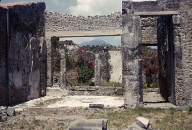 Robin Boyd Foundation
Slide, Robin Boyd, 1950
Penleigh Boyd, Robin and Patricia Boyd's son, writes “Prior to 1950 Robin, like most other amateur or hobby photographers, took black and white printed photographs. The oldest slides date from 1950 when Robin and Patricia travelled to Europe on Robin’s Robert Haddon Travelling Scholarship.” In 1948 Robin Boyd was awarded ‘joint first place’ in the Robert Haddon competition for his design of Mildura art gallery. The scholarship helped fund their first overseas trip. Robin and Patricia were passengers on the Greek ship “Cyrenia” departing in May 1950, passing through the Suez Canal and landing in Genoa five weeks later. For six months, they travelled extensively throughout Europe (predominantly driving themselves) - France, Italy, United Kingdom, Sweden, Denmark, Germany, Austria, Switzerland and Spain.Colour slide in a mount. Ancient Roman house with oleanders and Vesuvius in the distance, Pompeii, ItalyPompeii / House / With Vesuvius & Oleandors (All Handwritten)haddon travelling scholarship, haddon, robin boyd, slide -
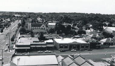
 Stawell Historical Society Inc
Photograph, Gold Reef Mall -- Main Street Stawell 2003
Gold Reef Mall Main Street 2003Colour Photograph: Looking West from near victoria Place, truck in mid distance.stawell business -
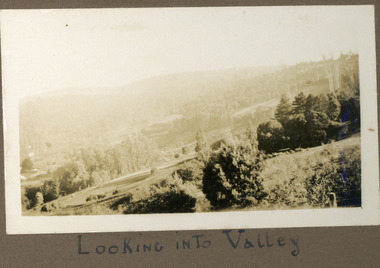 Mt Dandenong & District Historical Society Inc.
Photograph
The photograph is from the album of Ivy Child. The scene is looking across the Kalorama Valley with land cultivated by the Jeeves family. Ivy May Child (1910 – 1989) was the daughter of Arthur Edward (Ted) Child (1878 – 1964) and Ethel May Madden (1888 – 1970). Ted Child was the son of Matthew Francis Child (1839 – 1933) and Martha Jeeves (1857 – 1926). He was the grandson of one of the early pioneers Francis Child. Ivy grew up on the family property on Childs Road and took many photographs. Most of these are glued into her photo album. The album covered the years from c1927 – 1932. Ivy married Henry William Burgess (1906 – 1968) in 1944. The photographs remain in their original state in the album with individual copies made. Black and white photograph with bushes in the foreground, hills in the distance and a cleared, cultivated area in the centre.Below the photograph in the album" LOOKING INTO THE VALLEYkalorama, kalorama valley, jeeves, valley -
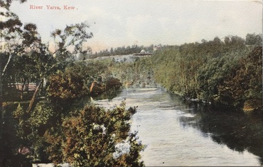 Kew Historical Society Inc
Postcard, River Yarra, Kew, 1918-1930
The Kew Historical Society's postcard collection includes views of Kew, Melbourne and Greater Melbourne as well as those including overseas scenes sent or received from Europe or the Middle East. They date from the 1890s to the 2000s. These postcards may or may not include the name of the publisher or printer. A number of the cards were published as parts of popular series. A way of dating early postcards is to identify whether the reverse was divided by a central line which became the norm after 1902 in the United Kingdom. However, other postcards produced after this date do not always conform to this print layout.The item forms part of the Laurie Bennett collection of thirty-six postcards and photographs of Kew and early Melbourne, donated to the Kew Historical Society in 1980. The postcards in the Bennett collection, like other images in the Society's holdings date from the 1890s to the present and comprehensively indicate points-of-view or scenes considered historically, aesthetically or socially significant in the period in which they were produced.Colour-tinted postcard of the River Yarra at Kew, showing the Kew Lunatic Asylum in the distance.KH-395 .Donated by L. Bennett, 1980river yarra - kew -
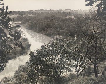 Kew Historical Society Inc
Photograph, J E & B L Rogers, View of Yarra from Cliffs, Studley Park, 1958
This work forms part of the collection assembled by the historian Dorothy Rogers, that was donated to the Kew Historical Society by her son John Rogers in 2015. The manuscripts, photographs, maps, and documents were sourced by her from both family and local collections or produced as references for her print publications. Many were directly used by Rogers in writing ‘Lovely Old Homes of Kew’ (1961) and 'A History of Kew' (1973), or the numerous articles on local history that she produced for suburban newspapers. Most of the photographs in the collection include detailed annotations in her hand.The Rogers Collection provides a comprehensive insight into the working habits of a historian in the 1960s and 1970s. Together it forms the largest privately-donated collection within the archives of the Kew Historical Society.Back and white photograph of the Yarra River at Kew. In the distance the towers of the Kew Asylum are visible."View of Yarra from Cliffs, Studley Park" / "Studley Park" / "Jim's" / "58"yarra river -- kew (vic), landscape photography -
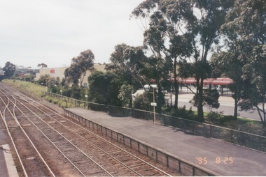 Sunbury Family History and Heritage Society Inc.
Photograph, 25th July 1995
The photograph of Sunbury Station was taken from the pedestrian bridge and is looking north to take in the Sunbury Square shopping centre buildings and the bus terminal which are on the Platform 1 or east side of the station.During the 1990s much development took place in Sunbury and the station precinct became a commercial hub.A coloured photograph of a railway station and a Coles Supermarket in the middle distance as well as a bus terminal. -
 Stawell Historical Society Inc
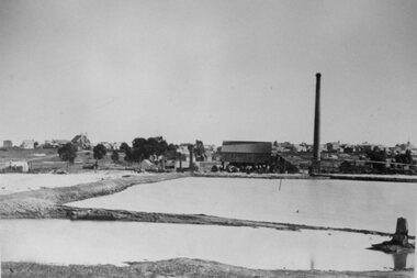
Photograph, Early St George Crushing Battery with dam in foreground. c1864
St. George Public Crushing Battery with dam in foreground. Erected in 1860 one of four public crushing batteries. Enlarged later in 1864 by new owners.Settling ponds in foreground crushing shed with chimney on right. Methodist Church in distance on leftmining -
 Stawell Historical Society Inc
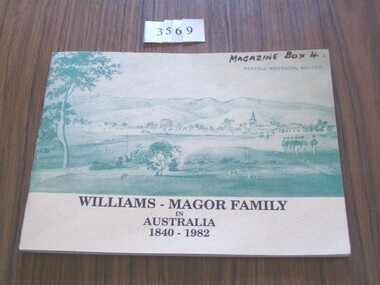
Book, Edna Deans, Williams - Magor Family in Australia 1840-1982, 1992
History of the Williams - Magor Family Cream Textured Card cover with green drawing featuring building in the distance and soldiers on the right.Williams - Magor Family in Australia 1840 - 1982stawell -
Port Melbourne Historical & Preservation Society
Photograph - Harold 'Dags' BROWN, Lagoon Reserve, Port Melbourne
Lasercopy of view of Harold 'Dags' BROWN in Lagoon Reserve C1945, Gasometers and building in distanceOn back "unknown lagoon Reserve" in pencil. Harold Brown (Dags) in inksport - australian rules football, harold 'dags' brown, lagoon reserve -
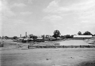 Stawell Historical Society Inc
Photograph, Magdala cum Moonlight Mine with two tailing dams c1900's. Same as 1386-13
Magdala cum Moonlight Mine c1900 Buildings include the mine managers office, change rooms, crushing battery, retorting room, blacksmith shop and cyanide vats. Fence advertises "Drink RoBur Tea"B/W Photo of Magdala Mine Works in middle distance with two tailing Dams. stawell gold mining -
 Lakes Entrance Historical Society
Postcard - Pyramid Rock Buchan Victoria, 1940 c
Black and white postcard showing the mountains in distance beyond the valley and township of Buchan Victoriafarming, topography, settlement -
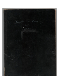 Melbourne Tram Museum
Book, H.S. McComb, "Lengths of Lines and Curves", c1930
Book - black covers - 4 sections sewn - 124 pages lined - titled "Lengths of Lines and Curves". Has an index. Gives details of junction layouts, distances, hand drawing layouts, route and track miles, tables of actual distances, average distance and figure on which mileage is worked. In the rear of the book are some hand written calculation notes. Not all pages imaged, just those with a diagram.On top of the cover of one copy in ink "pages 1, 4, 14,17, 23"trams, tramways, trackwork, mmtb, mileages -
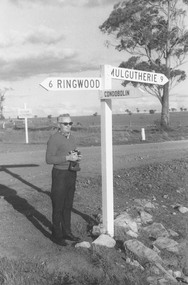 Ringwood and District Historical Society
Photograph, Hampshire, England. Road sign indicating distance to Ringwood. Undated
Catalogue card reads, "Hampshire, England. Road sign indicating distance to Ringwood". Man is unidentified. No date -
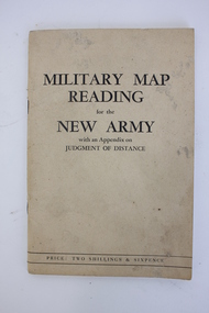 Dandenong/Cranbourne RSL Sub Branch
Booklet, Robertson & Mullens Ltd et al, Miltary Map Reading for the New Army with an Appendix on Judgment of Distance, 1941
Beige booklet bound with two staples. White pages within with black illustrations and type. 64 pages.Front: "MILITARY MAP / READING / for the / NEW ARMY / with an Appendix on / JUDGMENT OF DISTANCE / PRICE: TWO SHILLINGS & SIXPENCE"military map reading, orientation, navigation -
 Bendigo Historical Society Inc.
Photograph - AERIAL VIEW: BENDIGO, 1995
Black and white photo: aerial view from St. Paul's church tower showing Bush's store in foreground. St. Andrew's church middle distance, Myers St. at left front to middle distance. Williamson St. left to right foreground.Peter Hyettplace, aerial view of bendigo -
Tatura Irrigation & Wartime Camps Museum
Photograph, Goulburn Waranga Main Channel Construction, 1957
Photo taken by the photographer for Victoria State Rivers and Water Supply Commission of the Goulburn Waranga main channel in 1957.Large black and white photograph - dry mounted to cream board. Channel excavation scene - with excavator operating right mid distance, scoop bucket operating top of earth wall left mid distance, supervised by figure on top of earth wall.Below photo: "Goulburn Waranga Main Channel Construction / Bucyrus 200 W. Excavator with 6 c. yd. Bucket / Looking towards off-take at Goulburn Weir / Completed Excavation in Background."goulburn, waranga, irrigation, photo, victoria state rivers and water supply commission -
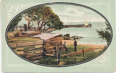 Phillip Island and District Historical Society Inc.
Photograph - Post Cards, Late 1800's
Six Postcards donated by Joyce Suto of MitchamSix colour postcards. 1. The hut was probably Mr Cox's. View to Jetty in background with two yachts moored. 2. View of the Cowes Jetty with Jetty Shed in foreground and the Steamer "Lady Loch" in the distance. 3. Surf breaking over the rocks at Phillip Island Back Beach. 4. Cape Woolamai cliffs and shoreline. 5. View of Cowes Jetty taken from a Steamer 6. Wool team and horse and buggy in the background on road to Cowes1. Phillip Island - Fisherman's Hut, Cowes. 2. Phillip Island - Cowes Jetty. Govt. Steamer "Lady Loch" in distance. 3. Phillip Island. Back Beach. 4. Phillip Island - Cape Woolamai. Home of Mutton Bird. 5. Phillip Island - Cowes from Steamer. 6. Phillip Island - Wool Team on road to Cowes.coastline cape woolamai, cowes jetty, fisherman's beach hut, mr cox beach hut, steamers, steamer lady loch, cowes pier phillip island, joyce suto -
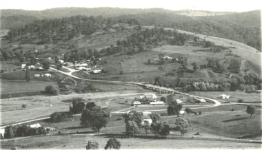
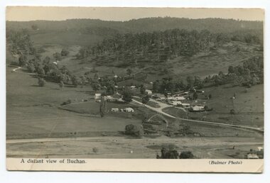 Orbost & District Historical Society
black and white photograph, Howard D. Bulmer, first half 20th century
This is a pictorial record of Buchan in the first half of the 20th century.A black / white photograph / postcard of a township in a valley. The photograph has been taken from a distance.on front - A Distant View of Buchanbuchan -
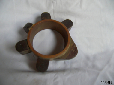 Flagstaff Hill Maritime Museum and Village
Pattern
Pattern-spider band wooden object round with six points at equal distance around edge. flagstaff hill, warrnambool, shipwrecked-coast, flagstaff-hill, flagstaff-hill-maritime-museum, maritime-museum, shipwreck-coast, flagstaff-hill-maritime-village