Showing 1938 items
matching floods
-
 Kew Historical Society Inc
Photograph - Flooding of the Yarra Valley at Kew East, 1974
... floods ...Flooding of the Yarra Valley, including that section of the Yarra bordering Kew and Kew East in the north and west of the municipality, was a regular occurrence. Extreme flood events of the Yarra River are recorded to have occurred in 1891, 1901, 1916, 1923 and 1934. The Municipality of Kew's response to these floods was to enact planning decisions restricting residential development in flood prone areas following the floods of 1916, 1921 and 1934. While floods continued after the development of the Upper Yarra Reservoir (construction 1948-57), the regularity and extent of these inundations diminished. During the nineteenth century, the land abutting the south side of the Yarra in Kew was devoted to dairy farming. In the twentieth century, before and after the construction of the Eastern Freeway, much of this low-lying area was used as golf courses and public parks.Late example of the capacity of the Yarra Valley at Kew to flood, even though drainage works and the Upper Yarra Reservoir had reduced their regularity.Original black and white print photograph of Hay's Paddock under floodwater on 16 May 1974. The vantage point of the photographer is Keystone Crescent looking east. Flooding was caused by overflowing water in Glass' Creek and the River Yarra. Annotation verso: "Keystone Cr looking east / 16 May 1974 11.50am"hays paddock, floods, yarra river, glass' creek -
 Kew Historical Society Inc
Photograph - Flooding of the Yarra Valley at Kew East, 1974
... floods ...Flooding of the Yarra Valley, including that section of the Yarra bordering Kew and Kew East in the north and west of the municipality, was a regular occurrence. Extreme flood events of the Yarra River are recorded to have occurred in 1891, 1901, 1916, 1923 and 1934. The Municipality of Kew's response to these floods was to enact planning decisions restricting residential development in flood prone areas following the floods of 1916, 1921 and 1934. While floods continued after the development of the Upper Yarra Reservoir (construction 1948-57), the regularity and extent of these inundations diminished. During the nineteenth century, the land abutting the south side of the Yarra in Kew was devoted to dairy farming. In the twentieth century, before and after the construction of the Eastern Freeway, much of this low-lying area was used as golf courses and public parks.Late example of the capacity of the Yarra Valley at Kew to flood, even though drainage works and the Upper Yarra Reservoir had reduced their regularity.Original black and white print photograph of the low-lying land at East Kew under floodwater on 16 May 1974. The vantage point of the photographer is Lister Street. Flooding was caused by overflowing water in Glass' Creek and the River Yarra. Annotation verso: "Lister St looking same as No.3 / 16 May 1974 11.30"floods, yarra river, glass' creek, lister street -
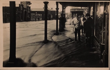 Kew Historical Society Inc
Postcard - Flood, Glenferrie Road, Hawthorn, 1921
An item from an outstanding and diverse photographic collection, assembled by members of the Christian and Washfold families of Kew.Flood waters in Glenferrie Road. Shopkeeper and bystanders on pavement. Real photo postcard produced by Kodak, probably to a photo by Henry Christian. "Dec 1921 / Floods in Glenferrie Rd"glenferrie road -- hawthorn, floods -- hawthorn (vic.), christian-washfold collection -
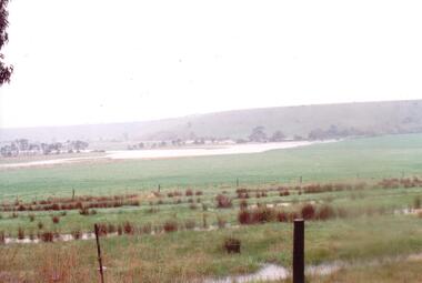 Hume City Civic Collection
Photograph
... floods ...The series of photographs were taken after exceptional heavy rain had fallen in Sunbury in the early 1990s. The Jackson Creek overflowed its banks and the surrounding flood plain area was under water.A coloured photograph of the Jackson Creek in flood along a river flat within the Rupertswood Estate. There are bare hills in the background and a fenced off run in the foreground.floods, weather patterns, jacksons creek, george evans collection -
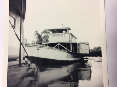 Port of Echuca
Black and white square photograph, 1974
This photograph shows the height of the river in the 1974 floods. The fence on top of the wharf can be seen the other side of the Pevensey. The height of the river can also be seen on the N.S.W bank. This photograph is significant because it shows the height of the river in the 1974 floods.This is a small square black and white photograph of the P.S Pevensey tied up to the Echuca wharf in the 1974 floods. The P.S Canberra is tied up in front of the Pevensey. A very small portion of the Canberra can be seen. On the front of the photograph the words Pevensey can be seen. On the back of the photograph hand written in ink are the words" Pevensey 1974 floods. Beside wharf. Canberra in foreground."1974 floods, flooding, p.s.pevensey, echuca wharf -
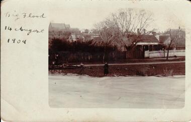 Hume City Civic Collection
Photograph, 14/08/1909
... floods ...The Jackson Creek flooded on 14 August 1909 when the creek was 32 feet above sea level.A sepia photograph of Powlett Street in the big flood of 1909. Unmounted postcardjackson's creek, powlett street, sunbury, floods, gregor, bob, billinghurst, beryl, francey, sandra, alex, our lady of mt carmel church, churches, 1909, george evans collection -
 Hume City Civic Collection
Photograph, 14/08/1909
... floods ...The Jackson Creek flooded on 14 August 1909 when the creek was 32 feet above sea level.A sepia photograph of the Jackson Creek in flood. Goonawarra winery is in the background. Unmounted postcardjackson's creek, goonawarra farm, sunbury, floods, gregor, bob, billinghurst, beryl, francey, sandra, alex, bridges, macedon street bridge, george evans collection -
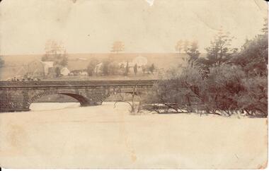
 Kew Historical Society Inc
Photograph - Country road
Original, black and white positive print which the inscription on the reverse incorrectly claims is of Kew during the 1934 floods. The date may be 1934, but there is no evidence of flood waters or of location. The photo is of an intersection with a hotel on the corner in front of which a man is standing. The hotel would appear to be named Russell['s] Hotel. There is also an advertisement for Willys on the hotel verandah. Inscribed verso: "Yarra Floods Kew 1934" unidentified locations -
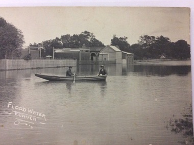
 Port of Echuca
A black and white postcard, 1906. or. 1916
... floods ...The postcard is significant because it shows the extent of the flood in the early 20th Century. The bridge crosses the Southern Cross channel which had been built as part of the Murray Darling irrigation system. There is a vehicle on the bridge either being towed by bullocks or horses. Floodwaters cover the whole view.The postcard is significant because it shows the extent of the flood in the early 20th Century. The bridge crosses the Southern Cross channel which had been built as part of the Murray Darling irrigation system. It is also near the water filtration plant which filters the town's water supply. There is a vehicle on the bridge either being towed by bullocks or horses. Floodwaters cover the whole view.A black and white postcard showing Goulburn Road, Echuca East, in either the 1906, or 1916 floods.Printed on the back are the words; W. Grimwood Echuca. POST CARD. Correspondence Address Only Kodak Australia. Hand written on the back are the words 1906 or 1916? Southern Cross bridge near filtration plant. Goulburn Road, Echuca East.floods, goulburn road, echuca east, pullicino, j, postcard, southern cross channel, water filtration plant -
 University of Melbourne, Burnley Campus Archives
Photograph - Black and white print, 6/18, 1947
... floods ...Lagoon Paddock flooded. lagoon paddock, floods, e. m. gibson collection -
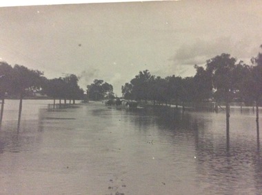
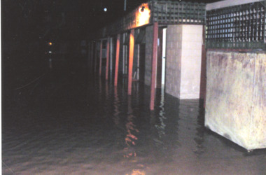 Lakes Entrance Historical Society
Photograph - Floods 1998 Lakes Entrance Victoria, Main Caravan Park, 2007 c
... Floods ...Colour photograph taken outside flooded buildings at Main Caravan Park Lakes Entrance Victoria. Also another colour photograph showing flooding inside toilet block at Main Caravan Parkfloods -
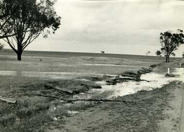
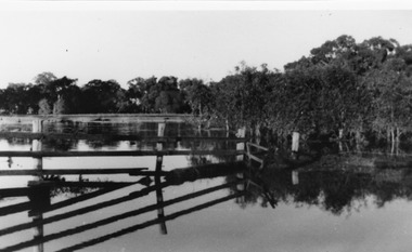
 Kew Historical Society Inc
Photograph - Flooding of the Yarra Valley at Kew East, 1974
... floods ...Flooding of the Yarra Valley, including that section of the Yarra bordering Kew and Kew East in the north and west of the municipality, was a regular occurrence. Extreme flood events of the Yarra River are recorded to have occurred in 1891, 1901, 1916, 1923 and 1934. The Municipality of Kew's response to these floods was to enact planning decisions restricting residential development in flood prone areas following the floods of 1916, 1921 and 1934. While floods continued after the development of the Upper Yarra Reservoir (construction 1948-57), the regularity and extent of these inundations diminished. During the nineteenth century, the land abutting the south side of the Yarra in Kew was devoted to dairy farming. In the twentieth century, before and after the construction of the Eastern Freeway, much of this low-lying area was used as golf courses and public parks.Late example of the capacity of the Yarra Valley at Kew to flood, even though drainage works and the Upper Yarra Reservoir had reduced their regularity.Original black and white print photograph of the low-lying land at East Kew under floodwater on 16 May 1974. The vantage point of the photographer is Lister Street. In the photo, the fences of the Kilby Farm can be seen. Flooding was caused by overflowing water in Glass' Creek and the River Yarra. Annotation verso: "Hay's Paddock op No.30 Lister Street / 16 May 1974 11.50am / R.L. 46.04"hays paddock, floods, yarra river, glass' creek, lister street -
 Charlton Golden Grains Museum Inc
Photograph, Charlton Tribune, Flood Water damage to McGurk's fence, c. 1980
Flood 1971, damage to Mc Gurk's fencing on Calder Highway.B/W photo of flood water & damage to McGurk's fence on Calder Highway in 1971 flood.flood, calder highway, charlton -
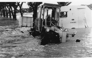 Charlton Golden Grains Museum Inc
Photograph, Cameron, Ian, c.1973
CRB grader towing a caravan 1973 Flood - washed off road before Yeungroon turnoff in 1973 flood.B/W photograph CRB grader towing a caravan 1973 Flood - washed off road before Yeungroon turnoff in 1973 floodflood, calder highway, yeungroon -
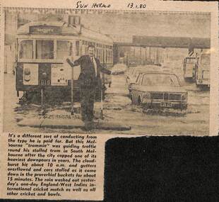 Melbourne Tram Museum
Newspaper, Herald Sun, Newspaper clipping re flooding in South Melbourne, 13-1-1980
... floods ...Newspaper cutting about flooding in South Melbourne disabling a tram and a "trammie" conductor or driver, directing traffic. Tram W7 1019, route 10.Yields information about the type of delays that can occur on a big tram system.Newspaper cutting from the Herald Sun 13-1-1980 about flooding in South Melbourne and delaying tram W7 1019"Sun Herald 13.1.80"trams, tramways, tramcars, flooding, floods, south melbourne, w7 1019, route 10, crews -
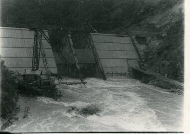 Kiewa Valley Historical Society
Photograph - Kiewa River in flood at Clover Dam
As part of the push to cut electricity costs and diversify supply, the Victorian Government (circa 1930) implemented the conversion strategy from mainly brown coal supply to hydro - electricity. The Kiewa Hydroelectric Scheme became the largest scheme of its kind in the State Of Victoria and the second largest scheme in Australia. Clover Dam and Power Station were built by the State Electricity Commission of Victoria as part of the Kiewa Hydro Electric Scheme from the late 1930's to the early 1940's. This dam was constructed to supply water to feed four turbines (62 mega watts) at the West Kiewa Power Station. This was at the forefront of sustainable "Green" energy. Costs associated with power supplies is still a major incentive of governments, however environmentally friendly alternatives such as wind and nuclear have also made inroads. The Kiewa valley and its surrounding alpine catchment were looked at(Victorian State Government), from the beginning of the twentieth century as a source of alternate power for an ever-increasing demand for electricity by growing population and heavy industrial areas within Melbourne City and State regions. Construction of dams, such as Clover Dam provided the large quantity holding areas of water required to turn the turbines at the various power stations to provide the electricity needed. The impact of these controls by moderating water run-off from the alpine regions is beneficial in reducing flooding from thawing of snow on the alps. This by-product allows agriculture and grazing to be less vulnerable to seasonal flooding thereby resulting in a more stable annual production level.Black and white photograph of Clover Dam with Kiewa River in flood. .5mm white boarder on 3 sides of photo.Handwritten on back of photograph in black pen - Kiewa in flood. Clover Dam.clover dam, secv -
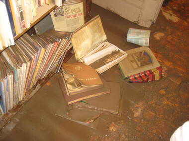 Ballarat Heritage Services
Photograph - Colour, Bookcase, Flood Recovery, Carisbrook
... floods ...Colour photograph of the muddy remains after the Carisbrook Flood.carisbrook, floods -
University of Melbourne, Burnley Campus Archives
Photograph - Black and white print, Series 6.18
... floods ...Series 6Lagoon Paddock flooded.lagoon paddock, floods, james leslie provan, j.l. provan -
 Bendigo Historical Society Inc.
Newspaper - LYDIA CHANCELLOR COLLECTION: MAJOR T. FLOOD SPEAKS
A small black cardboard box with a red rose on the lid containing newspaper clippings of Cr. Tom Flood's column from 'The Bendigo Advertiser titled, 'Mayor Speaks.' 1966,67.Mayor T. Flood Speaks 1966, 1967newspaper, bendigo advertiser, major speaks, lydia chancellor, collection, newspaper, mayor t. flood, cr. flood, 'mayor speaks, ' 'the bendigo advertiser, ' bendigo -
 Port of Echuca
A black and white photographic postcard, Between 08/1906 - 10/1906
Photographic Postcards were very popular in the early 20th century and this shows the Campaspe river, Echuca in flood. The high water mark is exemplified by having the rower on the water. The water has inundated the surrounding bush with trees partly submerged along the right hand side of the photograph.Rowing clubs were popular in towns along the Murray river and this picturesque scene of the Campaspe river , Echuca in flood shows a man rowing a racing scull down the river.Black and white photographic postcard showing the Campaspe river, Echuca, in flood, with a man rowing a racing scull.On face : "Campaspe River, Echuca". On reverse: printed in ink :" Post Card. This space may be used for correspondence. For address only. Place penny stamp here." In pencil is written: "Aug Sep Oct 1906 Flood" "Donation H V Evans 85 Fullers Rd Chatswood NSW." " Echuca Regional Library" is stamped but has been crossed out in pen.campaspe river, echuca, echuca flood, 1906, rowing, echuca -
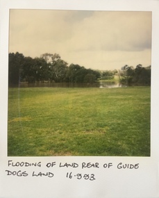 Kew Historical Society Inc
Photograph - Flooding at parkland at rear of Guide Dogs Victoria, 1993
The land currently occupied by Guide Dogs Victoria was once part of the grounds of the Kew Lunatic Asylum. This includes the land, designated as parkland which adjoins the Yarra River. It is now designated as the Chandler Park.Original colour small format polaroid photograph of flooding in parkland at the rear of Guide Dogs Victoria in the area now used as the Main Yarra Trail; taken on 16 September 1993."Flooding of land rear of Guide Dogs land 16.9.93"yarra river -- floods -- kew (vic.), guide dogs victoria, main yarra trail, chandler park -
 Charlton Golden Grains Museum Inc
Photograph
Flooded Billabong Cadgow's Dairy in the bend of the Avoca River Oct 1975Black and white photograph of flooded billabong.flood, charlton -
 Port of Echuca
Black and white postcard, Early 20th Century
The gasworks in Anstruther St, allowed the streets of Echuca to be lit at night, therefore improving the safety of the citizens of the town. The gasworks were operational for many year providing cooking and lighting facilities to houses as well as to the streets. This picture shows the height of the flood in either 1906 or 1916? The Senior Citizens Club now stands on the site. The Central Kindergarten and Echuca Primary School are also nearby.This postcard is significant because it shows the height of the floods before the town levee banks had been built. It also shows the need for flood proofing the town. It also shows the size of the gasworks in the early 20th Century. The Senior Citizens Club is currently built on this site.A rectangular black and white postcard showing the gasworks in Anstruther Street, during a high flood, in either 1906 or 1916. The gasworks site is now the site of the Senior Citizens Club. A picket fence surrounds the gasworks and there are two men rowing a row boat passed the works in the flood water.On the front of the postcard in white hand writing are written the words 'Flood Water - Echuca.' On the back of the postcard the following words are printed. "W.Grimwood. Echuca. POST CARD. Correspondence. Address Only. Kodak Australia." Handwritten in pen are the words "Old Gasworks Anstruther Street. Now site Senior Citizens Club" Handwritten in pencil are the words "1906 or 1916"echuca gasworks., anstruther street, flooding, 1916, 1906, street lights, pullicino, j -
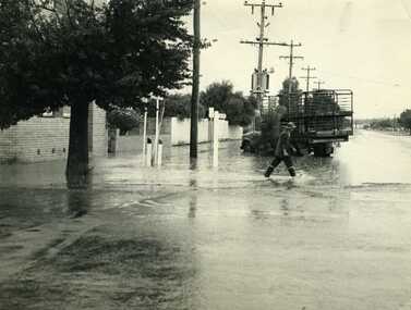 Charlton Golden Grains Museum Inc
Photograph, Cameron, Ian, 1972 Flash Flood, Jan 1972
1972 Flash flood, cnr of High St and Armstrong St, Charlton.B/W photograph of 1972 flash flood Corner High Street & Armstrong Streets. Man crossing road through flood water.flood, charlton, armstrong street -
 University of Melbourne, Burnley Campus Archives
Photograph - Black and white print, Helen Dudley, View Towards Boulevard, 1944-1945
Black and white photograph. View towards Boulevard from the drive. Lagoon paddock is flooded. On reverse, "1944-1945 shot from driveway Paddock looking to Boulevard area often flooded in those days."boulevard, helen dudley, 1991, centenary, lagoon paddock, flooding -
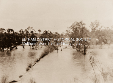 Eltham District Historical Society Inc
Photograph, Diamond Creek in flood 1924, 1924
... floods ...Colour reproduction copy of an original sepia photograph of Diamond Creek in flood 1924diamond creek, floods -
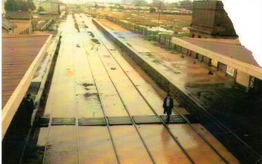 Sunbury Family History and Heritage Society Inc.
Photograph, 17th December 1985
On the afternoon of the 17th December 1985 torrential rain fell in Sunbury and surrounding areas which resulted in widespread flooding and caused disruption on the main Melbourne Bendigo Railway line. The photograph looking towards the south shows the extent of the flooding at Sunbury Station.A coloured photograph of a railway station and the flooded tracks.sunbury railway station -
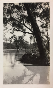 Kew Historical Society Inc
Photograph - Flood, Zig-Zag, Kew, 1924
Henry Beater Christian (1886-1962) , was a descendant of one of the earliest settler families in Kew. Employed at the Kew Asylum as a 'public servant', he was a skilled amateur photographer, photographing numerous scenes in Kew and on his travels around Victoria. The majority of his photographs date from 1916 to 1929. His finest photographs are housed in two photograph albums. Digital copy of a photograph from page 5 of the 47-page photograph album containing 261 gelatinous silver images, loaned by Diane Washfold with permission given to digitise and hold a copy in our collection. This is a photograph of the river at Kew during a flood in January 1924."Flood / Zig-Zag Kew / 1.24"henry beater christian (1886-1962), landscape photography, kew (vic.) — yarra river, christian-washfold collection, photograph albums, floods -- yarra river -- kew (vic.) -
Clunes Museum
Photograph
COPY OF PHOTOGRAPH OF FLOOD ON CRESWICK CREEK AT GOVERNMENT BRIDGE12/9/1909 FROM CLUNES TALBOT RD. MOTHER WRITING TO AMY. CLUNES JUBILEE BRIDGE DURING THE SEVERE FLOOD, WHEN AT ITS HIGHEST MARK. IT REMINDED ME OF SEA WAVES. THE WATER WAS AT OUR FEET AS WE STOOD WATCHING IT IN MRS BARKELL'S COW YARD. MRS BARKELL AND MARY WHITE (THE WRITER) TOOK IT IN TURNS TO COOK DINNER AND WATCH THE FLOODflood 1909, mrs a white, flood creswick creek -
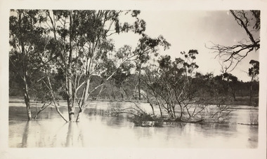 Kew Historical Society Inc
Photograph - Flood, Zig-Zag, Kew, 1924
Henry Beater Christian (1886-1962) , was a descendant of one of the earliest settler families in Kew. Employed at the Kew Asylum as a 'public servant', he was a skilled amateur photographer, photographing numerous scenes in Kew and on his travels around Victoria. The majority of his photographs date from 1916 to 1929. His finest photographs are housed in two photograph albums. Digital copy of a photograph from page 5 of the 47-page photograph album containing 261 gelatinous silver images, loaned by Diane Washfold with permission given to digitise and hold a copy in our collection. This is a photograph of a section of the river at Kew during a flood in January 1924."Flood / Zig-Zag Kew / 1.24"henry beater christian (1886-1962), landscape photography, kew (vic.) — yarra river, christian-washfold collection, photograph albums, floods -- yarra river -- kew (vic.)