Showing 173 items
matching land division
-
 Bendigo Historical Society Inc.
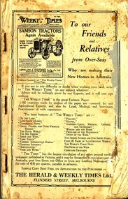
Book - ERROL BOVAIRD COLLECTION: NEW SETTLERS' HANDBOOK TO VICTORIA
Book titled 'New Settlers' Handbook to Victoria. Book contains information of the State of Victoria, Welcoming the New Australian, The Farm Learner, Settling on the Land, The Settler's Home, The 'N.S.L.' Districts and a Buyers' and Sellers' Directory.New Settlers League of Australia3john bovaird collection - new settlers' handbook to victoria, the herald & weekly times ltd, the honorable john allan mla, new settlers league of australia (victorian division), archibald gilchrist -
 Bendigo Historical Society Inc.
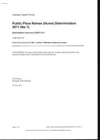
Document - PUBLIC PLACE NAMES (HUME) DETERMINATION 2011, 20 July 2011
Document, Public Place Names (Hume) Determination 2011 (No1) PPN Act 1989. I Determine the names of the public places that are Territory land as specified in the attached schedule and as indicated on the associated plan, Signed John Meyer, Delegate of the Minister 20 July 2011. Pethard Road in Hume was approved on 08 August 2011. Many thanks to Kay MacGregor for her help in the research of the Pethard Family Page 4 Pethard Family Research, Page 5 Division of Hume where Pethard Road is situated. Included is a map showing Pethard Road coloured In .Authorised by the ACT Parliamentary Counsel.document, names of bendigo pioneers, george pethard -
 Monbulk RSL Sub Branch
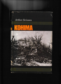
Book, Cassell, Kohima, 1966
On 7 March 1944 Tokyo announced that the Japanese invasion of British India had begun. By mid-month, the Japanese 31st Division had crossed the Chindwin River in northern Burma, advancing on a wide front towards Imphal and Kohima. In bitter jungle fighting from early April, the British Fourteenth Army under Field Marshal Slim held the Japanese assault on Kohima Ridge. By late June the Japanese were in headlong retreat. Kohima ranks for strategic importance with Alamein, Midway and Stalingrad. The increasing dominance of Allied airpower in the region in the aftermath of the battle was a major factor.Index, bibliography, ill, maps, p.275.non-fictionOn 7 March 1944 Tokyo announced that the Japanese invasion of British India had begun. By mid-month, the Japanese 31st Division had crossed the Chindwin River in northern Burma, advancing on a wide front towards Imphal and Kohima. In bitter jungle fighting from early April, the British Fourteenth Army under Field Marshal Slim held the Japanese assault on Kohima Ridge. By late June the Japanese were in headlong retreat. Kohima ranks for strategic importance with Alamein, Midway and Stalingrad. The increasing dominance of Allied airpower in the region in the aftermath of the battle was a major factor. kohima - siege - 1944, world war 1939-1945 - land operations - india -
 Bendigo Historical Society Inc.
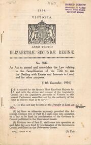
Book - 1954 VICTORIA ANNO TERTIO ELIZABETHÆ SECUNDÆ REGINÆ NO. 5842, 17/8/56
A small book owned by Accountant & Auditor Harold Curnow detailing the "Simplification of Title to and the Dealing with Estates and Interests in land for for other purposes", it also has the date 17/8/56 written in pencil on the top left corner. The first page is written as following. "17/8/56 Harold Curnow Accountant & Auditor Colonial Mutual Building View Point, Bendigo 1954 VICTORIA ANNO TERTIO ELIZABETHÆ SECUNDÆ REGINÆ No. 5842. An Act to amend and colidate the law relating to the Simplification of the title to and the Dealing with Estates and interests in Land and for other purposes. [14th December, 1954.] Be it enacted by the Queen's most Execellent Majesty by and with the advice and consent of the Legislative Council and the Legislative Assembly of Victoria in this present Parliament assembled and by the authority of the same as follows (that is to say) 1. (1) this Act may be cited as the Transfer of Land Act 1954. (Short title commencement and division) (2) (a) Save as otherwise ecpressly provided this act (except Division two of Part II.) shall come into operation on a day to be fixed by proclamation of the Governor in Council published in the Goverment Gazette. (b) Division two of Part II. shall come into operation on such later day as is fixed by proclamation of the Governor in Council published in the Goverment Gazette 6325/55 -Price 3s. 9d. (3) This"victoria -
 Bendigo Historical Society Inc.
Book - 1958 VICTORIA ANNO TERTIO ELIZABETHÆ SECUNDÆ REGINÆ NO. 6284, 23/2/60
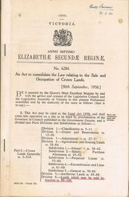
A small book owned by Accountant & Auditor Harold Curnow dated 23/2/60 detailing "An Act to consolidate the Law relating to the Sale and Occupation of Crown Lands." on page 61 it also has a 2/10/61 newspaper article and a June 27, 1962 page from the Victoria Gazette both of them detailing the Laws. The first page is written as following "Harold Curnow 1958. VICTORIA ANNO SEPTIMO ELIZABETHÆ SECUNDÆ REGINÆ No. 6284. An Act to consolidate the Law relating to the Sale and Occupation of Crown Lands, [30th September, 1958.] Be it enacted by the Queen's Most Execellent Majesty by and with the advice and consent of the legislative Assembly of Victoria in this present Parliament assmled and by the authority of the same as follows (that is to say) 1. This act may be cited as the Land Act 1958. and shall come into operation on a day to be fixed by proclamation of the Governor in council published in the Goverment Gazette, and is divided into Parts Divisions and Subdivisions as Follows:-"victoria -
 Bendigo Historical Society Inc.
Book - RESIDENCE AREAS REGISTER - VOLUME 20, 1925 - 1928
Document: RESIDENCE AREAS REGISTER - Volume 20. Large register bound in green with red spine and corners. Contains 202 paper pages listing residence licenses, Sandhurst Division, Bendigo District 10 July 1925 to 20 July 1928. Index in front. On spine 'Register of residence areas' '20'place, bendigo, residence areas, bendigo, sandhurst, residence areas, land sales -
 Bendigo Historical Society Inc.
Document - RESIDENCE AREAS REGISTER SANDHURST: VOLUME 19
Register: Residence Areas Register Sandhurst : : Volume 19, faded maroon hard cover, spine bound in darker maroon. Contains paper pages nos. 1 - 802 with entries of registration details of residence areas, Sandhurst district, Sandhurst division. Index is not entered. Separate index to Volume 19. Date from February 4 1914 to July 6 1925.place, bendigo, residence areas, bendigo, sandhurst, land sales, residence areas, register -
 Tatura Irrigation & Wartime Camps Museum
Poster, Tatura Subdivision, 1928
Hogans Estate was privately owned land on Tatura's north side as opposed tot he government sub division when Tatura was founded.Large Tatura subdivision poster of 1928 advertising large area north of Hogan Street, named Hogan Estate. Clear plan of subdivisions. Bold print in red and blue.Great subdivision sale. Hogans Estate Tatura. Saturday 18 August 1928. J. McNamara & Co.tatura subdivision, hogans estate -
 Victorian Aboriginal Corporation for Languages
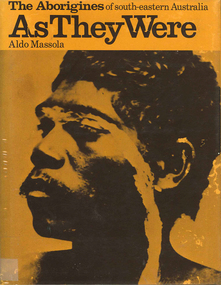
Book, Aldo Massola, The Aborigines of south-eastern Australia : as they were, 1971
Contents: p.1-3; Origins, arrival in Australia; p.4-9; How they lived - camp sites, dating (including carbon dating); p.10-27; Physical appearance, skin colour, hair, clothing, body ornaments, cicatrization; exchange system, distribution of food, marriage &? sexual relations; the tribe - structure, relationship to land, territory, gives map showing locations of tribes, New South Wales, Victoria &? eastern South Australia, leadership, government, division of labour, status of women, estimated population at white settlement, density of population (Victoria); p.28-31; Language - names &? naming, reproduces Wembawemba vocabulary, notes use of secret languages, gives 12 rules for pronounciation; p.32-53; Religion, spirit beliefs, totemism, moieties, phratries, marriage rules; mythology, gives eaglehawk &? crow myth from Lake Victoria &? other myths illustrating origins of fire &? natural rock formations, mythical beasts (Bunyip, Mindie), stellar beliefs; magic, medicine men, powers, native remedies for sickness, describes ceremony held in Melbourne, 1847 to avert evil, sorcery, pointing bone, love magic, rain makers; messengers, appearance, etiquette, message sticks; p.54-71; Rock art, motifs, colours, decorative art, engraving of utensils, rock engravings, manufacture &? use of pigments, engraving techniques; trade system, objects bartered, meeting places for trade (Victoria), map shows possible routes (south east Australia); corroborees, purpose, body ornaments &? decorations, musical instruments; p.72-93; Ceremonial life, marriage, punishment for infidelity, birth, childhood, games &? amusements, initiation, etiquette of visiting tribes, details of ceremony, womens role, earth figures &? ground designs, bull roarers, female puberty ceremonies; p.94-133; Shelters, fire making, cooking, construction of canoes, wooden implements, use of reeds, animal skins &? sinews, shells; stone tools, cylindro conical stones, scrapers, knives &? microliths; hunting weapons, spear, other methods pits, nets; fishing methods &? spears, traps; food sharing, womens responsibilities for collecting, digging stick, cooking methods, insect foods, plant foods, water resources; manufacture &? use of spears, spear throwers, shields, clubs, boomerangs; inter- &? intratribal fighting; p.134-147; Death, disposal of body - eating of the dead, burial, cremation, platform exposure, dendroglyphs (N.S.W.), Aboriginal burial grounds (Darling &? Murray Rivers), mourning, widowhood, kopi caps (N.S.W.), causes of death, inquest ceremonies, revenge expedition, after death beliefs; p.148-157; The end of the tribes white settlement &? its impact on Aboriginal life, friction between natives &? settlers, establishment of Protectorates; copiously illustrated throughout.maps, b&w illustrations, b&w photographswemba wemba, murray river, darling river, lake victoria -
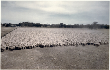 National Wool Museum
Photograph, Puckapunyal - 75,172 Sheep for Shearing, 1988
Banjo Paterson once wrote, ‘The musterers are fetching them a hundred thousand strong’. Well, not quite 100,000 strong, but there are 75,172 mixed age Riverina-bred merino wethers in this mob mustered for shearing on January 22, 1988. The sheep were owned by the Mountjoy family from Geelong Victoria and were running on Puckapunyal Army Base near Seymour in Central Victoria on which the family held the grazing lease. Contractor for the shearing, Jim Walker, Avenel, Victoria, former Australian shearing team captain in 1974-75 and 1978-79, recalls there were up to 21 shearers in his team waiting for the red eyes to arrive despite the mid-summer heat of up to 38°C and the blinding dust on windy days. Jim Walker thinks there may also have been some sheep in the mob from Portland Downs and Isis Downs near Isisford in Central Queensland. The biggest shearing he did at ‘Pucka’ was 87,087 shorn in 1988. The ‘Pucka’ base was established during WW1. During the Second World War the Second Australian Imperial Force trained there as well as the US Army 41st Infantry Division. It was also home to the 1st Armoured Regiment from 1949 until 1995. During the 1950s up to 4000 national servicemen at any given time were training there. In the 1980s the Army undertook a major 60,000-acre land rehabilitation programme as decades of heavy use had led to serious degradation. By 1988 when the photo was taken, further land acquisition had increased the area to just under 100,000 acres, 43,000 of which is still bush country. There are no sheep there now, and the old shed was bulldozed and burnt. There are thousands of kangaroos which of course don’t need to be shorn and would be hard to muster and hold for a similar photo. Colour photograph, 75,172 merino wethers, mustered for shearing at Puckapunyal in 1988.shearing merino sheep, mountjoy, mr dale - worungalla pastoral co., shearing, merino sheep -
Whitehorse Historical Society Inc.
Document, Division of Survey and Mapping, 1984
Information guide to Parish and Township Plans - Division of Survey and Mapping - Victorian Government..Information guide to Parish and Township Plans - Division of Survey and Mapping - Victorian Government..Information guide to Parish and Township Plans - Division of Survey and Mapping - Victorian Government..crown lands, victorian government, land surveys -
Whitehorse Historical Society Inc.
Document, Division of Survey and Mapping, 1984
A brief guide to Crown Lands And Survey records commonly used for family history research.A brief guide to Crown Lands And Survey records commonly used for family history research.A brief guide to Crown Lands And Survey records commonly used for family history research.crown lands, victorian government, land surveys -
 Whitehorse Historical Society Inc.
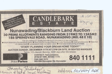
Document, Candlebark Estate, 27/07/1994 12:00:00 AM
Advertisement of auction of 'Candlebark Estate'.Advertisement of auction of 'Candlebark Estate'. 30 allotments, 186 Springvale Road, Nunawading., 11 December 1994. Agents: Peter Parkes. Former site of 'Winlaton', division of Dept. of Social Welfare. In the Age Property Section 23 November 1994.Advertisement of auction of 'Candlebark Estate'. candlebark estate, nunawading, winlaton, springvale road, land subdivision -
 Whitehorse Historical Society Inc.
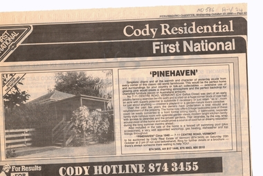
Newspaper, Pinehaven, 17/10/1990 12:00:00 AM
Advertisement for auction of 'Pinehaven' built circa 1940, 7 - 11 Centre Road, Vermont (cnr Gallus Close).Advertisement for auction of 'Pinehaven' built circa 1940, 7 - 11 Centre Road, Vermont (cnr Gallus Close). Land size 1/2 acre, sub-division potential.Advertisement for auction of 'Pinehaven' built circa 1940, 7 - 11 Centre Road, Vermont (cnr Gallus Close).pinehaven, centre road, vermont, nos 7-11, poultry, gallus close, cody first national real estate -
 8th/13th Victorian Mounted Rifles Regimental Collection
Photograph
The Dibb Report into mainland defence of Australia,1986, among other things identified the requirement for protection of key assets in Northern Australia and the possibility of involving Army Reserve (Ares) units in this thus releasing regular forces for offensive operations. Dibb also pointed out that this defined role would result in a huge lift in Ares morale. In June 1988, the 3rd Division (3Div) conducted a Tactical Exercise without Troops (TEWT), Exercise ‘Distant Trumpet’ in the Katherine- Darwin area to study problems associated with defence against low level incursions against Tindal RAAF Base. Exercise ‘Northern Explorer’ followed in October of that year when units of the 3Div including A Squadron 8/13 Victorian Mounted Rifles sent patrol groups to get a first taste of environment and conditions. Post-Exercise reports had to include recommendations re: health, equipment and adaptation of Standing Operating Procedures (SOPs) in preparation for the new role deploying to Northern Australia. The first deployment by 8/13 Victorian Mounted Rifles was in 1988. Deployments continued in following years. In September 1993, 3 Troop (Wangaratta) VMR Squadron 4/19 PWLH commanded by Captain Kelvin Robertson deployed to NT. The training began with airfield defence at Tindal followed by a 1000km recon into Arnhem Land in four Landrovers. The troop reported on the conditions of the roads, airfields, bridges (mainly causeways) resources such as fuel supplies in the towns and infrastructure. Each troop taking different route. 3 Troop had the Northern route through Kakadu National park across the East Alligator River to Oenpelli then to Maningrida and Ramangining and south to the Central Arnhem Road and back to Tindal Air force Base Major Annett later commanded 4/19 Prince of Wales's Light Horse, and later again 4th Brigade 2nd Division.. Colour photograph of Major M. Annett, Officer Commanding VMR Squadron 4/19Prince of Wales's Light Horse during annual exercise Northern Territory 1994. -
 8th/13th Victorian Mounted Rifles Regimental Collection
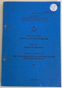
Book - Armour Training tank
Part of a serious of training pamphlets produced by the Australian Government c.1980Blue soft cover book " Australian Army Manual of Land Warfare Part two Armour Training. The Tank Regiment in support of the infantry division. "tank, armour, traininig -
 Southern Sherbrooke Historical Society Inc.
Information folder - Glen Park
... proposed division of Glen Park land. -Fax, dated 13 June 2000, from... proposed division of Glen Park land. -Fax, dated 13 June 2000, from ...Folder containing information pertaining to the history of Glen Park homestead, Menzies Creek. Contents: -two pages photocopied from "That Little Train" by Peter Cuffley, showing four photos of Glen Park homestead and a short history of Edwin Johns at Glen Park (2 copies of each) -articles, "No. 861's full steam ahead again", photo shows Col Rees with Coonara Community School students, and "Living the dream" re. engine no. 861. On verso, "A Family Reunited", article by Emerald Tourist Railway re. locomotives, and "Colin just loves steam locomotion" re. engine no. 861. -4 letters, from Puffing Billy Railway, in support of Col Rees. -Letter, dated 19 June 1996, from Emerald Tourist Railway, re. appeal for restoration of Garratt engine. On verso, copy of certificate awarded to Col Rees for donation to appeal. -Letter, 1 June 1998, re. Garrett appeal. On verso, certificate awarded to Col & Kellie Rees for donation to appeal. -Aerial photo showing proposed property boundaries of Glen Park subdivision. -Aerial photo showing existing property boundaries of Glen Park. NB. last four items provided to society by Col Rees in support of subdivision. -Memorandum dated 2 May 2000 from Graham Whitt, Shire of Yarra Ranges, to Shire Service Centres, re proposed division of Glen Park land. -Fax, dated 13 June 2000, from Southern Sherbrooke Historical Society to Shire of Yarra Ranges, re. intention to make submission. -Letter, dated 14 June 2000, acknowledging receipt of above fax. -Submission, dated 18 June 2000, from Southern Sherbrooke HS, expressing concern re. proposed subdivision of Glen Park. -Fax, dated 27 June 2000, from Dianne Kueffer to Susan Heywood-Downard, Agenda Item 2 of the Yarra Ranges Planning Committee Agenda 14 March 2000, including detailed description of proposed subdivision and map. -Letter, dated 7 July 2000, Shire to Society, re. discussion of Glen Park subdivision by council. -Letter, dated 7 July 2000, Society to Shire, re. withdrawal of objection subject to certain conditions. -Letter, dated 14 July 2000, Shire to Society, re. council resolution to allow subdivision of Glen Park. -Letter, dated 24 October 2000, Shire to Society, stating that amendment to Planning Scheme allowing subdivision was approved by council and gazetted on 19 October 2000. -seven A3 sheets, showing house and property plans for new constructions proposed for Lot 1 of Glen Park subdivision. -diagram, hand-drawn (by Col Rees?) on lined A4 sheet, showing proposed development. -A1 sheet, Plan of feature survey of Lot 2 Blackhill Rd, Selby, dated 12 April 2000, showing contours, vegetation, proposed location of buildings, etc. -Glen Park Homestead and Cyprus Avenue, document prepared for the Shire Of Yarra Ranges by Helen Lardner Conservation & Design P/L, June 2003edwin johns, breen family, col & kellie rees, puffing billy -
Southern Sherbrooke Historical Society Inc.
Information folder - Local Government Amalgamations 1986, 1985 & 1986
Folder containing information pertaining to the Local Government amalgamations in Victoria in 1986. Contents: -copy of "Local Government Act 1958, appointment of a division of the local government commission and referral of proposals to the division", 8 pages and 6 explanatory maps -memo, dated 21 November 1985 from K. E. Matson, General Manager, Shire of Sherbrooke, to all councillors, re. local government commission and municipal restructure, 12 pages including map -letter, Warwick Heine, CEO, Shire of Lilydale to K. E. Matson, General Manager, Shire of Sherbrooke, dated 16 April 1986, re. local government restructure (2 copies) -booklet, "The Restructure of Local Government in Victoria: Options Paper Eastern Melbourne Segment", Local Government Commission June 1986, 24 pages -article "Residents to fight land deal", Knox-Sherbrooke News, 17 June1986, re. proposed annexation of part of Lysterfield by Berwick Council -article "Knox and Sherbooke align for the future", The Trader, 30 April 1986, re. alignment of common boundary -article "Boundary changes 'just a joke'", by Cheryl Critchley, Knox-Sherbrooke News, 6 May 1986 , re. Knox-Sherbrooke boundary alignment -article "Border clash worsens", by Peter Janky, Mountain District Free Press, 7 May 1986, re. Sherbrooke-Lilydale boundary changes -article "Ranges future is still clouded", The Free Press 30 April 1986, re. proposal to form a shire covering Dandenong Ranges -article "Sherbrooke wins first battle in restructuring", by Peter Janky, Free Press, 30 April 1986, re. ceding of forest areas by Knox to Sherbrooke.shire of sherbrooke, shire of lilydale, knox city council, berwick shire council -
 Bendigo Historical Society Inc.
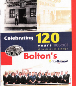
Booklet - Boltons Office National Celebrating 120 years of Business in Bendigo, 2005
Parry Collection History tells us that Benjamin Bolton and his two eldest sons, William and Arthur, began a printing business known as Bolton & Sons on March 25, 1885. But the Bolton name could just as easily have been erased from the annals of Bendigo during the treacherous sea journey that brought them from England in 1883. Benjamin, his wife and eight children (the youngest of whom was only three months old), boarded the “clipper” ship Ivanhoe on 17 July 1883 with little idea of what lay in store for them. Halfway through their 84-day journey, the Ivanhoe found itself in the midst of an equinoxial gale. For two days and nights, the ship was battered by huge seas and winds, while the Boltons and other passengers were battened down below deck with just a few candles and no fresh food or water. The ship and its passengers survived, but many of the crew were injured, and the ship was badly damaged. Having survived the gale, a week later, the Ivanhoe was hit with sleet, hail and snow, and the peril of icebergs. It must have been a great day for the Bolton family when Cape Otway appeared out of the fog, and the cry of “land ho!” echoed about the ship. The Bolton’s had arrived, and a Bendigo institution was about to be born. The location of the original printing business was in High Street but later moved to Williamson Street where the business underwent a name change to Bolton Bros and expanded into manufacturing paper bags and other stationery lines. In 1902, Bolton Bros moved to 43 Mitchell Street, which housed the retail stationery department and the main office, while the printing factory was on the second and third floors. Next door at 47 Mitchell Street, the wholesale division and machine service department operated. William and Arthur Bolton and their sons travelled throughout central and northern Victoria selling their own products and representing other companies. They are credited with being the innovators of the loose-leaf ledger. Today, of course, the business is back in Williamson Street with an even greater presence but the same entrepreneurial flair that has seen it survive and flourish through everything history has thrown at it. Having gone through five generations of family ownership, current company director-David Bolton, is proud of his company’s history and contribution to the local economy.Boltons Office National Celebrating 120 years of Business in Bendigo - 41 pages covering 1885-2005history, bendigo, merle lummis collection, boltons office national bendigo -
 Royal District Nursing Service (now known as Bolton Clarke)
Photograph - Digital image, 1931
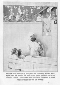
The Marion Boothby Ward in the 'MDNS After Care Home' opened in 1930 and was named in honour of Mrs Noel (Marion) Boothby, Life Governor and generous supporter of the Melbourne District Nursing Society who passed away in 1929. The photograph portrays a Trained nurse (Sister) holding a young child viewing the newly completed mural by Miss Jessie Traill. Two young children in a cane wicker trolley look on.Miss Jessie Traill 29/7/1881 - 15/5/1967 is today considered one of Australia's most remarkable printmakers. She studied painting and drawing at the National Gallery of Victoria. She spent over 3 years as a VAD nurse based in Rouen, France during World War 1. https://nga.gov.au/Traill/Chronology2.cfm The Melbourne District Nursing The Society (MDNS) were pioneers in recognizing the need for premises where patients too ill to be in their own home, but not ill enough to go to hospital, was needed. The MDNS had purchased its first premises, 'Floriston' at 39 Victoria Parade, Collingwood in 1914 and were able to purchase land next to No. 39, where the Society built the After-Care Home, it became No. 45 Victoria Parade, for these patients, and for patients from Hospitals. It was opened in July 1926 and the name of the Society then became ‘Melbourne District Nursing Society and After-Care Home’ (‘Hospital’ from 1934), Many children were nursed there, some long term during the Polio epidemic and two School Teachers were employed. The Society now ran two divisions, the After-Care with its own Sisters and nurses, and the District division which only employed Sisters. Black and white digital image of a Trained nurse (Sister) and 3 children in the Marion Boothby Ward in the Melbourne District Nursing Society After Care Home. The photograph portrays a Sister in her white uniform and white veil over her short curled hair. She is holding a young boy who has short dark hair, in her arms. He has a blanket around him. They are viewing the newly completed mural on the wall by Miss Jessie Traill. Two young girls, one with dark straight hair and the other with lighter coloured curled hair are sitting up together in a cane wicker trolley look up at the mural. The mural depicts flowers and children.melbourne district nursing society, after-care home, mdns, mrs noel (marion) boothby, miss jessie traill -
 Harcourt Valley Heritage & Tourist Centre
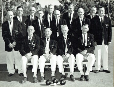
B & W photograph of fourteen men dressed in bowls club uniforms, Harcourt Bowling Club BDBA Pennant Winner Division 3 Season 1966-67, 1967
The inaugural meeting to form Harcourt Bowling Club was held in May 1955. Cr Ben Bingham donated half an acre of land in Bagshaw st Harcourt and the club acquired a small building from Blight's Quarry to serve as a clubhouse. The first day's play took place on 24th October 1959. New clubrooms were built in 1961 with the official opening of the Club held on Saturday 11th November 1961. The club became affilaited with Bendigo District Bowling Assocaition and, in 1966/67 won the Associated division 3 pennant. ; Depicts a group of men, the core ‘movers and shakers’ of the Harcourt community, in the course of their favourite recreation, Association champions in just the seventh year after formation.. Black and white photograph of fourteen men dressed in collar and tie, white trousers and dark blazers, each bearing the club name, HARCOURT BOWLING CLUB B.D.B.A. PENNANT WINNER - DIVISION 3- SEASON 1966-67 and the names of each player. -
 City of Kingston
Pamphlet - Colour, W. H. Wood Estate Agent, Realising sub-divisional auction sale Bentleigh Park Estate, Bentleigh, 1920
Sales plan for land in the suburb of Bentleigh, bounded by Centre Road, and incorporating subdivisions on either side of Elizabeth Street (Wheatley Road), Oak Street and Beech Street.The developing urban area of Bentleigh within the City of Kingston. This land sale pamphlet illustrates the subdivision of land within the municipality and the changing demographic of the district as new houses are constructed close to infrastructure.Colour pamphlet advertising a realising sub-divisional auction sale of the Bentleigh Park Estate, Bentleigh. Incorporates a map of the estate bordered by Centre Road, and including Elizabeth Street (Wheatley Road), Oak Street and Beech Street.Hand drawn in grey pencil: a small square on subdivision 33 Hand drawn in grey pencil: a small square incorporating a cross on subdivision 24 Hand written in black ink on reverse: Bentleigh Park / Estate / Ward late Andersonsland sales, estate, bentleigh -
 Sunbury Family History and Heritage Society Inc.
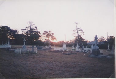
Photograph, Lydia Keyworth, Sunbury Cemetery, March 2001
The photograph of Sunbury Cemetery at sunset was entered into the Photograph Competition organised by the former Sunbury & District Heritage Association in March 2001.In 1862, land set aside in Cemetery Road for the Sunbury Cemetery was laid out in the following Christian denominational groups, Church of England, Roman Catholic, Baptist, Methodist, Presbyterian and Lutheran. Other non-denominational sites were set aside for paupers, heathens, Asians and pagans. Rebecca Jenkinson was the first person to be buried there in 1862. Over the years the size of the cemetery has expanded but it still occupies the original site off Shields Street in Sunbury and the names of the denominational divisions have changed over the years reflect a more inclusive outlook.Sunbury Cemetery replaced other smaller graveyards that were situated in some of the local church grounds and the earlier cemetery that was at The Gap township.A non-digital coloured photograph of a cemetery landscape with a number of old graves scattered across the open space. Some have small fences around them, while others simply display the headstones. There are trees in the background. sunbury cemetery, shields street, cemetery road, sunbury, cemeteries -
 Ringwood and District Historical Society
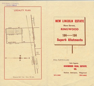
Document - Folder, Land Sale Brochure, New Lincoln Estate, Ringwood, Vic. - circa 1960. Also 1951 newspaper advertisement
Bi-fold advertisement for sale of residential allotments - New Lincoln Estate, New Street, Ringwood, with summary of local facilities and services, locality plan, layout of sub-division, and price list. Also an advertisement from Ringwood Mail dated 12 July 1951. Subdivision includes New Street, Heywood Street, Barkly Street, Keith Grove, Maurice Avenue, Inez Avenue, Catherine Street, Neville Street, Neale Grove (later Heather Grove), and Sylvia Grove. Agent - Ringwood Real Estate Co., Station Entrance, Ringwood. (Phone) WU 6661, WU 6662.Accompanying handwritten sales notes researched in 2024 by Richard Carter - Carter Real Estate ... "Maurice Ashkanasy KC CMG owned the rectangular estate located between New, Barkly, Heywood Streets and Sylvia Grove in South-West Ringwood. It was given the name "The New Lincoln Estate". It was first advertised around July 1951 as "48 superb allotments", through Ringwood Real Estate (Station Entrance). A sub-divisional plan from CE Carter showed 152 blocks with 60-foot frontages and varying between 110 and 150 feet in length. Later, in 1954 house and land packages were offered through William White in Elsternwick - "Three modern bedrooms, large lounge-dining-room, kitchen with dinette, nicely equipped bathroom - £2,685 to £2,762, deposit £300". The roads were created and named after family members - Neale (later Heather) Grove - after Maurice's son Neal Mark Ashkanasy. The street was later re-named Heather Grove after Maurice's wife, Heather Helen Ashkanasy (Epstein), who passed away in 1999, aged 95. Neville Street - after Marice's other son, Aaron Solomon Neville Ashkanasy known as Neville. Catherine Street and Inez Street - after Heather's mother Catherine Inez Epstein. Maurice Avenue - after Maurice Ashkanasy, vendor. Keith Grove - after Keith Epstein. ..." -
 Bendigo Historical Society Inc.
Document - RESIDENCE AREAS REGISTER: VOLUME 23, 1935 - 1936
Document: RESIDENCE AREAS REGISTER - Volume 23. Green hard covered book with buff spine and corners. 202 pages, with entries up to page 31. Bendigo District, Sandhurst Division. Dates 1935 - 1936.residence areas, bendigo, sandhurst, land sales -
 Bendigo Historical Society Inc.
Document - RESIDENCE AREAS REGISTER: VOLUME 22, 1932 - 1935
Document: RESIDENCE AREAS REGISTER - Volume 2. Green hardcover register with buff spine and corners. 202 pages listing residence areas, Bendigo district, Sandhurst division 3 May 1932 to 6 November 1935. Index contained in separate book. Correspondence enclosed inside book.bendigo, sandhurst, land sales, residence areas -
 Bendigo Military Museum
Photograph - RA Svy Project C4 Aerodist Operation, Eastern Arnhem Land, NT, 1967
This is a set of 30 photographs of Royal Australian Survey Corps (RA Svy) personnel from Central Comd Fd Svy Unit (Adelaide) on Aerodist survey operation - Project C4 in Eastern Arnhem Land, Northern Territory in 1967. Photos of personnel were taken either at the operations base at Numbulwar or the main base at Gove (Nhulunbuy). RA Svy conducted nineteen Aerodist operations for 12 years from 1964 to 1975. Aerodist MRC2 was a tellurometer-based system adapted for aircraft to accurately measure distances between non-intervisible ground survey stations, using the aircraft as an intermediate station. Lower order geodetic results could be achieved by survey network trilateration. The measured distances between stations formed survey networks from which each station’s latitude and longitude was computed. Aerodist MRC2 was RA Svy’s major horizontal control survey tool for mainly medium scale topographic mapping (scale 1:100,000 Class A being spatially accurate to within 50 metres) in PNG, northern NT, north-west WA, Kalimantan Barat (West) Indonesia, Sumatra Indonesia, Gulf of Carpentaria and Cape York, QLD. In 1967, the Aerodist MRC2 Master equipment was installed in the aircraft featured in this set of photos, Executive Air Services’ (Essendon VIC) Grand Aero Commander VH-EXX. It was the same aircraft type and company contracted to Division of National Mapping for Aerodist MRC2 surveys. From July to October 1967 the aircraft was attached to Central Comd Fd Svy Unit (Adelaide - Major Don Ridge) on Project C4 eastern-Arnhem Land NT, where 317 Aerodist lines measuring 17,300 line miles were successfully completed. This was the most productive Aerodist project thus far. The most common helicopter used by RA Svy up to 1972 was the civilian Bell 47G-2 and the Sioux Light Observation Helicopters (LOH), the Australian Army’s equivalent featured in this photo set. These light observation helicopters had a limiting load carrying capacity of up to about 500 pounds. By comparison, one Aerodist team including two people weighed up to 1,500 pounds. Source: Royal Australian Survey Corps – Aerodist Years 1964-1975 by Peter Jensen. This is a set of 30 photographs of Royal Australian Survey Corps (RA Svy) personnel on Aerodist survey operations in Eastern Arnhem Land, Northern Territory in 1967. The photographs are on 35mm negative film and scanned at 96 dpi. They are part of the Army Survey Regiment’s Collection. .1) to .4) - black & white, 20th August 1967, Project C4 Aerodist Operations Base - Numbulwar, NT. .5) - Photo, black & white, 1967. Probable wrecked Indonesian fishing vessel. .6) to .8) - Photo, black & white, 1967. Unidentified survey operations base, L to R: unidentified personnel. .9) - Photo, black & white, 1967. Unidentified survey operations base, unidentified soldier driving a Haflinger 4x4 Light utility vehicle. .10) - Photo, black & white, 1967. Unidentified survey operations base, L to R: unidentified technician. .11) - Unidentified technician reading two survey altimeters to compute corrections to the measured distances for atmospheric refraction and to compute the sea level distances from the slope distances aircraft to the ground stations. .12) - Photo, black & white, 1967. Unidentified survey operations base, L to R: unidentified personnel. .13) to .16) - Photo, black & white, 1967. Unidentified personnel operating remote Aerodist MRC2 ground instruments. .17) to .18) - Photo, black & white, 1967. Unknown RA Svy office location. .19) to .20) - Photo, black & white, 1967. Aerodist MRC2 Master equipment. .21) to .22) - Photo, black & white, 1967. Aero Commander VH-EXX probably at Gove, NT, Central Comd Fd Svy Unit (Adelaide) – OC Major Don Ridge. .23) to .25) - Photo, black & white, 1967. Aero Commander VH-EXX probably at Gove, NT. Unidentified personnel. .26) - Photo, black & white, 1967. Aero Commander VH-EXX probably at Gove, NT. Aerodist antenna pods are visible on the aircraft. .27) to .29) - Photo, black & white, 1967. Australian Army Sioux Light Observation Helicopter (LOH) probably at Gove, NT. .30) - Photo, black & white, 1967. Panelled U337 survey station, visible as a white cross on aerial identification photo..1P to .2P – date and location on edge of film negative. .5P to .28P – no annotations .29P - annotated in white ‘RW-JEP Gove NT’ .30P - annotated in white ‘U337 Spool No1 Jun67’royal australian survey corps, rasvy, army survey regiment, army svy regt, fortuna, asr, aerodist, surveying, central comd fd svy unit -
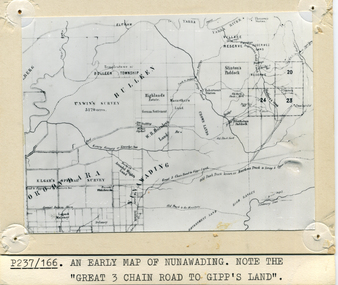 Whitehorse Historical Society Inc.
Photograph - B/W Photograph, Map of Nunawading
Black and white photo of early sub-division of Nunawading.|NOTE:- Great 3 Chain Road to Gipp's Land.nunawading, map -
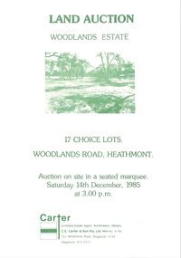 Ringwood and District Historical Society
Pamphlet - Land Sales Brochure, Woodlands Estate, Heathmont, 1985
Bifold pamphlet with picture on front, one inside plus plan of Woodlands Road sub division and locality plan on back page. All in green print. Copy enclosed with handwritten sale prices. Auctioneer's notes (Richard Carter) indicate vendor - Estate of Phoebe Beard.Auction on site in a seated marquee, Saturday 14th December, 1985. Agent - C.E. Carter & Son Pty. Ltd., 122 Whitehorse Road, Ringwood, 3134. Telephone 870 6211. -
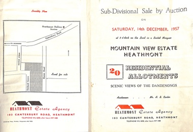 Ringwood and District Historical Society
Flyer - Land Sales Brochure, Sub-Divisional Sale by Auction - Mountain View Estate, Heathmont, Victoria - 1957
Bi-fold pamphlet advertising auction of 20 residential allotments on Saturday, 14th December, 1957, with description of services available and finance terms. Subdivision inclues Orchard Grove and Barnic Road. Agent - Heathmont Estate Agency, 103 Canterbury Road, Heathmont, Telephone WU6808, after hours WF1488. Auctioneer Mr. A.B. Carter. Accompanying Parish of Ringwood survey map with cardboard backing - Part of Crown Allotment 14B, includes handwritten price notations for each allotment.