Showing 11003 items matching " lander"
-
 Tatura Irrigation & Wartime Camps Museum
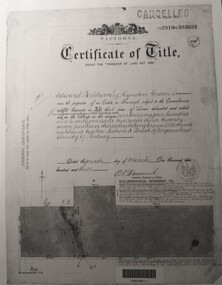
Document, Certificate of Title Edward Baldwin
Certificate of title and corresponding copies of information relating to the purchase of land by Edward Baldwin of Kyneton. Vol 2919 folio 5836823 A4 pieces of paper with photocopied copies of certificate of title and two other documents relating to purchase of land.edward baldwin, certificate of title, vol 2919 fol 583682 -
 Orbost & District Historical Society
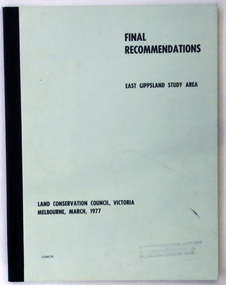
document, FINAL RECOMMENDATIONS E. GIPPSLAND STUDY AREA - LAND CONSERVATION COUNCIL, VICTORIA March 1977, March 1977
Established in 1971, the Land Conservation Council operated under the Land Conservation Council Act 1970. In July 1997, the Environment Conservation Council Act 1997 came into operation. This Act revoked the Land Conservation Council Act 1970 and abolished the Land Conservation Council. An Environment Conservation Council was established in its place. (ref. TROVE) This document is a useful reference tool.A document of 75 pp with a pale green cover and black print, titled Final Recommendations East Gippsland Study area. Land Conservation Council, Melbourne, March, 1977.land-conservation-east-gippsland -
 Greensborough Historical Society
Document - Certificate of Title, Flintoff land, 1897o
1. Certificate of Title: Edith Flintoff 26/10/1897: Vol. 2659 Fol.531750. 2. Transfers of (1) Edith Flintoff, Edith Fullwood, John Bosch. 3. List of transfers from Frederick Nevins Flintoff including to Robert Whatmough and John McLaughlin. 4. Plenty River to Diamond Creek Road (plan) shows land belonging to Edith Flintoff, Edith Fullwood, John Bosch. 5. Register of proprietors including Edith Flintoff of Nillumbik, Portion 14, Vol. 2659 Fol.531750.Shows part of the chain of ownership of this parcel of land in Greensborough.5 pages. Copies of land titles and associated documentsflintoff family, land titles - greensborough -
 Mont De Lancey
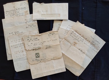
Document - Land Receipts, M. H. Proctor, H. Proctor & W Hunter, 1946 - 1951
These are handwritten land receipt documents between Maxwell Proctor and W. Hunter (owner) 1946 - 1951 and between M.H. Proctor and H. Proctor 1947, 1948 and 1949.Two sets of handwritten land receipts in a used envelope with blue type at the bottom: Chamber of Manufactures Insurance Ltd. The first set of three receipts are written in copperplate handwriting for Mr. M. H. Proctor and are for the purchase of land, from W. Hunter (owner of the land). They are dated Feb 28th 1946, 17th April 1951 and an indecipherable date o the last one. The second set of six handwritten receipts are from M. H. Proctor to H. Proctor for land purchased: May 27th 1947, Dec 7th 1947, June 22nd 1948, Dec 14th 1948, May 30th 1949 and Dec.6th 1949. All letters are handwritten with a small green or yellow 3d. official Stamp Of Victoria glued to them. They are all signed by W Hunter or H. J. Proctor.legal documents, documents, land sales, contracts -
 Whitehorse Historical Society Inc.
Article, Farm digs in against closure, 2013
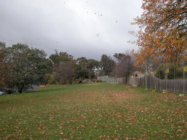
Land reserved for Healesville Freeway is at risk of being broken up for housing.Land reserved for Healesville Freeway is at risk of being broken up for housing. Some of the area is used at present for a farm run by NADRASCA, and other land is the nature reserve, Bellbird Dell. More than 1500 protested against the closure to local MP Shaun Leane.Land reserved for Healesville Freeway is at risk of being broken up for housing. healesville freeway reservation, bellbird dell, nadrasca, leane, shaun, vermont, koedyk, gus, turner, raeoni, kayne, rodney, basic, peter, vicroads -
Clunes Museum
Document - DOCUMENT - COVENANT, PRIMITIVE METHODIST CHAPEL
LAND TO BUILD PRIMITIVE METHODIST CHAPEL ONCOVENANT BETWEEN TALBOT LAND BUILDING INVESTMENT SOCIETY AND THE PRIMITIVE METHODIST CHAPEL IN CLUNES DATED 29/05/1877 FOR ALLOTMENT 12 SECTION 6.primitive methodist chapel, talbot land building and investment society -
Stawell Historical Society Inc
Badge - Realia, IOOF Victoria Australia
Membership badge for International Order of Oddfellows. Victoria AustraliaEnamelled Badge. Gold wings on top over blue with IOOF and Chain over top. Red Enamel outer with Victoria Australia?land and King Melborne -
 Bendigo Historical Society Inc.
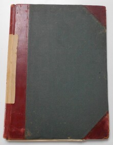
Document - LANDS OFFICE : TANDARRA ESTATE, COUNTY OF BENDIGO, 1906 - 1920
Document: green bound hard cover journal with red spine binding and corners. On spine ' Tandarra' written in black. Journal contains details of allotments leased in the Tandarra Estate. Maps and letters relating to blocks are enclosed. LH page: details of lessee, improvements (year range 1906 - 1920) , RH page: residence, population, results of cultivation, stock etc., remarks re lessee's gains or losses each year.Land and Survey Officerland leases, tandarra, bendigo, sandhurst, lands office, land settlement -
 Kew Historical Society Inc
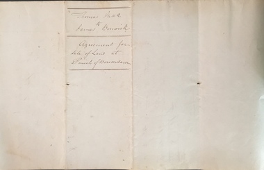
Legal record (Item), Thomas Judd to James Bonwick: Agreement for Sale of Land at Parish of Boroondara, 1853, 28/02/1853
James Bonwick (1817-1906), the Victorian educator and historian, acquired land in Kew on which to establish a home and school in 1853, not 1854 as more commonly stated. Bonwick returned to England in 1859 for a period, later returning to Melbourne and settling in St Kilda. He was the author of a number of histories and an official transcriber of Government records.This newly acquired document, from a former owner of 'Parkhill' (20 Hillcrest Avenue, Kew), is of statewide importance as it is the original copy of the agreement made between Thomas Judd of Parkhill and James Bonwick in 1853 for the purchase of land in Kew. Both Thomas Judd and James Bonwick were significant pioneers of Victoria.TRANSCRIPT [TITLE] Thomas Judd to James Bonwick Agreement for Sale of Land at Parish of Boroondara [PAGE 1] Articles of agreement made and entered into this the Twentyth eighth day of February One thousand Eight Hundred and fifty three Between Thomas Judd of Melbourne in the Colony of Victoria Gentleman of the one part and James Bonwick of Melbourne in the Colony of Victoria Gentleman of the other part whereby the said Thomas Judd agrees to sell unto the said James Bonwick who hereby agrees to purchase a piece or parcel of land containing two and half acres be the land more or less part of Portion Number Eighty five of the Parish of Boroondara in the County of Bourke commencing at a point on the Northern boundary line of the said Portion Seventeen Chains fifty links East from the North West angle of the same and bounded on the East by other part of said Portion in a line bearing South Eight Hundred and sixty two feet on the South by other part of said Portion Eighty five in a line bearing West one Hundred twenty six and half feet on the West by other part of said Portion Eighty five in a line bearing North Eight Hundred and Sixty two feet on the North by the Northern boundary line of the said Portion Eighty five in a line bearing East one Hundred twenty six and half feet to the commencing point at or for the price or sum of one [PAGE 2] One Hundred Pounds to be paid and payable in the manner hereinafter mentioned that is to say the Sum of Thirty pounds to be paid on the day of the date hereof and the sum of forty pounds by the acceptance of the said James Bonwick for that sum at three months bearing interest thereon after the rate of Eight Pounds per centum per annum and the Sum of Thirty pounds by the acceptance of the said James Bonwick for that sum after Six months with interest thereon after the rate of Eight pounds per centum per annum It is furthermore agreed that the said James Bonwick shall have access by a right of way fifteen feet wide reserved by the said Thomas Judd to the Government Road being the Southern Boundary of Portion Eighty five. That in case default shall be made in the payment of any of any of the Acceptances above mentioned the amount paid shall be actually forfeited to the said Thomas Judd who shall be at liberty to resell the premises. That upon payment of the whole amount of the purchase money the said Thomas Judd shall execute a conveyance of the premises to the said James Bonwick Such conveyance to be prepared by and at the expense of the said James Bonwick who - [PAGE 3] who shall also pay the cost of any attested copies he may require. ---- As witness the hands of the said parties this the twenty first day of February one thousand Eight Hundred and fifty Three. ----- [Signature] T. Judd [Signature] Jas Bonwick Witness [Signature illegible] £ Received Cash on account of the above 30.0.0 Thirty Pounds Bill at three Months with interest 42.4.0 Bill at Six Months with interest 31.4.0 _____ £103.8.0 _____ [Signature] T. Judd [Signature] Jas Bonwick ------------ Transcribed David White 25/08/2020 james bonwick, thomas judd, land titles - kew (vic), pioneers - kew - victoria -
 Wodonga & District Historical Society Inc
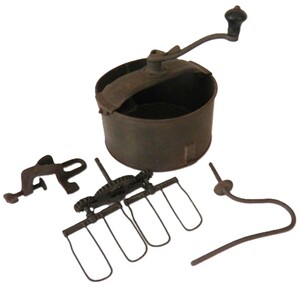
Domestic object - Universal Cake Mixer, Landers, Frary & Clark, c1905
Landers, Frary & Clark was a housewares company based in New Britain, Connecticut. The firm traced its origins to 1842, when George M. Landers and Josiah Dewey entered into a partnership named Dewey and Landers, which manufactured various metal products. The company was reorganized as Landers, Frary & Clark in 1862. The firm produced a variety of household products and appliances, including many electric appliances. Some of Landers, Frary & Clark's most successful products included the Universal Bread Maker, the Universal Food Chopper, and the Coffee Percolator. In 1965, the majority of the Landers, Frary & Clark was taken over by the J.B. Williams Company of New York, the food chopper division was acquired by the Union Manufacturing Company, and the electrical appliance operations was purchased by General Electric. The mixer consists of a bowl made of tinned iron with accessories including wire twin beaters, a dough hook, a table /bench clamp, and a handle with a wooden hand grip. An arched cross bar attached to the top of the pan with wing nuts holds the handle and beaters or hook in place when in use. Manufacturer and patent information is inscribed on the cross bar.On the cross piece: UNIVERSAL/CAKEMAKER/PATENTED/JAN.14,96.APRIL18,05./JULY.18,05.NOV.7,05 LANDERS,FRARY/CLARK/NEW BRITAIN/CONN/USAdomestic appliances, cooking utensils -
Whitehorse Historical Society Inc.
Article, Antonio Park Primary School, 1958
Article detailing dealings between Education Department, Nunawading Council and Mr. AntonioArticle detailing dealings between Education Department, Nunawading Council and Mr. Antonio regarding acquisition of land for a State School on site of Antonio Park.Article detailing dealings between Education Department, Nunawading Council and Mr. Antonio antonio, e., antonio park, mitcham, antonio park state school, city of nunawading, victoria. education department -
Whitehorse Historical Society Inc.
Document, Healesville Freeway Reservation Renewal Project, 2012
Agenda of meeting between VicRoads and Whitehorse Historical Society 1 Feb 2012.Agenda of meeting between VicRoads and Whitehorse Historical Society 1 Feb 2012, with supplementary documentation of boundaries, project purpose, and current land useAgenda of meeting between VicRoads and Whitehorse Historical Society 1 Feb 2012.forest hill, vermont, vermont south, healesville freeway reservation, vicroads -
Whitehorse Historical Society Inc.
Document, William James Moffatt, 1866-1945
Information about William James Moffatt, an orchardist in Mahoneys Road, Burwood East.Information about William James Moffatt, an orchardist in Mahoneys Road, Burwood East, after purchasing land there in 1907 and until his death in 1945.Information about William James Moffatt, an orchardist in Mahoneys Road, Burwood East. moffatt, william james, orchardist, orchards, mahoneys road, burwood east, moffatt, ian -
 Kew Historical Society Inc
Legal record - The Indenture, Crown Portion 86, otherwise known as 'The Morgan Deed', 1852 (and later)
This indenture once formed part of the City of Kew's Municipal Collection. Cr. W.D. Vaughan in his history 'Kew's Civic Century' (1960) records on page 194 that: "The original deed of conveyance of the land being all of Crown Portion 86, Kew, purchased by John Quick, James Venn Morgan, Samuel Derrick and William Derrick was presented by the Historical Society of Victoria on behalf of Mrs Fryer, a daughter of the later J.V. Morgan, to the [Kew] Council on August 5, 1941. Crown Portion 86, comprised all the land between Cotham Road and High Street to an alignment opposite the east boundary of Glenferrie Road. On it the first residential house was built by Mr. J.V. Morgan in 1852." Following the donation, the Indenture was surrounded by other original related text and explanatory notes and framed. The resulting framed documents are the largest framed objects in the collection.The Indenture and the accompanying contextual documents are some of the most historically significant manuscripts to have survived since the settlement of Kew in the 1850s. They provide a link to Kew's most famous pioneering families.Framed 1952 Indenture recording the sale of land in Kew to pioneering Kew families.james venn morgan, john quick, william derrick, samuel derrick, kew (vic) - history, kew (vic) - pioneers, samuel watts, kew (vic.) — municipal collection -
 Phillip Island and District Historical Society Inc.
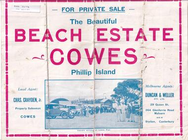
Brochure, Beach Estate Cowes, c 1940's
Advertising Land for Sale in Cowes, Phillip IslandFour page colour Brochure advertising land in Devon Avenue and Cornwall Avenue, Cowes, For Sale. Illustrations of Cowes Pier, The Beach at Cowes and motoring on the Island.Four pages of Real Estate lingo!! Agents - Chas Grayden Jnr, Cowes and Duncan & Weller, Malvernreal estate, cowes phillip island, charles grayden jnr., cowes, duncan & weller, malvern & canterbury -
Ringwood and District Historical Society
Contracts, Acquisition of the land in Grey Street and Ware Crescent, Ringwood East by the Graduates Assoc. of the Kindergarten Training College, Melbourne. 1950-1960, 1950-1960
Various papers from the titles Office, City of Ringwood Solicitors for accounts on the purchase of the land by the Graduates of the Kindergarten Training College and caveats pertaining to the land. This was the site of the Warrawong day and residential care kindergarten which was demolished c.2000 to be divided into housing blocks.18 pages of documents relating to the acquisition of the land in Grey Street and Ware Crescent, Ringwood East by the Graduates Assoc. of the Kindergarten Training College, Melbourne. -
Whitehorse Historical Society Inc.
Map, Subdivision of Allotment 122a, 1972
Subdivision of land along Livermore Close and Moore Road, Vermont South.Subdivision of land along Livermore Close and Moore Road, Vermont South. Original survey Rob Poole 1899. Stamp indicates 'Land on this plan is in proclaimed survey No 21. Survey Coordination Act 1940. As from 9 Aug 1972. Two maps in different scales.Subdivision of land along Livermore Close and Moore Road, Vermont South. land subdivision, livermore close, vermont south, moore road, vermont south, dandenong creek -
Whitehorse Historical Society Inc.
Article, Winlaton faces closure, 1993
Winlaton, now known as Nunawading Youth Residential Centre will close and relocate.Winlaton, now known as Nunawading Youth Residential Centre will close and relocate to the Baltara Reception Centre in Parkville and the remaining 8.4 ha land will be sold.Winlaton, now known as Nunawading Youth Residential Centre will close and relocate.youth services, winlaton, nunawading youth residential centre -
 City of Moorabbin Historical Society (Operating the Box Cottage Museum)
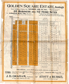
Flyer - Golden Square Estate, Bentleigh, 1923
Land sales in the Municipality of Moorabbin increased when the train line from the City to Frankston was electrified.Example of the progress of the Municipality of MoorabbinThe train line from the city to Frankston was electrified which intensified the sale in the municipality of Moorabbin, particularly land which was in the vicinity of the railway stations.Golden Square Estate, Bentleigh - J. D. Graham, Stott & Burke - 25 business sites and 112 home sitescentre road, brewers road, jasper road, robert street, mitchell street, daley street, bendigo avenue, auction, real estate, moorabbin, bentleigh -
 Ballarat Heritage Services
Photograph - Colour, Clare Gervasoni, Borsa Crescent, Hepburn Springs, from Bellinzona, 2004, 28/06/2004
The block of land depicted has been leveled with a huge rock barrier around the corner perimeter.Block of land on the corner of Borsa Crescent and Seventh Street taken not long after Bellinzona and Wanda Inn had been burnt down.bellinzona, actea, hepburn springs, church avenue, seventh street, borsa crescent, wanda inn, fire -
4th/19th Prince of Wales's Light Horse Regiment Unit History Room
Pamphlet, Royal Australian Armoured Corps Advanced Signal Training 1981, 1981
Used by the RegimentSoft covered loose leaf book, the RAAC extract from the Manual of Land Warfare Part Two, Signal Training Volume 2 detailing communications techniques and radio telephone proceduresRoyal Australian Armoured Corps Advanced Signal Training. RAAC extract from the Manual of Land Warfare Part Two, Signal Training Volume 2 Communications Techniques Pam No 3 Telephone Procedures (All Corps) 1980signals training, royal australian armoured corps, handbook -
 Ballan Shire Historical Society
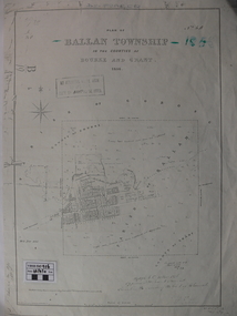
Map - Map. Ballan Township, Plan of Ballan Township in the Counties of Bourke and Grant
The map is an early one of the township of Ballan showing street names and land owners.The map is significant in that it lists the owners of the house blocks within the township.A map showing the township and surrounding area of Ballan in 1856. Town streets are named as are the owners of the subdivided blocks of land. The map is a lithocopy and there is a scale in chains."D D Fraser" is written across the top of the map and "1856" is written in the near top right corner. There are other additions to the map but they are very difficult to decipher accurately or completely.ballan, ballan township map, ballan1856 -
Ringwood and District Historical Society
Envelope, Nunawading, Ringwood, East Ringwood Land Subdivision Sales, and Grid Map of Melbourne
Land Subdivision Sales - Nunawading; Land Subdivision Sales - East Ringwood; Land Subdivision Sales - Ringwood; Land Subdivision Sales - Grid map of Melbourne -
 Kiewa Valley Historical Society
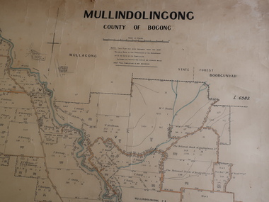
Parish Map - Mullindolingong, County of Bogong
The Department of Lands regularly updated the occupiers with leases or licences of the land.The names of the early settlers of the Kiewa Valley occupying land by lease or licence are shown. Many of these familie's descendants still live in the Kiewa Valley.Government (Lands Department?) cloth map showing the leases or licenses of occupiers of the land in the valley. The Kiewa River is shown in blue and roads in yellow. There is no date on the map.parish of mullindolingong map, settlers of the kiewa valley -
 National Vietnam Veterans Museum (NVVM)
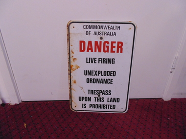
Sign - Sign, Danger
A white rectangular metal sign with rounded corners and a black line border. It has holes drilled in four corners. plus two larger central holes for fixing it to wall or pole and is rusted on the left side. Centre justified warning message reads: Commonwealth Of Australia (in black)/ DANGER (in red) /Live Firing/ Unexploded/Ordnance/ Trespass/ Upon This Land/ Is Prohibited. Centre justified message reads: Commonwealth Of Australia (in black)/ DANGER (in red) /Live Firing/ Unexploded/Ordnance/ Trespass/ Upon This Land/ Is Prohibited. sign, commonwealth of australia, danger, warning -
Ringwood and District Historical Society
Land Sale Documents, Board of Land and Works, Documents pertaining to application for a land grant around Ringwood Lake in 1874, 30-May-1870 and 25-Mar-1874
This concerns the application and granting of land to Anthony Ford around the Ringwood lake area in 1874. Includes details of improvements made to the area, including a dwelling. The land is described as being very poor and not worth the labour of cultivation. 8pp.Documents pertaining to application for a land grant around Ringwood Lake in 1874. Copied documents, cream paper. 8pp. +Additional Keywords: Ford, Anthony / Kennedy, James -
4th/19th Prince of Wales's Light Horse Regiment Unit History Room
Manual - Folder, loose leaf, Royal Australian Armoured Corps Signal Training 1985, 1985
Used by the RegimentSoft covered loose leaf book. The RAAC extract from Manual of Land Warfare Part 2 Signal Training Volume 2, detailing procedure to be used for radiotelephone communications throughout the Army. Includes Amendment list No 1.RAAC Signal Training 1985. RAAC Extract from Manual of Land Warfare Part 2. Signal Training Volume 2, Pamphlet No 3. Radio Telephone Procedure (All Corps) 1983hand book, radio training, royal australian armoured corps -
Ringwood and District Historical Society
Certificate of Title, Certificate of Title of land in Summit Crescent, North Ringwood
Given to the Society by Marg ... Certificate of a title for a block of land in Summit Crescent, North Ringwood.Certificate of Title of land in Summit Crescent, North Ringwood: two white pages of original photocopied double sided. +Additional Keywords: Rushworth, Maggie -
Whitehorse Historical Society Inc.
Document, Land Transfer, 1919
Notice from Patrick Joseph Markham to Commissioner of Taxes.Notice from Patrick Joseph Markham to Commissioner of Taxes of sale of land Vol 4035 Folio 806811 to George Dodsworth 10 Jun 1919Notice from Patrick Joseph Markham to Commissioner of Taxes.markham, patrick joseph, dodsworth, george, whitehorse road mitcham -
 Bacchus Marsh & District Historical Society
Map, Plan of land purchased by the Bacchus Marsh Shire Council from Mr. T. Low for a deviation of the Melbourne to Ballarat main road. 1877
The date of this plan is 1877 and the land indicted on it required for a road deviation is shaded in blue. It adjoins the Korkuperrimul Creek on one side which indicates the land is located just a few kilometers to the west of Bacchus Marsh. Single page map showing a portion of land purchased by the Bacchus Marsh Shire from Mr Thomas Low for the purpose of a road deviation. Land held by David Robertson is also shown on the map. Scale: 2 chains to 1 inch. Part of a set of maps which are pasted into a bound volume containing 76 maps or plans in total. High resolution digital image stored on BMDHS computer network. Surveyed by W. E. Standfield, Shire Engineer, Bacchus Marsh, 12/4/77bacchus marsh roads and streets, melbourne to ballarat road