Showing 167 items matching " nepean highway"
-
 City of Kingston
Photograph - Black and white, 5 January 1984
... (bottom left), Nepean Highway (left section), Graham Road... Department is visible on Nepean Highway Highett. The CSIRO Highett ...Moorabbin, Cheltenham and Highett are suburbs in the City of Kingston with a diverse mix of development and zoning. The market gardens, farms and paddocks have gradually been sub-divided into housing and industrial estates and associated infrastructure such as schools and shopping facilities. The area includes many parks, reserves and golf courses.This aerial image covers a diverse section of the City of Kingston, taking in the suburbs of Cheltenham, Moorabbin, Beaumaris and Highett. By 1984, the market gardens of the district have been replaced by housing and factories. The Gas and Fuel state-of-the-art Scientific Services Department is visible on Nepean Highway Highett. The CSIRO Highett site can also be seen. Both sites have now been demolished and have undergone remediation. The Southland site is visible and yet to be redeveloped by Westfield. This image portrays the diversity of development in the City of Kingston with a mixture of green spaces, housing and commercial and industrial features.Aerial photograph of Cheltenham, Beaumaris, Moorabbin and Highett within the City of Kingston. The area depicted in the 1984 aerial view includes Eden Street and Edward Street, Cheltenham (top left), Weatherall Road and Reserve Road, Cheltenham/Beaumaris (top right), Turner Road and Chesterville Road, Moorabbin (bottom left), Nepean Highway (left section), Graham Road and Middleton Street, Highett (bottom right). A large section of this image includes Cheltenham Park and Victoria Golf Club.White text: 3831-219 Lens information [indecipherable] RINGWOOD M/S 7922-3 RUN 15 Clockface image 5,300' ASL VIC DLS© 5-1-84cheltenham, highett, industrialisation, urbanisation, moorabbin, beaumaris -
 Chelsea & District Historical Society Inc
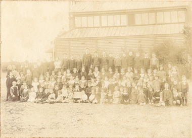
Photograph - Chelsea State School, Children outside Hoadleys Hall "Joss House", 1914
... , near the Nepean Highway. Due to its Oriental appearance..., near the Nepean Highway. Due to its Oriental appearance ...In January 1912, a small school was established at Chelsea, with 65 students, in Hoadley’s Hall, located on Main Road, Chelsea, near the Nepean Highway. Due to its Oriental appearance, the local people called this hall “The Joss House.” Hoadley's Hall was was originally used at the Melbourne Show Grounds by Hoadley's which was moved to Chelsea. The Hall was also used for church services by different religions before they built their own churches. A new brick school was built on Argyle Avenue and officially opened on 27 January 1915.Sepia photo of children and adults at Chelsea State School, in 1914, standing in front of Hoadley's Hall.chelsea, education, chelsea primary school, school, hoadleys hall, joss house, chelsea state school -
 Chelsea & District Historical Society Inc
Photograph - Chelsea State School, Children outside Hoadleys Hall "Joss House", 1912
... , near the Nepean Highway. Due to its Oriental appearance..., near the Nepean Highway. Due to its Oriental appearance ...In January 1912, a small school was established at Chelsea, with 65 students, in Hoadley’s Hall, located on Main Road, Chelsea, near the Nepean Highway. Due to its Oriental appearance, the local people called this hall “The Joss House.” Hoadley's Hall was was originally used at the Melbourne Show Grounds by Hoadley's which was moved to Chelsea. The Hall was also used for church services by different religions before they built their own churches. A new brick school was built on Argyle Avenue and officially opened on 27 January 1915.Sepia photo of children and adults at Chelsea State School, in 1912, standing in front of Hoadley's Hall.chelsea, education, chelsea primary school, school, hoadleys hall, joss house, chelsea state school -
 Chelsea & District Historical Society Inc
Photograph - Chelsea State School, Mr Rogers with staff and family, 1918
... , near the Nepean Highway. Due to its Oriental appearance..., near the Nepean Highway. Due to its Oriental appearance ...In January 1912, a small school was established at Chelsea, with 65 students, in Hoadley’s Hall, located on Main Road, Chelsea, near the Nepean Highway. Due to its Oriental appearance, the local people called this hall “The Joss House.” Hoadley's Hall was was originally used at the Melbourne Show Grounds by Hoadley's which was moved to Chelsea. The Hall was also used for church services by different religions before they built their own churches. Chelsea State School was built on Argyle Avenue and officially opened on 27 January 1915.Sepia photo of Mr Rogers, his staff and family. Mr Rogers was the first Head teacher of Chelsea State School from 1912 to 1917.chelsea, education, chelsea primary school, school, students, school yard, mr rogers, teachers, chelsea state school -
 Chelsea & District Historical Society Inc
Photograph - Chelsea State School, Students, staff and Family on a picnic, c 1912-14
... , near the Nepean Highway. Due to its Oriental appearance..., near the Nepean Highway. Due to its Oriental appearance ...In January 1912, a small school was established at Chelsea, with 65 students, in Hoadley’s Hall, located on Main Road, Chelsea, near the Nepean Highway. Due to its Oriental appearance, the local people called this hall “The Joss House.” Hoadley's Hall was was originally used at the Melbourne Show Grounds by Hoadley's which was moved to Chelsea. The Hall was also used for church services by different religions before they built their own churches. A new brick school was built on Argyle Avenue and officially opened on 27 January 1915.Sepia photo of children, staff and family from Chelsea State School, at a picnic, amongst the te trees.chelsea, education, chelsea primary school, school, hoadleys hall, joss house, picnic, te trees -
 Chelsea & District Historical Society Inc
Photograph - Chelsea State School, Children outside Hoadleys Hall "Joss House", 1912
... , near the Nepean Highway. Due to its Oriental appearance..., near the Nepean Highway. Due to its Oriental appearance ...In January 1912, a small school was established at Chelsea, with 65 students, in Hoadley’s Hall, located on Main Road, Chelsea, near the Nepean Highway. Due to its Oriental appearance, the local people called this hall “The Joss House.” Hoadley's Hall was was originally used at the Melbourne Show Grounds by Hoadley's which was moved to Chelsea. The Hall was also used for church services by different religions before they built their own churches. A new brick school was built on Argyle Avenue and officially opened on 27 January 1915.Black and white photo of children at Chelsea State School, in 1912, standing in front of Hoadley's Hall.chelsea, education, chelsea primary school, school, hoadleys hall, joss house -
 Glen Eira City Council History and Heritage Collection
Adepsol Bottle
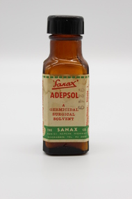
... / THE SANAX CO. / 849-51 NEPEAN HIGHWAY / MOORABIN / TEL XU 2651... / THE SANAX CO. / 849-51 NEPEAN HIGHWAY / MOORABIN / TEL XU 2651 ...This Adepsol Bottle is part of a Sanax First Aid Case which was used at the the former Carnegie Senior Citizens' Centre. The centre was located at 314 Neerim Road, Carnegie. When the Neerim Road facility closed, its activities were moved to the Carnegie Library and Community Centre. For Occupational Health and Safety reasons, Council no longer maintains first aid kits at senior citizens' centres. Brown glass bottle with red, green and white paper label with Sanax branding, and usage directions. Black plastic screw-top lid. Bottle has been decanted however some white powder residue remains. "Sanax" ADEPSOL/ A GERMICIDAL / SURGICAL / SOLVENT / THE SANAX CO. / 849-51 NEPEAN HIGHWAY / MOORABIN / TEL XU 2651 / Directions: Dilute 1 in 4 with warm water for bathing Wounds, dab dry with absorbent cotton, then apply Germicide and dressing. For removing Germs, Grease, and Dirt from Wounds and Burns before finally dressing Wounds. -
City of Kingston
Photograph - Colour, c. 1993
... , Kananook Creek and Nepean Highway. The railway line can be seen... Reserve, Kananook Creek and Nepean Highway. The railway line can ...Patterson Lakes is a suburb in the City of Kingston that is built one kilometre upstream of the mouth of the Patterson River. The area is bordered by the Patterson River and Eel Race Drain which enters the Kananook Creek. The suburb consists predominantly of newer housing developments and the tidal canal system of the development joins Port Phillip Bay.Patterson Lakes and the Kananook Creek were previously part of the extensive Carrum Carrum Swamp. The area was once a source of fish and eels for the Mayone-Bulluk clan of the Bunurong people. Over time the area was drained and in 1973 investigations commenced into the development of a unique residential area that would be built adjacent to canals and waterways. It was originally proposed to be known as "Gladesville". The development would give the suburb's homeowners access to Port Phillip Bay "from their back door". Circa 1974, the area was rezoned from rural to residential and named Patterson Lakes. Development has been continuous since the 1970s with construction of residential housing, schools, shopping centres, marinas, a hotel and library.Laminated colour aerial photograph of the Carrum and Patterson Lakes region within City of Kingston. This 1993 image includes Patterson River Secondary College, Roy Dore Reserve, Kananook Creek and Nepean Highway. The railway line can be seen as it veers inland from Eel Race Road, Seaford. The section of Palm Beach Drive, Curlew Point Drive, Snapper Point Drive, Clipper Island and Myola Street in Patterson Lakes appears to be a recent development with many spare blocks and new houses under construction.patterson lakes, seaford, kananook creek, carrum carrum swamp, canals and waterways -
 City of Moorabbin Historical Society (Operating the Box Cottage Museum)
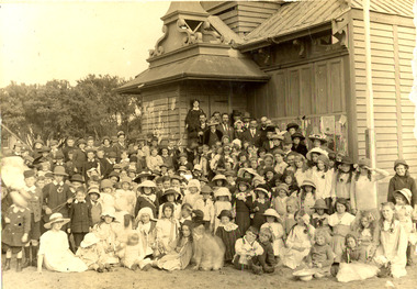
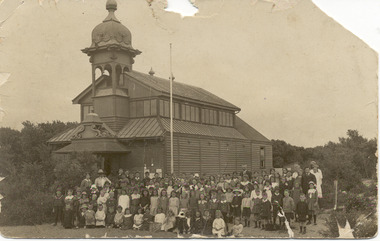
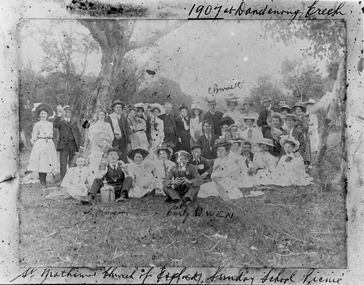
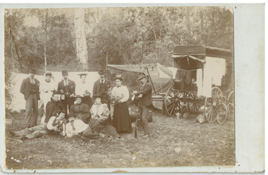
Photograph - St Matthew's Church of England Sunday School Picnic 1907, 1907
... the Nepean Highway near Charman Road. The early settlers established... of England was erected in Cheltenham beside the Nepean Highway near ...The Anglican Cheltenham parish was created in 1865 by excising a portion of the parish of St Andrews Brighton. A small brick church was completed in 1867 to serve a rural community stretching from Brighton South (Moorabbin) to Mordialloc. 1867 St Matthew's Church of England was erected in Cheltenham beside the Nepean Highway near Charman Road. The early settlers established a tennis club, cricket team and social groups. A typical social event was the annual Sunday School Picnic held in 1907 at Dandenong Creek.Young members are mentioned Curly Owen,C,Burnett,A Manett St Matthew's Church of England Cheltenham was erected in 1867 and was integral to the spiritual well being and social life of the early settlers.Black & White photograph of the St Matthew's Church of England Sunday School Picnic 1907Handwritten Curly Owen, C, Burnett, A Manett st. matthew's church of england cheltenham, sunday school picnics, anglican church, st andrew's church brighton, owen curly, burnett c . manett a, horse drawn carts, toll gates brighton, motor cars 1900, steam engines, early settlers, bentleigh, parish of moorabbin, city of moorabbin, county of bourke, moorabbin roads board, shire of moorabbin, henry dendy's special survey 1841, were j.b., bent thomas, o'shannassy john, king richard, charman stephen, highett william, ormond francis, maynard dennis, market gardeners, vineyards, orchards -
 City of Moorabbin Historical Society (Operating the Box Cottage Museum)
Clothing - Clothing, City of Moorabbin Tie, Circa 1960s
... , Lower Dandenong Road, then South along Nepean Highway..., then South along Nepean Highway to Balcombe Road and along Bluff Road ...The City of Moorabbin existed from 1934 until 1994. Henry Dendy's Special Survey in 1841 of 5,120 acres in the Parish of Moorabbin , extended from Port Phillip Bay , then East to Boundary Road, South to South Road and North to North Road and became known as Brighton. 1859 Brighton became a Borough with its boundary Thomas Street ,and Bluff Road. In 1862 The Moorabbin Roads Board was formed and the extended area now included Cheltenham, Hampton, Sandringham, Black Rock, Beaumaris, Mentone and Mordialloc .and Little Brighton became known as Bentleigh. In 1871 the area became known as The Shire of Moorabbin. Gradually the area was separated into The Borough of Sandringham 1917, ( Black Rock, Beaumaris , Sandringham and Hampton ) Borough of Mentone and Mordialloc 1920, ( Parkdale ). In 1934 The City of Moorabbin was established for the area from South East corner of Thomas Street and North Road , East to Warrigal Road, Clayton Road, Kingston Road , Lower Dandenong Road, then South along Nepean Highway to Balcombe Road and along Bluff Road, Cummins Road, Nepean Highway, Thomas Street to North Road In the 1994 Amalgamation of Councils the City of Moorabbin was divided between the new City of Kingston in the South ( from South Road) and the new City of Glen Eira to the North . It was the largest Municipality in Victoria with a population of 118,865 in 1974This tie c 1960 is a memento of the City of Moorabbin 1934 - 1994Maroon colour, polyester, man's tie with the crest of City of Moorabbin woven on front.around circle enclosing Coat of Arms ; CITY OF MOORABBIN city of moorabbin, moorabbin roads board, moorabbin, brighton, dendy's special survey 1841, early settlers, pioneers, market gardners, dendy henry, were jonathan b, cheltenham, bentleigh, mentone, sandringham, mair william, bent thomas -
City of Kingston
Photograph - Black and white, 3 March 1954
... . Nepean Highway and the Frankston railway line run centrally... and Jack Barker Oval are visible. Nepean Highway and the Frankston ...Cheltenham and Moorabbin are suburbs within the City of Kingston that were originally established as rural market gardening communities The area is bordered by Highett and Mentone. The market gardens, farms and paddocks have gradually been sub-divided into housing and industrial estates. Highett is developed with residential homes but was also the site of major facilities such as the Highett Gas Works. This aerial image covers a diverse section of the City of Kingston, taking in the suburbs of Moorabbin, Cheltenham, Highett and Mentone Residential housing development is prominent along the Frankston Railway line and the area still retains extensive market gardens and paddocks yet to be converted to a large industrial and commercial zone.Aerial photograph of Mentone, Cheltenham and Moorabbin within the City of Kingston. The area depicted in this 1954 aerial view includes Warrigal Road and Centre Dandenong Road intersection (top left); Charman Road, Patty Street, Bourke Street, Collins Street Mentone (top right); Keys Road Moorabbin (bottom left); Bay Road, Cheltenham (bottom right), Friendship Square, Cheltenham Park, Victoria Golf Club and Jack Barker Oval are visible. Nepean Highway and the Frankston railway line run centrally through the image. Highett Gasworks is also evident.White handwriting and type [indecipherable]. White image of clockface White image of compass White type 42956 Black handwriting 3/3/54 Williams [indecipherable] Black pencil: S [arrow] Black ink: 3/3/1954cheltenham, moorabbin, mentone, highett, market gardens -
 City of Moorabbin Historical Society (Operating the Box Cottage Museum)
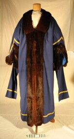
Ceremonial object - City of Moorabbin Mayoral Robe c1960, circa 1960
... and Jabot with Cuffs for display at KCC Officess Nepean Highway... with Cuffs for display at KCC Officess Nepean Highway Cheltenham ...This robe was the last City of Moorabbin Mayoral Robe, and was worn by Mayor Ron Brownlees, (prior to the City of Moorabbin's amalgamation with City of Glen Eira and City of Kingston in 1994). It was donated to the City of Moorabbin Historical Society in February 2007 by the City of Kingston. 12/11/2018 Cr Steve Staikos MAYOR City of Kingston requests that CMHS loan the Mayoral Robes and Jabot with Cuffs for display at KCC Officess Nepean Highway Cheltenham on going 7 Years. The Moorabbin Mayoral Robe with Jabot is displayed along with those of former City of Chelsea Robes and former City of Mordialloc Robes at Kingston City Council Office . The KCC possesses the Mayoral Chains of each former Council and they are displayed on the Mayoral Robes for the Annual Opening meeting of KCC in February .The City of Moorabbin developed from the Moorabbin Roads Board of 1862, becoming The Shire of Moorabbin in 1871 and the City of Moorabbin in 1934. In the 1994 Amalgamation of Councils the City of Moorabbin was divided between the new City of Kingston in the South and the new City of Glen Eira to the North . This is the last Mayoral Robe for the City of Moorabbin 1934- 1994City of Moorabbin Mayoral Robe. Full length garment of royal blue material, 55% Polyester & 45% Wool, with gold braid on hem and sleeves. Full length Collar and the cuffs are brown mink and sleeves are lined with blue satin. Two brass clips on shoulders are for the attachment of the Mayoral Chain. Hook and eye fasteners join the front of the robe. This is the last City of Moorabbin Mayoral Robe and was worn by Mayor Ron Brownlees, (prior to amalgamation in 1994), and donated to the City of Moorabbin Historical Society in February 2007 by the City of Kingston. 2018 the Robe with jabot was moved to Kingston City Council Office Cheltenham for display with former City of Chelsea Robe and former City of Mordialloc Robe. Label " Raymond W. Bredin & Son / 17 Glenola Road / CHELSEA VIC. AUSTRALIA / Robe Makers "clothing, tailors, formal wear, moorabbin, kingston, mayor, city of moorabbin, robes civic, moorabbin roads board, shire of moorabbin, brownlees ron, city of glen eira, city of kingston -
 Glen Eira City Council History and Heritage Collection
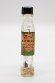
Kuraburn bottle
... AND / SUNBURN / THE SANAX CO. / 849-51 NEPEAN HIGHWAY / MOORABIN / TEL... AND / SUNBURN / THE SANAX CO. / 849-51 NEPEAN HIGHWAY / MOORABIN / TEL ...This Kuraburn Bottle is part of a Sanax First Aid Case which was used at the the former Carnegie Senior Citizens' Centre. The centre was located at 314 Neerim Road, Carnegie. When the Neerim Road facility closed, its activities were moved to the Carnegie Library and Community Centre. For Occupational Health and Safety reasons, Council no longer maintains first aid kits at senior citizens' centres. Clear glass bottle with two paper labels on narrow side. One red, green, white and black label with Sanax branding, one red and white label at base of bottle with address and contact details. Black plastic screw-top lid with a section missing. Bottle has been decanted however some residue remains. Small cork stopper contained within bottle."Sanax" KURABURN / FOR THE TREATMENT / OF BURNS / SCALDS AND / SUNBURN / THE SANAX CO. / 849-51 NEPEAN HIGHWAY / MOORABIN / TEL XU 2651 / Left side of label: Directions: Dab on lightly, and repeat in two hours if necessary. Applied early, it prevents blistering. Right side of label: Allow to dry on the skin before putting on wearing apparel, to avoid staining the clothes. 223-5 BAY ROAD, / SANDRINGHAM, S.8 / VICTORIA / Phone: 98-1604 -
 City of Moorabbin Historical Society (Operating the Box Cottage Museum)
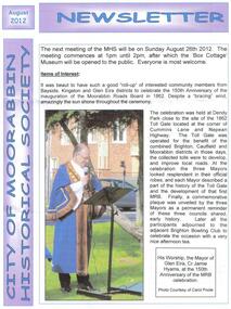
Newsletter - City of Moorabbin Historical Society Aug 2012, August 2012
... Road and Nepean Highway near the original site of the 'Toll... at the corner of Cummins Road and Nepean Highway near the original site ...The City of Moorabbin Historical Society was formed c 1960 by a group of Moorabbin area residents who were concerned that the history of the area should be preserved. A good response to a call for items related to the historical area of Moorabbin Shire brought donations of a wide variety of artefacts that are now preserved by the current members of CMHS at Box Cottage Museum. Helen Stanley, Secretary of CMHS, began producing a Newsletter for members in April 2007 to provide current information and well researched items of historical interestHelen Stanley has produced a bi-monthly Newsletter, 2007 - 2013, for the members of the City of Moorabbin Historical Society that contains well researched interesting historical items, notification of upcoming events, current advice from Royal Australian Historical Society , Museums Australia Victoria and activities of Local Historical Societies. The Newsletter is an important record of the activities of the CMHS1 x A4 paper printed on 1 side Issue 28 of the bi-monthly, City of Moorabbin Historical Society Newsletter produced by Society member and Secretary, Mrs Helen Stanley in August 2012 with photographs of the Ceremony celebrating the 150th Anniversary of the formation of The Moorabbin Roads Board. The Mayors of Glen Eira, Kingston and Brighton unveiled a Plaque at the corner of Cummins Road and Nepean Highway near the original site of the 'Toll gate' . Members of each Historical Society were present including past president of CMHS, His Worship the Mayor of Glen Eira Jamie Hyams. Notes of life at Box Cottagec1918 - 1950 by Stefanie Rennick, nee Reitman, that she donated to CMHS. CITY of MOORABBIN HISTORICAL SOCIETY / AUGUST 2012 NEWSLETTER city of moorabbin historical society, stanley helen, melbourne, moorabbin, brighton, cheltenham, ormond, bentleigh, market gardeners, pioneers, early settlers, the moorabbin roads board 1862, city of glen eira, city of kingston, moorabbin shire, parish of moorabbin, brighton east, south brighton, bent tommy, mair william, jessse morleys hotel, box henry, box william, -
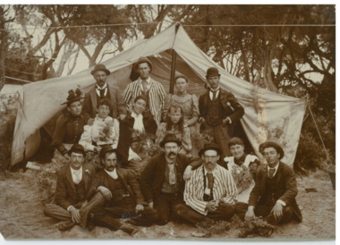
 Chelsea & District Historical Society Inc
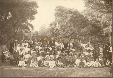
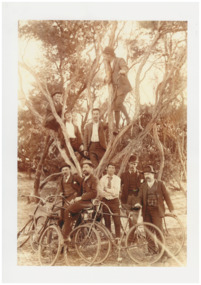
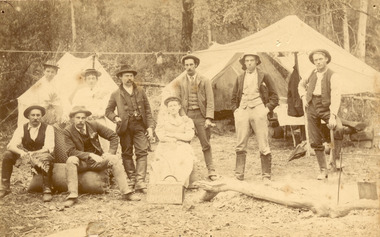
Photograph - Mr Alfred Morton with his brothers and friends, Bike picnic at Morton's property, c 1890
... known as the Nepean Highway) on property that extended from... known as the Nepean Highway) on property that extended from ...Alfred Louis Morton (known as Louis) was born in Geelong in 1866, the fifth of eleven children of Mark Morton and Eliza nee Heard (married 1898). Alfred began work for the Post Office at South Yarra in the 1890s. In the late 1800s it was common for people from Melbourne and north of the city to travel to Chelsea area beaches for their holidays and many liked the area so much that, like the Mortons, they moved here permanently. In the 1890s Alfred’s sister, Mrs William Ashmore, built a weekend house at the foot of what is now Foy Avenue in Chelsea. The Morton family, including Alfred, visited the area often, camping on the foreshore during the 1890s. In 1911 Alfred moved his family permanently to a house on the corner of Morton Grove and Main Road Chelsea (now known as the Nepean Highway) on property that extended from the main road to the beach. This house was destroyed in the fire of 22 December 1913 which raged amongst the ti-tree on the foreshore between Aspendale and Chelsea. Many buildings were destroyed in this fire. The Argus newspaper reported on Wednesday 24 December that 94 houses were burnt with glowing embers blown a mile and half inland. According to the Argus but for the wide break provided by the Point Nepean Road (now the Nepean Highway) and the railway line, the scrub on the other side might have caught. The Morton children, Elsa and Ivan, attended Chelsea State School (now Chelsea Primary School) and Mrs Morton was active in the establishment of St Chad’s Church of England in Chelsea. At the age of 80 in 1945 Mr Morton was concerned about reports that English children had lost their toys due to the war and so he made (as part of a wider effort in Australia) 100 toy engines that were sent to England. He died in 1946 in Chelsea. Sepia photograph of Mr Alfred Morton with his brothers in law and friend at Carrum in the 1890's, some perched in a tree others grouped at the base of the tree, bikes in the foreground.bike riding, picnic, morton, morton grove, chelsea, carrum -
 Chelsea & District Historical Society Inc
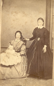
Photograph - Morton Family, Mr Alfred Morton with his mother and aunt, c 1866
... known as the Nepean Highway) on property that extended from... known as the Nepean Highway) on property that extended from ...Alfred Louis Morton (known as Louis) was born in Geelong in 1866, the fifth of eleven children of Mark Morton and Eliza nee Heard (married 1898). Alfred began work for the Post Office at South Yarra in the 1890s. In the late 1800s it was common for people from Melbourne and north of the city to travel to Chelsea area beaches for their holidays and many liked the area so much that, like the Mortons, they moved here permanently. In the 1890s Alfred’s sister, Mrs William Ashmore, built a weekend house at the foot of what is now Foy Avenue in Chelsea. The Morton family, including Alfred, visited the area often, camping on the foreshore during the 1890s. In 1911 Alfred moved his family permanently to a house on the corner of Morton Grove and Main Road Chelsea (now known as the Nepean Highway) on property that extended from the main road to the beach. This house was destroyed in the fire of 22 December 1913 which raged amongst the ti-tree on the foreshore between Aspendale and Chelsea. Many buildings were destroyed in this fire. The Argus newspaper reported on Wednesday 24 December that 94 houses were burnt with glowing embers blown a mile and half inland. According to the Argus but for the wide break provided by the Point Nepean Road (now the Nepean Highway) and the railway line, the scrub on the other side might have caught. The Morton children, Elsa and Ivan, attended Chelsea State School (now Chelsea Primary School) and Mrs Morton was active in the establishment of St Chad’s Church of England in Chelsea. At the age of 80 in 1945 Mr Morton was concerned about reports that English children had lost their toys due to the war and so he made (as part of a wider effort in Australia) 100 toy engines that were sent to England. He died in 1946 in Chelsea. Sepia photograph of Mr Alfred Morton as a baby, on the lap of his mother, Eliza, sitting on a chair, and his aunt, standing.morton, mr alfred louis morton -
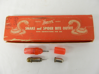 Kiewa Valley Historical Society
Box First Aid, Snake and Spider Outfit, Circa 1940's
... " underneath "Nepean Highway Morabbin" The later printing has been... and spider bite outfit" underneath "Nepean Highway Morabbin ...At the time of manufacture, circa 1940's, the first aid treatment for snake bites, was to lance(cut) open the bite, wash it out and apply a ligature or tourniquet between the bite and the heart. This method was abandoned later after scientific evidence suggested that it was better to stop the blood system from carrying the poison to the heart (pressure immobilization). Australian snakes do not have long fangs therefore deep incisions into main arteries is rare. This research took many years to develop therefore the information supplied with the "Sanax" kits of this era is well outdated. Rural areas were more attuned to the possibilities of snake activity on farms, in sheds and in out houses and farm homesteads. This was not the case for mainly city and large townships environments. The mice plagues in wheat areas during the warmer month s has always been a high risk time for encountering snakesThese snake bite kits were issued to workers on the Kiewa Hydro Electricity Scheme. Some of these snake bite kits were kept at doctor's surgeries e.g. Bogong Village, House 13. The kit was carried by bushwalkers, scouts, farmers and high plains cattlemen. This item is of significance because it demonstrates the main dangers faced by all rural industries and towns, especially remote areas, and the portable remedies that where required as a necessity of the Australian bush environment. This item was in use at a time when the air ambulance and rescue facilities were not in existence and remote locations were more isolated and the availability of anti venom was hard to obtain locally.This item is a red coloured cardboard box(250 - 300 g/m) with white writing and containing the following 12 items. 7 clear red coloured capsules, 2 opaque red plastic capsules, 2 wooden capsules and 1 brass screw on capsule. The capsules are divided into two sections (compartments) horizontally. Each compartment has a screw lid. One compartment contains a lancet (for piercing the snake bite) and the other compartment contains the "Condy's" crystals compete with tightly rolled instructions.On top of the pull up lid, and flanked by two coiled snakes (at the strike position) is printed: "Trade Sanax Mark" below this " SNAKE and SPIDER BITE OUTFIT" and below this with instructions for use". Front side: "Sanax snake and spider bite outfit" underneath "Nepean Highway Morabbin" The later printing has been severely scratched but decipherable. The back side of the box has "Note to the retailer" and due to wear no more of the writing can be read. Each side of the box is printed "SANAX" snake, spider, first aid, kiewa hydro scheme, portable medical supplies -
 Melbourne Tram Museum
Poster, Melbourne & Metropolitan Tramways Board (MMTB), "Increase in Fares", "Scholars' Concession Tickets", 1971
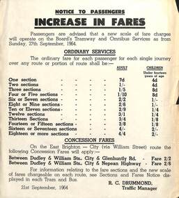
... either Glenhuntly Road and Nepean Highway. Question... either Glenhuntly Road and Nepean Highway. Question ....1 - Poster - printed - as a notice to passengers, titled "Increase in Fares", dated 21/9/1964, signed R C Drummond advising of new fares from 27/9/1964 on buses and trams. Advises of concession fares for the East Brighton - City via William St via either Glenhuntly Road and Nepean Highway. Question - was this poster depot specific, given the advice of the concession fares. .2 - similar document issues for 29/8/1071, but that Scholar's Concession tickets will apply form the 1st term 1972. .3 - similar document, but printed in red ink titled "Scholars' Concession Tickets", notes fare increase of August 1971 and gives prices. Dated November 1971. Addressed to the Parents.trams, tramways, fares, tickets, concession fares, scholar's tickets -
 Chelsea & District Historical Society Inc
Photograph - Camping at Carrum, Morton Family, c 1890's
... known as the Nepean Highway) on property that extended from... known as the Nepean Highway) on property that extended from ...Mr Alfred Morton with his sisters, brothers and friends camping at Carrum in the 1890's. This area was later called Chelsea. Alfred Louis Morton (known as Louis) was born in Geelong in 1866, the fifth of eleven children of Mark Morton and Eliza nee Heard (married 1898). Alfred began work for the Post Office at South Yarra in the 1890s. In the late 1800s it was common for people from Melbourne and north of the city to travel to Chelsea area beaches for their holidays and many liked the area so much that, like the Mortons, they moved here permanently. In the 1890s Alfred’s sister, Mrs William Ashmore, built a weekend house at the foot of what is now Foy Avenue in Chelsea. The Morton family, including Alfred, visited the area often, camping on the foreshore during the 1890s. In 1911 Alfred moved his family permanently to a house on the corner of Morton Grove and Main Road Chelsea (now known as the Nepean Highway) on property that extended from the main road to the beach. This house was destroyed in the fire of 22 December 1913 which raged amongst the ti-tree on the foreshore between Aspendale and Chelsea. Many buildings were destroyed in this fire. The Argus newspaper reported on Wednesday 24 December that 94 houses were burnt with glowing embers blown a mile and half inland. According to the Argus but for the wide break provided by the Point Nepean Road (now the Nepean Highway) and the railway line, the scrub on the other side might have caught. The Morton children, Elsa and Ivan, attended Chelsea State School (now Chelsea Primary School) and Mrs Morton was active in the establishment of St Chad’s Church of England in Chelsea. At the age of 80 in 1945 Mr Morton was concerned about reports that English children had lost their toys due to the war and so he made (as part of a wider effort in Australia) 100 toy engines that were sent to England. He died in 1946 in Chelsea.Sepia photo of members of the Morton family camping at Carrum (now Chelsea). Tents and a wagon in the backgroundmorton, chelsea, carrum, post office, south yarra, camping, tents, wagon -
 Chelsea & District Historical Society Inc
Photograph - South Yarra Post Office, Group of Postal workers, c 1910's
... known as the Nepean Highway) on property that extended from... known as the Nepean Highway) on property that extended from ...Mr Alfred Morton with his sisters, brothers and friends camping at Carrum in the 1890's. This area was later called Chelsea. Alfred Louis Morton (known as Louis) was born in Geelong in 1866, the fifth of eleven children of Mark Morton and Eliza nee Heard (married 1898). Alfred began work for the Post Office at South Yarra in the 1890s. In the late 1800s it was common for people from Melbourne and north of the city to travel to Chelsea area beaches for their holidays and many liked the area so much that, like the Mortons, they moved here permanently. In the 1890s Alfred’s sister, Mrs William Ashmore, built a weekend house at the foot of what is now Foy Avenue in Chelsea. The Morton family, including Alfred, visited the area often, camping on the foreshore during the 1890s. In 1911 Alfred moved his family permanently to a house on the corner of Morton Grove and Main Road Chelsea (now known as the Nepean Highway) on property that extended from the main road to the beach. This house was destroyed in the fire of 22 December 1913 which raged amongst the ti-tree on the foreshore between Aspendale and Chelsea. Many buildings were destroyed in this fire. The Argus newspaper reported on Wednesday 24 December that 94 houses were burnt with glowing embers blown a mile and half inland. According to the Argus but for the wide break provided by the Point Nepean Road (now the Nepean Highway) and the railway line, the scrub on the other side might have caught. The Morton children, Elsa and Ivan, attended Chelsea State School (now Chelsea Primary School) and Mrs Morton was active in the establishment of St Chad’s Church of England in Chelsea. At the age of 80 in 1945 Mr Morton was concerned about reports that English children had lost their toys due to the war and so he made (as part of a wider effort in Australia) 100 toy engines that were sent to England. He died in 1946 in Chelsea.Black and white photo of postal works in front of the South Yarra Post Office. Members of the Morton family are in the group.morton, chelsea, carrum, post office, south yarra, postal workers -
 Chelsea & District Historical Society Inc
Photograph - Camping at Carrum, Morton Family, c 1890's
... known as the Nepean Highway) on property that extended from... known as the Nepean Highway) on property that extended from ...Mr Alfred Morton with his sisters, brothers and friends camping at Carrum in the 1890's. This area was later called Chelsea. Alfred Louis Morton (known as Louis) was born in Geelong in 1866, the fifth of eleven children of Mark Morton and Eliza nee Heard (married 1898). Alfred began work for the Post Office at South Yarra in the 1890s. In the late 1800s it was common for people from Melbourne and north of the city to travel to Chelsea area beaches for their holidays and many liked the area so much that, like the Mortons, they moved here permanently. In the 1890s Alfred’s sister, Mrs William Ashmore, built a weekend house at the foot of what is now Foy Avenue in Chelsea. The Morton family, including Alfred, visited the area often, camping on the foreshore during the 1890s. In 1911 Alfred moved his family permanently to a house on the corner of Morton Grove and Main Road Chelsea (now known as the Nepean Highway) on property that extended from the main road to the beach. This house was destroyed in the fire of 22 December 1913 which raged amongst the ti-tree on the foreshore between Aspendale and Chelsea. Many buildings were destroyed in this fire. The Argus newspaper reported on Wednesday 24 December that 94 houses were burnt with glowing embers blown a mile and half inland. According to the Argus but for the wide break provided by the Point Nepean Road (now the Nepean Highway) and the railway line, the scrub on the other side might have caught. The Morton children, Elsa and Ivan, attended Chelsea State School (now Chelsea Primary School) and Mrs Morton was active in the establishment of St Chad’s Church of England in Chelsea. At the age of 80 in 1945 Mr Morton was concerned about reports that English children had lost their toys due to the war and so he made (as part of a wider effort in Australia) 100 toy engines that were sent to England. He died in 1946 in Chelsea.Sepia photo of members of the Morton family camping at Carrum (now Chelsea).morton, chelsea, carrum, post office, south yarra, camping, tents -
 Chelsea & District Historical Society Inc
Photograph - Morton Family, Morton's house, Chlesea, pre 1913's
... known as the Nepean Highway) on property that extended from... known as the Nepean Highway) on property that extended from ...Mr Alfred Morton with his sisters, brothers and friends camping at Carrum in the 1890's. This area was later called Chelsea. Alfred Louis Morton (known as Louis) was born in Geelong in 1866, the fifth of eleven children of Mark Morton and Eliza nee Heard (married 1898). Alfred began work for the Post Office at South Yarra in the 1890s. In the late 1800s it was common for people from Melbourne and north of the city to travel to Chelsea area beaches for their holidays and many liked the area so much that, like the Mortons, they moved here permanently. In the 1890s Alfred’s sister, Mrs William Ashmore, built a weekend house at the foot of what is now Foy Avenue in Chelsea. The Morton family, including Alfred, visited the area often, camping on the foreshore during the 1890s. In 1911 Alfred moved his family permanently to a house on the corner of Morton Grove and Main Road Chelsea (now known as the Nepean Highway) on property that extended from the main road to the beach. This house was destroyed in the fire of 22 December 1913 which raged amongst the ti-tree on the foreshore between Aspendale and Chelsea. Many buildings were destroyed in this fire. The Argus newspaper reported on Wednesday 24 December that 94 houses were burnt with glowing embers blown a mile and half inland. According to the Argus but for the wide break provided by the Point Nepean Road (now the Nepean Highway) and the railway line, the scrub on the other side might have caught. The Morton children, Elsa and Ivan, attended Chelsea State School (now Chelsea Primary School) and Mrs Morton was active in the establishment of St Chad’s Church of England in Chelsea. At the age of 80 in 1945 Mr Morton was concerned about reports that English children had lost their toys due to the war and so he made (as part of a wider effort in Australia) 100 toy engines that were sent to England. He died in 1946 in Chelsea.Sepia photo of Mr Alfred Morton and his friend, Mr Doug Campbell at his holiday house, in what was to become Morton Grove, Chelsea. morton, chelsea, carrum, morton grove, holiday house -
 Chelsea & District Historical Society Inc
Photograph - Morton Family, Mrs Williams house in Foy Avenue, Chelsea, c 1890's
... known as the Nepean Highway) on property that extended from... known as the Nepean Highway) on property that extended from ...Mr Alfred Morton with his sisters, brothers and friends camping at Carrum in the 1890's. This area was later called Chelsea. Alfred Louis Morton (known as Louis) was born in Geelong in 1866, the fifth of eleven children of Mark Morton and Eliza nee Heard (married 1898). Alfred began work for the Post Office at South Yarra in the 1890s. In the late 1800s it was common for people from Melbourne and north of the city to travel to Chelsea area beaches for their holidays and many liked the area so much that, like the Mortons, they moved here permanently. In the 1890s Alfred’s sister, Mrs William Ashmore, built a weekend house at the foot of what is now Foy Avenue in Chelsea. The Morton family, including Alfred, visited the area often, camping on the foreshore during the 1890s. In 1911 Alfred moved his family permanently to a house on the corner of Morton Grove and Main Road Chelsea (now known as the Nepean Highway) on property that extended from the main road to the beach. This house was destroyed in the fire of 22 December 1913 which raged amongst the ti-tree on the foreshore between Aspendale and Chelsea. Many buildings were destroyed in this fire. The Argus newspaper reported on Wednesday 24 December that 94 houses were burnt with glowing embers blown a mile and half inland. According to the Argus but for the wide break provided by the Point Nepean Road (now the Nepean Highway) and the railway line, the scrub on the other side might have caught. The Morton children, Elsa and Ivan, attended Chelsea State School (now Chelsea Primary School) and Mrs Morton was active in the establishment of St Chad’s Church of England in Chelsea. At the age of 80 in 1945 Mr Morton was concerned about reports that English children had lost their toys due to the war and so he made (as part of a wider effort in Australia) 100 toy engines that were sent to England. He died in 1946 in Chelsea.Sepia photo of members of the Morton family on the verandah of Mrs William's house, Foy Avenue Chelsea.morton, chelsea, carrum, verandah, mrs williams -
 Chelsea & District Historical Society Inc
Photograph - Morton Family, After the 1913 fires in Chelsea, c 1913
... known as the Nepean Highway) on property that extended from... known as the Nepean Highway) on property that extended from ...Mr Alfred Morton with his sisters, brothers and friends camping at Carrum in the 1890's. This area was later called Chelsea. Alfred Louis Morton (known as Louis) was born in Geelong in 1866, the fifth of eleven children of Mark Morton and Eliza nee Heard (married 1898). Alfred began work for the Post Office at South Yarra in the 1890s. In the late 1800s it was common for people from Melbourne and north of the city to travel to Chelsea area beaches for their holidays and many liked the area so much that, like the Mortons, they moved here permanently. In the 1890s Alfred’s sister, Mrs William Ashmore, built a weekend house at the foot of what is now Foy Avenue in Chelsea. The Morton family, including Alfred, visited the area often, camping on the foreshore during the 1890s. In 1911 Alfred moved his family permanently to a house on the corner of Morton Grove and Main Road Chelsea (now known as the Nepean Highway) on property that extended from the main road to the beach. This house was destroyed in the fire of 22 December 1913 which raged amongst the ti-tree on the foreshore between Aspendale and Chelsea. Many buildings were destroyed in this fire. The Argus newspaper reported on Wednesday 24 December that 94 houses were burnt with glowing embers blown a mile and half inland. According to the Argus but for the wide break provided by the Point Nepean Road (now the Nepean Highway) and the railway line, the scrub on the other side might have caught. The Morton children, Elsa and Ivan, attended Chelsea State School (now Chelsea Primary School) and Mrs Morton was active in the establishment of St Chad’s Church of England in Chelsea. At the age of 80 in 1945 Mr Morton was concerned about reports that English children had lost their toys due to the war and so he made (as part of a wider effort in Australia) 100 toy engines that were sent to England. He died in 1946 in Chelsea.Sepia photo of members of the Morton family sitting on their land after the fires in Chelsea, 1913.morton, chelsea, carrum, verandah, fires -
 Chelsea & District Historical Society Inc
Photograph - Mr Morton in uniform, late 1880's
... known as the Nepean Highway) on property that extended from... known as the Nepean Highway) on property that extended from ...Mr Alfred Morton with his sisters, brothers and friends camping at Carrum in the 1890's. This area was later called Chelsea. Alfred Louis Morton (known as Louis) was born in Geelong in 1866, the fifth of eleven children of Mark Morton and Eliza nee Heard (married 1898). Alfred began work for the Post Office at South Yarra in the 1890s. In the late 1800s it was common for people from Melbourne and north of the city to travel to Chelsea area beaches for their holidays and many liked the area so much that, like the Mortons, they moved here permanently. In the 1890s Alfred’s sister, Mrs William Ashmore, built a weekend house at the foot of what is now Foy Avenue in Chelsea. The Morton family, including Alfred, visited the area often, camping on the foreshore during the 1890s. In 1911 Alfred moved his family permanently to a house on the corner of Morton Grove and Main Road Chelsea (now known as the Nepean Highway) on property that extended from the main road to the beach. This house was destroyed in the fire of 22 December 1913 which raged amongst the ti-tree on the foreshore between Aspendale and Chelsea. Many buildings were destroyed in this fire. The Argus newspaper reported on Wednesday 24 December that 94 houses were burnt with glowing embers blown a mile and half inland. According to the Argus but for the wide break provided by the Point Nepean Road (now the Nepean Highway) and the railway line, the scrub on the other side might have caught. The Morton children, Elsa and Ivan, attended Chelsea State School (now Chelsea Primary School) and Mrs Morton was active in the establishment of St Chad’s Church of England in Chelsea. At the age of 80 in 1945 Mr Morton was concerned about reports that English children had lost their toys due to the war and so he made (as part of a wider effort in Australia) 100 toy engines that were sent to England. He died in 1946 in Chelsea.Sepia photo Mr Morton in Fireman Uniformmorton, chelsea, carrum, fireman uniform -
 Chelsea & District Historical Society Inc
Photograph - South Yarra Post Office, Group of Postal workers
... known as the Nepean Highway) on property that extended from... known as the Nepean Highway) on property that extended from ...Mr Alfred Morton with his sisters, brothers and friends camping at Carrum in the 1890's. This area was later called Chelsea. Alfred Louis Morton (known as Louis) was born in Geelong in 1866, the fifth of eleven children of Mark Morton and Eliza nee Heard (married 1898). Alfred began work for the Post Office at South Yarra in the 1890s. In the late 1800s it was common for people from Melbourne and north of the city to travel to Chelsea area beaches for their holidays and many liked the area so much that, like the Mortons, they moved here permanently. In the 1890s Alfred’s sister, Mrs William Ashmore, built a weekend house at the foot of what is now Foy Avenue in Chelsea. The Morton family, including Alfred, visited the area often, camping on the foreshore during the 1890s. In 1911 Alfred moved his family permanently to a house on the corner of Morton Grove and Main Road Chelsea (now known as the Nepean Highway) on property that extended from the main road to the beach. This house was destroyed in the fire of 22 December 1913 which raged amongst the ti-tree on the foreshore between Aspendale and Chelsea. Many buildings were destroyed in this fire. The Argus newspaper reported on Wednesday 24 December that 94 houses were burnt with glowing embers blown a mile and half inland. According to the Argus but for the wide break provided by the Point Nepean Road (now the Nepean Highway) and the railway line, the scrub on the other side might have caught. The Morton children, Elsa and Ivan, attended Chelsea State School (now Chelsea Primary School) and Mrs Morton was active in the establishment of St Chad’s Church of England in Chelsea. At the age of 80 in 1945 Mr Morton was concerned about reports that English children had lost their toys due to the war and so he made (as part of a wider effort in Australia) 100 toy engines that were sent to England. He died in 1946 in Chelsea.Sepia photo of nine postal workers at South Yarra Post Office. They are wearing hats each with a different number, some have postal bags and some with letters in their hands. Mr Morton is the only one not wearing a hat.morton, chelsea, carrum, post office, south yarra, postal workers, postal uniform -
 Chelsea & District Historical Society Inc
Photograph - South Yarra Post Office, Postal workers
... known as the Nepean Highway) on property that extended from... known as the Nepean Highway) on property that extended from ...Mr Alfred Morton with his sisters, brothers and friends camping at Carrum in the 1890's. This area was later called Chelsea. Alfred Louis Morton (known as Louis) was born in Geelong in 1866, the fifth of eleven children of Mark Morton and Eliza nee Heard (married 1898). Alfred began work for the Post Office at South Yarra in the 1890s. In the late 1800s it was common for people from Melbourne and north of the city to travel to Chelsea area beaches for their holidays and many liked the area so much that, like the Mortons, they moved here permanently. In the 1890s Alfred’s sister, Mrs William Ashmore, built a weekend house at the foot of what is now Foy Avenue in Chelsea. The Morton family, including Alfred, visited the area often, camping on the foreshore during the 1890s. In 1911 Alfred moved his family permanently to a house on the corner of Morton Grove and Main Road Chelsea (now known as the Nepean Highway) on property that extended from the main road to the beach. This house was destroyed in the fire of 22 December 1913 which raged amongst the ti-tree on the foreshore between Aspendale and Chelsea. Many buildings were destroyed in this fire. The Argus newspaper reported on Wednesday 24 December that 94 houses were burnt with glowing embers blown a mile and half inland. According to the Argus but for the wide break provided by the Point Nepean Road (now the Nepean Highway) and the railway line, the scrub on the other side might have caught. The Morton children, Elsa and Ivan, attended Chelsea State School (now Chelsea Primary School) and Mrs Morton was active in the establishment of St Chad’s Church of England in Chelsea. At the age of 80 in 1945 Mr Morton was concerned about reports that English children had lost their toys due to the war and so he made (as part of a wider effort in Australia) 100 toy engines that were sent to England. He died in 1946 in Chelsea.Sepia photo of postal workers at South Yarra Post Office, corner of Toorak Road and Osborne Street, South Yarra. Mr Morton is standing at the counter, other workers are in the background .morton, chelsea, carrum, post office, south yarra, postal workers, postal uniform -
 Chelsea & District Historical Society Inc
Photograph - South Yarra Post Office
... known as the Nepean Highway) on property that extended from... known as the Nepean Highway) on property that extended from ...Mr Alfred Morton with his sisters, brothers and friends camping at Carrum in the 1890's. This area was later called Chelsea. Alfred Louis Morton (known as Louis) was born in Geelong in 1866, the fifth of eleven children of Mark Morton and Eliza nee Heard (married 1898). Alfred began work for the Post Office at South Yarra in the 1890s. In the late 1800s it was common for people from Melbourne and north of the city to travel to Chelsea area beaches for their holidays and many liked the area so much that, like the Mortons, they moved here permanently. In the 1890s Alfred’s sister, Mrs William Ashmore, built a weekend house at the foot of what is now Foy Avenue in Chelsea. The Morton family, including Alfred, visited the area often, camping on the foreshore during the 1890s. In 1911 Alfred moved his family permanently to a house on the corner of Morton Grove and Main Road Chelsea (now known as the Nepean Highway) on property that extended from the main road to the beach. This house was destroyed in the fire of 22 December 1913 which raged amongst the ti-tree on the foreshore between Aspendale and Chelsea. Many buildings were destroyed in this fire. The Argus newspaper reported on Wednesday 24 December that 94 houses were burnt with glowing embers blown a mile and half inland. According to the Argus but for the wide break provided by the Point Nepean Road (now the Nepean Highway) and the railway line, the scrub on the other side might have caught. The Morton children, Elsa and Ivan, attended Chelsea State School (now Chelsea Primary School) and Mrs Morton was active in the establishment of St Chad’s Church of England in Chelsea. At the age of 80 in 1945 Mr Morton was concerned about reports that English children had lost their toys due to the war and so he made (as part of a wider effort in Australia) 100 toy engines that were sent to England. He died in 1946 in Chelsea.Sepia photo of South Yarra Post Office, corner of Toorak Road and Osborne Street, South Yarra. Mr Morton and three other postal workers are standing at the front.morton, chelsea, carrum, post office, south yarra, postal workers, postal uniform -
 Chelsea & District Historical Society Inc
Photograph - Group of people camping at Carrum (Chelsea), c 1890
... known as the Nepean Highway) on property that extended from... known as the Nepean Highway) on property that extended from ...Mr Alfred Morton with his sisters, brothers and friends camping at Carrum in the 1890's. This area was later called Chelsea. Alfred Louis Morton (known as Louis) was born in Geelong in 1866, the fifth of eleven children of Mark Morton and Eliza nee Heard (married 1898). Alfred began work for the Post Office at South Yarra in the 1890s. In the late 1800s it was common for people from Melbourne and north of the city to travel to Chelsea area beaches for their holidays and many liked the area so much that, like the Mortons, they moved here permanently. In the 1890s Alfred’s sister, Mrs William Ashmore, built a weekend house at the foot of what is now Foy Avenue in Chelsea. The Morton family, including Alfred, visited the area often, camping on the foreshore during the 1890s. In 1911 Alfred moved his family permanently to a house on the corner of Morton Grove and Main Road Chelsea (now known as the Nepean Highway) on property that extended from the main road to the beach. This house was destroyed in the fire of 22 December 1913 which raged amongst the ti-tree on the foreshore between Aspendale and Chelsea. Many buildings were destroyed in this fire. The Argus newspaper reported on Wednesday 24 December that 94 houses were burnt with glowing embers blown a mile and half inland. According to the Argus but for the wide break provided by the Point Nepean Road (now the Nepean Highway) and the railway line, the scrub on the other side might have caught. The Morton children, Elsa and Ivan, attended Chelsea State School (now Chelsea Primary School) and Mrs Morton was active in the establishment of St Chad’s Church of England in Chelsea. At the age of 80 in 1945 Mr Morton was concerned about reports that English children had lost their toys due to the war and so he made (as part of a wider effort in Australia) 100 toy engines that were sent to England. He died in 1946 in Chelsea.Sepia photograph of a of Mr Alfred Morton with his sisters, brothers and friends camping at Carrum in the 1890's. bike riding, picnic, morton, morton grove, chelsea, carrum, camping -
 City of Kingston
Photograph - Black and white, 20 December 1945
... ), McIvor Street, Goulburn Street, Nepean Highway, Jamieson Street... Street, Nepean Highway, Jamieson Street and Barker Street (bottom ...Cheltenham is a suburb in the City of Kingston that was originally established as a rural market gardening community. The area is bordered by Highett, Mentone and Heatherton. The market gardens, farms and paddocks have gradually been sub-divided into housing and industrial estates. The Southland shopping centre is a major feature of the area.Cheltenham was established as a rural market gardening community. The Le Page family lived in Cheltenham since 1854 when Nicholas Le Page, a tailor from the Channel Island of Guernsey, bought two acres of land on Chesterville Road near Bernard Street to establish a market garden. Over the years the Le Pages purchased more land in the area. In 1875-76 Nicholas' son Frank and his wife Mary built 'Daphne Cottage' near the corner of Bernard and Wilson Streets. n the 1940s Frank's son, Everest Le Page, bought five more lots of land in Chesterville Road from the Tuck family. The Le Pages grazed horses, ponies and cows on this land, and grew pumpkins, carrots, parsnips, onions, potatoes and cabbages. Many buildings and locations within in Cheltenham commemorate the Le Page family's contribution to the Cheltenham community.Aerial photograph taken in 1945 of the Cheltenham district within the City of Kingston. The image includes Chesterville Road, the future site of Turner Road pool (now Waves) and Highett Reserve, (top left), Jellicoe Street, Argus Street, Bernard Street, Wilson Street, the Methodist Children Homes (now Southland), McIvor Street, Goulburn Street, Nepean Highway, Jamieson Street and Barker Street (bottom left), market gardens and paddocks. In the top centre of the image, "Daphne Cottage", the home of Frank T. Le Page is visible on the corner of Bernard and Wilson Streets. Much of the land depicted in this image was owned by the Le Page family. This image is possibly from the collection of aerial photographs commissioned by the Department of Crown Lands and Survey and taken by Adastra Airways.Black and white ink: 57250 White print: VIC-170 57250 20.12.45 Run 6 PROJ. No. 5 MELB. METROP AREA Black type 10200 FTS 30' LENS 20.12.45cheltenham, market gardens, industry, le page family