Showing 2652 items
matching place name
-
 Federation University Historical Collection
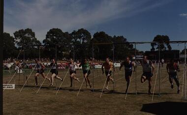
Photograph - Photograph - coloured, University of Ballarat, Arthur Postle 70 metre Handicap
... Arthur Postle Handicap Race at Stawell. The names and placings...Typed slip attached with names of competitors, placings... Postle Handicap Race at Stawell. The names and placings ...Photograph shows the finish of the University of Ballarat Arthur Postle Handicap Race at Stawell. The names and placings are indicated with the photograph. Born on March 8, 1881, at Pittsworth on the Darling Downs, Queensland, Postle was crowned the world’s fastest man in 1906 and won the 220 Yard World Champion Cup in 1909. Coloured photograph framed in dark brown folderTyped slip attached with names of competitors, placings and time of event arthur postle, handicap race, stawell, university of ballarat, h brycki, r smith, e evelyn, a smith, j noble, k mcguigan, s baird, j macgibbon -
 Warrnambool and District Historical Society Inc.
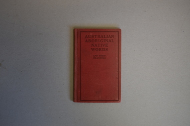
Book, Australian Aboriginal Native Words and Their Meanings, 1925
... as place or house names in Australia. A variety of sources was used...' with the suggestion that they could be used as place or house names ...Aboriginal words and their English meaningsThis is a book of 48 pages. It has a red cover with black printing. The pages contain printed material and black and white photographs.non-fictionAboriginal words and their English meaningsaustralian aboriginal words and their meaning -
 Melton City Libraries
Map, Streets of Melton, 1963
... ? Alphabetical List Aboriginal place names, Early Family Names...? Alphabetical List Aboriginal place names, Early Family Names ...MELTON’S STREETS Heritage Week 2014 What’s in a Name? Alphabetical List Aboriginal place names, Early Family Names and landowners, Agricultural, Shop and Commercial premises, Places and Events Melton & District Historical Society Street Naming Project 1972 – c 1998 Suburb Name – KURUNJANG - Kirkton, 1972, Brookfield, West, 1988 Melton and Town Centre - A joint collaboration with the Shire of Melton and Subdivision Developers ARNOLD Court – Family house - Arnolds Creek ALKEMADE Drive Family – Lime kilns Coimadia ALEXANDRA Street 1902 – Corination of King Edward VII and Queen Alexandra AVIATOR Place Event, location of plane crash – Jimmy Melrose 1936 Adina ?Annibee - Anniba? Agricultural Avon court .. .. BAKERY Square - Location of Jongebloed shop, bakehouse and stables BALUK Place Aboriginal BARLEYCORN Place Agricultural BILLING Place Name of Jimmy Melrose Uncle Noel Pemberton Billing BLACKWOOD Drive - Alexander Blackwood 1860c Registrar BARRIES Road C. E. Barrie “Darlingsford” farmer 1911, chaff mill owner BROOKLYN Road Staughton family residence. 1875 – Dismantled c 193? CAHILL Drive Family - Glenville Dairy CAMERON Court Family Canopus Place ? CANALLAN Drive Early Surveyor CAMPBELL Court Aviation – Melrose passenger 6th July 1936 CARBERRY Drive Michael, early landowner family CAREW Court Edward and Michael. Royal Hotel. Vera (Carew) Forran Singer - Opera CASEY Court Family CASHIN Court Family CHEVIOT Court Agriculture, breed of sheep CHESNEY Road was re named ( Minns Road being duplicated c 1973) CHRISTINA Crescent Christina McPherson, daughter of James and Mary Mary McPherson. Died 1955 aged 85 years COLLYER Close a deleted street (parallel to Yuille) re-used CORRIEDALE Road Breed of sheep CORR Court Teacher at first school, landowner CROXTON Court Name of the Hornbuckle and Knox family home DALEY Court - William Daley and family 1865 Bootmaker High Street DARLINGSFORD Boulevard - Name of early homestead Thomas B Darling 1853 DJERRIWARRH Court - Parish County of Bourke - very early map. DODEMAIDE Place Early land owners - Melton Football Team had 6 brothers playing c 1924 DONALD Court McPherson family 6 generations in Melton in 1936 DOUGAL Court DUNCAN Court .. .. DUNVEGAN Circuit Home of the McPherson family, castle Isle of Skye Name of bluestone house Smith Street (now at Willows) EMIL Court Jongebloed family EXELL Avenue Farming family Melton Sth- Closer Settlement 1907 EXFORD Road Exe former name of the Werribee river FARMER Court Name of early postmistress FERRIS Road John Ferris Farmer HANNAH Close First name of Hannah Watts – midwife HAYBALE Place Agricultural HELDER Court Early surveyor J Helder Wedge map HEWSON Street Winston Hewson Shire Engineer – check title c 1960 HENRY Street Township map c 1860 HESTON Street Heston Phoenix – C.J. Melrose plane HILDEGARDE Court Jimmy Melrose’s mothers name HOMESTEAD Close HORNBUCKLE Cres Farmers. Three members of family - Shire Presidents HURLEY Street Farmers IAIN Court Descendent of James and Mary McPherson JAMES MELROSE Drive Name appears on 2013 Melton information map JANG Place KURUN – jang KIRKTON Drive Name of the McPherson family home Toolern Vale Road KIRWIN Street Michael early landowners (deleted for freeway construction) KILPATRICKS Road Deleted when Barries Road was extended across Station Rd KOROROIT Court Early map, Parish of Kororoit. Creek name KNOX Circuit Family – Hornbuckle “Croxton Park” KURRUNJANG Drive Aboriginal name for people of the red earth – Suburb name Lara Place ? LLOYD Court Garage owners High Street. Laura lived to 100 years D 1955 LUBY Court John Luby – Crown Grant Land Title LITTLE Court MANNING Avenue Richard, hotel owner 1891 MARGARET Drive McPherson family McDONALD Street Melton South family name McKENZIE Street Township c1860 MORROW Street Early name MOWBRAY Crescent Name of English Melton, popularly believed origin of Melton MYERS Court Early setters c 1866 Crown Grant Land Title NIMMO Street Early name NIXON Street Name submitted by Mary nee Nixon Collins c1985 OLDERSHAW Road Early builder PALMERSTON Street Early township map c 1860 PEART Court Early name PENNYROYAL Avenue Plant growing by the creek. Early name used for the Toolern Toolam Creek PINKERTON Street Family name and early street map PINNACLE Crescent Agricultural - type of wheat PHOENIX Circuit C.J. Melrose Phoenix Heston Plane 2013 map PRATT Family PRIOR Court PYKE Place Brothers – early settlement 1838 RADFORD Court Land owners and business operators. Former Royal Hotel Grocer High Street demolished 1970 RAGLAN Court Hotel 19th century Lord Raglan RALEIGHS Road Oliver Reierson family (Norweigen) Shopkeeper – Dressmakers RIDDELL Drive (misspelt Riddle) Resident and land owner RODERICK Road McPherson family – a re occurring name ROLLAND Court Jones family ROSS Court Daniel. Landowner. Agnes Ross music teacher RUSSELL Court Robert. Early land surveyor of Melton 1853 RYAN Court Family early landowner. Member of the 1862 Road Board SHEBLER Place Augustus early Melton resident – Golden Fleece Hotel SHEEPFOLD Court Farming SHERWIN Court Sherwin Street earliest Township map– became Golf course SMITH Street Early township map. STRATHULLOH Circuit Strathtulloh Homestead. STAUGHTON Street Family – LARGE land owners Strachan ? SWANEY Court Marie Swaney earlier resident of Strathtulloh. SUTHERLAND Family name TOOLERN Street TOOLAM – TOOLERN Creek TULLIDGE St Road marked on 1861 map UNITT Street Early Township c 1860 WALLACE Square Cr Jack Wallace 5 terms as President 46 years unopposed WATTS Court Hannah Watts – midwife, cottage hospital WALSINGHAM Name of house of Minns family. From Walsingham Norfolk England WESTLEY Place Name of Jimmy Melrose Percival Gull Plane WESTLAKE Drive Early resident WHICKHAM Street Family Name Melton South WILSON Road Albert, Melton South YUILLE Street William Cross, early landowner, Rockbank run Zoomed in section of Melton Streets including Church and High Streetlandscapes of significance -
 Red Cliffs Military Museum
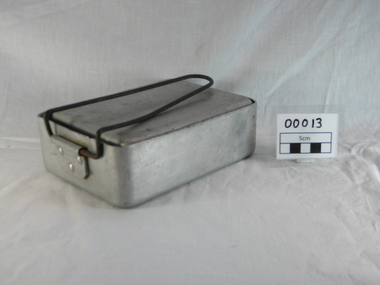
Mess kit, 1939 (exact)
... the Second World War, the mess tins were marked with names of places... the Second World War, the mess tins were marked with names of places ...This is part of a collection donated by Mrs Margaret McKenzie that belonged to her husband and was issued to him during the Second World War, the mess tins were marked with names of places, ships and battle locations. Other items include a postcard sent home in August 1941 and a photo of Australian troops on parade at Wewak in August 1945Aluminium Mess tin set, 2 rectangular tins one smaller to fit into larger. Inscriptions engraved on 4 sides containing locations of training, ships and battle areas. Additional markings include year of manufacture and company along with Department of Defence broad arrow. Item is stamped metal with wire handle on the large tin. Wire carry handle missing on smaller tin. "Inscription on base of mess tin large. 'DARLEY ALBANY/ SYDNEY/ PERTH/ TRINCOMALEE:CEYLON/ PORT TUFIC/ SUEZ CANAL/ EL CANTARA/ GAZA/ JERUSALEM/ HIFA TELAVIV/ BETHALEM/ BAYROUTA/ JUDEDES FIAKE/darwin, world war two, pan set messing, mess tins, aluminium, 2nd aif, 8th battalion, vx52576, pte, mckenzie, c mckenzie, 1939, c b ltd, 1941 1945, 19th australian infantry training battalion, b company, 21st august 1941, finchaven, wandecla, cairns, brisbane -
 Flagstaff Hill Maritime Museum and Village
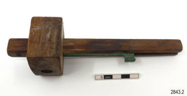
Tool - Marking Gauge
... in place. Inscription with maker's name and almost indecipherable... the sliding arm in place. Inscription with maker's name and almost ...This mortice marking gauge has an adjustable sliding arm. The gauge is used for scribing two lines on a flat surface such as timber for measuring and cutting. It is a hand-powered tool that would have been used by a tradesperson such as a cabinet maker, woodworker or carpenter. The hand tool shows signs of much use. The ‘W. Maples & Sons, Hibernia’s catalogue of 1867 had a very similar tool, called a Mortice Gauge, column 2, page 15. W. MARPLES & SONS- William Marples Snr. had a business on the Sheffield Moor in 1773/74. In 1821 his son William Jnr. At 12 years old began in his father’s joinery business. 1833 the firm was known as a tool manufacturer. In 1838 Marples called his business Hibernian Works and moved to 67-69 Spring Lane, Sheffield. When he moved to Westfield Terrace in 1856, he called his business Hibernia Works (no ‘n’ on the end). The business remained at this address for 116 years. In about 1859 the firm began using the Lyre (Irish harp) mark. In 1860 or so the two brothers, Edwin and William Marples, became partners and the firm became William Marples and Sons. The firm introduced the single shamrock symbol in 1860-61. The boys’ brother Albert joins the firm in 1863. In 1875 the company registered both the name ‘Hibernia’ and the trade mark symbol of a Triple Shamrock and the use of these trademarks continued for many decades, into the 1940 and the firm, with many changes, was still in business in the early 21st century. About Shamrock and Hibernia, both are related to Ireland and W. Marples named his products the Shamrock brand.The marking gauge is an example of a hand powered woodworking tool used over the past few centuries. Its maker was well known for his good quality tools and his business grew because of his reputation.Mortice marking gauge: wooden staff with block and green, adjustable sliding arm within the staff. The end of the staff has a facility for holding the scribe marker. The block has a hole into which a peg or wedge would be inserted to hold the sliding arm in place. Inscription with maker's name and almost indecipherable mark is stamped onto one side of the block. Made by W Marples & Sons, Sheffield.Stamped into block “W. MARPLES & SONS / HIBERNIA WORKS” above Logo of ‘Trefoil’ image [three, three-leafed clovers on the same stem]flagstaff hill, warrnambool, maritime museum, maritime village, shipwreck coast, hand tool, woodwork, marking gauge, measuring tool, mortice gauge, mortice marking gauge, william marples, w marples & sons, hibernia, shamrock, trifoil, tripple shamrock, carpenter's tool, cabinet maker, woodworking tool, drawing, planning, tool, wooden scribe, vintage, carpenter, marking tool, antique, marking out, joiner -
 Ballarat Tramway Museum
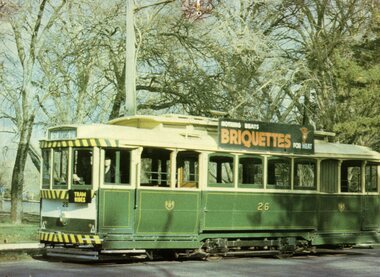
Postcard, Bascands Ltd. Christchurch NZ, SECV 26
... and photographers name, with place for stamp and address. ... name and photographers name, with place for stamp and address ...Colour postcard of SECV Ballarat No. 26, photographed in Wendouree Parade during possibly late 1975 by W.J.Kingsley for the BTPS postcard. Tram has St Aidans Drive destination and "TRAM RIDES" signs. Tram in SECV livery. Has "Nothing Beats Briquettes for heat" advertising board on side. On rear is a note regarding the tram, the BTPS and its operations, printers name and photographers name, with place for stamp and address. trams, tramways, wendouree parade, btps, postcards -
 Kiewa Valley Historical Society
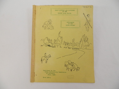
Book - Bogong High Plains x2, Early History and Discovery of the Bogong High Plains, 1968
... of the early history of the Bogong High Plains and the origin of names... of the Bogong High Plains and the origin of names of places and creeks ...The State Electricity Commission of Victoria constructed the Kiewa Hydro Electric Scheme in the north east of Victoria. Mr R.M. Duncan prepared the notes. He was a member of the S.E.C. Kiewa Branch from 1949 - 1966. This book was commissioned by the State Electricity Commission of Victoria. It consists of the early history of the Bogong High Plains and the origin of names of places and creeks in the area.This book was researched in 1968 by Mr R.M. Duncan who worked for the S.E.C. on the Kiewa Hydro Electric Scheme from 1949 to 1966. His sources were the Melbourne Public Library, the Victorian Historical Society, the North Eastern Victorian Historical Society and the Dept. of Crown Lands & Survey, Melbourne. The book is an accurate history of the Bogong High Plains given the available records at the time. Yellow cardboard covered book with black sketches and green print. 9 one-sided pages held together by 3 staples and taped over the staples. One - has sheets enclosed "The Three Floras of Bogong" and "General Geology of the Kiewa Area". 6 copies including 1 that is a photocopyDDTS hand written on front cover "Early History and Discovery / of the / Bogong High Plains" on cover top centre. "Settlement / of the / Kiewa-Valley" on cover towards the top slightly to the right. "Published by the / State Electricity Commission / of Victoria / July, 1968" on cover bottom left. "TR-K 596-4" on cover bottom left.bogong high plains. state electricity commission of victoria. kiewa. aborigines. kiewa valley. mullindollingong pastoral run. flora. geology -
 Tennis Australia
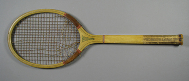
Racquet, Circa 1930
... . Manufacturer name and place of manufacture printed on right side... across throat on reverse. Manufacturer name and place ...A Wright & Ditson 'Championship Mohawk' tennis racquet.String whipping around shoulders and around base of throat. Racquet model name 'MOHAWK' , printed along throat on obverse and model name 'CHAMPIONSHIP' printed across throat on reverse. Manufacturer name and place of manufacture printed on right side of shaft. Octagonal fine-grooved handle , with leather end wrap. Materials: Wood, Metal, Lacquer, Glue, Ink, Leather, Nylon, Stringtennis -
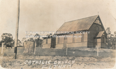
 Eltham District Historical Society Inc
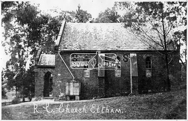
Negative - Photograph, Tom Prior, St Mary's Roman Catholic Church, Eltham, c.1900
... in its place and named Our Lady of Help Christians Church.... in its place and named Our Lady of Help Christians Church ...The original St Mary’s Roman Catholic Church (1865-1912) was built of clay brick with buttress walls and a slate roof on the corner of Fordhams Road and Maria Street (Main Road), Eltham South, opposite the present-day Wingrove Park. It was blessed on September 3, 1865. With the arrival of the railway in 1901 and the town centre moving closer to the station, the decision was made to relocate the site of the church to its present-day location on Henry Street at the corner of Main Road. A new timber weatherboard church, also called St Mary's was erected and blessed on October 13, 1912. The church and land cost £1,400 (Evelyn Observer). The original brick church It was demolished in the 1920s and the bricks and windows were recycled to build a dairy on the Brinkkotter farm at Research. The timber church was destroyed by fire in 1961 and a new modern architectural (1960s) style church was erected in its place and named Our Lady of Help Christians Church.This photo forms part of a collection of photographs gathered by the Shire of Eltham for their centenary project book,"Pioneers and Painters: 100 years of the Shire of Eltham" by Alan Marshall (1971). The collection of over 500 images is held in partnership between Eltham District Historical Society and Yarra Plenty Regional Library (Eltham Library) and is now formally known as the 'The Shire of Eltham Pioneers Photograph Collection.' It is significant in being the first community sourced collection representing the places and people of the Shire's first one hundred years. The Reynolds family were early settlers in Research. The Reynolds/ Prior collection of photographs were taken by Tom Prior, the maternal uncle of Ivy Reynolds, around 1900 and the 60 photos in the album give a fine overview of many of the landmarks of Research and Eltham over 100 years ago. lvy lived in the family home for many years at 106 Thompson Cres Research. Ivy's father, Ernst Richard Reynolds and grandfather, Richard Reynolds, lived at the same address. Ivy's father Richard worked for Mr. Trail on his property in Research. Reynolds Road is named after the family. Mr Tom Prior (wife Eva) worked at the Melbourne zoo. He was very innovative and made his own camera, using the black cloth hood to exclude the light. The photographs are a reminder of the rural nature of Research and Eltham and its rich heritage.Digital image 4 x 5 inch B&W Negsepp, shire of eltham pioneers photograph collection, eltham, roman catholic church, brinkkotter, catholic church, church, reynolds prior collection, st marys catholic church -
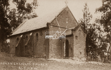
 Eltham District Historical Society Inc
Postcard - Photograph, St Mary's Catholic Church, cnr Main Road and Henry Street, Eltham, c.1912
... in its place and named Our Lady of Help Christians Church.... in its place and named Our Lady of Help Christians Church ...The original St Mary’s Roman Catholic Church (1865-1912) was built of clay brick with buttress walls and a slate roof on the corner of Fordhams Road and Maria Street (Main Road), Eltham South, opposite the present-day Wingrove Park. It was blessed on September 3, 1865. With the arrival of the railway in 1901 and the town centre moving closer to the station, the decision was made to relocate the site of the church to its present-day location on Henry Street at the corner of Main Road. A new timber weatherboard church, also called St Mary's was erected and blessed on October 13, 1912. The church and land cost £1,400 (Evelyn Observer). The original brick church It was demolished in the 1920s and the bricks and windows were recycled to build a dairy on the Brinkkotter farm at Research. The timber church was destroyed by fire in 1961 and a new modern architectural (1960s) style church was erected in its place and named Our Lady of Help Christians Church.PostcardReturn to Garnet Burges, Judge Bookchurches, catholic churches, st marys, main road, henry street, eltham -
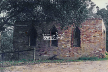 Eltham District Historical Society Inc
Photograph, Old dairy on the Brinkkotter farm, Research, Vic, Jul. 2001
... in its place and named Our Lady of Help Christians Church.... in its place and named Our Lady of Help Christians Church ...The original St Mary’s Roman Catholic Church (1865-1912) was built of clay brick with buttress walls and a slate roof on the corner of Fordhams Road and Maria Street (Main Road), Eltham South, opposite the present-day Wingrove Park. It was blessed on September 3, 1865. With the arrival of the railway in 1901 and the town centre moving closer to the station, the decision was made to relocate the site of the church to its present-day location on Henry Street at the corner of Main Road. A new timber weatherboard church, also called St Mary's was erected and blessed on October 13, 1912. The church and land cost £1,400 (Evelyn Observer). The original brick church was demolished in the 1920s and the bricks and windows were recycled to build a dairy on the Brinkkotter farm at Research. The timber church was destroyed by fire in 1961 and a new modern architectural (1960s) style church was erected in its place and named Our Lady of Help Christians Church.Colour photographresearch (vic.), brinkkotter, catholic church, eltham, roman catholic church, st marys catholic church -
![Cumberland Creek, near Point Sturt / [by] Nicholas Caire, circa 1876](/media/collectors/550653872162f11fb04854aa/items/57834713d0cdd1176c71111b/item-media/57834799d0cdd1176c71e113/item-fit-380x285.jpg) Kew Historical Society Inc
Kew Historical Society IncPhotograph, Anglo-Australasian Photographic Company, Cumberland Creek, near Point Sturt, c. 1876
... the close resemblance it bears to the place bearing that name... to the place bearing that name in the mother country. The present ...Nicholas Caire was born on Guernsey in the Channel Islands in 1837. He arrived in Adelaide with his parents in about 1860. In 1867, following photographic journeys in Gippsland, he opened a studio in Adelaide. From 1870 to 1876 he lived and worked in Talbot in Central Victoria. In 1876 he purchased T. F. Chuck's studios in the Royal Arcade Melbourne. In 1885, following the introduction of dry plate photography, he began a series of landscape series, which were commercially successful. As a photographer, he travelled extensively through Victoria, photographing places few of his contemporaries had previously seen. He died in 1918. Reference: Jack Cato, 'Caire, Nicholas John (1837–1918)', Australian Dictionary of Biography.An original, rare photograph from the series 'Views of Victoria: General Series' by the photographer, Nicholas Caire (1837-1918). The 60 photographs that comprise the series were issued c. 1876 and reinforced a neo-Romantic view of the Australian landscape to which a growing nationalist movement would respond. Nicholas Caire was active as a photographer in Australia from 1858 until his death in 1918. His vision of the Australian bush and pioneer life had a counterpart in the works of Henry Lawson and other nationalist poets, authors and painters.‘Cumberland Creek, near Point Sturt’ : Views of Victoria (General Series) No.59 : Albumen silver photograph | Photo on card with Title and Description on reverse | Mounted 24 x 30 cm; Photo 12 x 17 cm.On Reverse: ‘The Cumberland Creek is so named from the close resemblance it bears to the place bearing that name in the mother country. The present illustration represents the precipices and hills which surround the Cumberland Creek. The soil around the hills is mostly sandstone rubble, hence the only vegetation identical with the spot is the inevitable sword grass and salt scrub, which frequently exist where no other vegetation can be found.’nicholas caire (1837-1918), landscape photography -
 Warrnambool and District Historical Society Inc.
Financial record - Ledger, Warrnambool Shire Council 1899-1918, Circa 1900
... for roads. Names of places and structures include Dennington Bridge..., complaints, applications for roads. Names of places and structures ...Provides a collection of letters to the President and Councillors of the Shire of Warrnambool from J. M. Crawley. The period covered is 1900 to 1918. It covers such topics as repairs to bridges, purchasing of equipment, complaints, applications for roads. Names of places and structures include Dennington Bridge, Cassidy’s Bridge, Warrumyea Bridge, Yangery, Purnim. Loose within the book is a letter from a W,M(H?) Clarke of Garvoc. The letters contained in this ledger provide information on a large range of works which were carried out in the Shire in the early 1900’sDark olive green fabric cover with tan spine and cornersMinute Book in gold lettering on red background on spine.warrnambool shire council 1899-1918, crawley j w crawley, warrnambool shire offices, warrnambool -
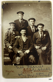 Flagstaff Hill Maritime Museum and Village
Postcard - People, Bill Ferrier - rescuer, 11th November, 1905
... the photograph are the name and place of the photographer, a royal crest.... Printed below the photograph are the name and place ...The postcard shows a photograph of William Ferrier, the 25-year-old Warrnambool fisherman from South Warrnambool whose rescue of two sailors from the wrecked La Bella made him an overnight National hero, quoted as “one of the most heroic rescues in Victoria’s shipwreck history”. The La Bella was wrecked on 10th November 1905 and the photograph was taken on the next day. In the photograph, William Ferrier is seated in the centre, with four of the five survivors beside him: (from left to right) Leonard Robertson, R. Payne, Oscar Rosenholme and Jack Noake. The photograph was taken by Foyle Photography Studio in Warrnambool, originally owned by James Charles Foyle. He previously had a photographic studio in Melbourne 1882 1887, then opened “Foyle’s Photo Card Studios” in Liebig St, Warrnambool. James Foyle died on 13th July 1905 and his son and daughter, Charles and Lilian Foyle continued on with the business until 1945. This photograph was most likely taken by either Charles or Lilian Foyle. The story of William Ferrier’s brave act follows on below … The ship from which the sailors were rescued was the three-masted, iron and steel barquentine the La Bella, built in Norway in 1893. She was one of two iron and steel ships by Johan Smith, the company was one of the leading shipping families in Tvedestrand, Norway. She was significant to Norwegian shipping, being one of only 27 iron and steel ships ever built in Norway. She was registered in New Zealand and engaged from 1902 in inter-colonial trading of timber in the Pacific, between New Zealand and Australia and was often in Port Phillip Bay, Victoria. On 5th October 1905, the twelve-year-old La Bella left Lyttleton, New Zealand carrying a cargo of timber bound for Warrnambool, Australia. She was manned by a crew of twelve: the Master, (Captain Mylius, previously 1st Mate of La Bella, appointed Captain to La Bella on 6th February 1903) 2 Mates, Cook, six able seamen, one ordinary seaman and a boy. Bad weather en route caused her to shelter at Burnie on Tasmania's North West coast. On November 10th, the 37th day of her journey, La Bella approached Warrnambool. Captain Mylius steered her towards Lady Bay Channel in heavy south-west seas and evening mist. He ordered the helmsman to steer for the light. As the ship came round, a tremendous sea struck her on the port quarter, causing her to breach broadside in a northwesterly direction into breakers. The helm was brought round twice more, but each time heavy seas broke over her, the third time throwing the La Bella on to a submerged reef in Lady Bay now known as La Bella Reef (about 100 yards from the Warrnambool breakwater). The sea was so rough that it even wrenched a one-and-a-half ton anchor from its fastenings and into the sea. As Captain Mylius headed to the steel wheelhouse, intending to send up a rocket flare, a huge sea slammed the steel door into him (resulting in massive bruising front and back) Despite his injuries he still managed to set off a blue light, which he held up in his hands. La Bella’s lifeboats were filled with seawater and broke up on their chocks. The blue light was the first indication to people on the shore that there was a ship in distress. The Harbour Master, Captain Roe (who lived in the Harbour Master’s House opposite Flagstaff Hill), organised a group of volunteers to crew the lifeboat because the trained crew was unavailable; the crewmen were working on a steamer in Port Fairy at the time. He then poured oil onto the water to try and smooth the sea. At around 11 pm three of the crew took shelter in the steel forecastle but the sea crashed into it and broke it up. While the rest of the crew and onlookers watched helplessly in the moonlight the bodies were washed away into the sea, never to be seen again. Some of the crew lashed themselves to the weather rail to keep from being washed away. Watson, the ordinary seaman, became tangled in the rigging lines and was too weak to move, so the 2nd Mate, Robertson, put a line onto him so that he wouldn’t wash off. Around 11 pm three of the crew were unconscious from exhaustion. The situation on La Bella was becoming dangerous. The 2nd Mate moved to the ‘house’ and soon afterwards the ship slipped in the heavy sea. The lashings of the 1st Mate and the ‘boy’ Denham had kept them safe until about 2 am when they were washed overboard; no one was able to help. One by one, the exhausted crew were being washed overboard, too weak to hold on any longer. During the night the La Bella had broken into two and the deckhouse ran out towards the sea. Two more men drowned when trying to reach the lifeboat. By sunrise, the only survivors of the twelve were the Master, 2nd Mate and three seamen. Early in the morning, Captain Roe used the rocket apparatus on shore to try and shoot a line to the ship for a safer rescue but each attempt fell short of the target. Several attempts were made by the lifeboat to rescue the stricken sailors, but the rough conditions made this difficult for the boat to get close enough to the ship and the lifeboat had to return to shore. During a final attempt to reach the ship Captain Mylius ordered his men to jump into the sea. Leonard Robertson, 2nd mate, jumped and swam towards the lifeboat, taking hold of the boat hook offered to him. Oscar Rosenholme managed to reach the boat floating on a piece of timber from the ship’s load and a third survivor, Noake, also made the boat. Along with the lifeboat rescue crew, 25-year-old William Ferrier rowed his small dingy through the heavy seas and managed to rescue the Captain, whom he landed on the breakwater. Ferrier then returned to the ship to attempt a final rescue, losing his oars and rowlocks into the high sea. Using just a spare paddle he skulled towards the La Bella, reaching her stern in time to cut loose the lone surviving sailor, Payne, from the lashing that held him to the ship; the terrified sailor dropped from the ship and into the dingy. Shortly after the last man was rescued, the La Bella was lifted by a huge wave and crashed back down on the reef; she broke up and sank. The ordeal had lasted ten hours. The survivors were taken to the nearby Bay View Hotel and gratefully received warm food and clothing, medical attention and a place to sleep. In the following days, an unidentified body of a young person had washed ashore; it was either Watson or Denham. The body was buried in the Warrnambool cemetery with an appropriate gravestone and inscription. William Ferrier became a national hero as news of the daring rescue spread. In recognition of his bravery in the two daring rescues, he was awarded the Silver Medal for Bravery by the Royal Humane Society and was honoured in the letter from the Prime Minister and the Parliament of the Commonwealth, telegrams and a cheque for £20 from the Governor-General, over £150 subscribed by the public, including Warrnambool and district and readers of The Argus, and a gold medal from the Glenelg Dinghy Club of South Australia. Ferrier’s rescue efforts are one of the most heroic in Victoria’s shipwreck history. (William Ferrier’s son, Frank, received a similar award almost fifty years later when he helped rescue four members of the crew on the yacht Merlan after it ran on to a reef near the Point Lonsdale Lighthouse. ) The wreck of La Bella now lies on her port side in 13 metres of sheltered water inside the reef she struck. The bow section is relatively intact and part of the stern has drifted north-easterly towards the mouth of the Hopkins River. The reef the La Bella struck now bears its name. Those five rescued from the La Bella were Captain George Mylius, Leonard Robertson (2nd Mate, 21 years old), R. Payne, Oscar Rosenholme and Jack Noake. Those seven who lost their lives were Mr Coulson (1st mate), Charles Jackman (cook) Gustave Johnson, Pierre Johann and Robert Gent (all able seamen), Harry Watson (ordinary seaman) and Jack Denham (ship’s boy), Captain Mylius was found guilty of careless navigation; he had sailed into the bay without the services of a pilot. His Master Certificate was suspended for twelve months. Later he was also charged with manslaughter of one of the crew who had died when the La Bella was wrecked but found not guilty. The event’s adverse publicity and damage to his career took a toll on his health and he died of a heart attack six months after the wreck; he was only thirty-seven. His body was buried in the Melbourne General Cemetery. The La Bella was “the best documented of all sailing ships owned in New Zealand”. Her record books, ship logs, correspondence and supporting papers are still available. At the time of the tragedy, she was owned by Messers David C.Turnbull and Co. of Timaru, New Zealand timber merchants and shipping agents, who had purchased her on 13th December 1901. A detailed account of the last journey of La Bella can be read in “Leonard Robertson, the Whangaroa & La Bella” written by Jack Churchouse, published in 1982 by Millwood Press Ltd, Wellington, NZ. As well as this postcard, Flagstaff Hill’s La Bella Collection includes a photograph of the wrecked La Bella, a brass rail holder and the letter from the Prime Minister and other Members of Parliament that was sent to William Ferrier to commend him for his bravery. Some 15 – 17 ships are believed to have sunk in Lady Bay, but only two have been discovered on the seafloor; the “La Bella” and the “Edinburgh Castle”. Both wrecks are popular diving sites and are preserved as significant historical marine and marine archaeological sites. This postcard is part of the La Bella Collection and is significant at both a local and state level. Its connection to the La Bella shipwreck and the rescue of five survivors highlights the dangers of Victoria’s Shipwreck Coast. The photograph of William Ferrier and four of the five survivors demonstrates the bravery of ordinary Australians who risked their lives to save victims of shipwrecks along the coast. The postcard is significant to the history of Warrnambool as it portrays William Ferrier, a local fisherman whose descendants continue to live in the area. It highlights the way of life of people who lived in coastal towns in 19th century Victoria and the effects of shipwrecks upon them. The postcard connects to the congratulatory letter which was sent to William Ferrier by the Prime Minister and Government of Australia and demonstrates the importance they attached to his efforts for Victoria and to Australia. The postcard is also an example of the photography of Foyle Photographers who were in the town of Warrnambool from the late 1800’s. Charles and Lillian Foyle took over the business when their father James died in 1905. Lillian Foyle is significant as the first woman photographer in Warrnambool. It is not known whether Charles of Lillian took this photograph. This postcard is significant because of its association with the sailing ship “La Bella”. The “La Bella” is of local and state and national significance. It is one of the only two shipwrecks discovered in Lady Bay, Warrnambool, out of the 15-17 shipwrecks in the bay. Sepia photograph of William (Bill) Ferrier (seated in the middle), heroic rescuer of two crew members of the La Bella, wrecked at Warrnambool. The photograph is a postcard and shows five men dressed formally in suits and hats. Printed below the photograph are the name and place of the photographer, a royal crest and the details of two patrons of the photographer. Also below the photograph are some handwritten words in black pen. On the back of the postcard is a handwritten message in the same writing as the front.Printed on the front of the card is “Foyle, WARRNAMBOOL” “PATRONS: / HIS ROYAL HIGHNESS THE DUKE OF CORNWALL & YORK. / HIS EXCELLENCY LORD BRAS_ EY, R.O.B.” Handwritten on the front of the card is “Bill Ferrier / rescuer / Oh my hero _ _ _ “ Handwritten on the back of the card is a message. “La Bella” Wrecked off W.Bool Breakwater Nov. 1906 (_ _ _ _ show night) Payne Noake Rosenholme Robertson and Capt Mylius (saved) (moonlight bright) Watson (_ _ _ _ boy) Richwoud [possibly Richmond] drowned” and signed “Desdewoua [possibly Desdemona] Slogos”la bella, foyle, william ferrier, bill ferrier, lady bay, 1905, 10th november 1905, 11th november 1905, parliament of the commonwealth, royal humane society medal, flagstaff hill, warrnambool, shipwrecked coast, flagstaff hill maritime museum, maritime museum, shipwreck coast, flagstaff hill maritime village -
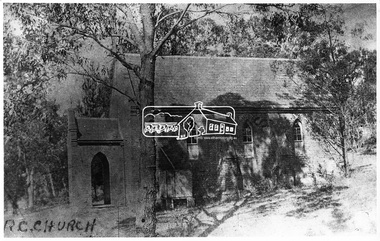 Eltham District Historical Society Inc
Negative - Photograph, Eltham - Old R.C. Church (building not there in 1923)
... architectural (1960s) style church was erected in its place and named... architectural (1960s) style church was erected in its place and named ...Eltham - Old R.C. Church (building not there in 1923). The original St Mary’s Roman Catholic Church (1865-1912) was built of clay brick with buttress walls and a slate roof on the corner of Fordhams Road and Maria Street (Main Road), Eltham South, opposite the present-day Wingrove Park. It was blessed on September 3, 1865. With the arrival of the railway in 1901 and the town centre moving closer to the station, the decision was made to relocate the site of the church to its present-day location on Henry Street at the corner of Main Road. A new timber weatherboard church, also called St Mary's was erected and blessed on October 13, 1912. The church and land cost £1,400 (Evelyn Observer). The original brick church It was demolished in the 1920s and the bricks and windows were recycled to build a dairy on the Brinkkotter farm at Research. The timber church was destroyed by fire in 1961 and a new modern architectural (1960s) style church was erected in its place and named Our Lady of Help Christians Church.This photo forms part of a collection of photographs gathered by the Shire of Eltham for their centenary project book,"Pioneers and Painters: 100 years of the Shire of Eltham" by Alan Marshall (1971). The collection of over 500 images is held in partnership between Eltham District Historical Society and Yarra Plenty Regional Library (Eltham Library) and is now formally known as the 'The Shire of Eltham Pioneers Photograph Collection.' It is significant in being the first community sourced collection representing the places and people of the Shire's first one hundred years.Digital image 4 x 5 inch B&W Negsepp, shire of eltham pioneers photograph collection, eltham, roman catholic church, catholic church, church, main road, st marys catholic church -
 Eltham District Historical Society Inc
Negative - Photograph, St Mary's Roman Catholic Church, Eltham, c.1910
... architectural (1960s) style church was erected in its place and named... architectural (1960s) style church was erected in its place and named ...Note the extensive cracking of the mortar and bricks in the front facade near the portico entrance. The original St Mary’s Roman Catholic Church (1865-1912) was built of clay brick with buttress walls and a slate roof on the corner of Fordhams Road and Maria Street (Main Road), Eltham South, opposite the present-day Wingrove Park. It was blessed on September 3, 1865. With the arrival of the railway in 1901 and the town centre moving closer to the station, the decision was made to relocate the site of the church to its present-day location on Henry Street at the corner of Main Road. A new timber weatherboard church, also called St Mary's was erected and blessed on October 13, 1912. The church and land cost £1,400 (Evelyn Observer). The original brick church It was demolished in the 1920s and the bricks and windows were recycled to build a dairy on the Brinkkotter farm at Research. The timber church was destroyed by fire in 1961 and a new modern architectural (1960s) style church was erected in its place and named Our Lady of Help Christians Church.This photo forms part of a collection of photographs gathered by the Shire of Eltham for their centenary project book,"Pioneers and Painters: 100 years of the Shire of Eltham" by Alan Marshall (1971). The collection of over 500 images is held in partnership between Eltham District Historical Society and Yarra Plenty Regional Library (Eltham Library) and is now formally known as the 'The Shire of Eltham Pioneers Photograph Collection.' It is significant in being the first community sourced collection representing the places and people of the Shire's first one hundred years.Digital image 4 x 5 inch B&W Neg Sepia postcardsepp, shire of eltham pioneers photograph collection, eltham, roman catholic church, church, catholic church, main road, st marys catholic church -
 Tennis Australia
Racquet, Circa 1926
... on reverse. Manufacturer name and place of manufacture printed... reinforcements around shoulders. Racquet model name 'BLUE RIBBON ...A Wright & Ditson 'WLS Blue Ribbon' tennis racquet. String whipping and blue plastic reinforcements around shoulders. Racquet model name 'BLUE RIBBON' , printed along throat on obverse and model name 'WLS' printed as lightning bolts across throat on reverse. Manufacturer name and place of manufacture printed on right side of shaft. Octagonal fine-grooved handle, with leather end wrap. Materials: Wood, Metal, Lacquer, Glue, Ink, Leather, Gut, String, Plastictennis -
 Tennis Australia
Racquet, Circa 1905
... with solid convex throat. Rounded flat top head. Manufacturer name... head. Manufacturer name and place of manufacture printed across ...A Wright & Ditson 'The Park' model tennis racquet with solid convex throat. Rounded flat top head. Manufacturer name and place of manufacture printed across throat on obverse. Model name printed on crown on obverse. manufacturer trademark across throat on reverse. On side of shaft is printed: PATENTED,/JAN. 3, 05,. Fine grooved octagonal handle with leather end wrap. On leather butt cap is inscribed: B/E/200. Materials: Wood, Metal, Lacquer, Glue, Ink, Leather, Guttennis -
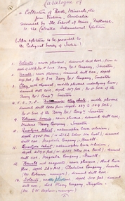 Federation University Historical Collection
Document, SMB: Catalogue of a Collection of Rocks, Minerals, etc, 1883
... relating to the land formations and sections. Places in Victoria... formations and sections. Places in Victoria are named indicating ...This list of rocks, minerals, etc. from Victoria was complied and forwarded by the School of Mines, Ballarat, to the Calcutta International Exhibition. At the end of the exhibition the items were to be presented to the Geological Survey of India. One Hundred items are listed. Pages 4 and 5 also show diagrams relating to the land formations and sections. Places in Victoria are named indicating where items were found. List compiled by Professor Ferdinand Moritz Krause. He joined Ballarat School of Mines in 1880 and lectured in Mineralogy and Geology. He was also the Curator of the Ballarat School of Mines Museum.6 pages, handwrittenSignature of F M Krause Dated 30th August 1883ballarat school of mines, rocks, minerals, calcutta international exhibition, geology survey of india, victoria, professor ferdinand moritz krause, mineralogy, geology, curator, ballarat school of mines museum -
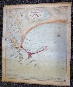 Warrnambool and District Historical Society Inc.
Map - Warrnambool Port 1879, 1879
... with the names of places, geographical and marine features and local... and hand-tinted on canvas with the names of places, geographical ...The port facilities in Warrnambool Bay were in constant use from the first years of Warrnambool’s settlement but there were also difficulties for the shipping trade – a small and unsafe anchorage, the lack of loading facilities and little natural protection from the southerly gales. From the 1870s on there was local agitation for some sort of Breakwater to be built and an Andrew Kerr design was approved by the Warrnambool Council but no funds were made available from the Victorian Government. Throughout the 1870s the building of a Breakwater was a major political issue in the district with preliminary work being funded and started in 1874. In 1879 the Government agreed to a further inspection of the area and an official report. Sir John Coode (1816-1892) was commissioned to make this report. He had come to Australia in 1872 to advise on harbour construction. Coode recommended a 1800 feet long Breakwater and wharf connected to the shore and it was this proposal that the plan described herein and drawn up in 1879 was to accompany. The original plan was eventually modified because of the cost and a Breakwater was completed in 1890 under the direction of the engineer, Arthur Dudley Dobson, with extensions early in the 20th century. This plan is of great interest as it shows in simple graphic form the original plans proposed by Sir John Coode for the Warrnambool Breakwater. It is therefore of great historical importance. The Breakwater was not the maritime success that it was hoped it would be but it is today a significant feature of our foreshore. This is a Plan drawn up in 1879 by Victorian Harbours to accompany Sir John Coode’s Report on the proposed Warrnambool Breakwater. The chart detail is hand-drawn and hand-tinted on canvas with the names of places, geographical and marine features and local points of interest added in print. The edges of the chart are rubbed and the chart is somewhat faded and dirty but the main colours of red, green and brown are still clearly discernible. The title of the plan is printed in an oval inset at the top of the chart. The plan shows two possible Breakwater designs, one from the Borough Surveyor (Andrew Kerr?) and one from Sir John Coode.Victorian Harbours Warrnambool Plan to accompany Sir John Coode’s report Dated 28th Feby 1879 warrnambool breakwater, andrew kerr, sir john coode, arthur dudley dobson, warrnambool, warrnambool harbour, warrnambool history, warrnambool beach -
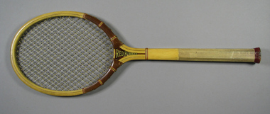 Tennis Australia
Racquet, Circa 1930
... . Manufacturer name and place of manufacture printed on right side... across throat on reverse. Manufacturer name and place ...A Wright & Ditson 'Championship Red Ribbon' tennis racquet. String whipping around shoulders and around base of throat. Racquet model name 'RED RIBBON' , printed along throat on obverse and model name 'CHAMPIONSHIP' printed across throat on reverse. Manufacturer name and place of manufacture printed on right side of shaft. Octagonal fine-grooved handle , with leather end wrap and butt cap. On butt cap is printed 'HIGH QUALITY/JC HIGGINS/TRADEMARK/SPORTING GOODS'. Net strung in diagonal formation. Materials: Wood, Metal, Lacquer, Glue, Ink, Leather, Nylon, Stringtennis -
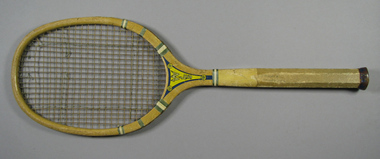 Tennis Australia
Racquet, Circa 1926
... whipping around shoulders and base of throat. Racquet model name.... Manufacturer name and place of manufacture printed on right side ...A Wright & Ditson 'WLS Blue Streak' tennis racquet. String whipping around shoulders and base of throat. Racquet model name 'BLUE STREAK', printed along throat on obverse and model name 'WLS' printed as lightning bolts across throat on reverse. Around the 'WLS' emblem there are three circular designs with 'SR/Co' (retailer name) contained within each. Manufacturer name and place of manufacture printed on right side of shaft. Octagonal fine-grooved handle, with leather end wrap. Materials: Wood, Metal, Lacquer, Glue, Ink, Leather, Gut, Stringtennis -
 Federation University Historical Collection
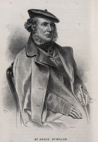
Drawing - Image - black and white, Angus McMillan, c1835
... on in folklore, mainly in place names pinpointing what some historians..., but lived on in folklore, mainly in place names pinpointing what ...Angus McMillan named the Avon River after the river of the same name in his native Scotland. In 1840 he established a pastoral run at Bushy Park, north-west of the township. William Odell Raymond established a run in the area in 1842, and built his house, Strathfieldsaye, during 1848–54. European settlement did not take place without resistance, and in return, massacres were inflicted by Angus McMillan and others on Gunai people, especially between the years of 1840 and 1850. (wikipedia) The first application for the 'Bushy Park' run appears in the “Port Phillip Gazette” on 13 August 1843. It was taken up by Angus McMillan, who also took up the 'Boisdale' run for his employer Lachlan Macalister at the same time. In March 1844 a Licence to occupy the 16,000 acre 'Bushy Park' was granted to McMillan. In the late 1840s Andrew Martin and Matt McCraw built Angus McMillan's Bushy Park homestead. Aboriginal killings in Gippsland area most often were never formally recorded, but lived on in folklore, mainly in place names pinpointing what some historians now refer to as "massacres", and others as "conflicts". There is Boney Point, on Lake Wellington, Butchers Creek, near Metung, Slaughterhouse Gully, at Buchan, Skull Creek, at Lindenow, and, notoriously, Warrigal Creek, at Woodside. "Here, according to a couple of contemporary - though not eyewitness - reports, between 50 and 150 blacks were killed in an orgy of revenge after the murder and mutilation of a leading Scots settler, Ronald Macalister. If anybody had any doubts about the fitness of commemorating McMillan's name, no one voiced them then. Gippsland was, and still is, dotted with stone cairns tracing his route from Omeo, down the Tambo Valley to the fertile plains where he was to make (and lose) his fortune. And where, according to a growing body of opinion, he was to lead the "Highland Brigade", a band of armed settlers, against the Kurnai. History is fiction agreed on, and it is written by the winners. For most of the past 150 years, McMillan has been hailed as a trail-blazing pioneer. The legend began to crumble 20 years ago with publication of new histories, which at first outraged Gippsland historical societies and old residents, but which have gradually changed the way McMillan is viewed. ... Still, not all McMillan's contemporaries agreed with the "Highland Brigade" and its methods. Henry Meyrick, an English-born squatter, wrote to relatives in disgust about his neighbours. He estimated that 450 had been killed, and wrote: "Men, women and children are shot down whenever they can be met with. Some excuse might be found for shooting the men by those who are daily getting their cattle speared, but what they can urge in their excuse who shoot the women and children I cannot conceive." (http://www.theage.com.au/articles/2002/04/26/1019441303552.html, accessed 20 September 2016.) The Gippsland electorate is called 'McMillan' in his honour. Black and white image of a man wearing a coat and beret. He is Scottish born Victorian Squatter Angus McMillan of Bushy Park, Gippsland.angus mcmillan, squatter, aboriginal massacre, bushy park, gunai, avon river, pioneer -
 Bendigo Military Museum
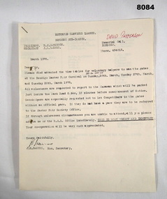
Administrative record - RSL ROSTER EASTER FAIR 1978, Bendigo RSL Sub Branch, March 1978
... is a list of Volunteers names, dates & places ie Art Show... for the Bendigo Sub Branch for many years. The list of names ...The Bendigo Easter Carnival was a Fund Raiser for the Bendigo Sub Branch for many years. The list of names of the volunteers there are many who were tireless workers for the Sub Branch over many years. Name in red pen. David Patterson refer Cat No 8070.Roster, paper, 4 pages stapled together, the 3/4th pages are fold out. Page 1 is a letter from the Secretary Bendigo RSL Sub Branch detailing the dates and places for RSL Volunteers to man the gates at the Easter Fair and events around town. Page 2 is a list of Volunteers names, dates & places ie Art Show at the Memorial Hall, Football at the QEO, Crowning ceremony at White Hills Technical School. Pages 3/4 details names, dates to man the entrance gates to the Easter Fair ie Park Road, Barnard Street, Fernery Gate and Cohns Gate.Page 1, "Returned Services League Bendigo Sub Branch - President D.J. Paterson - Secretary J.K. Barnes - Memorial Hall - Phone 434013 - March 1978. In red pen on page 1. "David Paterson"brsl, smirsl, easter, -
 Bendigo Historical Society Inc.
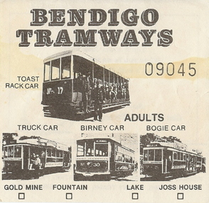
Document - BASIL MILLER COLLECTION: TRAMS - TICKET
... the bottom edge are Four (4) small boxes named for places along... named for places along the tram route, e.g., Gold Mine, Fountain ...Bendigo tramways Talking Tram adult ticket No. 09045.Front: has pictures of Four different types of trams. Along the bottom edge are Four (4) small boxes named for places along the tram route, e.g., Gold Mine, Fountain, Lake, Joss House.al of the above is printed in black. Reverse: Advertisement for the Commonwealth Bank featuring a picture of an elephant and an advertising slogan. Also contains a warning re the dangers and responsibilities of injury or death to persons riding and alighting from these trams. There is a mark from a liquid that has been spilt from side to side, approximately a third down from the top.person, individual, basil miller -
 Bendigo Historical Society Inc.
Newsletter - The Grapevine Cuttings by Rob Upson, 1998 to 2000
... 10828.09 The Origin of Place Names 10828.10 The Tram (Parts 1 to 4... 10828.09 The Origin of Place Names 10828.10 The Tram (Parts 1 to 4 ...Rob Upson became a volunteer at the Bendigo Visitor Centre in 1998. The Staff produced a monthly newsletter called ‘The Grapevine’. Being reasonably new to Bendigo, Rob became interested in its history and began writing articles to share with the volunteers. He called them ‘Grapevine Cuttings’ under the pen name of ‘Merlot’. Rob wrote about 90 articles over a period of 12 years until ‘The Grapevine’ was finally pruned and shutdown. Rob is a valuable volunteer for the Bendigo Historical Society.Sixty Five Newsletters in PDF format from the Grapevine collection that cover the following historical items: Grapevine Newsletters by Rob Upson (Bendigo Historical Society) 10828 Index 10828 Index - Parent Document (This Page) 10828.00 ‘Objection your Honour’ 10828.01 Bendigo’s Gold Volume 10828.02 Harry Boyle (Cricketer) 10828.03 Ellen Clacy on the Goldfields 10828.04 Gold Fever and Vandemonians 10828.05 The Railway to Bendigo (Part 1 and 2) 10828.07 The Pioneer’s Grave at Maiden Gully 10828.08 The First Parliamentary Election, Bendigo 1855 10828.09 The Origin of Place Names 10828.10 The Tram (Parts 1 to 4) 10828.13 W.D.C. Denovan 10828.14 Knipe’s Castle 10828.15 John Hanlon Knipe 10828.16 1st January 1900 in Bendigo 10828.17 William Gay – Bendigo Poet 10828.18 St. Aidan’s Orphanage 10828.19 The Year 2000 – a Prediction from 1967 10828.20 Dr. Henry Backhaus 10828.21 St. Kilian’s Catholic Church 10828.22 S.T. Gill – Goldfields Artist 10828.23 Cobb and Co. 10828.24 ‘The Lights of Cobb and Co.’ by Henry Lawson 10828.25 Federation Celebrations – Sydney 1901 10828.26 The Australian Flag of Stars 10828.27 Old Treasury Building – Melbourne 10828.28 Key Dates in Bendigo’s First 50 Years 10828.29 The March from Robe to Bendigo and China’s Long March 10828.30 A Goldfields Quiz 10828.31 Did You Know That ………..? 10828.32 The Weekly Times 1869 10828.33 Mark Twain in Australia 10828.34 Bendigo’s Jewish Synagogue 10828.35 Sly Grog on the Goldfields 10828.36 A Brief History of Breweries in Australia 10828.37 The Breweries of Bendigo 10828.38 The Cohn Brothers of Bendigo 10828.39 Mary McCarthy – aged 114 10828.40 Langley Hall and Bishopscourt 10828.41 William ‘Bendigo’ Thompson 10828.42 Lachlan MacLachlan 10828.43 ‘Said Hanrahan’ by John O’Brien 10828.44 The Origin of Sandhurst 10828.45 Lister House 10828.46 Arthur Thomas Woodward 10828.47 The Students of Arthur Thomas Woodward 10828.48 Henry Leggo 10828.49 Chiko Rolls and Four ‘n Twenty Pies 10828.50 HMVS Nelson and Victoria’s Navy (Parts 1 and 2) 10828.52 Anthony Trollope in Australia (Part 1 to 3) 10828.55 Regional Towns of Victoria – a Quiz 10828.56 Exploration and Settlement of Victoria (Parts 1 and 2) 10828.58 The Major Mitchell Expedition into Victoria (Parts 1 to 3) 10828.61 The Gold Rush (Part 1 and 2) 10828.63 The Road to the Diggings (Part 1 and 2) 10828.65 Harold Desbrowe-Annear (Part 1 and 2) 10828.71 Nom de Plumes 10828.72 The New Zealand Gold Rush 10828.73 Ernst Mueller and Ettore Cadorin 10828.74 Sir John Monash 10828.75 P & O Ships 10828.76 Rosalind Park 10828.82 Bendigo Street Names 10828.83 A Constitutional Proposal and Early Bendigo Vineyards 10828.84 Ferdinand von Mueller 10828.85 John Boyd Watsonhistory, bendigo, grapevine cuttings -
 Dandenong/Cranbourne RSL Sub Branch
Frame of "The Storey Begins", The Australian New Zealand Army Corps .....Lest We Forget
... Deception -A.N.Z.A.C. Names and Places -Battle Honours, Flags, Drums... -A.N.Z.A.C. Names and Places -Battle Honours, Flags, Drums and Medals ...Gold painted wooden framed photograph of 'The Legend of Anzac" with 15 stories are displayed on a cut out on red background. -The Legend Begins -The Land and the Landing -The Chance of a Lifetime-Every Man A Volunteer -The Dardanelles -The Enemy Face- Johnny Turk -Making Do - Home Was Never Like This -An Informal Armistice -A new Landing - The Breakout -Dardanelles Committee -The Home Front -The New Enemy - Winter -Evacuation - The Great Deception -A.N.Z.A.C. Names and Places -Battle Honours, Flags, Drums and Medals -A.N.Z.A,C. … Lest WE Forget. Stating on the top left 2 Australian Medals Gallipoli Star Medal - Victory Medal (next) Rising Sun Badge NZ Expeditionary badge Victory Medal NZ Star Medal Australian Gallipoli Star Medal - The four medal star is bright bronze ensigned with a crown the obverse has cross gladius overlaid with oak wreath that is ensigned with the cypher of Ki ng George V. A scroll bearing the legend 1914-15 is centrally placed across the blades was authorised in 1918 and awarded for service in specified theatres of war between 5th Aug 1914 & 31st Dec 1915. Australian and New Zealand Victory medal is a United Kingdom and British First World War Campaign Medal. The award of a common allied campaign recommended in March 1919. The New Zealand Star Medal, designed R.K. Peacock, eight pointed star (representing NZ and the seven Territories of Australia) surrounding a silver disc with the words " Gallipoli 1914-15. -
 Ballarat Heritage Services
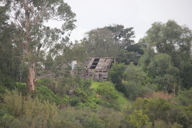
Photograph - Photograph - Colour, Lisa Gervasoni, Remains of Angus McMillan's Bushy Park Home, 2014, 07/06/2014
... on in folklore, mainly in place names pinpointing what some historians... on in folklore, mainly in place names pinpointing what some historians ...Angus McMillan was born in 1810 at Glenbrittle in the Isle of Skye. He was one of fourteens sons of Ewan McMillan. Angus McMillan arried i New South Wales in January 1839, and became an overseer for Captai nLachlan Macalister. I n 1839 Angus McMillan travelled south. He settled for a time on Jame MacFarlane's statin at Currawong. IOn 28 May 1839 Angus MacMillan stated travelling southward toward the coast. Angus Macmillan named the Avon River after the river of the same name in his native Scotland. In 1840 he established a pastoral run at Bushy Park, near Maffra. William Odell Raymond established a run in the area in 1842, and built his house, Strathfieldsaye, during 1848–54. European settlement did not take place without resistance, and in return, massacres were inflicted by Angus McMillan and others on Gunai people, especially between the years of 1840 and 1850. (wikipedia) The first application for the 'Bushy Park' run appears in the “Port Phillip Gazette” on 13 August 1843. It was taken up by Angus McMillan, who also took up the 'Boisdale' run for his employer Lachlan Macalister at the same time. In March 1844 a Licence to occupy the 16,000 acre 'Bushy Park' was granted to McMillan. In the late 1840s Andrew Martin and Matt McCraw built Angus McMillan's Bushy Park homestead. Aboriginal killings in Gippsland area most often were never formally recorded, but lived on in folklore, mainly in place names pinpointing what some historians now refer to as "massacres", and others as "conflicts". There is Boney Point, on Lake Wellington, Butchers Creek, near Metung, Slaughterhouse Gully, at Buchan, Skull Creek, at Lindenow, and, notoriously, Warrigal Creek, at Woodside. "Here, according to a couple of contemporary - though not eyewitness - reports, between 50 and 150 blacks were killed in an orgy of revenge after the murder and mutilation of a leading Scots settler, Ronald Macalister. If anybody had any doubts about the fitness of commemorating McMillan's name, no one voiced them then. Gippsland was, and still is, dotted with stone cairns tracing his route from Omeo, down the Tambo Valley to the fertile plains where he was to make (and lose) his fortune. And where, according to a growing body of opinion, he was to lead the "Highland Brigade", a band of armed settlers, against the Kurnai. History is fiction agreed on, and it is written by the winners. For most of the past 150 years, McMillan has been hailed as a trail-blazing pioneer. The legend began to crumble 20 years ago with publication of new histories, which at first outraged Gippsland historical societies and old residents, but which have gradually changed the way McMillan is viewed. ... Still, not all McMillan's contemporaries agreed with the "Highland Brigade" and its methods. Henry Meyrick, an English-born squatter, wrote to relatives in disgust about his neighbours. He estimated that 450 had been killed, and wrote: "Men, women and children are shot down whenever they can be met with. Some excuse might be found for shooting the men by those who are daily getting their cattle speared, but what they can urge in their excuse who shoot the women and children I cannot conceive." (http://www.theage.com.au/articles/2002/04/26/1019441303552.html, accessed 20 September 2016.) The Gippsland electorate is called 'McMillan' in his honour. Photographs of the remains of a timber home used by squatter Angus McMillan at his "Bushy Park" property on the Avon River. angus mcmillan, bushy park, avon river, squater -
 Warrnambool and District Historical Society Inc.
Notes, Lecture Notes - type written
... on the origin of street names in Warrnambool. Wicking Place... of street names in Warrnambool. Wicking Place in Warrnambool ...These typed notes have been prepared by Tom Wicking to be used in conjunction with his collection of slides on local history. Tom Wicking was a noted local historian, particularly well-known in the 1970s and 80s. He was an early active member of the Warrnambool and District Historical Society and was involved in the establishment of Flagstaff Hill Maritime Museum in the mid 1970s. He also produced a revised edition of the booklet containing notes on the origin of street names in Warrnambool. Wicking Place in Warrnambool is named after him.He died in the late 1990s. These notes and slides were part of Wicking’s deceased estate and have been de-acquisitioned from the Flagstaff Hill collection and passed to the Warrrnambool and District Historical Society through the estate of Les O’Callaghan.These notes were for use in slide shows etc and have a limited use today as the historical information contained therein is continually being revised and technology has changed The slide material has been scanned and will be better utilized this way in a power point presentation etc. Typed sheets on aspects of Warrnambool and district history – note-book size (13 packs); quarto size (1 pack). warrnambool, tom wicking -
 Ballarat Tramway Museum
Postcard, Bascands Ltd. Christchurch NZ, SECV Ballarat trams 27 and 38, 1980-1981
... ) and photographers name, with place for stamp and address. Four copies held... and number (M508) and photographers name, with place for stamp ...Colour postcard of SECV Ballarat trams 27 and 38 crossing at Gardens Loop in Wendouree Parade during the early 1980's by John Phillips for a BTPS postcard. Tram 27 has a "Brambles" advertisement and a "TWIN LAKES" sign. Both trams showing St Aidans Drive destination and "TRAM RIDES" signs. Trams in SECV livery. See also Reg. item 2787 for a similar photograph taken at the same time. On rear is a note regarding the trams, the tramway operations, printers name, logo and number (M508) and photographers name, with place for stamp and address. Four copies held. BTPS Annual Report 1980-1981. Used in postcard display 2017-2018 See image i1 for a copy of the original photo - refer to Reg Item 8193 for an associated email.trams, tramways, wendouree parade, btps, postcards, gardens loop, tram 913, tram 345