Showing 2244 items
matching railway line
-
 Rutherglen Historical Society
Image
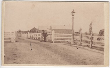
... Small photograph of the High Street Bridge over the Railway... Street Bridge over Railway Line"... Pearce. B Jasper" "High Street Bridge over Railway Line" Small ...Small photograph of the High Street Bridge over the Railway line.On back: "With complements of NG Pearce. B Jasper" "High Street Bridge over Railway Line"high street, railway -
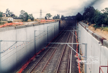
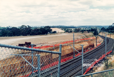
 Ringwood and District Historical Society
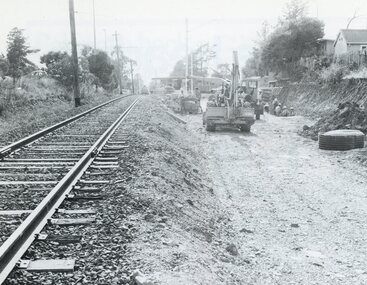
Photograph, Duplication of the five-kilometre section of railway line between Ringwood and Croydon in 1983
... Duplication of the five-kilometre section of railway line... of railway line between Ringwood and Croydon in 1983 Photograph ...Digital scanFrom Vicrail News magazine, April 1983. “Duplication of the five-kilometre section of line between Ringwood and Croydon is on the way. Several major works will be undertaken over the next few months so the two tracks can be brought into service later this year. Intensive work on this section follows completion of duplication works between Ringwood and Bayswater on the Belgrave line last December. The completion of this 5.17 kilometre section between Ringwood and Bayswater means that this Belgrave line is now duplicated as far out as Ferntree Gully. Commuters using the Belgrave line now have an improved service with the intro duction in January of an additional evening peak train to Upper Ferntree Gully, two additional peak hour services in the morning from both Belgrave and Upper Ferntree Gully, and with the additional tracks delays on one line will not affect trains travelling in the opposite direction. Commenting on the completion of this stretch of track the Minister of Transport, Mr. Crabb, said a further improvement had been made with the commissioning of boom barriers at the Bedford Road level crossing in Ringwood. "The installation is part of the State Government's $9.4 million four-year plan to equip 70 dangerous level crossings throughout the State with boom barriers", he said. Works to be carried out on the Ringwood/ Croydon section include laying of new track, station works at Croydon and installation of boom barriers at East Ringwood. Already completed are bridge works to cater for double tracks at both Mt. Dandenong and Eastfield Roads between Croydon and East Ringwood and construction of an island platform at East Ringwood station. At several locations alignment of the existing track will be slightly relocated. The new line is being constructed with concrete sleepers and heavyweight rails. The existing line will also be reconstructed using these heavy 60kg per metre rails. Engineering works to be completed include installation of overhead wiring necessary to supply power to trains, construction of two new station buildings and a new platform at Croydon, provision of boom barriers, and pedestrian boom barriers at Dublin Road level crossing. East Ringwood, and replacement of existing timber overhead wire support structures with steel structures. Other works in this program included installation of boom barriers at Bedford Road, Ringwood and Scoresby Road, Bayswater and provision of a new platform for trains going to Melbourne and Heathmont. A new timetable on the Lilydale and Belgrave lines will commence when the Ringwood—Croydon duplication track work is completed.” -
 Greensborough Historical Society
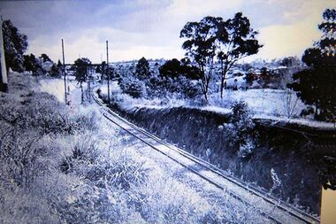
Photograph - Digital Image, Greensborough Railway Line, 1970_
... Greensborough Railway Line.... Greensborough Railway Line Photograph - Digital Image ...Photograph of the rail line approaching Greensborough. This is behind the current RSL, looking towards the Pinehills Estate.Digital copy of black and white photograph. trains, greensborough railway station, pinehills estate -
 Greensborough Historical Society
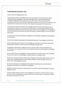
Article and Photograph, Hurstbridge Railway Line, 2016_
... Hurstbridge Railway Line.... Hurstbridge Railway Line Article and Photograph ...Information and photos about the Hurstbridge Rail Line, including a brief history of the line including dates on which upgrades to the line were made.This photograph and text was copied from a Facebook site. Members are people who lived in the Greensborough area and share their reminiscences of the area with others. The site is administered by a GHS member but is not officially affiliated with the Society. Any information is the opinion of the contributor. Article and photograph sourced from social media.hurstbridge rail line, greensborough station -
 Eltham District Historical Society Inc
Photograph, Looking southwest from the location of the new overpass being constructed over the railway line near Watsonia Railway station; Greensborough Bypass construction, c.1986, 1986c
... being constructed over the railway line near Watsonia Railway... overpass being constructed over the railway line near Watsonia ...Colour photograph originally located in a magnetic style album titled 'Greensborough Bypass 1990s 5' suffering significant degradation. No information contained in album or on reverse of photos except where noted. Relocated to archival photosafe storage.greensborough bypass, road construction, greensborough, watsonia railway station -
 Eltham District Historical Society Inc
Photograph, Sherbourne Road bridge construction works over railway line, Montmorency, c.1971, 1971c
... Sherbourne Road bridge construction works over railway line... construction works over railway line, Montmorency, c.1971 Photograph ...Black and white photograph printeltham, sherbourne road, railway bridge, construction, montmorency -
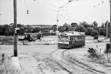
 Ringwood and District Historical Society
Photograph, Railway line construction - Ringwood area. Circa 1880's
... Railway line construction - Ringwood area. Circa 1880's... and white photograph Railway line construction - Ringwood area ...Black and white photograph"Written on back of photograph" Rail line -Ringwood area. 4th from left- Max Miller -
 Stawell Historical Society Inc
Photograph, Glenorchy Saw Mill with the railway line & Mr J E Morris in the foreground 1925-1930
... Glenorchy Saw Mill with the railway line & Mr J E Morris in... Saw Mill with the railway line & Mr J E Morris ...Glenorchy Saw Mill (J.E. Morris 1925-30)stawell -
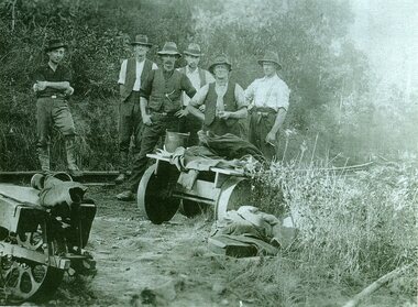
 Nillumbik Historical Society Incorporated
Photograph - Black & white photograph, Fruitgrowers from Diamond Creek District who Lobbied for the Hurstbridge railway line extension
... the Hurstbridge railway line extension ... District who Lobbied for the Hurstbridge railway line extension ... -
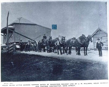 City of Ballarat Libraries
Postcard - Card Box Photographs, House Being Lifted Across Narrow Gates of Buninyong Railway Line By J.M. Williams, House Removal and Cartage Contractor, Dana Street
... House Being Lifted Across Narrow Gates of Buninyong Railway... of Buninyong Railway Line By J.M. Williams, House Removal and Cartage ...Plate 213 Chuck Photo Series.j.m. williams, building, commerical -
 Otway Districts Historical Society
Photograph, Crowes: Terminus of the railway line, 1911
... Crowes: Terminus of the railway line..... Crowes: Terminus of the railway line. Photograph ...The terminus of the railway, and the southern-most station on the Australian mainland, was Crowes, approximately 2 kilometres from Lavers Hill. The line ended at "The Black Stump". Crowes was designed as a fully functioning terminus and received a complete instalment of facilities. The site was laid out with three roads plus a dead end siding for a locomotive shed and ash pit. Goods sheds, a platform and livestock ramps catered for freight loadings, while on the north side was a station office, waiting room, parcels shed and passenger shelter. Three departmental residences were also provided. The resident Station Master was withdrawn in November 1916 and the station closed with the line on 10 December 1954.Photograph. Terminus of the Colac-Crowes at Crowes.crowes; terminus; "the black stump"; -
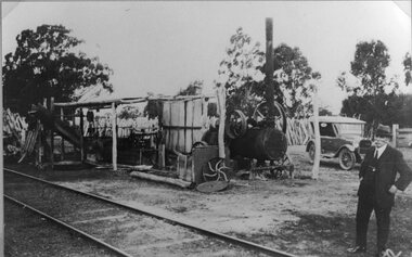
 Stawell Historical Society Inc
Photograph, Railway Line Construction in Stawell area
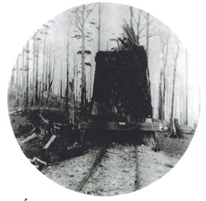
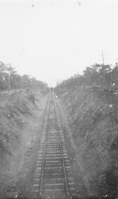
... Railway Line Construction in Stawell area ... the depression. Stawell Railways Transport Railway Line Construction ...Group of three photos from of men constructing railway cutting Wildcat Hill beside Napier Street. Norn Gray born Stawell 1911 and his father Robert worked on the cutting during the depression.stawell railways transport -
 Victorian Railway History Library
Book, Australian Railway Historical Society (S.A. Division) Inc, The Victor Harbor Railway Line Pictorial Review, 1984
... The Victor Harbor Railway Line Pictorial Review... Australian Railways line to a tourist railway. ill, maps, p.52 ...A pictorial review of the railway to Victor Harbor in South Australia from an South Australian Railways line to a tourist railway.ill, maps, p.52.non-fictionA pictorial review of the railway to Victor Harbor in South Australia from an South Australian Railways line to a tourist railway.railroad construction - south australia - history, preserved locomotives - south australia - history -
 Victorian Railway History Library
Book, New South Wales Department of Railways, Souvenir of the official opening of the Sydney-Melbourne standard gauge railway line, 1962
... standard gauge railway line.... line. Book New South Wales Department of Railways ...Souvenir booklet on aspects of the opening of the Sydney to Melbourne standard gauge line in 1962Ill, p.58.non-fictionSouvenir booklet on aspects of the opening of the Sydney to Melbourne standard gauge line in 1962railways - australia - history, railway gauge - australia -
 Victorian Railway History Library
Book, James, Ken et al, A History of the Redesdale Railway Line 1891-1954, 2014
... A History of the Redesdale Railway Line 1891-1954... of the Victorian Railway's branch line from Kyneton to Redesdale ...A comprehensive history of the Victorian Railway's branch line from Kyneton to Redesdale in Victoria from 1891 to 1954.index, ill, maps, p.238.non-fictionA comprehensive history of the Victorian Railway's branch line from Kyneton to Redesdale in Victoria from 1891 to 1954.railroad construction - victoria - history, railroads -- victoria -- redesdale -- history -
 Stawell Historical Society Inc
Photograph, Railway Line from the Oddfellows Bridge c1930's
... Railway Line from the Oddfellows Bridge c1930's... Stawell Railways Transport Railway Line from the Oddfellows Bridge ...Sepia Photograph of rail line from Oddfellows Bridge 1930'sstawell railways transport -
 Stawell Historical Society Inc
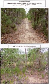
Photograph, A Track into Grampians Quarry -- Previously a Railway Line & Rifle Range Taken 2017 -- 2 Photos -- Coloured
... A Track into Grampians Quarry -- Previously a Railway Line... into Grampians Quarry -- Previously a Railway Line & Rifle Range Taken ...Two colour photographs of Track into Quarry Road Grampians. Once Rail Line used in construction of dam wall, later used as rifle range. The rifle range was once the last part of the railway track that ran to the quarry which was used to cart stone to Lake Fyans when it was being constructed. (1912-1918). The rifle butts are near to or part of the quarry. The Rifle range can still be seen. Two colour photographs of bush setting with track and dirt mound (rifle butts)stawell -
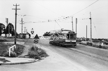
 Ringwood and District Historical Society
Photograph, Drainage works under railway line between Ringwood and Heathmont C 1950's
... Drainage works under railway line between Ringwood and... Drainage works under railway line between Ringwood and Heathmont C ...Black and white photographElectric"Tait" train passing workmen digging drainage works between Ringwood and Heathmont C 1950's -
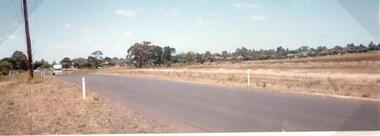
 Hume City Civic Collection
Photograph, c1960s
... Sunbury Railway Line... with the Sunbury Railway line visible across the middle distance.... Vineyard Road Sunbury Asylum Sunbury Railway Line George Evans ...The photograph overlooks former railway land along Vineyard Road which is now a commercial and light industrial estate. It was taken before curbing and footpaths were laid and Vineyard Road was narrow strip of asphalt with the sides of the road unmade.A black and white photograph of Vineyard Road with the Sunbury Railway line visible across the middle distance and the former Sunbury Asylum site in the background.vineyard road, sunbury asylum, sunbury railway line, george evans collection -
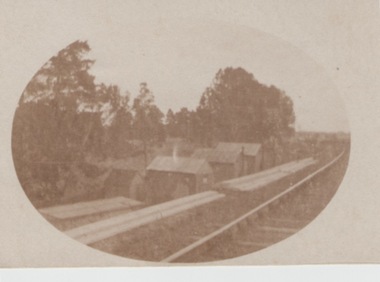 Sunbury Family History and Heritage Society Inc.
Photograph, c1900
... The huts along the railway line were built to house... of a row of small huts along a railway line. With trees forming... along the railway line were built to house 'navvies' who worked ...The huts along the railway line were built to house 'navvies' who worked on and maintained the Bendigo-Echuca railway line. At the time this photo was taken, work was being undertaken on the railway line in the Sunbury area.The Bendigo-Echuca was one of Victoria's earliest government owned and operated regional rail systems. It was an important link with the river traffic along the Murray and Melbourne.An oval shaped sepia photograph within cream border of a row of small huts along a railway line. With trees forming a backdrop. railways, 'navvies' -
 Hume City Civic Collection
Photograph
... the railway line. The railway crossing can be seen in the background... and beside a railway line. It is unmounted.... the railway line. The railway crossing can be seen in the background ...A photo of Old Calder Highway in Diggers Rest with houses on one side and a manmade waterhole on the other side beside the railway line. The railway crossing can be seen in the background next to the railway station.A colour photograph of a waterhole on the side of the road and beside a railway line. It is unmounted.old calder highway, diggers rest, diggers rest railway station, railways, george evans collection -
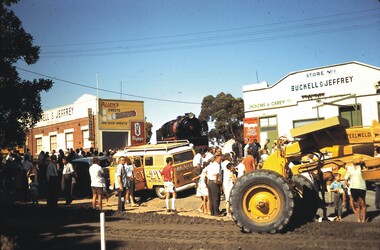 Bendigo Historical Society Inc.
Slide - BENDIGO ASSORTED 1603, 1970
... Train being brought down from railway line Between Buclell...Slide. Train being brought down from railway line Between...SLIDE Bendigo Train being brought down from railway line ...Slide. Train being brought down from railway line Between Buckell and Jeffery Store No.1 and Store No.2, to be postitioned in gardens in Mitchell Street. Dated Feb 1970. BCV-TV van in centre of slide.slide, bendigo, train being brought down from railway line between buclell and jeffery store no.1 and store no.2, to be postitioned in gardens in mitchell street. dated feb 1970. bcv-tv van in centre of slide. -
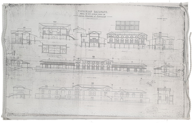 Federation University Historical Collection
Plan, Copy of a Plan of Serviceton Railway Station Building, 1888
... and the Adelaide-Wolseley railway line of South Australia joined...Copy of plan for the Serviceton Railway Line... railway line of South Australia joined. The Railway Station ...The Serviceton Railway Station was completed in 1889 , with the Colony of Victoria and the Colony of South Australia sharing the cost. Ut was at Serviceton the the Victorian rail line and the Adelaide-Wolseley railway line of South Australia joined. The Railway Station included customs offices which were no longer necessary after the Federation of Australian States in 1901. ( https://en.wikipedia.org/wiki/Serviceton,_Victoria, accessed 30 August 2021)Copy of plan for the Serviceton Railway Linerailway, servicetone railway station, plan, serviceton -
 Eltham District Historical Society Inc
Photograph, Bendigo Tramways No. 7 about to arrive at its terminus in North Bendigo near the intersection of Thunder Street and Moray Crescent, January 1972, Jan 1972
... , Moray Crescent, North Bendigo, railway crossing, Railway Line... Crescent where it terminated alongside the railway line in North... Crescent where it terminated alongside the railway line in North ...The tram line proceeds up to the left just pass Moray Crescent where it terminated alongside the railway line in North Bendigo in 1972Digital TIFF file Scan of 35mm Ilford FP3 black and white negative transparencybendigo, bendigo tramways no. 7, george coop collection, moray crescent, north bendigo, railway crossing, railway line,thunder street, tram -
 Eltham District Historical Society Inc
Photograph, Bendigo Tramways No. 7 departs from Thunder Street in North Bendigo en route to Golden Square, Bendigo, January 1972, Jan 1972
... , moray crescent, north bendigo, railway crossing, railway line... Crescent where it terminated alongside the railway line in North... Crescent where it terminated alongside the railway line in North ...The tram line proceeds up to the left just pass Moray Crescent where it terminated alongside the railway line in North Bendigo in 1972Digital TIFF file Scan of 35mm Ilford FP3 black and white negative transparencybendigo, bendigo tramways no. 7, george coop collection, moray crescent, north bendigo, railway crossing, railway line, thunder street, tram -
 Eltham District Historical Society Inc
Photograph, Looking north along Main Road from Cecil Street intersection, Eltham, February 1968, Feb 1968
... railway line... under railway line to the Diamond Creek and Cecil Street sign.... under railway line to the Diamond Creek and Cecil Street sign ...Shows position of under road water course, which also went under railway line to the Diamond Creek and Cecil Street sign.In February 1968 an unknown person took a series of photos from the Eltham Hotel at Pitt Street heading north along Main Road through the shopping centre to just north of Elsa Court covering the length of the section of Main Road which was duplicated shortly thereafter. Shows the condition and environment of the streesscape of Main Road, Eltham immediately prior to the duplication between Pitt Street and Elsa Court through the shopping centre. Also shows a number of shops and businesses that operated at that time.Black and white photographduplication, eltham, main road, cecil street, railway line, watercourse, floods -
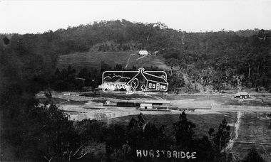 Eltham District Historical Society Inc
Photograph, Hurstbridge - Showing Railway Station
... railway line... of Hurstbridge. The new railway line and station and accompanying works... of Hurstbridge. The new railway line and station and accompanying works ...View overlooking the township and surrounding hills of Hurstbridge. The new railway line and station and accompanying works are central. The extension from Eltham to Hurstbridge opened on 2 January 1912.This photo forms part of a collection of photographs gathered by the Shire of Eltham for their centenary project book, "Pioneers and Painters: 100 years of the Shire of Eltham" by Alan Marshall (1971). The collection of over 500 images is held in partnership between Eltham District Historical Society and Yarra Plenty Regional Library (Eltham Library) and is now formally known as 'The Shire of Eltham Pioneers Photograph Collection.' It is significant in being the first community sourced collection representing the places and people of the Shire's first one hundred years.Digital imagesepp, shire of eltham pioneers photograph collection, diamond creek, hurstbridge, railway station, railroad, railway line -
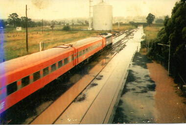 Sunbury Family History and Heritage Society Inc.
Photograph, 17 December 1985
... of the railway line. ... at a station where the railway line has been flooded. A storage silo... silo on the west side of the railway line. sunbury railway ...On 17th December 1985 record torrential rain fell in Sunbury, which flooded the main Melbourne Bendigo rail line and disrupted traffic. The photograph is looking to the north of the station and takes in the historic Macedon Street bridge and the open ground with the storage silo on the west side of the railway line. A coloured photograph of a former V Line train stopped at a station where the railway line has been flooded. A storage silo occupies vac ant ground adjacent to the railway line.sunbury railway station, storage silos, horne street