Showing 1811 items
matching region
-
 Whitehorse Historical Society Inc.
Article, Work Pays Off, 10/11/1992 12:00:00 AM
Springview Primary School winsSpringview Primary School wins Eastern Metropolitan Region Garden Competition.Springview Primary School wins springview primary school, blackburn north, garden competitions -
 Kiewa Valley Historical Society
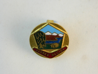
Badge Girl Guides, circa mid to late 1900's
This commemorative badge identifying the wearer as a Girl Guide and was used in the 1970's and later. The Girl Guides "World Camps" was founded in 1924 and each subsequent "camp" was in other global countries. The Camp Baree was held in 1947/1948 in Pennsylvania in the USA. In Victoria, Australia, a Barree Regional location for Girl guides, encompasses the Kiewa Valley and its regions. Girl guides in rural areas covered the same developmental programs as in the city areas but the bush settings of annual camps did not have the same impact as for city based guides. The comradeship however, bringing together girls from a widely diverse background, was still a very important objective of the Girl Guide movementThe significance of this badge is that the Girl Guides held a World Camp in the Barree region which included the Kiewa Valley.This world wide attention(Girl Guides) to this region paid special attention to the "home side" girls and highlighted in particular those girls in the Kiewa Valley who participated in the Girl Guide movement. The ability to have such a personal contact with so many girls from so many world regions helped to break the somewhat isolated regional life. The fundamental lessons of the girl guides was and still is to enrich young girls knowledge of skills which provides self esteem, pride in achievements and the togetherness with like minded girls. Social barriers are left behind and good friendships are formed. Some of these friendships continued as life long links.This round badge made from brass and has coloured enamel sections outlining various "Barree Region" scenery. In the far distant horizon are snow capped mountains. These are coloured brown with white tipped summits.The central focus is a blue stream with a dark blue "gum" tree to the left and a brass etched tent pegged onto green grass. These pictures are framed within a house structure. A red coloured boomerang lies under the "house" frame with the name of the region on it,"BARREE REGION" The badge is fastened onto a lapel or other clothing by two "L" shaped hooks extending from the back of the badge.On the front of the badge (on the sketched boomerang "BARREE REGION". On the back in raised lettering is"BERTRAM BROS MELB."societies, girl guides, barree region, metal identity badges -
 Wannon Water
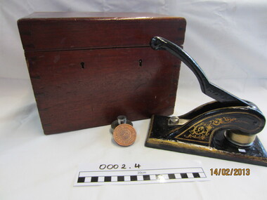
Antique cast iron seal embossing press, Roeszler, Seal
Hamilton Waterworks Trust was a predessor authority to Glenelg Region Water Authority (Glenelg Water). Glenelg Region Water Authority was constituted on 1 July 1994 under the Water Act 1989 and amalgamated the previous authorities of Glenelg Wannon Water Board, Glenelg Waterworks Trust, Hamilton Water Board and Shire of Mount Rouse Water and Sewerage Authorities.A cast iron seal press. This was used by Hamilton Waterworks Trust and its successor Glenelg Region Water Authority to emboss agreements and official documents. Die is still attached to the press. It reads: Glenelg Region Water Authority 1994. Hamilton Waterworks Trust die reads 1899.Cast iron press with handle and 2 inscripted brass diesHamilton Waterworks Trust Glenelg Region Water Authorityhamilton, glenelg region, public administration, water supply, amalgamation -
Marysville & District Historical Society
Article (item) - Newspaper article, The Alexandra and Eildon Standard, Indigenous history in the shire after colonisation, 08-03-2017
A newspaper article regarding indigenous history in the Murrindindi Shire after colonisation of the region.A newspaper article regarding indigenous history in the Murrindindi Shire after colonisation of the region.Wednesday, March 8, 2017alexandra, kulin, taungurung, goulburn, woi wurrung, yarra, acheron river, little river, dandenong ranges, land board, aboriginal guardian, william thomas, aboriginal station, lands minister, acheron station, mohican run, rubicon river, cathedral mountain, john green, mohican station, upper yarra, yarra tribe, woori yallock, hoddles creek, yarra river, badger creek, healesville, coranderrk, christmas bush, prostanthera lasianthos, black's spur -
 Bendigo Historical Society Inc.
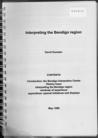
Booklet - David Dunstan - Interpreting the Bendigo Region
Compilation of natural, historic and commercial attractions of the whole Bendigo RegionDavid Dunstan - Interpreting the Bendigo Region. The Bendigo Interpretive Centre will combine Technoloy and traditional display techniques with user-friendly on-line tourist information to provide easy access to information on the rich array of natural, historic and commercial attractions of the whole Bendigo Region.natural, historic and commercial attractions of the whole bendigo region -
 Marysville & District Historical Society
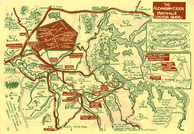
Map (Item) - Tourist map, The Alexandra and Eildon Standard, THE ALEXANDRA & EILDON MARYSVILLE VISITOR GUIDE, 1997
A tourist map for the Alexandra, Eildon and Marysville region that was produced by the Alexandra and Eildon Standard newspaper. This tourist map was produced in 1997.A tourist map for the Alexandra, Eildon and Marysville region that was produced by the Alexandra and Eildon Standard newspaper.c 1997/ PUBLISHED BY/ THE ALEXANDRA/ AND EILDON/ STANDARD./ GRAPHICS/ BY THE T.T.S./ EILDON.alexandra, eildon, marysville, victoria, australia, tourist map, alexandra & eildon standard -
 Marysville & District Historical Society
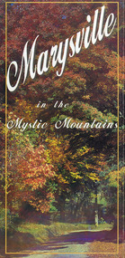
Map (Item) - Information brochure, Project Art & Photo, Marysville in the Mystic Mountains, Unknown
An information brochure on Marysville, the surrounding district and the natural attractions in the region published by Mystic Mountains Tourism.An information brochure on Marysville, the surrounding district and the natural attractions in the region published by Mystic Mountains Tourism.marysville, victoria, australia, information brochure, mystic mountains, mystic mountains tourism, cathedral range, lady talbot drive, cameron cascades, phantom falls, keppel falls, beech forest cascades, the beeches rainforest walk, the big tree, cumberland memorial scenic reserve, cambarville, cumberland falls, cora lynn falls, the big culvert, steavenson falls, lake mountain, marysville visitor information centre -
 Marysville & District Historical Society
Map (Item) - Information brochure, Project Art & Photo, Marysville in the Mystic Mountains, Unknown
An information brochure on Marysville, the surrounding district and the natural attractions in the region published by Mystic Mountains Tourism.An information brochure on Marysville, the surrounding district and the natural attractions in the region published by Mystic Mountains Tourism.marysville, victoria, australia, information brochure, mystic mountains, mystic mountains tourism, cathedral range, lady talbot drive, cameron cascades, phantom falls, keppel falls, beech forest cascades, the beeches rainforest walk, the big tree, cumberland memorial scenic reserve, cambarville, cumberland falls, cora lynn falls, the big culvert, steavenson falls, lake mountain, marysville visitor information centre -
Whitehorse Historical Society Inc.
Article, Guiding the way, 2006
Blackburn South Guides celebrate their 40th Anniversary (photo of District Leader, Susan Errey).Blackburn South Guides celebrate their 40th Anniversary (photo of District Leader, Susan Errey). Book comp. by Anne Taylor, Maroondah Region SecretaryBlackburn South Guides celebrate their 40th Anniversary (photo of District Leader, Susan Errey).errey, susan, girl guides, blackburn south -
Whitehorse Historical Society Inc.
Pamphlet, Neighbourhood activity in Nunawading, 1977
An attempt by the E.R.E.C. / ACCESS Community Education Project to increase the awareness of community activity and involvement in the municipality.An attempt by the E.R.E.C. / ACCESS Community Education Project to increase the awareness of community activity and involvement in the municipality. Includes maps of region showing community centres etc.An attempt by the E.R.E.C. / ACCESS Community Education Project to increase the awareness of community activity and involvement in the municipality. city of nunawading, east burwood recreation association, north blackburn community action group, vermont south community association, libraries, social services, emergency services -
 Kiewa Valley Historical Society
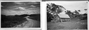
18 small black and white photographs of the Bogong High Plains, 1948
These photos of the Bogong High Plains were all taken by Ronald George Thorn who was a cadet engineer with the State Electricity Commission. He worked on the Kiewa scheme from 1948 to 1950 doing overhead line construction and maintenance plus electrical design and drawing work. They are from his personal collection and a record of his time in the Kiewa area.Pictorial history of personal involvement in the the early days of the Kiewa Scheme.18 small black and white photographs all taken on the Bogong High Plains.Photo 1 Wallace's Hut. Photo 2 Ruined Castle - Looking towards Pretty Valley December 1948. Photo 3 Ruined Castle - Looking towards Pretty Valley December 1948. Photo 4 Ruined Castle - Looking Down Valley December 1948. Photo 5 - Mt. McKay from Ruined Castle October 1948. Photo 6 View from Rocky Valley Camp October 1948. Photo 7 Mt. Feather Top from Ruined Castle October 1948. Photo 8 View from Ruined Castle looking downwards towards Beauty October 1948. Photo 9 Rocky River from gauging station October 1948. Photo 10 Rocky Valley River from main road October 1948. Photo 11 View along little Arthur Fire Track October 1948. Photo 12 View along main road. Looking towards Beauty Valley October 1948. Photo 13 View from Little Arthur Fire Track October 1948. Photo 14 Frying Pan Spur from Rocky Valley Road October 1948. Photo 15 Mt. Bogong from Big Hill Fire Track October 1948. Photo 16 View from Big Hill Fire Track October 1948. Photo 17 Mt. Feathertop from Ruined Castle October 1948. Photo 18 Mt. Fainter from Ruined Castle October 1948. (All of the above is hand written on the back of photos in ink). bogong high plains; r g thorn; secv; kiewa hydro electric scheme; pictorial history -
 Burrinja Cultural Centre
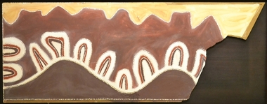
Aboriginal painting - Paddy Jampin Jaminji, Paddy Jaminji, The Hills of Bedford Station, pre 1995
In around 1924 a band of Gija people crossed fences onto their traditional land near Bedford Downs Station in the East Kimberley 2000 km northeast of Perth and killed nine head of cattle. This act precipitated one of the massacres to become known as the 'killing times'. Paddy Quilty, the station owner of Bedford Downs had his men collect wagon loads of firewood which was distributed around the camp. He then invited everyone to assemble for their rations. The food, laced with strychnine, was handed out. As the Gija people fell down dying in agony, they were shot. The firewood was used to burn the bodies. One boy escaped to the the story. Paddy Jamin Jaminji (c.1922-1997) painted The Hills of Bedford Downs Station as part of a series of painting about the Killing Times. It depicts the story and sites of the massacre. At least twelve killing sites are recorded within a radius of 150 km of Turkey Creek, WA. The painting was possibly discarded due to its damage in one corner and later collected from an old shelter at Warmun on a field trip by collector Neil McLeod in 1995.Large painting on board of symbolic landscape. Brown, yellow, cream and white. Framed.bedford downs station, massacre, killing, gija, paddy quilty, turkey creek, warmun -
 Buninyong Film Festival
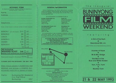
BFF Brochure, Buninyong Film Festival Brochure 1993, 1993
2 x A4 Green PaperBFF Logo, film screenings, misc details -
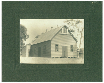 Tarnagulla History Archive
Photograph of a wooden school or church house at or near Tarnagulla, A wooden school or church house at or near Tarnagulla, c. 1900
Murray Comrie Collection. A black and white photograph depicting a wooden shool or church house at or near Tarnagulla. Mounted onto heavy dark brown card.Nonetarnagulla, buildings, schools, churches -
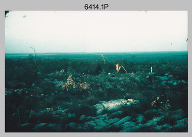
 Bendigo Military Museum
Photograph - 4th Field Survey Squadron deployed on Operation NERIGHT, Queensland & Northern Territory, 1989
This is a set of 19 photographs taken in 1989 during 4th Field Survey Squadron’s deployment on Operation NERIGHT 89 in Queensland and the Northern Territory. It was a two-part operation in 1989 with work conducted in the areas of Camooweal and Weipa. Part 1 was the field completion of topographic maps conducted near Camooweal QLD, along the Barkley Highway on the border between NT and QLD, from the 12th of September to the 20th of October 1989. A Bell Kiowa LOH helicopter from 162 Recce Sqn supported topographic field completion. Operation NERIGHT 89 Part 2 was the acquisition of mapping control by GPS field parties utilising Texas Instruments TI4100 Global Positioning System receivers around Weipa on Cape York Peninsula from the 22nd of September to the 22nd of October 1989. Part 2 Two Bell UH-1H Iroquois helicopters from RAAF’s 35 Squadron were principally used to deploy GPS field parties. Identification photography of control points was taken by air camera operators in AAAvn Pilatus Porter aircraft from 173 Gen Spt Sqn fitted with an RC10 aerial camera. The two parts of the operation were conducted concurrently. This is a set of 19 photographs taken in 1989 during 4th Field Survey Squadron’s deployment on Operation Neright in Queensland & the Northern Territory. The colour photographs are on 35mm negative film and are part of the Army Survey Regiment’s Collection. The photographs were scanned at 96 dpi. .1) to .3) - Photo, colour, 1989. En-route to areas of survey operations. .4) to .5) - Photo, colour, 1989. Unidentified personnel relax next to river/waterhole. .6) - Photo, colour, 1989. Two Bell UH-1H Iroquois helicopters from RAAF’s 35 SQN utilised in the movement of GPS parties. .7) to .9) - Photo, colour, 1989. Unidentified soldier practices repelling from a UH1H Iroquois helicopter. .10) - Photo, colour, 1989. Inside the cockpit of a UH1H Iroquois helicopter. .11) - Photo, colour, 1989. Field Party camp with GPS equipment in foreground. Unidentified soldier prepares a meal. .12) - Photo, colour, 1989. GPS antenna plumbed over a survey ground mark. Witness post on left. .13) & .14) - Photo, colour, 1989. Unknown Cape York Peninsula beaches. .15) & .16) - Photo, colour, 1989. Dramatic fire next to base camp. .17) - Photo, colour, 1989. Aboriginal rock art at unknown location. .18) - Photo, colour, 1989. Aboriginal rock art at unknown location. L to R: unidentified, SPR Andrew Quin. .19) - Photo, colour, 1989. Aboriginal rock art at unknown location. LT Chris Topovsek..1P to .19P – There are no personnel identified. ‘1989 OP NERIGHT’ annotated on negative sleeve.royal australian survey corps, rasvy, 4 fd svy sqn, op neright 89 -
 Bendigo Military Museum
Photograph - Royal Australian Survey Corps Surveyors in the Field – Northern Territory and Queensland, 1959 – 1960
This is a set of 10 photographs of surveyors and support staff in the field undertaking duties in the Northern Territory and North Queensland in 1959 – 1960. The surveyors were employed in the establishment of mapping and geodetic control. In this era surveyors used theodolites to observe horizontal and vertical angles and tellurometers to measure base line distances between survey stations. Laplace survey observations seen in Photo .1P was a series of precise observations carried out at geodetic survey stations to determine astronomic latitudes, longitudes and azimuths to achieve maximum precision in the survey network. Laplace observations were necessary in a geodetic network at every 6th survey station, however the National Mapping Council specified at this time the spacing would be ideally between 4-6 survey stations. The cairn shown in photo .4P was built by RASvy as a landmark over a trigonometric survey station. It was dismantled in 1960 to enable re-occupation and survey observations. It was not restored to the condition shown in the photo.This is a set of 10 photographs of surveyors and support staff in the field undertaking duties in the Northern Territory (NT) and Queensland (QLD) in 1959 – 1960. The photographs were printed on photographic paper and are part of the Army Survey Regiment’s Collection. The photographs were scanned at 300 dpi. .1) - Photo, colour, 1959. Tony Slattery occupying a Laplace survey station on a hill in the Mount Young area of the NT. .2) - Photo, colour, 1959. Surveyors’ camp in the Mount Young area of the NT, L to R: Spencer Snow and Tony Slattery. .3) - Photo, colour, 1959. Surveyors’ camp in the Peckman Hill area, near Katherine in the NT. .4) - Photo, colour, 1959. Cairn on Trig Hill, Borroloola, NT. Built by Spencer Snow, Tom Royle and Jack McCabe. .5) - Photo, colour, 1959. Survey party taking a break next to their Austin Champ vehicle, in transit between Katherine, NT and Wyndam WA. L to R: Tony Slattery, Dave Owens, John Van De Graff. .6) - Photo, colour, 1960. Surveyors’ camp between Mount Isa, QLD and Borroloola, NT. L to R: Pat Cox and John Van De Graff prepare their meal on an open fire. .7) - Photo, colour, 1960. Surveyor - Dennis Woods undertaking survey observations, using MRA1 tellurometer to measure base-line distances NW of Mount Isa, QLD. .8) - Photo, colour, 1960. Unidentified surveyors assessing recovery of their stalled Studebaker truck vehicle after attempting a water crossing in the NT. .9) - Photo, colour, 1960. Unidentified surveyor making batches of bread at a camp in the NT. Seen in the photo placing a lid with hot coals onto the camp oven. .10) - Photo, colour, 1960. Unidentified survey party occupying a survey station on a hill in the Mount near the Lawn Hill area, NW of Mount Isa, QLD. A MRA1 tellurometer to measure base-line distances appear on the right side of the photo. .9) - Photo, colour, 1960. Unidentified surveyors assessing recovery of their stalled Studebaker truck vehicle after attempting a water crossing in the NT. .10) - Photo, colour, 1960. Unidentified surveyor making batches of bread at a camp in the NT. Seen in the photo placing a lid with hot coals onto the camp oven. .1P to .10P annotated on back – personnel names, the year and the location. royal australian survey corps, rasvy, army survey regiment, asr, army svy regt, fortuna, surveying -
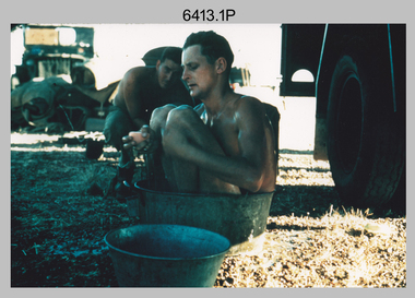 Bendigo Military Museum
Photograph - Royal Australian Survey Corps Surveyors in the Field – North Queensland, 1958
This is a set of seven photographs of surveyors and support staff in the field undertaking duties in North Queensland in 1958. The surveyors were employed in the establishment of mapping and geodetic control. In this era surveyors used theodolites to observe horizontal and vertical angles and chains to measure base line distances between survey stations. Bob Skitch shown in photos .4P to .6P was in the 2nd year of his career in the Australian Army. He achieved the rank of Lieutenant Colonel and his last appointment was the CO of the Army Survey Regiment from 1976 to 1980. The annotation on the back of photo .5P ‘Black foreground is where Bob Skitch boiled billy and started a grass fire’.This is a set of seven photographs of surveyors and support staff in the field undertaking duties in North Queensland in 1958. The photographs were printed on photographic paper and are part of the Army Survey Regiment’s Collection. The photographs were scanned at 300 dpi. .1) - Photo, colour, 1958. Surveyor in Nth QLD enjoying a bath. L to R: Don Cocker, Bob Thompson. .2) - Photo, colour, 1958. Don Cocker surveyor in Nth QLD, enjoying a bath. .3) - Photo, colour, 1958. Surveyors Nth QLD undertaking survey observations, using MRA1 tellurometer to measure base-line distances. L to R: Len Davies, Lou Sommer, John Van De Graff. MRA1 was covered to stop overheating. .4) - Photo, colour, 1958. Surveyors south of Richmond, QLD digging holes for the erection of a Bilby observation tower. L to R: John Van De Graff, Bob Skitch, Kev Moody, Mal Hayes, Don Gray .5) - Photo, colour, 1958. Surveyors south of Richmond, QLD erecting a Bilby observation tower. L to R: Tom Royle, Bob Skitch (on ground level), Mal Hayes. .6) - Photo, colour, 1958. Surveyors south of Richmond, QLD erecting a Bilby observation tower. L to R: Tom Royle, Bob Skitch, Mal Hayes, Jim McGill (on ground level). .7) - Photo, colour, 1958. Surveyors south of Richmond, QLD undertaking survey measurements from a Bilby observation tower..1P to .7P annotated on back – personnel names, the year and the location. Annotated on back of .5P ‘Black foreground is where Bob Skitch boiled billy and started a grass fire’.royal australian survey corps, rasvy, army survey regiment, asr, army svy regt, fortuna, surveying -
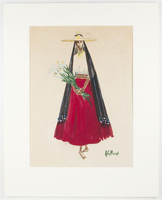 RMIT Design Archives
Painting, Illustration of a Woman in Traditional Dress from Patzcuaro, Michoacán, Mexico, c.1953
Gouache on paper illustration of a woman from Pátzcuaro region, Michoacán, Mexico, by Mexican fashion illustrator Alfredo González Bouret (1926-2018). Likely created in 1953, prior to being exhibited in Mexico and Paris in 1954. From the Patzcuaro region of Michoacán state, Mexico, this woman wears a wide-brimmed 'sombrero' on top of her 'rebozo' - a long rectangular shawl made of wool or cotton with an intricate hand-knotted pattern, popular throughout Mexico. Her hair is held away from her face, likely in long plaits down her back in the traditional style of the region. Her ears and neck are decorated with long earrings and strings of beads, while her plain white blouse is tucked in to a bright red 'refajo' skirt, gathered at the waist by a textile belt with geometric designs. In her hands she holds long-stemmed lilies. While resembling other illustrations of fashion from the Patzcuaro region, this costume stands out for the bright colour of the skirt, and the lack of embroidered decoration on the blouse. Rebecca Lloyd, 2019.Mounted painting of a woman in traditional regional dress from the Patzcuaro region of Michoacán, Mexico. Gouache on paper, c.1953.Signed in green paint, bottom right, 'AG Bouret'.mexico, 1953, fashion design, painting, illustration, mexican, fashion illustration, dress -
Whitehorse Historical Society Inc.
Article, Seeking satisfaction in recreation options
RIGOUR - The Recreation Integration Group.RIGOUR - The Recreation Integration Group. Outer Eastern Region operates as a resource network and referral body to promote and develop leisure options for people with disabilities.RIGOUR - The Recreation Integration Group. disabled, recreation integration group. outer eastern region, kinna, shane -
Lakes Entrance Historical Society
Book, Adams John, The Tambo Shire Centenary History, 1981
A history of the Shire of Tambo, East Gippsland, Victoria, including many aspects of settlement, development, industries, transport, and the hardy people who tamed this varied and often inhospitable region.A history of the Shire of Tambo, East Gippsland, Victoria, including many aspects of settlement, development, industries, transport, and the hardy people who tamed this varied and often inhospitable region.land settlement, transport -
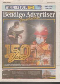 Bendigo Historical Society Inc.
Newspaper - Articles on the 150 years History of Bendigo, Sat July 17 2021
Mayor Jennifer Aiden acknowledged that Greater Bendigo has become a 'thriving', vibrant regional city. The mayor listed the achievements of the city since the discovery of gold change the landscape from that of pastoral. In the other article along with a photo of the fountain, the story relates the history since 1836 when Major Mitchell passed through the central Vicotorian region as one of the first Europeans to walk upon the Dja Dja Wurrung's land.Bendigo Advertiser Two page of articles '150 years in the making'. The article acknowledges the region's past, celebrates the present and looks to the future.'bendigo history -
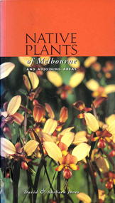 Victorian Aboriginal Corporation for Languages
Book, David Jones et al, Native plants of Melbourne and adjoining areas : a field guide, 1999
A simple guide to the Indigenous plants of the Melbourne region. The extent of the boundaries of this region is outlined in the introduction.Colour photographs, glossarynative plants, melbourne, identification -
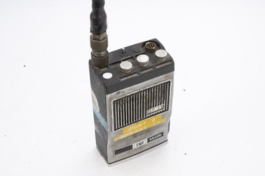 Department of Energy, Environment and Climate Action
ITT Portable radio
After the 1939 bushfires, the Forests Commission Victoria invested heavily in a radically new communications network. After suffering some inevitable delays due to the war, radio VL3AA switched into full operation in October 1945 proudly beaming out 200 watts across the State. But by today’s standards, the technology was primitive and the reception poor unless the user was on a high point somewhere. The radio signal was "line-of-sight" and bounced between fire towers and relay transmitters across the mountains back to the District offices. The advent of solid-state electronics in the 1960s replaced the more delicate valve sets which enabled greater use of vehicle mounted radios. The Commission continued to research, develop and build new radios at its many workshops around Victoria. The network was supported by a large team of skilled radio technicians. The more secure and versatile State Mobile Radio (SMR) digital trunk system came into operation in about 1995. Upgraded Tait Radios were purchased in 2014 after recommendations of the 2009 Bushfires Royal Commission. But it was the convergence of separate technologies such as 5G mobile phones, high-capacity and light-weight lithium batteries, Wi-Fi, the ever-expanding internet, cloud data storage, digital cameras, GPS, personal organisers and hundreds of supporting Apps into powerful smartphones and tablets which revolutionised bushfire communications from the mid-2000s. Portable radio with aerialCFL Orbost Regionbushfire, radios, forests commission victoria (fcv) -
Federation University Historical Collection
Photograph - Colour, Mark Spargo Receiving an Award for Outstanding Trade School Results, 1988, 1988
Mark Spargo had outstanding results from trade school. He completed his modules with 23 credits out od a possible 24. In two of his elective modules he scored 100 percent and his overall acerage mark over three years was 87.5 percent. However, it was not the results alone remarkable as they are - he managed to motivate and maintain the enthusiasm of both his teachers and the rest of the class during the three years. The Western Region Gampians Apprenticeship Scheme runs an annual award for the top apprentice. Mark Spargo Receiving an Award for Outstanding Trade School Results in 1988. He was equal top in the Western Region Apprenticeship Scheme. mark spargo, western region gampians apprenticeship scheme, awards, trades, apprenticeship, apprentice -
Federation University Historical Collection
Book, Wimmera Regional College Steering Committee, Wimmera Community College Study, 1977 and Ballarat TAFE Study, 1977, 09/1977
The Wimmera Region used in the sample included the elctoral division of Wannon, Wimmera and Mallee.Two green soft covered volumes with plastic ring binding. .1) Wimmera Community College Study. Contents include the Wimmera Region, courses, vocational courses, leisure courses. .2) Ballarat TAFE Study. Contents Include aspiratons, community awareness, courses, employment, industry needs, mallee, wimmera, harrow, horsham, dimboola, murtoa, minyip, warracknabeal, stawell, nhill, kaniva, goroke, jeparit, hopetoun, rainbow, edenhope, garoke, rainbow, rupanyup, ballarat tafe, community education, market research, avoca, ballarat, ballan, bet bet, bungaree, buninyong, creswick, daylesford, glenlyon, st arnaud, talbot, clunes, tullaroop -
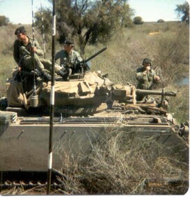 8th/13th Victorian Mounted Rifles Regimental Collection
Photograph - Born digital image
A region on the Lachlan River flood plain north of Booligal New South Wales with its lightly timbered grassland criss-crossed with numerous flowing channels and water filled billabongs provided a challenging training area for a unit equipped with M113 family of vehicles. A Squadron 8/13 VMR deployed there in September 1985 for its annual exercise. The MRV was from 3 Troop commanded by Corporal RAC (Bob) MacDonald of Wangaratta Victoria. Army Reserve training in challenging countryColour image of M113 Medium Reconnaissance Vehicle(MRV) of A Squadron 8/13 Victorian Mounted rifles on annual exercise in Booligal region NSW, 1985.booligal, annual exercise, 8/13 victorian mounted rifles -
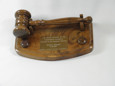 Wannon Water
Gavel, Brian Rowe, 1995
The gavel was presented by Russell Worland (Acting Secretary Glenelg Region Water Authority) to the inaugural chairman of the Glenelg Region Water Authority 1995, Sandra Hempel. Glenelg Region Water Authority amalgamated the previous authorities of Glenelg-Wannon Water Board, Hamilton Water Board, Shire of Dundas and Shire of Mount Rouse Water and Sewerage Authorities and was constituted on 1 July 1994. Glenelg Region Water Authority was then amalgamated with South West Water and Portland Coast Water to form Wannon Water on 1 July 2005.Presented to the first chairman of the newly constituted Glenelg Region Water Authority, a predecessor authority to Wannon WaterWooden turned gavel and a base carved from Konongwootong blackwood, a brass plaque with an inscription. The underneath of the base has an inscription detailing the craftsperson and origin of the wood.Top of the gavel base : "The gavel : symbol of the/ Chairman's authority/ presented to the inaugural Chairman/ Sandra Hempel /17/8/1995/ Glenelg Region Water Authority" Underneath of the gavel base : "Handcrafted by Bryan Rowe/ from Koonongwootong blackwood/ Hamilton August 1995"gavels -
Ambulance Victoria Museum
Ambulance Loading Canvas
Blue canvas, rectangular shape with pockets for carrying poles to be inserted.Mallee Region - Linen Service - Mildura -
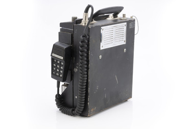 Department of Energy, Environment and Climate Action
Phillips FM 828 Radio
After the 1939 bushfires, the Forests Commission Victoria invested heavily in a radically new communications network. After suffering some inevitable delays due to the war, radio VL3AA switched into full operation in October 1945 proudly beaming out 200 watts across the State. But by today’s standards, the technology was primitive and the reception poor unless the user was on a high point somewhere. The radio signal was "line-of-sight" and bounced between fire towers and relay transmitters across the mountains back to the District offices. The advent of solid-state electronics in the 1960s replaced the more delicate valve sets which enabled greater use of vehicle mounted radios. The Commission continued to research, develop and build new radios at its many workshops around Victoria. The network was supported by a large team of skilled radio technicians. The more secure and versatile State Mobile Radio (SMR) digital trunk system came into operation in about 1995. Upgraded Tait Radios were purchased in 2014 after recommendations of the 2009 Bushfires Royal Commission. But it was the convergence of separate technologies such as 5G mobile phones, high-capacity and light-weight lithium batteries, Wi-Fi, the ever-expanding internet, cloud data storage, digital cameras, GPS, personal organisers and hundreds of supporting Apps into powerful smartphones and tablets which revolutionised bushfire communications from the mid-2000s. Aircraft radio with handsetCentral Gippsland Region 09/067bushfire, radios, forests commission victoria (fcv) -
Whitehorse Historical Society Inc.
Document, Noel Webster papers, 1969-1975
Papers relating to Noel Webster's term as Nunawading Councillor 1969-75, and Mayor 1973-74.Papers relating to Noel Webster's term as Nunawading Councillor 1969-75, and Mayor 1973-74. Contents: 1. Personal certificates, letters of congratulation; 2. Elections 1969-1974; 3. Region 16, Australian Government Regional Programmes; 4. Invitations; 5. Miscellaneous papers and correspondence.Papers relating to Noel Webster's term as Nunawading Councillor 1969-75, and Mayor 1973-74.mayors, councillors, local government, australian government, webster, noel, city of nunawading