Showing 6750 items
matching rivers
-
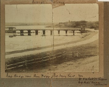 Port Fairy Historical Society Museum and Archives
Photograph, New Bridge over River Moyne Port Fairy East 1902
New Bridge over River Moyne Port Fairy East 1902Black and white photograph view of new bridge over the river Moyne taken in 1902New Bridge over River Moyne Port Fairy East 1902 (handwritten) Mr G.W.Scott C.E.Engineer. .......Watts Riordan Contractorsbridge, river, moyne, river moyne, traffic -
 Orbost & District Historical Society
black and white photographs, Howard D. Bulmer, first half 20th century
This bridge was built in the 1920s as a road and rail bridge, and was partly washed away by flood waters in 1934. After the end of the first World War the Victorian Railways considered an extension of the railhead across the river at Orbost, and in 1922 a new timber and steel girder structure, a joint Country Roads Board — Victorian Railways venture, was built and completed at a cost of £41,000 (the steel girders came from the Flinders Street viaduct reconstruction). Subsequently it was decided not to take the railway across the river, and the bridge has only been used by road traffic. This is a pictorial record of an early bridge across the Snowy River at Orbost.A large black / white photograph of the Orbost Snowy River bridge. There is a large copy as well as a postcard copy in sepia.on front - Snowy River Bridge Orbost H.D. Bulmer - photo - Lake Tyers.snowy-river-bridge-orbost -
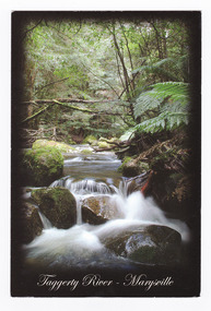 Marysville & District Historical Society
Postcard (item) - Colour postcard, Rosewood Photography, Taggerty River - Marysville, Pre 2009
A colour photograph of the Taggerty River at Marysville in Victoria.A colour photograph of the Taggerty River at Marysville in Victoria. This postcard was produced by Rosewood Photography as a souvenir of Marysville.The Cascading waters of Taggerty River The beautiful & scenic Taggerty River is a 10 minute drive from Marysville, Victoria./ Surrounded by tree ferns & mos covered rocks, the tranquil sounds of the flowing/ river are great place to visit while in Marysville. Photography & Design by/ Roswood Photography/ Mulgrave, Victoria/ [email protected]/ Tel:1300 769 922 Date Stamp 2004/ 6 PM SUNDAY/ Dear Norma & Rod/ All is beauty + peace here/ -the colours are simply/ beautiful every where./ I've done some pleasant/ walking + look forward/ to some more/ Frosty/ mornings perishing - but/ days lovely!!/ Take care - Love-/ Sar-jane A MR + MRS R McDONALD/ 24 PRINCETOWN RD/ MT WAVERLEY/ VIC 3149marysville, taggerty river, victoria, rosewood photography, postcard, souvenir -
 Kew Historical Society Inc
Photograph - Yarra River in flood at the Willsmere Park, 1993
Willsmere Park is bounded by the the Yarra River, Green Acres Golf Club, Willow Grove and the Eastern Freeway. The land on which the park is now situated was bought by Thomas Wills at the Crown Land Sales of 1846 (Section 56). From the 1840s to the 1940s it was intensively farmed. The park is dominated by very large playing fields, while planting to the southern boundary was undertaken when the Eastern Freeway was built. It is only along the banks of the Yarra that there is any remnant native vegetation. Willsmere Park is of significance as an area of open land that remains from the flood plain that once dominated northern Kew. (Source: Kew Conservation Study, 1988)Original colour small format polaroid photograph of the Yarra River in flood at the Willsmere Park, taken on 16 September 1993."Yarra River at Willsmere Park Flooding 16.9.93"willsmere park, yarra river -- floods -- kew (vic.) -
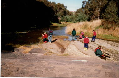 Sunbury Family History and Heritage Society Inc.
Photograph, River studies
... Rivers ...Students from Bulla Primary school were taken to the nearby Deep Creek to study some of the river life inn the local water course.Bulla township is situated in the Deep Creek valley and was an ideal place to take students to study river life close to their school.A coloured photograph of eight children with two adults standing on a rocky outcrop beside a river and looking at the riverlife in the water.rivers, deep creek, river studies, bulla, bulla primary school -
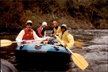 Melbourne Legacy
Photograph - Junior legatee outing, Rafting the Thomson River, 1993
Legacy have many programs to send young junior legatees on activities, camps and outings. The photos shows junior legatees on a white water rafting trip on the Thomson River in 1993. It was stored with other photos of Junior Legatees from the 1980s and 1990s. A record of a Legacy providing experiences for the junior legatees.Colour photo x 5 of junior legatees white water rafting in the Thomson River.Hand written on back in blue ink: 'Junior Legacy Thomson River Rafting. Nov 13/14 1993'junior legatee outing, rafting, river -
 Lakes Entrance Historical Society
Book, Rodwell, Daniel J, Battens Landing, 2005
Research, interpretation and management recommendations for Battens Landing site on the Tambo River, East Gippsland, Victoria.The River Tradewaterways, land settlement, mines and mining -
 Orbost & District Historical Society
folder, Orbost Bridges - Snowy River Road Bridges, 1974 1976
This folder was compiled in October 2015 from documents, magazines. papers and photographs donated by David Jellie, engineer in charge 1974 - 1976. In early 1974, as an Engineer with the Country Roads Board, David came to Orbost as the Supervising Engineer for the construction of the new bridges which were part of an 8.4km Orbost bypass road design. This was a major project involving not only a new bridge over the Snowy River (including Lochiel Lagoon), but other bridges over Ashby’s Gulch and Watt’s Gulch. These new bridges were opened in November 1976 with the unveiling of a plaque on the eastern end of the $2.4M Snowy River Bridge. (ref. May Leatch)This item is a useful reference tool on the construction history of the Snowy River Road bridges.A white plastic folder - Orbost Bridges - Snowy River Road Bridges. it contains newspaper articles, booklets, photographs and documents relating to the construction of the Snowy River Road Bridge in 1974 -1976.on front cover - 1974 - 76 ORBOST / SNOWY RIVER ROAD BRIDGES * construction * photos * articles * plans Donated by David Jellie Oct 2015snowy-river-bridges jellie-david -
 Lakes Entrance Historical Society
Postcard - Brodribb River Bridge, Sherwood, Orbost, 1907 c
Black and white postcard of the bridge over the Brodribb River near Orbost VictoriaBrodribb River 6.4.07waterways, bridges, topography -
 Warrnambool and District Historical Society Inc.
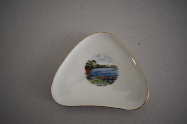
Artefact, Alka, Dish, Mid 20th century
This souvenir dish has been made by the German firm of Alka. The name comes from the surnames of the two proprietors, Alboth and Kaiser. This type of dish was made between 1938 and 1958. Tourism has been an important industry in the Warrnambool area for over 100 years and souvenir dishes of this kind were a popular buy by the visiting tourists. The dish features a scene from the Hopkins River, a fishing and recreational area in Warrnambool since the early days of European settlement. Souvenir dishes such as this one can be sometimes found in local second hand and opportunity shops. This dish is of interest as an example of the high-quality souvenirs bought by local tourists in the Warrnambool area in the mid 20th century.This is a china dish made in a rounded-edged triangular shape. The rim is gilt-edged. In the centre of the dish is a coloured sketch/photograph of the Hopkins River in Warrnambool (Clifton Banks region). ‘Warrnambool Hopkins River’ ‘Alka Bavaria Germany’ tourism in warrnambool, hopkins river, warrnambool, history of warrnambool -
 Lakes Entrance Historical Society
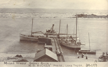
Postcard - SS Blackbird, H D Bulmer Photo Lake Tyers 30.1.07, Marlo Victoria, 1905 c
... Rivers ...Black and white postcard of wharf at Marlo with SS Blackbird moored Marlo VictoriaMarlo Wharf Snowy Riverwaterways, bridges, rivers -
 Australian National Surfing Museum
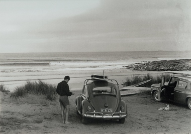
Photograph, Jack Eden, Kennett River, 1964
Black and white photograph taken by Jack Eden at Kennett River, Victoria, in 1964. Image is of a surfer standing next to a VW with surfboards on the roof. Another car and more boards on the ground also appear in the picture. In the background is a peeling wave with a surfer riding it. More surfers sit waiting. Jack Eden was a pioneer of Australian surfing and surf photography. His images capture something of arguably the halcyon days of Australian surfing. Rare image of surfing at remote Kennett Rover along the Great Ocean Road.Black and white photograph taken at Kennett River, Victoria, of a surfer standing next to a VW sedan with surfboards on the roof. Another car and more boards on the ground is to the right of the VW. In the background is a righthand, peeling wave with a surfer riding it.Titled: Australia Jack Eden, Kennett River, Victoriakennett river, surfboards, vw sedan, jack eden, great ocean road -
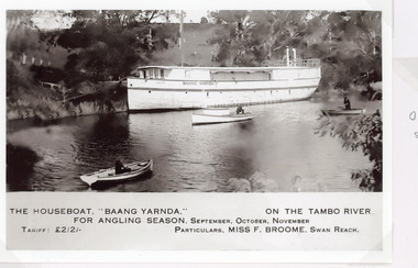 Lakes Entrance Historical Society
Postcard - Baang Yarnda, 1930c
The houseboat Baang Yarnda on the Tambo River for angling season, September October November. Tariff 2 pound 2 shillings Particulars Miss F Broome Swan ReachSepia toned postcard of the houseboat Baang Yarnda associated with Broome's Federal Hotel houseboat is moored in the Tambo River, people fishing from two small rowing boats and motor boat on river. Tambo Upper VictoriaThe Boat Baang Yarnda On the Tambo River. For Angling Season September, October, November Tariff Pounds 2/2/. Particulars:.Miss F Broome Swan Reachguesthouses, tourism, boats and boating -
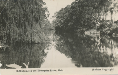 Lakes Entrance Historical Society
Postcard, Bulmer, Thomson River Sale, 1930 c
Message on back from Lois Langley of RAAF SaleBlack and white postcard showing a scene of Thomson River Sale VictoriaReflections on the Thomson River Saleboats and boating, waterways -
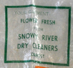 Orbost & District Historical Society
plastic bag, c 1960's
Snowy River Dry Cleaners was situated in Stanley Street, Orbost (previously a hat factory). There was also a shop in the CBD of Orbost. Basil Dowie moved his dry cleaning business from Nicholson Street to 31 Stanley Street where Stuart Hats had been. He had originally bought the business from Laurie Harrington in August 1950. (more information in Orbost & District Historical Society Newsletter No. 138 - John Phillips) This item is from a business no longer existing.A clear plastic bag with green print. - Snowy River Dry Cleaners. attached is orange card - E. Scott 004408Your garment Flower Fresh from Snowy River Dry Cleaners Orbostdry-cleaners-orbost laundry -
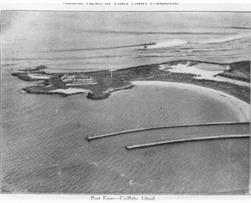 Port Fairy Historical Society Museum and Archives
Photograph, C. 1925
Black and white arial photograph of the Moyne river entrance, the original signed by R.W.Golding.Black and white aerial photograph of Griffith island showing the lighthouse keeper’s compound, the large flagstaff and the river training walls in the foregroundHand written on the back "Port Fairy Moyne River Entrance R. W. Golding Handwritten on the back of the copy "Port Fairyb Harbour 1925"local history, photography, photographs, slides, film, arial, moyne river -
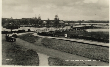 Port Fairy Historical Society Museum and Archives
Postcard, Moyne River, Port Fairy
Postcard made for tourists visiting port FairyBlack and white photograph of the road bridge crossing the river Moyne No 12 - Moyne River, Port Fairymoyne bridge, postcard, botanical gardens, cart, car, river, road, gipps street -
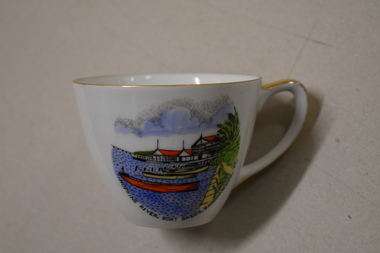 Warrnambool and District Historical Society Inc.
Cuo, Westminster China Australia, Hopkins River Boat, Mid 20th century
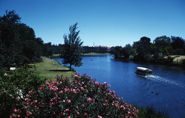
Tourism has been an important industry in Warrnambool for over 100 years. In the late 19th century Warrnambool was promoted as a spa resort offering a mild climate, seaside swimming and hot and cold seawater baths. Today tourists come in winter to see the Southern Right whales at Logans Beach and in summer they come for a beach holiday. The Hopkins River is a popular recreation destination with boating, fishing and water skiing. The Proudfoots Boathouse was established in 1885 by Thomas Proudfoot. This cup is an interesting example of a Warrnambool tourist souvenir from the mid to late 20th century.This is a small white china cup. There is gold edging around the rim and on the handle. On the side of the cup is a coloured image of Proudfoots Boatsheds at the mouth of the Hopkins River in Warrnambool. Hopkins River Boatsheds Warrnambool Fine China Westminster China Australia tourism in warrnambool, history of warrnambool -
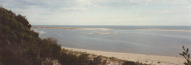 Lakes Entrance Historical Society
Photograph - Mouth of Snowy River, M Fish, Cape Conran Road Marlo Victoria, 2000 c
... Rivers ...Colour photograph of mouth of Snowy River from Cape Conran Road Marlo Victoria. Also a second colour photograph of Snowy River mouth taken from a different anglewaterways, rivers -
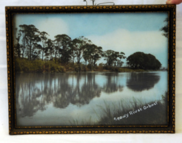 Orbost & District Historical Society
photograph, 1937
The photo was probably taken by Will Herbert and used at the 1937 "Back to Orbost" celebrations. The photo depicts the Snowy River at Orbost when it was at a high level.A coloured photograph in a brown wooden frame which has gold painted decorated edges. A wire hanger is attached. The photo shows reflections of trees along the bank of the Snowy River in 1937.On bottom right of photo - Snowy River Orbost On back of frame - Back to Orbost 1937 from Will Herbertphotography snowy-river orbost-1937 -
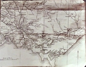 Phillip Island and District Historical Society Inc.
Photograph, Rail Lines of Victoria, Early to mid 20th century
Map showing extensive railway network in Victoria in early C20th.Sepia photo of map of Victoria showing rivers and railway lines and stations.Names of towns, rivers, bays etcsepia photograph, rail transport, victoria, map -
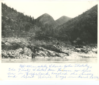 Lakes Entrance Historical Society
Photograph - Snowy River Buchan, 1977 c
... Rivers ...Polish scientist explorer Dr. Lhotsky explored the Australian Alps south of Mt Kosciusko (not named at that date)as far as McKillops Bridge (unnamed then) between 1834 and 1839. His claims were largely ignored he being labelled imposter and humbug but recent research indicates his rightful place amongst Victorias early explorersBlack and white photograph of Snowy River at Suggan Buggan VictoriaApproximately where John Lhotsky the first white man known to have been in Gippsland reached the Snowy and spent three days in March 1834topography, rivers -
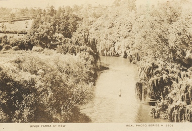 Kew Historical Society Inc
Photograph, River Yarra at Kew, c.1927
The River Yarra was a popular subject for photographic postcards. The postcards provide an interesting perspective of plantings on the banks of the Yarra at various periods. Small, sepia coloured real photo postcard of the River Yarra at Kew. The bird's eye view, presumably taken from Victoria Street Bridge shows the banks of the Yarra in the foreground densely planted with weeping willows. There is also canoe in the foreground. The expanse of lawn in the middle ground is that of 'Swinton', the tower of which can faintly be seen at the top centre of the view. "RIVER YARRA AT KEW / REAL PHOTO SERIES M. 2908 "real photo postcards, yarra river -- kew (vic.), postcards -- 1920s -
 Kew Historical Society Inc
Photograph - Submerged houses in River Avenue, North Kew, 1934
North Kew, now divided between Kew and Kew East, bordered the Yarra River. As such, it was a region subject to flooding in the Yarra Valley. Development beyond this point (ie Kellett Grove) was limited by the City of Kew's planning regulations. Prior to urban development, the area since European settlement and the first land sales in the district in the 1840s, had been used for dairy farming. Vivid photograph contrasting domestic life and relationships with natural disasters such as the flood of 1934.Small sepia snapshot of two submerged houses belonging to local families in River Avenue, North Kew, during the 1934 floods. The view is presumably from near Kellett Grove looking north towards Fairfield.Verso: COES & HYATTS ROOF / RIVER AVENUE / Stamped: 6414yarra river -- north kew, floods -- yarra valley, floods -- north kew, floods -- 1934, natural disasters -- kew -
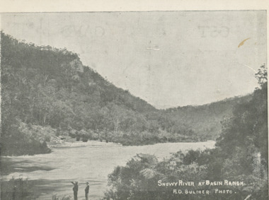 Lakes Entrance Historical Society
Postcard - Snowy River at Basin Ranch, Bulmer, 1930 c
Black and white postcard of Snowy River at Basin Ranch with two men in foreground pointing to high cliff across the river Gippsland VictoriaSnowy River at Basin Ranch H D Bulmer photowaterways, topography -
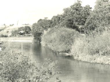 Lakes Entrance Historical Society
Photograph, G Legg Bairnsdale, Tambo River, Tambo Upper Victoria, 1970 1980 c
... Rivers ...Black and white photograph of Tambo River, Tambo Upper Victoria. Also a black and white photograph of flood in the Tambo River location not identified rivers, topography, farming -
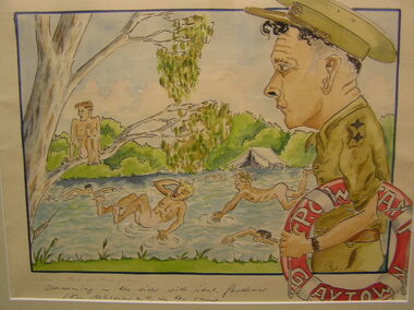 Tatura Irrigation & Wartime Camps Museum
Sketch - Watercolour, Georg Rosenkranz, Swiming in the river with Lieut. Gardener, 1941/2
Artist Georg Rosenkranz, crewman aboard the HSK Kormoran, painted this while at Graytown Prisoner of War Camp.Watercolour painting of people swimming in a river, with onlooking soldierSwimming in the river with Lieut. Gardener for behaviour OK in the Camp.graytown pow camp, georg rosenkranz, illustrations, watercolour, gardener -
 Robin Boyd Foundation
Slide, Robin Boyd
Colour slide in a mount. Torrens River, Adelaide, South Australia, AustraliaMade in Australia / Adelaide (Handwritten) / River (Handwritten)adelaide, slide -
 Lakes Entrance Historical Society
Postcard - Snowy River at Buchan, Rose Series P531, 1970 c
Black and white postcard of the Icicles a stalectite formation in the Buchan Caves 05305.1 Photo by Bulmer Donor Max Davenport 16 March 2019Black and white postcard of the peaceful Snowy River near Buchan VictoriaA Glimpse of the Snowy River near Buchan Vicwaterways -
 Falls Creek Historical Society
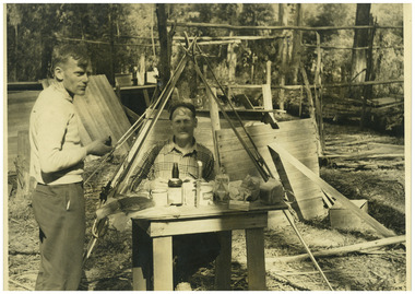
Photograph - Big River Survey Camp, c1949
MEYER COLLECTION - FALLS CREEK PHOTOS In 1947 a determined group of like-minded State Electricity Commission (SEC) staff including Ray Meyer, the chief surveyor of the Kiewa Hydro-Electric Scheme, had a common interest that revolved around the skiing potential of the snow-covered high plains which included what is now the resort of Falls Creek. The six SEC employees, Toni St Elmo, Ray Meyer, Jack Minogue, Lloyd Dunn, Adrian Ruffenacht and Dave Gibson (together with their families) banded together to secretly build a 'hut' that was the first ski lodge at Falls Creek. Using a road built in 1930s to gain access to Falls Creek, their hut project was carried out in secret as efforts by other skiers were blocked by H.H.C. Williams – the engineer in charge of the Hydro Scheme. In 1946 Ray Meyer made a trip to the Lands Office in Melbourne. He came away with a 99-year lease on three acres that was ideally suited for a hut designed by Lloyd Dunn. Adrian Ruffenacht (Design Engineer for the KHS) had suggested where the group should build because of easy access to a spring for water. Much of the building material required was scavenged from derelict huts on the high plains. Due to the need for secrecy, the determined group worked on the hut in the evenings and weekends to avoid detection. During the building period the group had met at Echidna Rock (now known as Eagle Rock) where Skippy St Elmo announced, "This is my favourite ‘Skyline’.” And so the first lodge in the area at Falls Creek Ski Resort came into existence. With the development of the International Poma in the 1970s, the Skyline Lodge, which was sited between the ski-lift’s pole one and pole two, was demolished. However, the legacy of Ray Meyer, Toni St Elmo, Jack Minogue, Lloyd Dunn, Adrian Ruffenacht and Dave Gibson and Skyline lives on in the vibrant atmosphere of Falls Creek Resort. The MEYER COLLECTION documents developments on the Kiewa Hydro Scheme and their life at Falls Creek from the mid 1930s to 1960s.This image is significant because it documents development of the Kiewa Hydroelectric Scheme.Two black and white images at the Big River Old Survey Camp.Photo 1 - Breakfast at Big River Left to RIght Ray Meyer, Wal Johnson Photo 2 - Big River Survey Camp at foot of T Spur C 1949, Kiewa RIver Survey Team.kiewa hydroelectric scheme, ray meyer, wal johnson