Showing 1854 items matching " subdivision"
-
 Greensborough Historical Society
Poster - Planning Document, City of Heidelberg, Subdivision Plan # G 27, Greensborough and Diamond Creek, 1922 and 1963
Plan of Subdivisions in City of Heidelberg: Side 1: 2 plans, Parish of Keelbundoora: plan 1: Henry Street, Vermont Avenue, Lyell Street, Nell Street, McDowell Street, 1922. Plan 2: Henry Street, Nepean Street, Charles Street, 1922. Side 2: 2 plans Parish of Nillumbik, Portion 13: Plan 1: Diamond Creek Road, Delfin Crescent, Ridge Road, 1963. Plan 2: Kinglake Road, Eltham Road, 1963.An example of hard copy subdivision plans from the Greensborough area. Mainly from the Shire of Diamond Valley era (1964-1994).Plan (2 sided) mounted on heavy card. Contains 2 sheets pasted together.Stamped and handwritten Council permissions, dates and other details.subdivision plans, city of heidelberg -
 Ringwood and District Historical Society
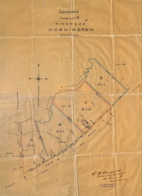
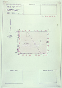
Plan, Subdivision of Crown Lot 19, Ringwood, Victoria - circa 1915
Surveyor's map on wax paperSubdivision map includes Mullum Creek, Government Road to Anderson's Creek, later Warrandyte Road, Government Road to Lillydale, later Whitehorse Road, small creek bridge, later Sandy Creek at Ringwood Lake. Buildings marked include Roman Catholic Church, O.J. Pratt's House and Pratt's butcher shop (photos attached). Map by A.B. Bruford & Co., Licensed Surveyor, 47 Queen Street, Melbourne. -
 Ringwood and District Historical Society
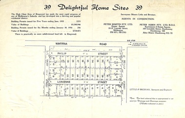
Flyer, Subdivision advertisement for sale of home sites - Ringwood, Victoria - 1956
Cardboard-backed advertisement for 39 home sites for sale, with location map, and summary of local real estate statistics in 1955 & 1956. Handwritten date noted in top right corner - 24th March, 1956.Subdivision map includes Reilly Street, Philip Street, Lorienne Street and Daisy Street in Heathmont. Surveyors: Messrs Little and Brosnan. Agents in conjunction: Peter Martin Pty. Ltd., Estate Agents, 55-57 Latrobe Street, Melbourne (Phone) FB 3571, FB 2783, and Peter Aubin Pty. Ltd., Auctioneers & Estage Agents, 345 Lonsdale Street, Dandenong (Phone) Dandenong 340, after hours Dandenong 932, 70. -
 Ringwood and District Historical Society
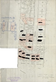
Document, Map showing numbered subdivision allotments with hand-written notations and redactions - 1924
Foolscap size page Map by Arnold Wilson & Associates, Engineers & Surveyors, 399 St.Kilda Road, Melbourne, Tel 26-1840 - 1924/4. Subdivision includes Ilford Road, Karen Court, Washusen Road and Dirkala Avenue, Heathmont. Also includes hand-drawn allotments on Canterbury Road and Balfour Avenue. Page rubber-stamped by building company A & C Jaworski, Office 2, 23 Ringwood Street, Ringwood 3134, Tel 870-0820, A.H. 870-2062. -
![Map, Plan of Subdivision [Allotments along Lerderderg, George and McFarland Streets]](/media/collectors/5e461d8021ea67224c82f2a1/items/675d7243165f146b8adfc656/item-media/675d72d7165f146b8adfc859/item-fit-380x285.jpg) Bacchus Marsh & District Historical Society
Bacchus Marsh & District Historical SocietyMap, Plan of Subdivision [Allotments along Lerderderg, George and McFarland Streets]
This map shows allotments of land on the northern side of Lerderderg Street from Gisborne Road through to the approximate site of the present day Bacchus Marsh Primary School. There are also allotments shown on the southern side of McFarland Street between George Street and Gisborne Road. Larger allotments of land are shown extending northwards towards Masons Lane. Inscribed at the top of the map are the words, 'Plan of Subdivision of Cr Pors (Crown Portions) 12 & 13 & Allotments 1,2,3,4, Block 3, Parish of Korkuperrimul, County of Bourke'. The date of the map has not been established but the absence of the Bacchus Marsh Primary School on the map suggests it may have been produced prior to 1865 when the primary school was built in Lerderderg Street.Single page map showing house block size land allotments in the Lerderderg, George Street and McFarland Street area of Bacchus Marsh with larger allotments north of this area towards Masons Lane also shown. Scale 150 feet to 1 inch. Part of a set of maps which are pasted into a bound volume containing 76 maps or plans in total. High resolution digital image stored on BMDHS computer network. bacchus marsh victoria maps, lerderderg street land allotments, mcfarland street land allotments -
 Ringwood and District Historical Society
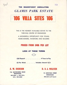
Flyer, Land Sale Brochure, Glamis Park Estate (Wantirna, Vic.) - 1959
Street name Carnarvon Avenue on the subdivision plan became Selkirk Avenue at some stage during or subsequent to development of the Estate.Bi-folded advertisement for sale of residential allotments, including summary of subdivision features and local facilities.Subdivision includes Wantirna streets - Wantirna Road, Carnarvon Avenue, Inchcape Avenue, St Thomas Avenue, St Davids Drive, Dudley Avenue, Angus Avenue. Agents - A.W. Dickson, 136 Whitehorse Road, Ringwood, Telephone WU 6007, WU 7016, A.H. WU 6868. D. & J. Walker, 18 Junction Street, Ringwood, Telephone WU 6516 (all hours). -
 Ringwood and District Historical Society
Plan, Ringwood Station Estate, Subdivision, Ringwood, Victoria - circa 1925
ID 5224 note: Further information relating to squares marked H, F, G, J, and K included in ID 5225 - Ringwood Shop and Dwelling Estate.Hand drawn plan of Ringwood Station Estate showing allotments for sale, with two typed pages attached showing land title information and sale prices.Drawn by Edyth Greenwood, phone 988 Central. Subdivision includes Station Street, Pitt Street, Bedford Road, Wantirna Road, James Street, William Street (later Kendall Street), Greenwood Avenue, Ellison Street, and Haig Street. Circles denote blocks for sale. Squares denote house properties for sale. Other features marked include location of businesses along Main Street (Maroondah Highway), cool store, railway station, shop and police station on Bedford Road, church on Station Street, site of schoolmaster's residence and State School, and location of proposed public baths. Ryner & Langford, Solicitors -
 Ringwood and District Historical Society
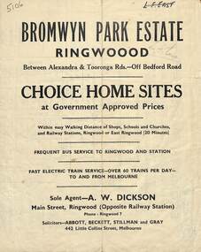
Flyer, Bromwyn Park Estate, Ringwood - 1946 - Avertising Brochures and Map
Two pages of subdivision features, services and locationSubdivision plan includes Alexandra Road, Marwarra Street, Tooronga Road, Hilary Grove, Morcom Avenue. -
 Bendigo Historical Society Inc.
Map - KAMAROOKA STATE FOREST, 23/11/1910
Map: Part of Subdivision of kamarooka State Forest, Parishes of Neilborough and Whirrakee, County of Bendigo. Parish plan (number 287 in map cupboard 1)map, bendigo, subdivision, kamarooka state forest, subdivision, whirrakee -
 Ringwood and District Historical Society
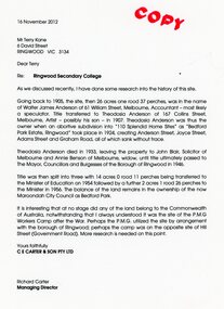
Document - Folder, Brief history of the Ringwood Secondary College site in Bedford Road, Ringwood, Victoria, since 1905 and subdivision in 1924
Terry Kane and Richard Carter were the authors of the short historyType written notes and plans pertaining to the land titles and history of the Ringwood Secondary College site from 1905, prior to the land being sold by the Borough of Ringwood in 1954 to the Education Department. Transcript of covering letter from Richard Carter to Mr T Kane dated 16 November 2012 - "Re: Ringwood Secondary College As we discussed recently, I have done some research into the history of the site. Going back to 1905, the site, then 26 acres one rood 37 perches, was in the name of Walter James Anderson of 61 William Street, Melbourne, Accountant - most likely a speculator. Title transferred to Theodosia Anderson of 167 Collins Street, Melbourne, Artist - possibly his son - In 1907. Theodosia Anderson was thus the owner when on abortive subdivision Into "110 Splendid Home Sites" as "Bedford Park Estate, Ringwood" took place In 1924, creating Anderson Street, Joyce Street, Adams Street and Graham Road, all of which sank without trace. Theodosia Anderson died In 1933, leaving the property to John Blair, Solicitor of Melbourne and Annie Benson of Melbourne, widow, until title ultimately passed to The Mayor, Councillors and Burgesses of the Borough of Ringwood In 1946. Title was then spilt Into three with 14 acres 0 rood 11 perches being transferred to the Minister of Education on 1954 followed by a further 2 acres 1 rood 26 perches to the Minister In 1956. The balance of the land remains In the ownership of the now Maroondoh City Council as Bedford Park. It Is Interesting that at no stage did any of the land belong to the Commonwealth of Australia, notwithstanding that I always understood It was the site of the P.M.G. Workers Camp after the War. Perhaps the P.M.G. utilized the site by arrangement with the borough of Ringwood; perhaps the camp was on the opposite site of Hill Street (Government Road). More research Is needed on this point. Yours faithfully, CE CARTER & SON PTY LTD Richard Carter Managing Director" -
 Surrey Hills Historical Society Collection
Photograph, Subdivision sale of Black's Mont Albert farm in 1924, 1924
Photo was taken in 1924 when the land was subdivided. Black's dairy farm occupied the area just east of Hamilton Street to near Elgar Road. It was subdivided into 88 house allotments along Churchill Street, Bruce Street, Black Street, Proudfoot Street and View Street. The solicitors were Proudfoot & Horton, 360 Collins Street; estate agents were Duncan & Weller, 29 Queen Street. The real estate subdivision notice on the SLV website states that Neil Black had been the owner for 50 years. To date no trace of a Neil Black has been found. Box Hill rate books simply give BLACK as the owner in 1877 (no first name); the entry for 1878-1884 states Robert Black. The 1909 electoral roll has entries for Mont Albert Road for Robert Black (farmer), Thomas Black (carter) & Elizabeth Black (HD). The 1912 electoral roll has entries for Mont Albert Road for Robert Black (farmer), Thomas Black (labourer), John Arthur Black (carter) & Elizabeth Black (HD). Robert Black died in 1920 (b. 1836) and is buried in Box Hill Cemetery (CE-*-0057). His parents were John and Margaret Black. He married Lizzie Foley in 1878. She was the daughter of Margaret & John Foley, born in 1859. She died in 1902 aged 43 years and is buried in the same grave, although the cemetery records record her age as 0 years (presumably as no age or date of birth were given at the time of burial). Children: 1. James Hughbert (1880-1954) 2. John Arthur (1881-1959) 3. Alice (1882-1883) - died aged 6 months 4. Laura Elizabeth (1883-1951) 5. Thomas (1885-1965) 6. Isabella (1887-1963) 7. Eleanor (1889-1963) 8. Ada Maud (1890-1968) 9. Robert (1892-1930). BDM Victoria states places of birth as Box Hill, Surrey Hills or Mont Albert. Many of the family are buried in Box Hill Cemetery. None of the girls appear to have married. Communication from a descendant of John Arthur Black gives the following: "John Arthur Black, son of Robert & Lizzie Foley, married Gladys Anne Layton had 4 children, Robert, Elenore, Marion (Follett) & Annie; they had farm on Stud Road, Dandenong where they milked 30 cows that he retired to after being a earth-moving contractor with draft horses and dug irrigation ditches around Shepparton." This is important as documentation of the area's transformation from farming land to residential land use.Black and white photo of a large 3-poled tent in an area of flat land with eucalypts in the background. There is a large crowd of people, mainly men but also women and children. There are also 3 cars to the RHS.black's dairy farm, dairying, farms, churchill street, black street, proudfoot street, bruce street, view street, neil black, proudfoot & horton, duncan & weller, robert black, lizzie black, lizzie foley, james hubert black, john arthur black, alice black, laura elizabeth black, thomas black, isabella black, eleanor black, ada maud black, robert black jnr, box hill cemetery, land sales -
 Ringwood and District Historical Society
Pamphlet, Subdivisional Auction Sale, Bedford Park, Ringwood - 1924
Bedford Park subdivisional development did not eventuate. The land adjoining the railway line became parkland with provision for sporting facilities and the remainder was purchased by the Education Department as the site for Ringwood High School/Secondary College. Double sided bifolded auction sale advertisement including subdivision features and local facilitiesSubdivision plan includes Bedford Road, Graham Road, Joyce Street, Anderson Street, and Adams Street -
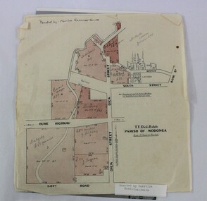 Wodonga & District Historical Society Inc
Map - Hamilton-Smith Collection Subdivision Map of Wodonga
The Hamilton-Smith collection was donated by the children of Grace Mary Hamilton-Smith nee Ellwood (1911-2004) and John Hamilton-Smith (1909-1984) who settled in Wodonga in the 1940s. The Ellwood family had lived in north-east Victoria since the late 1800s. Grace’s mother, Rosina Ellwood nee Smale, was the first teacher at Baranduda in 1888, and a foundation member of the C.W.A. Rosina and her husband Mark retired to Wodonga in 1934. Grace and John married at St. David’s Church, Albury in 1941. John was a grazier, and actively involved in Agricultural Societies. The collection contains significant items which reflect the local history of Wodonga, including handmade needlework, books, photographs, a wedding dress, maps, and material relating to the world wars. This item has well documented provenance and a known owner. It forms part of a significant and representative historical collection which reflects the local history of Wodonga. It contributes to our understanding of social and family life in early twentieth century Wodonga, as well as providing interpretative capacity for themes including local history and social history. A printed map of a Wodonga subdivision with hand written annotations On top proper right corner: "Donated by Merrilyn Hamilton-Smith". map, subdivision, wodonga, local history, maps, hamilton-smith, hamilton-smith collection -
Whitehorse Historical Society Inc.
Map, Shire of Blackburn and Mitcham, 1928
Combination of two sheets of detailed map.Combination of two sheets of detailed map. Many subdivisions shown in details with lot numbers.Combination of two sheets of detailed map. maps, shire of blackburn and mitcham -
 Kew Historical Society Inc
Plan - Subdivision Plan, Six Big Home Sites, Camberwell North, c.1936
Subdivision plans are historically important documents used as evidence of the growth of suburbs in Australia. They frequently provide information about when the land was sold on which a built structure was subsequently constructed as well as evidence relating to surveyors and real estate and financial agents. The numerous subdivision plans in the Kew Historical Society's collection represent working documents, ranging from the initial sketches made in planning a subdivision to printed plans on which auctioneers or agents listed the prices for which individual lots were sold. In a number of cases, the reverse of a subdivision plan in the collection includes a photograph of a house that was also for sale by the agent. These photographs provide significant heritage information relating house design and decoration, fencing and household gardens.A subdivision in what is currently Balwyn, but which was advertised as being in Camberwell North. The subdivision included six allotments facing Buchanan Avenue and Houghton Street. The subdivision was to the east of the Pointed Firs Estate (1936). In addition to the intrinsic value of this subdivision plan, it also reveals information about the development of transport infrastructure in this area. The subdivision plan notes that the Tramways Board has approved the extension of the tram route past the current terminus at Balwyn Road.subdivision plans - camberwell -
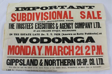 Wodonga & District Historical Society Inc
Poster - Hamilton-Smith Collection Wodonga Subdivision Poster
The Hamilton-Smith collection was donated by the children of Grace Mary Hamilton-Smith nee Ellwood (1911-2004) and John Hamilton-Smith (1909-1984) who settled in Wodonga in the 1940s. The Ellwood family had lived in north-east Victoria since the late 1800s. Grace’s mother, Rosina Ellwood nee Smale, was the first teacher at Baranduda in 1888, and a foundation member of the C.W.A. Rosina and her husband Mark retired to Wodonga in 1934. Grace and John married at St. David’s Church, Albury in 1941. John was a grazier, and actively involved in Agricultural Societies. The collection contains significant items which reflect the local history of Wodonga, including handmade needlework, books, photographs, a wedding dress, maps, and material relating to the world wars. This item has well documented provenance and a known owner. It forms part of a significant and representative historical collection which reflects the local history of Wodonga. It contributes to our understanding of social and family life in early twentieth century Wodonga, as well as providing interpretative capacity for themes including local history and social history. A white poster with black and red text advertising a subdivision sale sale, subdivision, wodonga, land, building, development, hamilton-smith, hamilton-smith collection -
 Eltham District Historical Society Inc
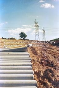
Photograph (Item) - Print, Angela Wall, New Subdivision - Reynolds Road, 1988
Angela Wall 1988 Entrant No. 129 Ref: Series 34, Items 30, 101, 102 SHIRE OF ELTHAM COMMUNITY PHOTOGRAPHIC SURVEY Photography is an artform which many of us practice, sometimes purely for artistic pursuit, sometimes to record the people and events in our lives. In 1988, as part of a local Bicentennial project, the Shire of Eltham conducted the Eltham Community Photographic Survey. Up to 100 entries were to be selected by a panel of photographers for entry into the Eltham Photographic Survey Exhibition. Entries had to be submitted by May 13, 1988. Entrants whose images were selected for the exhibition were contacted and requested to further submit an entry form providing entrant’s name, area of residence, age, and proposed captions. These details were then used to produce labels for the exhibition mounts. Where negatives had not been supplied, these were requested to support the display of printed enlargements mounted on 10” x 8” cardboard. The mounted prints were made available post exhibition for sale at $8.50 each for colour prints and $7.00 for B&W prints. Residents in the Shire were invited to collect a free roll of film and take a photograph of what they either liked or did not like about the area. A total of 160 entrants submitted multiple entries for the exhibition. Of those selected for exhibition, entrants ranged in age from 9 to 70 years. All custom colour and black and white printing for the exhibition was completed by Wattle Studios of Eltham. The Eltham Photographic Survey was jointly auspiced by the Shire of Eltham and Wattle Studios, of 953 Main Road, Eltham. The project was greatly assisted by: • David McRitchie, Media Studies Lecturer Victoria College, Rusden Campus. • Ian and Annette Toohill of Wattle Studios • Tracy Naughton, Eltham Community Arts Officer • Neville Emerson Pty. Ltd. • Superior Press, Eltham • Kodak Australasia Pty. Ltd. • Agfa Gevaert Ltd. • Townsend Colourtech Pty. Ltd. • The Australian Bicentennial Authority • Eleanor Bowers, Secretary, Eltham Arts Council The exhibition was placed on display in the Woolworths Arcade, Eltham between Monday June 6th and Saturday June 11, 1988. It was also intended to hold the exhibition at a venue in the Shire’s North Riding from Monday, June 20 to Friday June 24. It was then displayed at the Were Street Theatre, Montmorency from Friday, June 24 to Thursday, July 7. Series 34: Eltham Community Photographic Survey 1988 - Prints & Documentation Series consists of 117 photographs of Shire scenes taken by members of the community. Items I - 41 are larger photographs mounted on card, which were exhibited. Items 42 - 117 are unmounted copies, alternative takes and other entries. Corresponding negatives contained in Series 35: Eltham Community Photographic Survey 1988 – Negatives which consists of 267 colour and B&W negatives and one colour slide of Shire scenes taken by members of the community. The negatives are arranged by the entrant number of the photographer. The Eltham Community Photographic Survey collection is significant to the local community as it was curated by the local community - ordinary people of all ages - representing what they liked and did not like in the area where they lived. It represents an unfiltered representation of the Shire of Eltham as it was in 1988. It also represents one of many projects as part of the national programme of events and celebrations to commemorate the bicentenary. It is a time capsule of life in the 1980s of this urban and rural municipality in Melbourne's north. Front: Entrant No. and name on printed label Rear: Entrant No., name and address on printed label; also 'Series 34' and the 'Item No.' in pencilshire of eltham archives, bicentennial project, eltham, eltham community photographic survey, eltham photographic survey exhibition, series 34, series 35, angela wall, film - kodak ga 100 5095, housing estate, power transmission lines, real estate development, research (vic.), reynolds road, scan - 35mm negative, subdivison lots -
 Eltham District Historical Society Inc
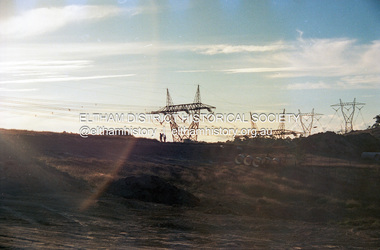
Photograph (Item) - Print, Sean Brady, Untitled (New Subdivision), 1988
Sean Brady 1988 Entrant No. 145 Ref: Series 34, Items 33, 34, 105, 106 SHIRE OF ELTHAM COMMUNITY PHOTOGRAPHIC SURVEY Photography is an artform which many of us practice, sometimes purely for artistic pursuit, sometimes to record the people and events in our lives. In 1988, as part of a local Bicentennial project, the Shire of Eltham conducted the Eltham Community Photographic Survey. Up to 100 entries were to be selected by a panel of photographers for entry into the Eltham Photographic Survey Exhibition. Entries had to be submitted by May 13, 1988. Entrants whose images were selected for the exhibition were contacted and requested to further submit an entry form providing entrant’s name, area of residence, age, and proposed captions. These details were then used to produce labels for the exhibition mounts. Where negatives had not been supplied, these were requested to support the display of printed enlargements mounted on 10” x 8” cardboard. The mounted prints were made available post exhibition for sale at $8.50 each for colour prints and $7.00 for B&W prints. Residents in the Shire were invited to collect a free roll of film and take a photograph of what they either liked or did not like about the area. A total of 160 entrants submitted multiple entries for the exhibition. Of those selected for exhibition, entrants ranged in age from 9 to 70 years. All custom colour and black and white printing for the exhibition was completed by Wattle Studios of Eltham. The Eltham Photographic Survey was jointly auspiced by the Shire of Eltham and Wattle Studios, of 953 Main Road, Eltham. The project was greatly assisted by: • David McRitchie, Media Studies Lecturer Victoria College, Rusden Campus. • Ian and Annette Toohill of Wattle Studios • Tracy Naughton, Eltham Community Arts Officer • Neville Emerson Pty. Ltd. • Superior Press, Eltham • Kodak Australasia Pty. Ltd. • Agfa Gevaert Ltd. • Townsend Colourtech Pty. Ltd. • The Australian Bicentennial Authority • Eleanor Bowers, Secretary, Eltham Arts Council The exhibition was placed on display in the Woolworths Arcade, Eltham between Monday June 6th and Saturday June 11, 1988. It was also intended to hold the exhibition at a venue in the Shire’s North Riding from Monday, June 20 to Friday June 24. It was then displayed at the Were Street Theatre, Montmorency from Friday, June 24 to Thursday, July 7. Series 34: Eltham Community Photographic Survey 1988 - Prints & Documentation Series consists of 117 photographs of Shire scenes taken by members of the community. Items I - 41 are larger photographs mounted on card, which were exhibited. Items 42 - 117 are unmounted copies, alternative takes and other entries. Corresponding negatives contained in Series 35: Eltham Community Photographic Survey 1988 – Negatives which consists of 267 colour and B&W negatives and one colour slide of Shire scenes taken by members of the community. The negatives are arranged by the entrant number of the photographer. The Eltham Community Photographic Survey collection is significant to the local community as it was curated by the local community - ordinary people of all ages - representing what they liked and did not like in the area where they lived. It represents an unfiltered representation of the Shire of Eltham as it was in 1988. It also represents one of many projects as part of the national programme of events and celebrations to commemorate the bicentenary. It is a time capsule of life in the 1980s of this urban and rural municipality in Melbourne's north. Front: Entrant No. and name on printed label Rear: Entrant No., name and address on printed label; also 'Series 34' and the 'Item No.' in pencilshire of eltham archives, bicentennial project, eltham, eltham community photographic survey, eltham photographic survey exhibition, series 34, series 35, scan - 35mm negative, film - kodak ga 100 5095, housing estate, power transmission lines, real estate development, sean brady, subdivison lots -
 Eltham District Historical Society Inc
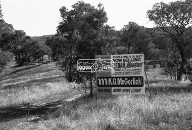
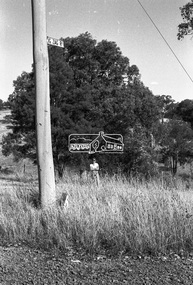
Negative - Photograph, Shire of Eltham, Eltham Meadows Estate, Zig Zag Road subdivision, Jan. 1980
eltham, eltham meadows estate, k.g. mcgorlick pty ltd, mcgorlick real estate, zig zag road subdivision -
 Eltham District Historical Society Inc
Negative - Photograph, Shire of Eltham, Eltham Meadows Estate, Zig Zag Road subdivision, Jan. 1980
eltham, eltham meadows estate, k.g. mcgorlick pty ltd, mcgorlick real estate, zig zag road subdivision -
 Eltham District Historical Society Inc
Negative - Photograph, Shire of Eltham, Eltham Meadows Estate, Zig Zag Road subdivision, Jan. 1980
eltham, eltham meadows estate, k.g. mcgorlick pty ltd, mcgorlick real estate, zig zag road subdivision -
 Eltham District Historical Society Inc
Negative - Photograph, Shire of Eltham, Eltham Meadows Estate, Zig Zag Road subdivision, Jan. 1980
eltham, eltham meadows estate, k.g. mcgorlick pty ltd, mcgorlick real estate, zig zag road subdivision -
 Eltham District Historical Society Inc
Negative - Photograph, Shire of Eltham, Eltham Meadows Estate, Zig Zag Road subdivision, Jan. 1980
eltham, eltham meadows estate, k.g. mcgorlick pty ltd, mcgorlick real estate, zig zag road subdivision -
 Eltham District Historical Society Inc
Negative - Photograph, Shire of Eltham, Eltham Meadows Estate, Zig Zag Road subdivision, Jan. 1980
eltham, eltham meadows estate, k.g. mcgorlick pty ltd, mcgorlick real estate, zig zag road subdivision -
 Eltham District Historical Society Inc
Negative - Photograph, Shire of Eltham, Eltham Meadows Estate, Zig Zag Road subdivision, Jan. 1980
eltham, eltham meadows estate, k.g. mcgorlick pty ltd, mcgorlick real estate, zig zag road subdivision -
 Eltham District Historical Society Inc
Slide - Photograph, Eltham Shire Council, Plan of Subdivision, Crown Allotment 8, Section 8A, Parish of Nillumbik,County of Evelyn, 1969
35mm colour positive transparency blue Agfacolour Service plastic mountC1, Pain, Sibbel and Carter, Research-Warrandyte Road, North Warrandyte, 4 August 1969carter, infrastructure, map, north warrandyte, pain, parish of nillumbik, plan of subdivision, planning, research-warrandyte road, sibbel, subdivison lots -
 Eltham District Historical Society Inc
Slide - Photograph, Eltham Shire Council, Plan of Subdivision of Part of Crown Allotment 4, Section 2 at Kangaroo Ground, Parish of Nillumbik, County of Evelyn, 1969
35mm colour positive transparency blue Agfacolour Service plastic mountC6, Kimse, Kangaroo Ground-St Andrews Road, 4 August 1969infrastructure, kangaroo ground, kangaroo ground-st andrews rd, kimse, map, plan of subdivision, planning, subdivison lots -
 Eltham District Historical Society Inc
Slide - Photograph, Eltham Shire Council, Plan of Subdivision, Part of Crown Portion 3, Parish of Nillumbik, County of Bourke, 1969
35mm colour positive transparency blue Agfacolour Service plastic mountC5C, Delbridge, 4 lots, Rattray Road, 4 August 1969infrastructure, map, montmorency, planning, rattray road, subdivison lots, reichelt avenue -
 Eltham District Historical Society Inc
Slide - Photograph, Eltham Shire Council, Tentative plan of subdivision, part of Crown Allotment 22, Section B, Parish of Greensborough, County of Evelyn, 1969
35mm colour positive transparency blue Agfacolour Service plastic mountE11, N1069, Stogryn, Sub 'prop',infrastructure, map, planning, subdivison lots -
 Eltham District Historical Society Inc
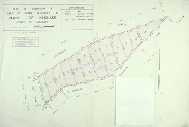
Slide - Photograph, Eltham Shire Council, Plan of subdivision of Part of Crown Allotment 41, Parish of Kinglake, County of Anglesey, 1969
35mm colour positive transparency blue Agfacolour Service plastic mountC8, N. Johnson, Kinglake-Glenburn Road, 4 August 1969infrastructure, map, planning, subdivison lots, n. johnson, kinglake-glenburn road, kinglake