Showing 1526 items
matching aerial photograph
-
 Bayside Gallery - Bayside City Council Art & Heritage Collection
Photograph, Department of Crown Lands and Survey, Victoria, Brighton, Elwood and Elsternwick, c. 1965-71
... Aerial photograph.... This aerial photograph shows parts of Brighton, Elwood and Elsternwick...Black and white photograph. An aerial photograph showing... and Survey Aerial photograph Bayside Port Phillip Bay Map ...The Department of Crown Lands and Survey (1857-1983) was responsible for the administration of survey and mapping and the sale, occupation and management of crown land throughout its existence. This aerial photograph shows parts of Brighton, Elwood and Elsternwick and was taken circa 1965-71.brighton, department of crown lands and survey, aerial photograph, bayside, port phillip bay, map, cartographic material, elwood, elsternwick, elsternwick park, elwood tram depot, elwood pier, new street, glen huntly road, st kilda street, nepean highway -
 Bendigo Historical Society Inc.
Photograph - FORTUNA COLLECTION: AERIAL PHOTOGRAPH OF FORTUNA VILLA
... FORTUNA COLLECTION: AERIAL PHOTOGRAPH OF FORTUNA VILLA...Colour aerial photograph of Fortuna Villa, with Victoria... BENDIGO Streetscape fortuna Colour aerial photograph of Fortuna ...Colour aerial photograph of Fortuna Villa, with Victoria Hill visible in background. Chum Street in foreground of image. Many cars parked in areas around Fortuna Villa, probably indicating that his photo was taken during the occupation of Fortuna by the Cartographic Division of the Department of Defence.bendigo, streetscape, fortuna -
Port Melbourne Historical & Preservation Society
Photograph - Double-sided aerial photograph, Hobson's Bay and the Yarra River/Port Phillip and Western Port Bay, Surveyor General and Director of Mapping, Apr 1990
... Double-sided aerial photograph, Hobson's Bay and the Yarra... sided aerial photographs), framed and with timber display stand... Phillip and Western Port (double sided aerial photographs), framed ...Landsat imagery - an extract from the atlas of VictoriaAerial photos of Port Phillip and Western Port (double sided aerial photographs), framed and with timber display stand. 1995 side A: Hobson's Bay and Yarra River - aerial photo mosaic; side B. Port Phillip and Western Port Bays - satellite photomelbourne harbor trust - port of melbourne authority -
 Mission to Seafarers Victoria
Photograph - Aerial Photograph, 1980-1997
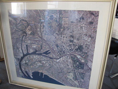
... Aerial Photograph...Large framed and glazed print of aerial colour photograph... Photograph Aerial Photograph ...Aerial view of Melbourne pre October 1997 as the Docklands stadium, landmark of the new precinct is not yet built.Large framed and glazed print of aerial colour photograph of the Yarra river and Docklands, C - 1982 - 1995 docklands, melbourne, aerial view, yarra river, city, port melbourne, albert park -
 Bayside Gallery - Bayside City Council Art & Heritage Collection
Photograph, Department of Crown Lands and Survey, Victoria, Melbourne Project: Brighton, 1976
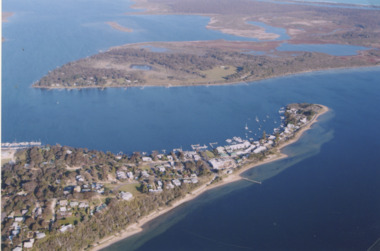
... Aerial photograph.... This aerial photograph shows parts of Brighton and was taken on 1...Black and white photograph. An aerial photograph showing... Brighton Department of Crown Lands and Survey Aerial photograph ...The Department of Crown Lands and Survey (1857-1983) was responsible for the administration of survey and mapping and the sale, occupation and management of crown land throughout its existence. This aerial photograph shows parts of Brighton and was taken on 1 December 1976brighton, department of crown lands and survey, aerial photograph, bayside, port phillip bay, map, cartographic material, melbourne project 1976, brighton yacht club, middle brighton baths, north road, st kilda street, new street -
 Bayside Gallery - Bayside City Council Art & Heritage Collection
Photograph, Department of Crown Lands and Survey, Victoria, Melbourne Project: Brighton and Hampton, 1976
... Aerial photograph.... This aerial photograph shows parts of Brighton and Hampton...Black and white photograph. An aerial photograph showing... Hampton Street Black and white photograph. An aerial photograph ...The Department of Crown Lands and Survey (1857-1983) was responsible for the administration of survey and mapping and the sale, occupation and management of crown land throughout its existence. This aerial photograph shows parts of Brighton and Hampton and was taken on 1 December 1976. brighton, department of crown lands and survey, aerial photograph, bayside, port phillip bay, map, cartographic material, melbourne project 1976, brighton yacht club, middle brighton baths, hampton, green point, brighton beach, south road, the esplanade, hampton street -
 Bayside Gallery - Bayside City Council Art & Heritage Collection
Photograph, Department of Crown Lands and Survey, Victoria, Melbourne Project: Brighton, Hampton, Sandringham, 1976
... Aerial photograph.... This aerial photograph shows parts of Brighton, Hampton...Black and white photograph. An aerial photograph showing... and Survey Aerial photograph Bayside Port Phillip Bay Map ...The Department of Crown Lands and Survey (1857-1983) was responsible for the administration of survey and mapping and the sale, occupation and management of crown land throughout its existence. This aerial photograph shows parts of Brighton, Hampton and Sandringham and was taken on 1 December 1976brighton, department of crown lands and survey, aerial photograph, bayside, port phillip bay, map, cartographic material, hampton, sandringham, green point, sandringham yacht club, south road, beach road, hampton street, melbourne project 1976 -
 Bayside Gallery - Bayside City Council Art & Heritage Collection
Photograph, Department of Crown Lands and Survey, Victoria, Melbourne Project: Brighton and Elwood, 1976
... Aerial photograph.... This aerial photograph shows parts of Brighton and Elwood...Black and white photograph. An aerial photograph showing... Aerial photograph Elsternwick Park Point Ormond North Road Ormond ...The Department of Crown Lands and Survey (1857-1983) was responsible for the administration of survey and mapping and the sale, occupation and management of crown land throughout its existence. This aerial photograph shows parts of Brighton and Elwood and was taken on 1 December 1976brighton, elwood, department of crown lands and survey, aerial photograph, elsternwick park, point ormond, north road, ormond esplanade, st kilda street, glen huntly road, bayside, port phillip bay, map, cartographic material, melbourne project 1976 -
 Greensborough Historical Society
Aerial Photograph, Greensborough aerial with property overlay, 1945_
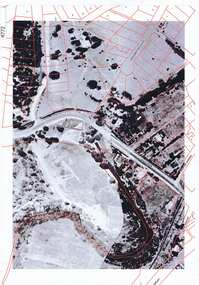
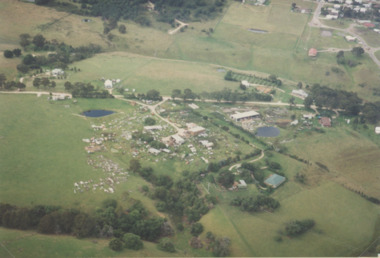
... Aerial Photograph...Enlargements of section of 1945 aerial survey photographs... aerial survey photographs of central Greensborough, with property ...Enlargements of section of 1945 aerial survey photographs of central Greensborough, with property overlay boundaries and some street numbers by Noel WithersTwo photocopied enlargements with property overlay markingsStreet names and some property numbers. Overlays by Noel Withers.greensborough, plenty river -
 Greensborough Historical Society
Newspaper clipping, Greensborough shopping centre 1970, 1970_
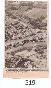
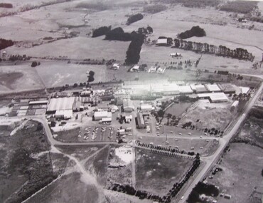
... aerial photograph...A black and white newspaper clipping featuring an aerial.... greensborough streets greensborough aerial photograph 1970 partington ...The photograph is of the centre of Greensborough in 1970, prior to the Greensborough Plaza being built. The Partington farm house, named 'Alwyn' (after Alan and Wyn Partington) can be seen north of the Railway Line. Alan and Wyn had to leave this farm in 1976 - moving to a new house - built by son Gary - at 54 Manatunga Circuit - to make way for the creation of Whatmough Park and development of the Hailes Street-The Circuit-Greensborough Plaza precinct.This is an important visual record of Greensborough before the redevelopment of the late 1970's. It also shows the Whatmough park area when it was still the Partington family farm.A black and white newspaper clipping featuring an aerial photograph.Nilgreensborough streets, greensborough, aerial photograph, 1970, partington, whatmough park, greensborough swimming pool -
 Department of Health and Human Services
Photograph, Ariel view Colanda grounds (circa 2000)
... , disability, aerial photograph, digitised photograph...Digitised colour aerial photograph of the Colanda Centre..., disability, aerial photograph, digitised photograph Digitised colour ...The Colac, Victoria-based Colanda Centre was one of the last Victorian institutions and offered disability accommodation from 1976, when it was established, until 2019, with its closure. Digitised colour aerial photograph of the Colanda Centre in Colac, Victoria. colanda, colac, disability services, residential services, disability, aerial photograph, digitised photograph -
 Phillip Island and District Historical Society Inc.
Photograph, R.A.A.F, 1939
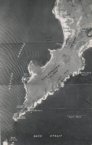
... aerial photograph of summerland island...Aerial Photograph of the western end of Phillip Island... Island local history photography aerial photograph of summerland ...One of a collection of over 400 photographs in an album commenced in 1960 and presented to the Phillip Island & Westernport Historical Society by the Shire of Phillip IslandAerial Photograph of the western end of Phillip Island taken by the RAAF in 1939 from 13,000 feet.local history, photography, aerial photograph of summerland island, black & white photograph, coastline, beaches, the nobbies, john jenner, bryant west -
 Phillip Island and District Historical Society Inc.
Photograph, R.A.A.F, 1939
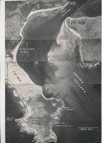
... aerial photograph...Aerial Photograph of eastern end of Phillip Island... Island local history photography aerial photograph eastern ...One of a collection of over 400 photographs in an album commenced in 1960 and presented to the Phillip Island & Westernport Historical Society by the Shire of Phillip IslandAerial Photograph of eastern end of Phillip Island and the Eastern Passage taken by the RAAF in 1939 at 13,000 feet.local history, photography, aerial photograph, eastern passage, cape woolamai, black & white photograph, coastline, r.a.a.f., john jenner, bryant west -
Lakes Entrance Historical Society
Photograph, 14/04/2013 12:00:00 AM
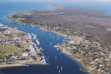
... Aerial Photograph...Colour aerial photograph of Entrance at New Works showing... Entrance gippsland Aerial Photograph Waterways Topography New Works ...Colour aerial photograph of Entrance at New Works showing the sand transfer building Lakes Entrance VictoriaNew Worksaerial photograph, waterways, topography -
Glenelg Shire Council Cultural Collection
Photograph - Photograph - aerial view of Portland harbour, n.d
... Photograph - aerial view of Portland harbour...Black and white aerial photograph of Portland Harbour... Authority Port of Portland Archives aerial photography Portland ...Port of Portland AuthorityBack: Harb022, pencil bottom right.port of portland archives, aerial photography, portland harbour -
 Lakes Entrance Historical Society
Photograph - McMillan Strait, 2005 c
... Aerial Photograph...Colour aerial photograph of McMillan Strait between...Aerial Photograph Township Colour aerial photograph ...Colour aerial photograph of McMillan Strait between Paynesville on left and Raymond Island on right on Gippsland Lakes Victoriaaerial photograph, township -
Clunes Museum
Photograph, EXTENT OF MINE WORKINGS AT CLUNES, 1987
... AERIAL PHOTOGRAPH...AERIAL PHOTOGRAPH CLUNES GOLD WORKINGS MAP SUPERIMPOSED... WORKINGS IN CLUNES PORT PHILLIP MINE AERIAL PHOTOGRAPH QUARTZ ...MINE WORKINGS IN CLUNESAERIAL PHOTOGRAPH CLUNES GOLD WORKINGS MAP SUPERIMPOSED. MOUNTED ON CARDBOARD WITH DETAILS OF MINE LOCATION. TYPED DESCRIPTION PASTED BELOW.port phillip mine, aerial photograph, quartz mining -
 Lakes Entrance Historical Society
Photograph - Lakes Entrance, Lakes Post Newspaper, 1/01/1993 12:00:00 AM
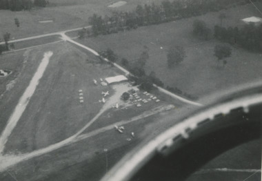
... Aerial Photograph...Black and white aerial photograph of Campbell's Airfield... training at Campbell's Airfield Aerial Photograph Township Black ...DCNR Crews from Bairnsdale Swifts Creek and Nowa Nowa training at Campbell's AirfieldBlack and white aerial photograph of Campbell's Airfield Colquhoun Road showing planes and vehicles near hanger Lakes Entrance Victoriaaerial photograph, township -
 Lakes Entrance Historical Society
Photograph - Metung, 2005 c
... Aerial Photograph...Colour aerial photograph of Shaving Point Gippsland Lakes...Aerial Photograph Settlement Waterways Metung Colour aerial ...Colour aerial photograph of Shaving Point Gippsland Lakes looking eastward over Mosquito Point Bancroft Bay in between Metung Victoriaaerial photograph, settlement, waterways, metung -
 Lakes Entrance Historical Society
Photograph - Lakes Entrance, 1993c
... Aerial Photograph...Colour aerial photograph of Blair Road showing first few...Red brick house on right O'Donnells Aerial Photograph ...Red brick house on right O'DonnellsColour aerial photograph of Blair Road showing first few dwellings of housing estate Tarra Landing in background Lakes Entrance Victoriaaerial photograph, township -
 Warrnambool and District Historical Society Inc.
Photograph - Framed aerial photograph of Warrnambool Woollen Mill, Circa 1970
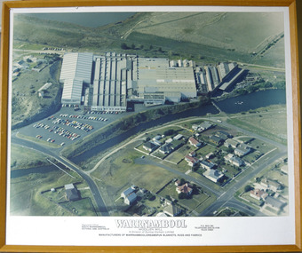
... Framed aerial photograph of Warrnambool Woollen Mill...Aerial colour photograph of the Warrnambool Woollen Mill.... Timber frame Photograph Framed aerial photograph of Warrnambool ...In 1869, the Warrnambool Meat Preserving Company commenced their business on the site, where it operated until 1875 when it was sold to the directors of the Warrnambool Woollen Mill Company. After being destroyed by fire in 1882 it wasn’t until 1910 that the Warrnambool Chamber of Commerce was approached by Marcus Saltau and Peter McGennan to invest in a new mill. The original directors were James Dickson, P J McGennan, Robert Swinton, M Saltau, and J W Younger. In 1955 the Warrnambool Woollen Mill formed a partnership with the Wangaratta Woollen Mills. Dunlop bought the mill in 1968. From that time until its closure in 2000 it had a number of different owners, the last being the Smith Family Industries. The Mill site holds significance for Warrnambool as the site was one of the earliest industries established in the town. The Warrnambool Woollen Mill operated for close to 100 years and in that time forged a strong link with the people of Warrnambool. Its product held a significant position in the marketplace.Aerial colour photograph of the Warrnambool Woollen Mill and surrounding area including carparks. The Merri River crosses from lower left to upper right. Playing field, Jetty Flat, in upper right hand corner and Harris Street bridge in lower left. Aspect is looking easterly. Photo glued to white card mount with text in black underneath. Timber frameWarrnambool Woollen Mill A division of Dunlop Olympic Limited. Manufacturers of Warrnambool/Dreamspun blankets, rugs and fabrics. Registered office South Warrnambool, Victoria. 3280. Australia. P.O. Box 484 Telephone (055)624166. Telex 55820warrnambool, warrnambool woollen mill, woollen mill, dunlop olympic, marcus saltau, p j mcgennan, james dickson, robert swinton, j w younger, dreamspun -
 Greensborough Historical Society
Photograph, Nearmap.com, Nearmap: Greensborough, 27/09/2012
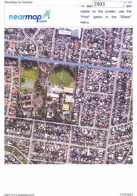
... Aerial photographs of the Watsonia area, land owned...Four coloured aerial photographs... Plenty Lower Plenty melbourne Aerial photographs of the Watsonia ...Aerial photographs of the Watsonia area, land owned by Black and Families, including sites of Loyola College, Loyola Reserve and Gresswell ReserveFour coloured aerial photographswatsonia, black family, loyola college, gresswell forest reserve -
 Glenelg Shire Council Cultural Collection
Photograph - Photograph - Aerial View of Thomas Borthwicks & Sons Meatworks, n.d
... Photograph - Aerial View of Thomas Borthwicks & Sons...Framed, black and white aerial photograph of Thomas... Photograph - Aerial View of Thomas Borthwicks & Sons Meatworks ...On Display at History House.Framed, black and white aerial photograph of Thomas Borthwick & Sons Meatworks PortlandBack: Reg. No 58 -
Glenelg Shire Council Cultural Collection
Photograph - Photograph - aerial view of Portland harbour, n.d
... Photograph - aerial view of Portland harbour...Black and white aerial photograph of Portland Harbour... Harbour Black and white aerial photograph of Portland Harbour ...Port of Portland Authorityport of portland archives, aerial photography, portland harbour -
 Phillip Island and District Historical Society Inc.
Newspaper clippings
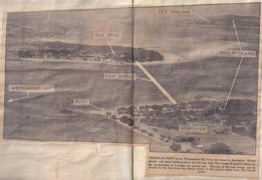
... Aerial photograph in newspaper...Aerial photograph of site of proposed bridge between San...-island-and-the-bass-coast Aerial photograph in newspaper local ...Aerial photograph in newspaperAerial photograph of site of proposed bridge between San Remo and Newhaven.local history, documents, newspapers, bridges, phillip island, black & white newspaper clipping, phillip island. -
 Lakes Entrance Historical Society
Photograph - Lakes Entrance, Gippsland Ports, 2006 c
... Aerial Photograph...Colour aerial photograph showing view of entrance...Aerial Photograph Historic Site Dredging Waterways Lakes ...Colour aerial photograph showing view of entrance to Gippsland Lakes from Bass Strait Reeves Channel Rigby Island and township of Lakes Entrance Victoriaaerial photograph, historic site, dredging, waterways, lakes entrance -
 Lakes Entrance Historical Society
Photograph - Metung, 1995 c
... Aerial Photograph...Colour aerial photograph of Shaving Point Gippsland Lakes...Aerial Photograph Waterways Topography Metung Colour aerial ...Colour aerial photograph of Shaving Point Gippsland Lakes with Mosquito Point bottom left hand corner Boole Poole on opposite shore Metung Victoriaaerial photograph, waterways, topography, metung -
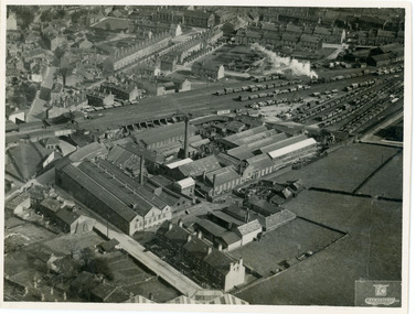 National Wool Museum
Photograph, Geographia Ltd, Unknown
... Aerial photograph of a factory in the UK....Black and white aerial photograph of a factory...-and-the-bellarine-peninsula Aerial photograph of a factory in the UK. wool ...Aerial photograph of a factory in the UK.Black and white aerial photograph of a factory with townhouses in the background in a landscape format.Front bottom right corner - Geographia Ltd, 167 Fleet Street, London, EC4. Back stamped - Neg. No. 3658 Date Subject Bides (?) 631wool, woollen mills, wool manufacture -
Tatura Irrigation & Wartime Camps Museum
Photograph - aerial, Qasco Vic Images, Tatura, 7 March 2002
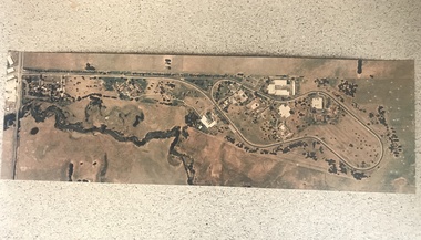
... Photograph - aerial...Large aerial photograph of town of Tatura and approx. 3 kms... Tatura the-murray aerial photographs Tatura Large aerial ...Large aerial photograph of town of Tatura and approx. 3 kms out. Colour, laminated.aerial photographs tatura -
 Lakes Entrance Historical Society
Photograph - North Arm Lakes Entrance, 2005 c
... Aerial Photograph...Colour aerial photograph showing Kalimna in foreground... and 03859.2 sizes 10 x 15 cm and 15 x 10 cm Aerial Photograph ...Also two colour photographs of North Arm area taken from Leigh and Judy Davies Blair Road Lakes Entrance number 03859.1 and 03859.2 sizes 10 x 15 cm and 15 x 10 cmColour aerial photograph showing Kalimna in foreground, North Arm, towhship, Cunninghame Arm and across to ninety mile beach and Bass Strait ocean beach Lakes Entrance Victoriaaerial photograph, settlement