Showing 564 items matching "bacchus"
-
 Bacchus Marsh & District Historical Society
Map, Bacchus Marsh Region Parish Plans: Folded set of maps
... Bacchus Marsh Region Parish Plans: Folded set of maps ...Set of Victorian Lands Department Parish Plans covering the township of Bacchus Marsh and surrounding districts. Folded. BMDHS Location: AR/SU27/D2: Map Drawersmaps bacchus marsh region, bacchus marsh victoria maps, interim record -
 Bacchus Marsh & District Historical Society
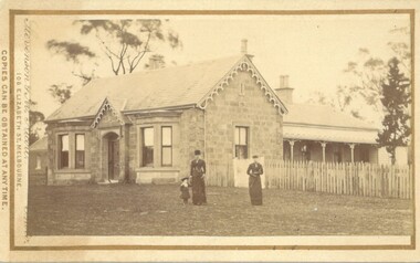
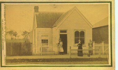
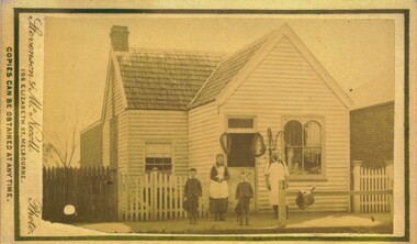
Photograph, Stone Villa house 4 Bennett Street Bacchus Marsh 1883
... Stone Villa house 4 Bennett Street Bacchus Marsh 1883 ...The house depicted in this image was constructed in 1865 for James Young a prominent local businessman and participant in community affairs. James Young left Bacchus Marsh in 1869. In 1870 Stone Villa was purchased by local solicitor Francis Gell. In 1872 it was bought by William Collyer. For a time before 1883 it was used as a school operated by Mr Thomas Kissock and his wife. From 1883 until 1922 it was used as a parsonage by the Church of England. In 1922 it was sold to Frederick Slack as a private residence. Since Slack's ownership there have been other owners. As of April 2024 it remains as a private residence and is listed as a heritage property in the Moorabool Shire planning scheme. The identity of the two women and young girl in the foreground of the image has not been established. One of the women, and the child are possibly the wife and daughter of the Rev A.C. McCausland who was the Church of England Vicar in Bacchus Marsh from 1872 until 1885 and would have resided in this house in 1883 when this picture was produced.An early visual record of one of the most culturally and architecturally significant nineteenth century stone houses in Bacchus Marsh.Small sepia 'carte de visite' style unframed photograph on card with gold border framing photograph. Housed in the album, 'Photographs of Bacchus Marsh and District in 1883 by Stevenson and McNicoll', the Jeremeas Family Album. The photo is of a stone dwelling with an ornate gable above the inset front door which is flanked by two double windows, one of which is a bay window. The gable roof line bears ornate woodwork. A weatherboard extension with verandah has been added to the rear of the house, running north-south. A picket fence lines the block to the side of the dwelling. Two elegantly dressed women, both holding a furled umbrella, stand at the front, one holding the hand of a little girl.Printed On the front: Stevenson & McNicoll. Photo. 108 Elizabeth St. Melbourne. COPIES CAN BE OBTAINED AT ANY TIME. On the back: LIGHT & TRUTH inscribed on a banner surmounted by a representation of the rising sun. Copies of this Portrait can be had at any time by sending the Name and Post Office Money Order or Stamps for the amount of order to STEVENSON & McNICOLL LATE BENSON & STEVENSON, Photographers. 108 Elizabeth Street, MELBOURNE. Hand written on the reverse: 'Stone Villa built by James Young 1860 (sic) as his private residence, later as a school (Mr and Mrs Kissock proprietors) bought by CofE for Vicarage 1883-1922. Courtesy of Mrs J Jeremeas, Photo 1883' james young 1816-1871, houses, stone villa bacchus marsh, clergy residences, bacchus marsh vic. history, schools bacchus marsh, stevenson and mcnicoll 1883 photographs of bacchus marsh and district -
 Bacchus Marsh & District Historical Society
Administrative record, Bacchus Marsh Prince of Wales Light Horse records 1872-1877
... Bacchus Marsh Prince of Wales Light Horse records 1872-1877 ...A military unit of the Victorian Volunteer Colonial military forces was formed in Bacchus Marsh in 1860. The unit was commonly called the Bacchus Marsh Troop but was more formally known as the Bacchus Marsh Prince of Wales Light Horse.Foolscap size ledger book. Bound.armed forces, bacchus marsh volunteer military troop, colonial military forces -
 Bacchus Marsh & District Historical Society
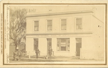
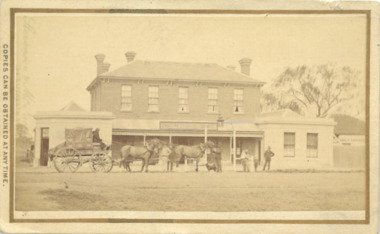
Photograph, Stevenson & McNicoll Photographers, The National Bank of Australasia, Main Street Bacchus Marsh, 1883
... The National Bank of Australasia, Main Street Bacchus Marsh. ...This photo of the National Bank of Australasia dates from 1883. The Bacchus Marsh Branch of the National Bank was established in 1862 and moved into its own premises at 127 Main Street in 1865. The building was designed by Leonard Terry and built by J.F.Taylor Snr. Additions to the building were made in 1869 and a banking chamber, in Roman Villa style, was added in 1904. This two storey bank was built with accommodation for the manager and his family who occupied part of the ground floor as well as upstairs. The bank sold these premises to solicitor Pauline Madden in July 1987 and is her current business premises.Small sepia unframed photograph on card with gold border framing photograph. Housed in the album, 'Photographs of Bacchus Marsh and District in 1883 by Stevenson and McNicoll'. The photo shows an elegant two-storeyed building, with a sign ‘The National Bank of Australasia’ running between the two levels. The ground floor has two doors and two windows, the larger one appearing to have a grille open to the public. The upper floor has four windows and looks to be an apartment. Two men stand at the front of the building, one with a dog. A horse is attached to the hitching rail on the street.On the front: Stevenson & McNicoll. Photo. 108 Elizabeth St. Melbourne. COPIES CAN BE OBTAINED AT ANY TIME. On the back: LIGHT & TRUTH inscribed on a banner surmounted by a representation of the rising sun. Copies of this Portrait can be had at any time by sending the Name and Post Office Money Order or Stamps for the amount of order to STEVENSON & McNICOLL LATE BENSON & STEVENSON, Photographers. 108 Elizabeth Street, MELBOURNE. bacchus marsh vic. history, national bank of australasia bacchus marsh branch, stevenson and mcnicoll 1883 photographs of bacchus marsh and district -
 Greensborough Historical Society
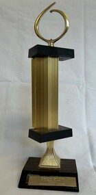
Award - Trophy, Thomastown Golf Club, Thomastown Golf Club. B Grade winner, R. Jones, Bacchus Marsh, 05/12/1982, 1982
... Thomastown Golf Club. B Grade winner, R. Jones, Bacchus ...Golf trophy awarded by the Thomastown Golf Club. Bob Jones was a foundation member of the Club and Secretary for many years.Thomastown Golf Club was a social club formed in 1976. This is part of the Robert (Bob) Jones collection of Club memorabilia.Golf trophy, plastic and timber. "Thomastown Golf Club. B Grade winner, R. Jones, Bacchus Marsh, 05/12/1982." engraved on plaque.thomastown golf club, golf trophies, bob jones, robert jones -
 Bacchus Marsh & District Historical Society
Photograph, Border Inn, Main Street Bacchus Marsh 1883
... Border Inn, Main Street Bacchus Marsh 1883 ...The Border Inn located on the corner of Main Street and Graham Street Bacchus Marsh opened in 1851 making it a very early hotel in Victoria. It was built and owned by John Pilmer. The first licensee was James Watt. The building has been added to and changed many times. It was originally a single storey building. A second storey was added in 1863 by John Pilmer. In 1866 the hotel was purchased by Edward Jones. The Jones family owned and operated the hotel until 1939. Additional second storey sections were added in 1883, 1904 and 1936. For a number of years the Border Inn was a stopping post for coaching services between Melbourne and Ballarat. The first licensee of the hotel James Watt was among the first in Victoria to offer a regular coaching service and his hotel was used for overnight accommodation by coach travellers. At the time this picture was taken coach services were still operating between Bacchus Marsh and other locations. The coach in this picture is possibly one of those coaches.This building has been documented as of state significance by Richard Peterson and Daniel Catrice in their 1995 heritage study for the then Shire of Bacchus Marsh. Their assessment of the heritage significance of the building was: "The Border Inn is of state historical significance as a pioneering pre-gold rush building, on the route to the Ballarat goldfields. It is the representative-embodiment of several historical periods and their way of life. It demonstrates a complex changing sequence of patterns of occupancy and architectural styles. Its development at this location, demonstrates the effect of a social movement, the gold rush, as a transport stopover.It is also historically significant for its association with the first rural public transport in Victoria. Locally, the hotel is significance for its association with the first meeting of municipal government, and also for its social significance as a traditional community, visitor focus and meeting place".Small sepia unframed photograph on card with gold border framing photograph. Housed in the album, 'Photographs of Bacchus Marsh and District in 1883 by Stevenson and McNicoll'. The image shows the Border Inn Hotel at an angle depicting the front of the building facing directly to the camera. It is a two storey brick building, with one-story additions at either end. Five chimneys can be seen extending from the building. The bottom storey has a verandah extending onto the footpath. A covered wagon, probably a coach, with four horses in harness is in front of the building. There are several people in the image. Two people are sitting on the driver’s seat of the wagon. Another man is standing holding the reins of the horses. At his feet is a dog. Behind them are two male adults. One is holding a small child. A young boy stands beside him.On the front: Stevenson & McNicoll. Photo. 108 Elizabeth St. Melbourne. COPIES CAN BE OBTAINED AT ANY TIME. On the back: LIGHT & TRUTH inscribed on a banner surmounted by a representation of the rising sun. Copies of this Portrait can be had at any time by sending the Name and Post Office Money Order or Stamps for the amount of order to STEVENSON & McNICOLL LATE BENSON & STEVENSON, Photographers. 108 Elizabeth Street, MELBOURNE. stevenson and mcnicoll 1883 photographs of bacchus marsh and district, hotels bacchus marsh, border inn hotel bacchus marsh, carriages and coaches, stagecoaches, james watt bacchus marsh, john pilmer bacchus marsh, edward jones family bacchus marsh -
 Bacchus Marsh & District Historical Society
Photograph, Royal Hotel corner of Main and Young Streets Bacchus Marsh 1883
... Royal Hotel corner of Main and Young Streets Bacchus Marsh ...This image is one of a series of photographs taken by Melbourne based photographers Stevenson and McNicoll who visited Bacchus Marsh nearby districts between September and November 1883. The Royal Hotel was built in 1861 and is located on the corner of Main and Young Streets in Bacchus Marsh. The first owner was James Murray and the hotel was first known as the Murray Family Hotel. James Murray died in an accident in 1863 and sometime after this the ownership passed to Richard Manning. From around 1869 it became known as the Royal Hotel. Richard Manning's son Frederick Manning inherited the hotel in 1896. The Manning family owned the hotel until sometime after 1945. In more recent decades it has been owned and operated by a number of different people. The hotel continues to operate as of 2024. This image shows the building in its original structure. In 1888, five years after this image was taken, a second storey was added to the section on Young Street. In this image this section is the single storey section of wall without windows to the right of the picture. Small sepia 'carte de viste' style unframed photograph on card with gold border framing photograph. Housed in the album, 'Photographs of Bacchus Marsh and District in 1883 by Stevenson and McNicoll'. The image shows the Royal Hotel seen from the intersection of Main and Young Streets. The diagonal view shows both the Main Street and Young Street sides of the building. It is a two storey brick building with a single storey brick extension on the Young Street frontage. Standing at the corner of the building is a woman and five girls. A deep gutter runs along the Main Street, with a pedestrian crossing ramp. Over this crossing point, there is a large metal frame bearing an ornate lantern. Next to it is a water trough for horses. Several hitching posts can be seen along the footpaths.Printed On the front: Stevenson & McNicoll. Photo. 108 Elizabeth St. Melbourne. COPIES CAN BE OBTAINED AT ANY TIME. On the back: LIGHT & TRUTH inscribed on a banner surmounted by a representation of the rising sun. Copies of this Portrait can be had at any time by sending the Name and Post Office Money Order or Stamps for the amount of order to STEVENSON & McNICOLL LATE BENSON & STEVENSON, Photographers. 108 Elizabeth Street, MELBOURNE. stevenson and mcnicoll 1883 photographs of bacchus marsh and district, hotels bacchus marsh, royal hotel bacchus marsh, manning family bacchus marsh, murray family hotel bacchus marsh -
 Greensborough Historical Society
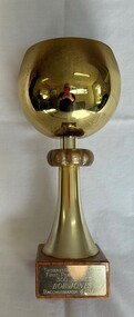
Award - Trophy, Thomastown Golf Club, Thomastown Golf Club. First player to reach 300 games: Bob Jones, Bacchus Marsh, 04/11/1990, 1990
... Jones, Bacchus Marsh, 04/11/1990. ...Golf trophy awarded by the Thomastown Golf Club. Bob Jones was a foundation member of the Club and Secretary for many years.Thomastown Golf Club was a social club formed in 1976. This is part of the Robert (Bob) Jones collection of Club memorabilia.Golf trophy, large metal cup on timber base."Thomastown Golf Club. First player to reach 300 games: Bob Jones, Bacchus Marsh, 04/11/1990. " engraved on plaque.thomastown golf club, golf trophies, bob jones -
 Bacchus Marsh & District Historical Society
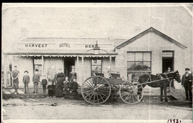
Photograph, Harvest Home Hotel Main Street Bacchus Marsh c.1880s-1890s
... Harvest Home Hotel Main Street Bacchus Marsh c.1880s-1890s ...The Harvest Home Hotel was licensed as a beer shop in 1866. Patrick Vallence was the licensee. On his death in 1874 his widow Mrs M. A. Vallence obtained the license. The date that this image was created has not been identified. Around 1883 George Marshall was leasing the hotel. The people in this image are could be members of the Marshall family and some of the staff who worked in the hotel at this time. Following a decrease in the population of Bacchus Marsh by 1911 the hotel had lost its licence. The Vallence family still owned the building after the loss of the hotel license in 1911and it was used for some years after this as a private residence by some members of the Vallence family. Small black and white photograph. The image depicts the Harvest Home Hotel situated in Main Street Bacchus Marsh. The name of the hotel can be seen above the verandah roof. The building appears to be of stone with decorative stonework corners. A verandah is inset to the left of a gabled front section which has its own door and window. A deep gutter runs along the front of the hotel, with a slab acting as a bridge to the road. Standing in front of the building facing the camera is a group of adults and children, men and women and boys and girls. A four seated buggy drawn by a single horse is also present in the image. The lantern erected above the horse trough can be seen.hotels bacchus marsh, vallence family bacchus marsh, marshall family bacchus marsh, harvest home hotel bacchus marsh -
 Bacchus Marsh & District Historical Society
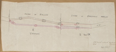
Map, Road plan deviation near Glenmore
... Shire of Bacchus Marsh ...This plan shows a proposed deviation in the road near Glenmore. This is likely to have been the Bacchus Marsh to Ballan road. The precise date of the plan has not been established. Proposed deviations to the road near Glenmore appear in reports in the Bacchus Marsh Express newspaper through many decades, especially in the 1870s and 1880s. Glenmore is located 19 kilometers west of Bacchus Marsh.A single page paper map showing a plan for a road deviation near Glenmore Station. Scale 5 chains to 1 inch. Date of production unknown. Circa 1860s-1890s. The map is pasted into a bound volume containing 76 maps or plans in total. High resolution digital image stored on BMDHS computer network. Old road colored Yellow, New road colored Pinkroad plans, road construction, glenmore victoria maps -
 Bacchus Marsh & District Historical Society
Map, Bullengarook Parish, County of Bourke
... Shire of Bacchus Marsh ...An undated parish plan map for the parish of Bullegarook. This parish area is close to the Bacchus Marsh district and borders some of the areas contained within the former Bacchus Marsh Shire and present day Moorabool Shire.A single page paper map showing the parish plan map for Bullengarook. This parish area contains the locality of Bullengarook and parts of the Wombat State Forest and is close to the town of Gisborne. A cadastral map showing land ownership. The map is not dated but a very similar map held by the State Library of Victoria is estimated to date from about 1927. The map is pasted into a bound volume containing 76 maps or plans in total. High resolution digital image stored on BMDHS computer network. bullengarook parish maps -
 Ballarat Heritage Services
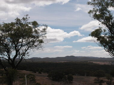
Photograph - Photograph - Colour, Coimodai near Bacchus Marsh, 2007, 04/03/2007
... Coimodai near Bacchus Marsh, 2007 ...Coimodai is in the vicinity of Bacchus Marsh, VictoriaA number of photos taken to create a 360 degree view of Coimadaicoimodai, farmland, landscape -
 Bacchus Marsh & District Historical Society
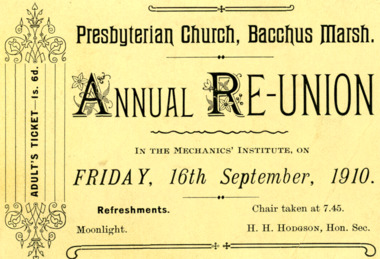
Ephemera - Ticket, Presbyterian Church Bacchus Marsh Annual Reunion 1910
... Presbyterian Church Bacchus Marsh Annual Reunion 1910 ...This is a printed invitation for the Annual Reunion for the Presbyterian Church Bacchus Marsh. The Presbyterian church organised many social events in Bacchus Marsh. This particular event was promoted in the Bacchus Marsh Express in this way, "The Bacchus Marsh Presbyterian re union takes place on Friday, 16th inst, when a good programme is promised. Mr. C. Thompson, S.M., has been successful in securing a number of items from talented friends in Melbourne. Miss Alice Grant, and Miss Belle Morton, will be amongst the local performers. A full programme will be given in next week's issue."Printed ticket on card. Rectangular shape.saint andrews presbyterian church bacchus marsh, churches bacchus marsh -
![Manuscript, As We Go to Press. [Recollections of the Bacchus Marsh Express Newspaper and Printing Company]](/media/collectors/5e461d8021ea67224c82f2a1/items/6822ccb5aa2a8060869222f7/item-media/6822cd36aa2a806086923fda/item-fit-380x285.jpg) Bacchus Marsh & District Historical Society
Bacchus Marsh & District Historical SocietyManuscript, As We Go to Press. [Recollections of the Bacchus Marsh Express Newspaper and Printing Company]
... As We Go to Press. [Recollections of the Bacchus Marsh ...Allan Arnup was born in Bacchus Marsh in 1913. In 1929 he began work at the Bacchus Marsh Express newspaper as an apprentice printer. Over several decades he worked there as a printer, foreman and eventually as a manager. The Express newspaper, founded in 1866, was printed in Bacchus Marsh for over 100 years. The Express also provided a general printing service for the community in addition to printing copies of the Express newspaper. This unpublished manuscript was written around 1990 and looks back on Arnup's long career as a printer and manager with the Bacchus Marsh Express newspaper and printing business.Manuscript. Typescript. Spiral bound. 29 pages. Photocopy of an original typescript. BMDHS Location: AR/SU5/Magazine Box 1allan arnup 1913-1997, bacchus marsh express newspaper, printers, printing industry, bacchus marsh express printing business, newspapers bacchus marsh, crisp family bacchus marsh -
 Bacchus Marsh & District Historical Society
Photograph, Baptist Chapel Lerderderg Street Bacchus Marsh 1883
... Baptist Chapel Lerderderg Street Bacchus Marsh 1883 ...The Baptist Chapel was first opened in March 1868 in Lerderderg Street, Bacchus Marsh, next to State School No. 28. The plans were prepared by James G. Pippett and the building was constructed by bricklayer J.F.Taylor and carpenter W. Nelson. When fire threatened its destruction in 1871, the townspeople assisted in saving the building by tearing off the roof and removing windows and flooring. Subsequently it was found that a solid silver Communion Service was missing as well as the contents of the Poor Box. The Chapel was renovated and used until 1898 when the building was moved to Main Street, next to the Post Office. Two rooms were added at the front when the building was rebuilt. It was demolished in 1985.Small sepia unframed photograph on card with gold border framing photograph. Housed in the Jeremeas Family Album, which contains photographs of Bacchus Marsh and District in 1883 by Stevenson and McNicoll. The photograph is of a substantial brick building with a shingle roof. The gable above the front entrance and the side of the building under the guttering are ornamented with rows of bricks laid horizontally. A round window sits in the centre of the gable. The central door and the front and side sash windows are topped by semi-circular brick arches. The ornamentation is continued with contrasting bricks down the corners of the building. An ornamental iron fence runs along the front of the building. A large fir tree stands in the grounds. On the front: Stevenson & McNicoll. Photo. 108 Elizabeth St. Melbourne. COPIES CAN BE OBTAINED AT ANY TIME. On the back: LIGHT & TRUTH inscribed on a banner surmounted by a representation of the rising sun. Copies of this Portrait can be had at any time by sending the Name and Post Office Money Order or Stamps for the amount of order to STEVENSON & McNICOLL LATE BENSON & STEVENSON, Photographers. 108 Elizabeth Street, MELBOURNE churches bacchus marsh, baptist chapel bacchus marsh -
 Bacchus Marsh & District Historical Society
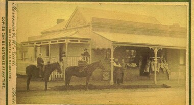
Photograph, Thomas Heath's Saddlery Main Street Bacchus Marsh 1883 Image 2
... Thomas Heath's Saddlery Main Street Bacchus Marsh 1883 ...Thomas Heath built this shop for his saddlery business around 1875. In 1926 after 58 years operating his saddlery in Bacchus Marsh he retired and the assets of his business were sold in a clearing sale. The building was located close to the current day location of 192 Main Street and has been demolished. Apart from his services in saddlery his premises was known to be a gathering place for much discussion. Heath was known to openly express his political opinions and his saddlery premises was known by many in the community as the 'Parliament'.Small sepia unframed photograph on card with gold border framing photograph. Housed in the album, 'Photographs of Bacchus Marsh and District in 1883 by Stevenson and McNicoll'. The photo is of a double-fronted weatherboard building with a shingle roof. The front gabled section stands directly on street level and is flanked by a picket fence. The door and overhead window and the side window with arched panels may indicate that this was the shop section, with a dwelling to the rear. The recessed side section of the building with a twelve-sectioned window, chimney and a back extension was probably the dwelling used by the family. In the doorway stands the saddler, probably Thomas Heath. To his left is a woman, possibly Mrs Heath, and a much younger woman, possibly a daughter of the Heaths. In front of the two women is a small dog. A hitching rail runs along the front of the workshop. Indicating the type of business Mr Heath ran. On the front: Stevenson & McNicoll. Photo. 108 Elizabeth St. Melbourne. COPIES CAN BE OBTAINED AT ANY TIME. On the back: LIGHT & TRUTH inscribed on a banner surmounted by a representation of the rising sun. Copies of this Portrait can be had at any time by sending the Name and Post Office Money Order or Stamps for the amount of order to STEVENSON & McNICOLL LATE BENSON & STEVENSON, Photographers. 108 Elizabeth Street, MELBOURNE. saddleries, saddlers, thomas heath 1842-1930 saddler, heath family bacchus marsh, stevenson and mcnicoll 1883 photographs of bacchus marsh and district -
 Bacchus Marsh & District Historical Society
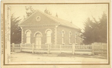
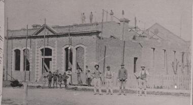
Photograph, Mechanics Institute and Hall Main Street, Bacchus Marsh 1883
... Mechanics Institute and Hall Main Street, Bacchus Marsh ...A Mechanics Institute in Bacchus Marsh dates from sometime in the 1850s. The first Mechanics Institute Hall was erected in 1858 in Young Street.(Victorian Collections no.659.) In 1883 a new and larger Mechanics Institute Hall was built in Main Street. The new hall cost 2,000 pounds to construct. It was opened by Sir William Clarke on 21 November 1883. The Mechanics Institute Library and rooms at the front of the hall were removed when the building was renovated in 1971. The building still stands and is used as a public hall.Small black and white 'carte de viste' style unframed photograph on card with gold border framing photograph. Housed in the Jeremeas Family Album which contains photographs of Bacchus Marsh and District in 1883 by the photographers Stevenson and McNicoll. The photo is of a substantial brick building under construction. Scaffolding support poles line the front and also can be seen on the top and back of the building. On the rooftop stand three workmen, with a further seven men standing at the front. Three men lean or stand casually at the front in casual poses. Four men stand in a line in another group on the roadway, perhaps indicating that they are master craftsmen. One of these men holds a tool of his trade, resembling a bricklayer’s mortar board. Six boys can be seen, four in a rather jaunty pose. In an indication of its public significance, the four front windows and door are arched and have decorative stone work in the side panels. A picket fence marks the boundary of the adjacent block.Printed On the front: Stevenson & McNicoll. Photo. 108 Elizabeth St. Melbourne. COPIES CAN BE OBTAINED AT ANY TIME. On the back: LIGHT & TRUTH inscribed on a banner surmounted by a representation of the rising sun. Copies of this Portrait can be had at any time by sending the Name and Post Office Money Order or Stamps for the amount of order to STEVENSON & McNICOLL LATE BENSON & STEVENSON, Photographers. 108 Elizabeth Street, MELBOURNE. stevenson and mcnicoll 1883 photographs of bacchus marsh and district, mechanics institutes, halls, bacchus marsh mechanics institute -
 Bacchus Marsh & District Historical Society
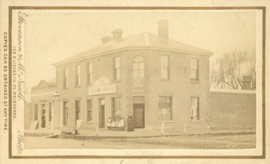
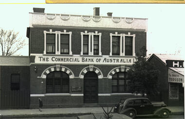
Photograph, Commercial Bank of Australia Main Street Bacchus Marsh
... Commercial Bank of Australia Main Street Bacchus Marsh ...The Commercial Bank of Australia building was constructed by J. F. Taylor in 1907 and shortly after commenced operations as a bank. The building was in use as a CBA bank until 1976 when it was demolished and a new building erected. The CBA continued its operations at this location; subsequently, various banks, such as the Bank of Melbourne and Westpac operated there. Part of the new building is now in use as a newsagency. The original architectural plans for this building designed by Walter Butler are held by the State Library of Victoria and can be viewed online through the Library's website: Citation: Butler, W. R., & Taylor, J. F. (1906). Design for banking premises at Bacchus Marsh for the Commercial Bank of Australia Ltd. URL: http://handle.slv.vic.gov.au/10381/473561 Black and white photographic print. Photograph of the Commercial Bank 138 Main Street Bacchus Marsh. On the left is a smaller brick building adjoining the bank. On the right there is a partial shot of a shop called The House of Hodgson. The bank building itself is shown as a substantial two-story brick building, the top storey appearing to be a dwelling with three ornamented windows furnished with curtains and blinds. The storeys are divided by a white panel bearing the words "The Commercial Bank of Australia Ltd". The lower storey has a central entrance with a panelled door. The door is flanked by two windows with reinforced lattices. The windows and door are surmounted by decorative arches reminiscent of Spanish Moorish architecture. A car (possibly a 1937 Dodge) is parked on the street. A lone girl stands on the footpath waving at the photographer.On the back: In pencil: 1937 Dodge?shops bacchus marsh vic., main street bacchus marsh vic., banks bacchus marsh vic., commercial bank of australia bacchus marsh -
 Bacchus Marsh & District Historical Society
Photograph, Thomas Heath's Saddlery Main Street Bacchus Marsh 1883 Image 1
... Thomas Heath's Saddlery Main Street Bacchus Marsh 1883 ...Thomas Heath built this shop for his saddlery business around 1875. In 1926 after 58 years operating his saddlery in Bacchus Marsh he retired and the assets of his business were sold in a clearing sale. The building was located close to the current day location of 192 Main Street and has been demolished. Apart from his services in saddlery his premises was known to be a gathering place for much discussion. Heath was known to openly express his political opinions and his saddlery premises was known by many in the community as the 'Parliament'.Small sepia unframed photograph on card with gold border framing photograph. Housed in the album, 'Photographs of Bacchus Marsh and District in 1883 by Stevenson and McNicoll'. The photo is of a double-fronted weatherboard building with a shingle roof. The front gabled section stands directly on street level and is flanked by a picket fence. The door and overhead window and the side window with arched panels may indicate that this was the shop section, with a dwelling to the rear. Items which may be for sale can be seen hanging in the windows. The recessed side section of the building with a twelve-sectioned window, chimney and a back extension was probably the dwelling used by the family. On the footpath stands the saddler with three children, two boys and an older girl, probably Mr Thomas Heath and three of his five children. A hitching rail runs along the front of the workshop. Indicating the type of business Mr Heath ran, are a saddle placed over the rail and two horse collars and reins hanging either side of the workshop door. On the front: Stevenson & McNicoll. Photo. 108 Elizabeth St. Melbourne. COPIES CAN BE OBTAINED AT ANY TIME. On the back: LIGHT & TRUTH inscribed on a banner surmounted by a representation of the rising sun. Copies of this Portrait can be had at any time by sending the Name and Post Office Money Order or Stamps for the amount of order to STEVENSON & McNICOLL LATE BENSON & STEVENSON, Photographers. 108 Elizabeth Street, MELBOURNE. saddleries, saddlers, thomas heath 1842-1930 saddler -
 Bacchus Marsh & District Historical Society
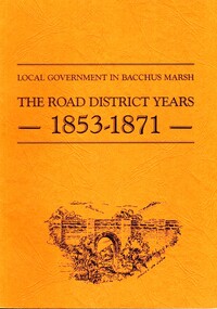
Book, John Lloyd, The Road District Years, 1853-1871: Local Government in Bacchus Marsh
... Bacchus Marsh ...This work describes the early evolution and history of local government in the Bacchus Marsh area. Local government bodies in Victoria and in other places had their origins in committees and local boards which were established to regulate over pressing local issues, raise revenue, and expend it in a limited range of social and economic ways. The early areas of responsibility were dominated by the need for local roads and this book primarily looks at this period of local government history in the Bacchus Marsh area. Overtime the range of areas local government bodies took responsibility for expanded and this work begins to trace this transformation in its earliest stages. It is a fascinating and detailed account of the early history of local government in Bacchus Marsh containing many amusing anecdotes among the wealth of administrative historical data. The author who was at one time an employee of the Shire of Bacchus Marsh has drawn directly from the early local records such as minutes of meetings, records of expenditure, newspaper reports and notices in the Victoria Government Gazette.Soft cover foolscap size book. 128 pages with b & w illustrations, maps and plans. No publisher is indicated in the work but it is likely to have been privately published by the author John Lloyd. Year and place of publication is 1986, Bacchus Marsh, Victoria.non-fictionThis work describes the early evolution and history of local government in the Bacchus Marsh area. Local government bodies in Victoria and in other places had their origins in committees and local boards which were established to regulate over pressing local issues, raise revenue, and expend it in a limited range of social and economic ways. The early areas of responsibility were dominated by the need for local roads and this book primarily looks at this period of local government history in the Bacchus Marsh area. Overtime the range of areas local government bodies took responsibility for expanded and this work begins to trace this transformation in its earliest stages. It is a fascinating and detailed account of the early history of local government in Bacchus Marsh containing many amusing anecdotes among the wealth of administrative historical data. The author who was at one time an employee of the Shire of Bacchus Marsh has drawn directly from the early local records such as minutes of meetings, records of expenditure, newspaper reports and notices in the Victoria Government Gazette.bacchus marsh shire council, local government bacchus marsh history -
![Map, [Plan for road to give J. Allan access to permanent water at Coimadai] circa 1870s](/media/collectors/5e461d8021ea67224c82f2a1/items/67735190d671e67dd573a84c/item-media/6773533dd671e67dd573cd90/item-fit-380x285.jpg) Bacchus Marsh & District Historical Society
Bacchus Marsh & District Historical SocietyMap, [Plan for road to give J. Allan access to permanent water at Coimadai] circa 1870s
... Shire of Bacchus Marsh ...The date of this map or plan is uncertain but it appears to be from the early to mid 1870s. One of the landholders identified on the plan, James Allan of Coimadai died suddenly on the 9th July, 1874 (see Bacchus Marsh Express, 11 July, 1874, page. 3). There are mentions of an Allans Road at Coimadai in the Bacchus Marsh Express between 1887 and 1942.Single page map showing an excision of land belonging to Charles Ross which was selected to construct a road to give another landholder, J. Allan access to permanent water. Scale 1 chain to 1 inch. Part of a set of maps which are pasted into a bound volume containing 76 maps or plans in total. High resolution digital image stored on BMDHS computer network. Plan showing Excisions from Ross's selection and 1 chain road thro' the said selection in Coimadai to give J. Allan access to permanent water. Alistair ?? Shire Eng? 6?/5/7?coimadai victoria maps, coimadai roads and streets -
 Bacchus Marsh & District Historical Society
Photograph, Edward's Butchers Shop Main Street Bacchus Marsh 1883
... Edward's Butchers Shop Main Street Bacchus Marsh 1883 ...This Butcher’s shop was opened by J. Edwards. It adjoined G. Dickie’s bakery in Main Sreet. Later occupants of the premises included Beardmore, Clark, Bence and Ramsey.Small sepia 'carte de viste' style unframed photograph on card with gold border framing photograph. Housed in the album, 'Photographs of Bacchus Marsh and District in 1883 by Stevenson and McNicoll'. The image depicts a butcher’s premises in Main Street Bacchus Marsh. The butcher and another man stand on the verandah in front of the shop. Behind them meat for sale is seen hanging from a rack. Two other people stand under the verandah at the front of the dwelling which runs along the side of the shop. In the street are two other people, one of whom holds a delivery basket, mounted on horses.Printed On the front: Stevenson & McNicoll. Photo. 108 Elizabeth St. Melbourne. COPIES CAN BE OBTAINED AT ANY TIME. On the back: LIGHT & TRUTH inscribed on a banner surmounted by a representation of the rising sun. Copies of this Portrait can be had at any time by sending the Name and Post Office Money Order or Stamps for the amount of order to STEVENSON & McNICOLL LATE BENSON & STEVENSON, Photographers. 108 Elizabeth Street, MELBOURNE.stevenson and mcnicoll 1883 photographs of bacchus marsh and district, butchers, butcher shops -
 Bacchus Marsh & District Historical Society
Map, Plan of Survey of Part of Crown Allotment 9, Parish of Korkuperrimul, 1890
... Shire of Bacchus Marsh ...This map documents a transfer of an allotment of land in Clarke Street Bacchus Marsh in 1890. Clarke Street is located on the eastern side of Bacchus Marsh not far from Main Street and Crook Street. It is now known as Candeloro Street. The map indicates J. Booth as the owner of the land and H. Simpson as the occupier. Next to this allotment is a an allotment of land owned by J. Elmore,Single page map showing Crown allotment 9, Parish of Korkuperrimul, County of Bourke. Scale 100 feet to inch. Part of a set of maps which are pasted into a bound volume containing 76 maps or plans in total. High resolution digital image stored on BMDHS computer network. At bottom of map: I hereby certify that I have made this survey expressly for the purpose of an application under the Transfer of Land Statute that this plan is correct. Barry B???, Lic. Surveyor, 16.10.90bacchus marsh victoria maps, clarke street bacchus marsh maps -
 Bacchus Marsh & District Historical Society
Map, Maddingley Township, Parish of Parwan, County of Grant, 1856
... Shire of Bacchus Marsh ...Maddingley is a locality or township within the broader township area of Bacchus Marsh. This map is dated 1856 but is based on an earlier survey in 1843. The main area of Maddingley shown on this map is an area bounded by Bacchus Street, Moore Street, Griffith Street and Franklin Street. Other streets visible are Inglis Street, Labilliere Street, McCrae Street. The area to the east of Franklin Street is not sub-divided and is described as an 'alluvial flat. A single page paper map showing land allotments, streets, and natural watercourses in the township of Maddingley. The map is pasted into a bound volume containing 76 maps or plans in total. Two inscriptions: 1. A.J. Skene Surveyor, 1843. ; 2. Surveyor-General's Office Melbourne, Sept 6, 1856. (Lithographed by R. Meikle)bacchus marsh victoria maps, maddingley victoria maps, land use, maddingley victoria history -
 Bacchus Marsh & District Historical Society
Map, Gorrockburkchap Parish Map, County of Grant c.1906
... Shire of Bacchus Marsh ...The parish of Gorrockburkchap (sometimes spelled Gorrockburkghap) lies to the west and south west of the township of Bacchus Marsh. The locality of Rowsley is situated within this parish area.A single page paper map showing the parish plan for Gorrockburkchap in the County of Grant. A cadastral map showing parish boundaries and land ownership The map is pasted into a bound volume containing 76 maps or plans in total. High resolution digital image stored on BMDHS computer network. gorrockburkchap parish maps, rowsley victoria maps, bacchus marsh region parish plans -
 Bacchus Marsh & District Historical Society
Map, Gorrockburkchap Parish Map, County of Grant c.1915
... Shire of Bacchus Marsh ...The parish of Gorrockburkchap (sometimes spelled Gorrockburkghap) lies to the west and south west of the township of Bacchus Marsh. The locality of Rowsley is situated within this parish area.A single page paper map showing the parish plan for Gorrockburkchap in the County of Grant. The map is pasted into a bound volume containing 76 maps or plans in total. High resolution digital image stored on BMDHS computer network. gorrockburkchap parish maps, rowsley victoria maps -
 Bacchus Marsh & District Historical Society
Map, Gorrockburkchap Parish Map, County of Grant
... Shire of Bacchus Marsh ...The parish of Gorrockburkchap (sometimes spelled Gorrockburkghap) lies to the west and south west of the township of Bacchus Marsh. The locality of Rowsley is situated within this parish area.A single page paper map showing the parish plan for Gorrockburkchap in the County of Grant. The map is pasted into a bound volume containing 76 maps or plans in total. High resolution digital image stored on BMDHS computer network. gorrockburkchap parish maps, rowsley victoria maps -
 Bacchus Marsh & District Historical Society
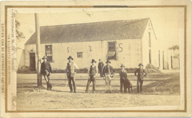
Photograph, Woolpack Stables Bacchus Marsh 1883
... Woolpack Stables Bacchus Marsh 1883 ...This image is one of a series of photographs taken by Melbourne based photographers Stevenson and McNicoll who visited Bacchus Marsh and its nearby districts between September and November 1883. James Elijah Crook settled in Bacchus Marsh in 1841 and soon after held a licence for a lodging house on the Portland Road. In about 1845, he built the first Woolpack Inn, a slab building of eight rooms. This was replaced in 1850 with a “stately country villa” of brick and stone. The stables were also built in 1850 to accommodate twenty horses. In 1851, Crook established a coach service to the goldfields. After being in use as a Court of Petty Sessions, the Woolpack Inn lost its licence and closed in 1862. After this date, Crook took an interest in horse-breeding and continued to use the stables for his horses. His most notable success was with his horse, Saladin, which won the Australia Cup in 1872, after two exciting dead-heats with The Flying Dutchman. James Elijah Crook died in 1889. The Woolpack Inn and Stables were sold and then used as a hay and corn store. In 1910 the site was leased for use as an abattoir. The Woolpack Inn was demolished in 1931. The site is still in use as an abattoir. Little remains of the original stables.Small sepia 'carte de viste' style unframed photograph on card with gold border framing photograph. Housed in the Jeremeas Family Album which contains photographs of Bacchus Marsh and District in 1883 by the photographers Stevenson and McNicoll. The photo is of a gable-roofed commercial stables with shingled roofing, and white-washed render to the walls, standing in a large cleared yard. There is a skillion extension to the south-west corner. On the front (northern) wall can be seen a door and three windows, two large and one small paned window in the centre. The eastern window is paned, while the western window has louvres and a pull-out blind. Three S shaped stays can be seen on the northern wall. Along the western wall are two more windows and doors. A mound of hay lies at the north-western corner. Standing at the front of the stables is a group of five men and two boys, one holding a large dog. Four of the men are dressed in workman’s clothing and some are holding tools of their trade. The man at the back is wearing more formal clothes and has distanced himself from the workmen. The pole against which one of the workmen is leaning appears to have damage along one side. This pole may have been used as a hitching post as there is a footrest installed lower down to make mounting easier. Printed On the front: Stevenson & McNicoll. Photo. 108 Elizabeth St. Melbourne. COPIES CAN BE OBTAINED AT ANY TIME. On the back: LIGHT & TRUTH inscribed on a banner surmounted by a representation of the rising sun. Copies of this Portrait can be had at any time by sending the Name and Post Office Money Order or Stamps for the amount of order to STEVENSON & McNICOLL LATE BENSON & STEVENSON, Photographers. 108 Elizabeth Street, MELBOURNE. stevenson and mcnicoll 1883 photographs of bacchus marsh and district -
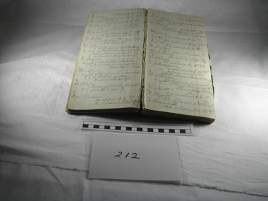 Blacksmith's Cottage and Forge
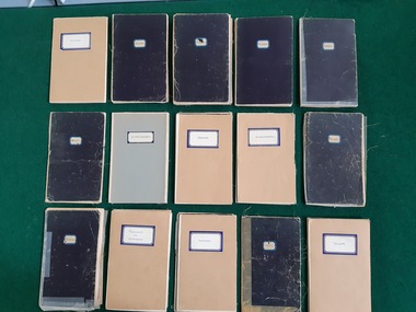
Book, Day, Day Book, 20 January 1920 to 27 April 1921
... Bacchus Marsh, Australia ...This book contains information relating to daily work conducted by Charles Edwards, Blacksmith, during period 20th January 1920 to 27 April 1921. It lists customer names, types of work done and costs involved. The written X indicates whether work was paid in full.This books contains historical information relating to peoples names and industries in the Bacchus Marsh district and the work performed for them by the blacksmith during the period mentioned. Most of work relates to shoeing horses, repairs to horse drawn vehicles, repairs to farm machinery/tools and some work on cars.Cardboard covers - green marbled design with black spine. Account type book with red ruled columns. Hand written names, jobs, charges and dates.On the inner cover - Mrs C Edwards, Main Street, Bacchus Marshbook, blacksmith, day, customers, clients, charles edwards