Showing 302 items matching "brick and stone"
-
 Ballarat Heritage Services
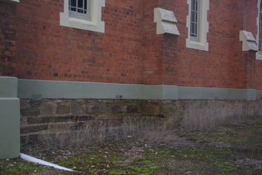
Photograph - Photograph - Colour, Clare Gervasoni, Sandstone foundations at St Laurence O'Toole Catholic Church, Sandon, 2017, 16/07/2017
St Laurence O'Toole church and cemetery is located in a rural setting at 801/821 Creswick-Newstead Rd, Sandon. Originally a small wooden school (22’x14’) was erected in Sandon by Father Patrick Smyth (who was involved in the Eureka Stockade movement) in 1859. It was also used for Mass and became known as a chapel. In June 1882 tenders were called for the construction of a brick Church by the Castlemaine architect, T.F. Kibble, and it was built at a cost of 1000 pounds. The church was blessed by Archbishop Goold on 06 May 1883 and dedicated to St Laurence O'Toole. The brick building demonstrates original design qualities of a Victorian Rudimentary Gothic style, including the steeply pitched, parapet gable roof form, together with a central steeply pitched, gabled porch that projects slightly from the main gable end. Other intact qualities include the exposed brick wall construction, lapped galvanised corrugated iron roof cladding, minor gabled porch at the rear, small ventilation dormers nearby the roof ridgeline, series of stone steps that lead to the central porch with its double pointed door opening and vertical boarded doors, simple rose window in the main gable end, pointed windows, brick buttresses with double lower copings, and the light masonry detailing (the banding marking the floor level within, buttress copings, window and door surrounds and quoins, and the drip moulds).(Shire of Mount Alexander: Heritage Study of the former Shire of Newstead, 2000) The visually connected cemetery demonstrates important visual qualities formed by the regular rows of graves and cemetery architecture, and the grassed and treed rural landscape. It is a rare and substantially intact example of a Victorian Catholic Church with a cemetery in its churchyard. Many headstones and cemetery architecture, date from the 19th century and represent some fine examples of masonry craftsmanship. Some refurbisments occurred during the 1940s and in 2002 a major restoration project was undertaken from roof to footings, by a dedicated band of volunteers and trades people. Work was completed mid 2003 and in November 2003 St Laurence’s was re-dedicated with the celebration of Mass and a picnic tea. Details of the exterior of St Laurence O'Toole Catholic Church, Sandon in Central Victoria.sandon, sandon cemetery, st laurence o'toole catholic church, sandon, sandstone, foundations -
 Ballarat Heritage Services
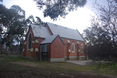
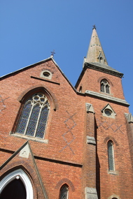
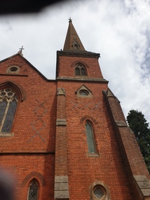
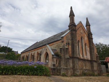
Photograph - Photograph - Colour, Clare Gervasoni, St Laurence O'Toole Catholic Church, Sandon, 2017, 16/07/2017
St Laurence O'Toole church and cemetery is located in a rural setting at 801/821 Creswick-Newstead Rd, Sandon. Originally a small wooden school (22’x14’) was erected in Sandon by Father Patrick Smyth (who was involved in the Eureka Stockade movement) in 1859. It was also used for Mass and became known as a chapel. In June 1882 tenders were called for the construction of a brick Church by the Castlemaine architect, T.F. Kibble, and it was built at a cost of 1000 pounds. The church was blessed by Archbishop Goold on 06 May 1883 and dedicated to St Laurence O'Toole. The brick building demonstrates original design qualities of a Victorian Rudimentary Gothic style, including the steeply pitched, parapet gable roof form, together with a central steeply pitched, gabled porch that projects slightly from the main gable end. Other intact qualities include the exposed brick wall construction, lapped galvanised corrugated iron roof cladding, minor gabled porch at the rear, small ventilation dormers nearby the roof ridgeline, series of stone steps that lead to the central porch with its double pointed door opening and vertical boarded doors, simple rose window in the main gable end, pointed windows, brick buttresses with double lower copings, and the light masonry detailing (the banding marking the floor level within, buttress copings, window and door surrounds and quoins, and the drip moulds).(Shire of Mount Alexander: Heritage Study of the former Shire of Newstead, 2000) The visually connected cemetery demonstrates important visual qualities formed by the regular rows of graves and cemetery architecture, and the grassed and treed rural landscape. It is a rare and substantially intact example of a Victorian Catholic Church with a cemetery in its churchyard. Many headstones and cemetery architecture, date from the 19th century and represent some fine examples of masonry craftsmanship. Some refurbisments occurred during the 1940s and in 2002 a major restoration project was undertaken from roof to footings, by a dedicated band of volunteers and trades people. Work was completed mid 2003 and in November 2003 St Laurence’s was re-dedicated with the celebration of Mass and a picnic tea. Brick church at Sandon, Victoriasandon, sandon cemetery, st laurence o'toole catholic church, sandon -
 Ballarat Heritage Services
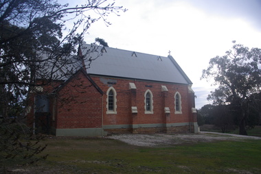
Photograph, Clare Gervasoni, St Laurence O'Toole Catholic Church, Sandon, 2017, 16/07/2017
St Laurence O'Toole church and cemetery is located in a rural setting at 801/821 Creswick-Newstead Rd, Sandon. Originally a small wooden school (22’x14’) was erected in Sandon by Father Patrick Smyth (who was involved in the Eureka Stockade movement) in 1859. It was also used for Mass and became known as a chapel. In June 1882 tenders were called for the construction of a brick Church by the Castlemaine architect, T.F. Kibble, and it was built at a cost of 1000 pounds. The church was blessed by Archbishop Goold on 06 May 1883 and dedicated to St Laurence O'Toole. The brick building demonstrates original design qualities of a Victorian Rudimentary Gothic style, including the steeply pitched, parapet gable roof form, together with a central steeply pitched, gabled porch that projects slightly from the main gable end. Other intact qualities include the exposed brick wall construction, lapped galvanised corrugated iron roof cladding, minor gabled porch at the rear, small ventilation dormers nearby the roof ridgeline, series of stone steps that lead to the central porch with its double pointed door opening and vertical boarded doors, simple rose window in the main gable end, pointed windows, brick buttresses with double lower copings, and the light masonry detailing (the banding marking the floor level within, buttress copings, window and door surrounds and quoins, and the drip moulds).(Shire of Mount Alexander: Heritage Study of the former Shire of Newstead, 2000) The visually connected cemetery demonstrates important visual qualities formed by the regular rows of graves and cemetery architecture, and the grassed and treed rural landscape. It is a rare and substantially intact example of a Victorian Catholic Church with a cemetery in its churchyard. Many headstones and cemetery architecture, date from the 19th century and represent some fine examples of masonry craftsmanship. Some refurbisments occurred during the 1940s and in 2002 a major restoration project was undertaken from roof to footings, by a dedicated band of volunteers and trades people. Work was completed mid 2003 and in November 2003 St Laurence’s was re-dedicated with the celebration of Mass and a picnic tea. Colour photograph of a red brick church in Sandon. sandon, sandon cemetery, st laurence o'toole catholic church, sandon -
 Ballarat Heritage Services
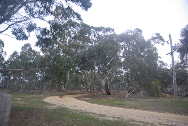
Photograph - Photograph - Colour, Clare Gervasoni, Treed road behind St Laurence O'Toole Catholic Church, Sandon, 2017, 16/07/2017
St Laurence O'Toole church and cemetery is located in a rural setting at 801/821 Creswick-Newstead Rd, Sandon. Originally a small wooden school (22’x14’) was erected in Sandon by Father Patrick Smyth (who was involved in the Eureka Stockade movement) in 1859. It was also used for Mass and became known as a chapel. In June 1882 tenders were called for the construction of a brick Church by the Castlemaine architect, T.F. Kibble, and it was built at a cost of 1000 pounds. The church was blessed by Archbishop Goold on 06 May 1883 and dedicated to St Laurence O'Toole. The brick building demonstrates original design qualities of a Victorian Rudimentary Gothic style, including the steeply pitched, parapet gable roof form, together with a central steeply pitched, gabled porch that projects slightly from the main gable end. Other intact qualities include the exposed brick wall construction, lapped galvanised corrugated iron roof cladding, minor gabled porch at the rear, small ventilation dormers nearby the roof ridgeline, series of stone steps that lead to the central porch with its double pointed door opening and vertical boarded doors, simple rose window in the main gable end, pointed windows, brick buttresses with double lower copings, and the light masonry detailing (the banding marking the floor level within, buttress copings, window and door surrounds and quoins, and the drip moulds).(Shire of Mount Alexander: Heritage Study of the former Shire of Newstead, 2000) The visually connected cemetery demonstrates important visual qualities formed by the regular rows of graves and cemetery architecture, and the grassed and treed rural landscape. It is a rare and substantially intact example of a Victorian Catholic Church with a cemetery in its churchyard. Many headstones and cemetery architecture, date from the 19th century and represent some fine examples of masonry craftsmanship. Some refurbisments occurred during the 1940s and in 2002 a major restoration project was undertaken from roof to footings, by a dedicated band of volunteers and trades people. Work was completed mid 2003 and in November 2003 St Laurence’s was re-dedicated with the celebration of Mass and a picnic tea. Colour photograph of bushland behind a church at Sandon, Victoria.sandon, sandon cemetery, st laurence o'toole catholic church, sandon, landscape, road -
 Kew Historical Society Inc
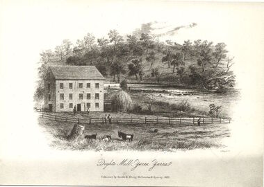
Print, Dight's Mill, Yarra Yarra
"In 1839 John Dight purchased Melbourne block 88, which included 26 acres of land along the Yarra River for £481 at the Port Phillip land sales held in Sydney. Dight was already in the business of flour milling and had a mill near Campbell Town in New South Wales called ‘Ceres’. In April 1840, he notified his customers through The Sydney Herald that he was leaving to go to Port Phillip. The first steam powered flour mill was constructed in Melbourne in 1841. Dight built his water powered mill, soon after, from bricks bought over from Tasmania. Dight used the river to power his mill: Water flowed along an inlet channel to turn an undershot water wheel. In order to regulate flow or to ensure flow for times when river levels were low, Dight constructed a rough stone weir. " (https://www.melbournewater.com.au/whatwedo/projectsaroundmelbourne/Documents/A_Short_History_of_Dights_Falls_Fact_Sheet.pdf) This work forms part of the collection assembled by the historian Dorothy Rogers, that was donated to the Kew Historical Society by her son John Rogers in 2015. The manuscripts, photographs, maps, and documents were sourced by her from both family and local collections or produced as references for her print publications. Many were directly used by Rogers in writing ‘Lovely Old Homes of Kew’ (1961) and 'A History of Kew' (1973), or the numerous articles on local history that she produced for suburban newspapers. Most of the photographs in the collection include detailed annotations in her hand. The Rogers Collection provides a comprehensive insight into the working habits of a historian in the 1960s and 1970s. Together it forms the largest privately-donated collection within the archives of the Kew Historical Society.An engraving of Dight's Mill on the Yarra. The image was originally published in Sands & Kenny, Melbourne & Sydney. Dorothy Rogers reproduced the print in 'A History of Kew' (1973). It faces page 8.Published by Sands & Kenny, Melbourne & Sydney, 1856dight's mill, dorothy rogers, dight's falls, yarra river, kew, john dight -
 Kew Historical Society Inc
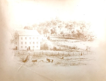
Print, Sands & Kenny, Dights Mill, 1856
"In 1839 John Dight purchased Melbourne block 88, which included 26 acres of land along the Yarra River for £481 at the Port Phillip land sales held in Sydney. Dight was already in the business of flour milling and had a mill near Campbell Town in New South Wales called ‘Ceres’. In April 1840, he notified his customers through The Sydney Herald that he was leaving to go to Port Phillip. The first steam powered flour mill was constructed in Melbourne in 1841. Dight built his water powered mill, soon after, from bricks bought over from Tasmania. Dight used the river to power his mill: Water flowed along an inlet channel to turn an undershot water wheel. In order to regulate flow or to ensure flow for times when river levels were low, Dight constructed a rough stone weir." (Melbourne Water)Dights Mill. Reproduction of a book plate from an original wood engraving, showing Dights Mill and Falls on the River Yarra. The image was originally published in Sands & Kenny, Melbourne & Sydney.Annotation on reverse: "Dights Flour".dights mill, yarra river -
 Surrey Hills Historical Society Collection
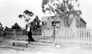
Photograph, St George's Church of England, Mont Albert working bee, early 1923 (1), 1923
The foundation stone for St George's Church of England, Mont Albert was laid in 1886 on land donated by Edward Dyer and the first service was preached in January 1887. From 1904 until 1907 it was known as Holy Trinity, Surrey Hills. The original church was weatherboard and replaced by a brick one in the Gothic Revival style which was designed by local architect George J V Blackburne, who also designed the Wesleyan School at Surrey Hills. The building was partly funded by donations, profits from a bazaar and concert, and other people donated furnishings. The church had boundaries along Mont Albert Road and St Georges Road. In 1998 the Church was sold and converted into a complex of units. Its current address is 19 St Georges Avenue, Mont Albert. Norman Carter took many photos of Surrey Hills and Mont Albert from the 1920s, in particular of events and activities associated with the Church of England.Black and white photo of 4 men at a working bee in the grounds of St George's Anglican Church in Mont Albert. Two men are on a scaffold working on the weatherboards of the church; the other two are working on fencing. One boundary is marked with a paling fence; the other has a section of picket fencing and a large open section with no fencing. There is a mature eucalyptus tree in front of the church; others are beyond the paling boundary fence. The church itself is a simply constructed weatherboard building.churches, holy trinity church, anglican church, st george's anglican church, working bees, norman brodley carter -
 Bendigo Historical Society Inc.
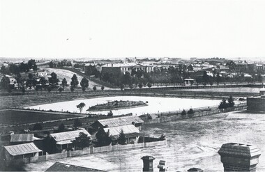
Photograph - LANDSCAPE VIEW OF BENDIGO
Black and white photograph. In foreground, roof and chimneys. Row of 3 small weatherboard houses with verandah, picket fences. 1 small and 1 larger building behind. Lake or dam with small island centre, stone brick wall with lookout tower at corner ( Bendigo gaol ) at right centre distanc,e large building. Benevolent Asylum. Many other buildings in distance. James Lerk 11.2.2000 ' view from the Corporate High School, Benevolent Asylum in centre' Unknown BHS member 5.11.1999 ' lower dam ( site of present tennis courts, Park Road, pumped out C 1926' Written on back of photo 'Bendigo Victoria 1860's, Sandhurst North view 100 miles north from Melbourne. C. Nettleton, Victorian Views'C. Nettleton ?place, landscape view, bendigo -
 Ballarat Heritage Services
Photograph - Church, Clare Gervasoni, Daylesford Uniting Church, 18/10/2015
The Daylesford Uniting Church (formerly Wesleyan /Methodist Church) was built in 1865, replacing an earlier Wesleyan Chapel built in 1861 which is still on site and known as the Sunday School (2024). The foundaton stone for the newer, current church was laid on 12 June 1865, designed by Architects Crouch and Wilson the structure was built in early English Gothic style. The first service was held in the new church on 10 December 1865. It is of interest for its brick broach spire, diapered brick façade and spacious interior with aisles separated from the nave by slender columns. The church organ was installed and built in 1888 by William Anderson and boasts an impressive 724 pipes, many of which are decorated with Christian symbols. This organ is a rare example of Anderson’s work and is his only instrument in Western Victoria. It is classified by the National Trust of Australia (Victoria) as being of state significance. The organ was renpvated in 1979-80 by Leighton Turner. It has 2 manuals, 14 speaking stops, 3 couplers, tracker action, Gt: 8.8 divided.8.4.4.2-2/3.2. Sw: 8.8.4.2.8. Ped: 16. In the 1880s the decline in mining led to the congregation considering ways to reduce debt. Rent was received from pew hire as well as organ concerts and annual fairs. By the end of the 19th century the church had settled into a pattern of steady parish life. The 1950s and 1960s were really the glory days of the church with an active Sunday School, tennis clubs and vibrant social activity as well as many worshippers at Sunday services. The final service was held at the church on 21 April 2024.A redbrick church on stone foundation in Daylesforddaylesford uniting church, daylesford methodist church, daylesford, john mitchell uniting church, daylesford wesleyan church, crouch and wilson, daylesford uniting sunday school -
 Ballarat Heritage Services
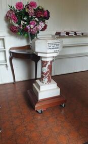
Photograph - Church, Clare Gervasoni, Daylesford Uniting Church Baptisimal Font, 2023, 04/03/2023
The Daylesford Uniting Church (formerly Wesleyan /Methodist Church) was built in 1865, replacing an earlier Wesleyan Chapel built in 1861 which is still on site and known as the Sunday School (2024). The foundaton stone for the newer, current church was laid on 12 June 1865, designed by Architects Crouch and Wilson the structure was built in early English Gothic style. The first service was held in the new church on 10 December 1865. It is of interest for its brick broach spire, diapered brick façade and spacious interior with aisles separated from the nave by slender columns. The church organ was installed and built in 1888 by William Anderson and boasts an impressive 724 pipes, many of which are decorated with Christian symbols. This organ is a rare example of Anderson’s work and is his only instrument in Western Victoria. It is classified by the National Trust of Australia (Victoria) as being of state significance. The organ was renpvated in 1979-80 by Leighton Turner. It has 2 manuals, 14 speaking stops, 3 couplers, tracker action, Gt: 8.8 divided.8.4.4.2-2/3.2. Sw: 8.8.4.2.8. Ped: 16. In the 1880s the decline in mining led to the congregation considering ways to reduce debt. Rent was received from pew hire as well as organ concerts and annual fairs. By the end of the 19th century the church had settled into a pattern of steady parish life. The 1950s and 1960s were really the glory days of the church with an active Sunday School, tennis clubs and vibrant social activity as well as many worshippers at Sunday services. The final service was held at the church on 21 April 2024.A marble baptisimal font in Daylesford Uniting Church.In loving memory of my dear husband The late Rev. T. Pollard James 28.9.41daylesford uniting church, daylesford methodist church, daylesford, john mitchell uniting church, daylesford wesleyan church, daylesford uniting sunday school, baptisimal font, t. pollard james -
 Ballarat Heritage Services
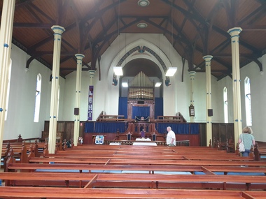
Photograph - Church, Clare Gervasoni, Daylesford Uniting Church Interior, 2023, 04/03/2023
The Daylesford Uniting Church (formerly Wesleyan /Methodist Church) was built in 1865, replacing an earlier Wesleyan Chapel built in 1861 which is still on site and known as the Sunday School (2024). The foundaton stone for the newer, current church was laid on 12 June 1865, designed by Architects Crouch and Wilson the structure was built in early English Gothic style. The first service was held in the new church on 10 December 1865. It is of interest for its brick broach spire, diapered brick façade and spacious interior with aisles separated from the nave by slender columns. The church organ was installed and built in 1888 by William Anderson and boasts an impressive 724 pipes, many of which are decorated with Christian symbols. This organ is a rare example of Anderson’s work and is his only instrument in Western Victoria. It is classified by the National Trust of Australia (Victoria) as being of state significance. The organ was renpvated in 1979-80 by Leighton Turner. It has 2 manuals, 14 speaking stops, 3 couplers, tracker action, Gt: 8.8 divided.8.4.4.2-2/3.2. Sw: 8.8.4.2.8. Ped: 16. In the 1880s the decline in mining led to the congregation considering ways to reduce debt. Rent was received from pew hire as well as organ concerts and annual fairs. By the end of the 19th century the church had settled into a pattern of steady parish life. The 1950s and 1960s were really the glory days of the church with an active Sunday School, tennis clubs and vibrant social activity as well as many worshippers at Sunday services. The final service was held at the church on 21 April 2024.A redbrick church on stone foundation in Daylesforddaylesford uniting church, daylesford methodist church, daylesford, john mitchell uniting church, daylesford wesleyan church, crouch and wilson, daylesford uniting sunday school -
 Ballarat Heritage Services
Photograph - Church, Clare Gervasoni, Daylesford Uniting Church, 2023, 04/03/2023
The Daylesford Uniting Church (formerly Wesleyan /Methodist Church) was built in 1865, replacing an earlier Wesleyan Chapel built in 1861 which is still on site and known as the Sunday School (2024). The foundaton stone for the newer, current church was laid on 12 June 1865, designed by Architects Crouch and Wilson the structure was built in early English Gothic style. The first service was held in the new church on 10 December 1865. It is of interest for its brick broach spire, diapered brick façade and spacious interior with aisles separated from the nave by slender columns. The church organ was installed and built in 1888 by William Anderson and boasts an impressive 724 pipes, many of which are decorated with Christian symbols. This organ is a rare example of Anderson’s work and is his only instrument in Western Victoria. It is classified by the National Trust of Australia (Victoria) as being of state significance. The organ was renpvated in 1979-80 by Leighton Turner. It has 2 manuals, 14 speaking stops, 3 couplers, tracker action, Gt: 8.8 divided.8.4.4.2-2/3.2. Sw: 8.8.4.2.8. Ped: 16. In the 1880s the decline in mining led to the congregation considering ways to reduce debt. Rent was received from pew hire as well as organ concerts and annual fairs. By the end of the 19th century the church had settled into a pattern of steady parish life. The 1950s and 1960s were really the glory days of the church with an active Sunday School, tennis clubs and vibrant social activity as well as many worshippers at Sunday services. The final service was held at the church on 21 April 2024.A redbrick church on stone foundation in Daylesforddaylesford uniting church, daylesford methodist church, daylesford, john mitchell uniting church, daylesford wesleyan church, crouch and wilson, daylesford uniting sunday school -
 Ballarat Heritage Services
Photograph - Church, Clare Gervasoni, Former Daylesford Wesleyan Chapel, 2023, 04/03/2023
The Daylesford Uniting Church (formerly Wesleyan /Methodist Church) was built in 1865, replacing an earlier Wesleyan Chapel built in 1861 which is still on site and known as the Sunday School (2024). The foundaton stone for the newer, current church was laid on 12 June 1865, designed by Architects Crouch and Wilson the structure was built in early English Gothic style. The first service was held in the new church on 10 December 1865. It is of interest for its brick broach spire, diapered brick façade and spacious interior with aisles separated from the nave by slender columns. The church organ was installed and built in 1888 by William Anderson and boasts an impressive 724 pipes, many of which are decorated with Christian symbols. This organ is a rare example of Anderson’s work and is his only instrument in Western Victoria. It is classified by the National Trust of Australia (Victoria) as being of state significance. The organ was renpvated in 1979-80 by Leighton Turner. It has 2 manuals, 14 speaking stops, 3 couplers, tracker action, Gt: 8.8 divided.8.4.4.2-2/3.2. Sw: 8.8.4.2.8. Ped: 16. In the 1880s the decline in mining led to the congregation considering ways to reduce debt. Rent was received from pew hire as well as organ concerts and annual fairs. By the end of the 19th century the church had settled into a pattern of steady parish life. The 1950s and 1960s were really the glory days of the church with an active Sunday School, tennis clubs and vibrant social activity as well as many worshippers at Sunday services. The final service was held at the church on 21 April 2024.A stone church in Daylesford. Originally built at the Daylesford Wesleyan Chapel, it was later used as the Daylesford Uniting Church Sunday School. daylesford uniting church, daylesford methodist church, daylesford, john mitchell uniting church, daylesford wesleyan church, daylesford uniting sunday school -
 Ballarat Heritage Services
Photograph - Church, Clare Gervasoni, Daylesford Uniting Church John Mitchell Memorial Hall, 2023, 04/03/2023
The Daylesford Uniting Church (formerly Wesleyan /Methodist Church) was built in 1865, replacing an earlier Wesleyan Chapel built in 1861 which is still on site and known as the Sunday School (2024). The foundaton stone for the newer, current church was laid on 12 June 1865, designed by Architects Crouch and Wilson the structure was built in early English Gothic style. The first service was held in the new church on 10 December 1865. It is of interest for its brick broach spire, diapered brick façade and spacious interior with aisles separated from the nave by slender columns. The church organ was installed and built in 1888 by William Anderson and boasts an impressive 724 pipes, many of which are decorated with Christian symbols. This organ is a rare example of Anderson’s work and is his only instrument in Western Victoria. It is classified by the National Trust of Australia (Victoria) as being of state significance. The organ was renpvated in 1979-80 by Leighton Turner. It has 2 manuals, 14 speaking stops, 3 couplers, tracker action, Gt: 8.8 divided.8.4.4.2-2/3.2. Sw: 8.8.4.2.8. Ped: 16. In the 1880s the decline in mining led to the congregation considering ways to reduce debt. Rent was received from pew hire as well as organ concerts and annual fairs. By the end of the 19th century the church had settled into a pattern of steady parish life. The 1950s and 1960s were really the glory days of the church with an active Sunday School, tennis clubs and vibrant social activity as well as many worshippers at Sunday services. The final service was held at the church on 21 April 2024.A small hall in the grounds of Daylesford Uniting Church. John Mitchell was a teacher and superintendent from September 1861 to 1921. The hall was still in existence in August 2024.John Mitchell Memorial Hall 1931daylesford uniting church, daylesford methodist church, daylesford, john mitchell uniting church, daylesford wesleyan church, daylesford uniting sunday school, john mitchell -
 Vision Australia
Photograph - Image, 1868 Time Capsule at St Kilda Road, 1985
In 1868, with the laying of the foundation stone, a time capsule was placed containing four newspapers of the day (Saturday 25 January, 1868 - The Age, The Argus, The Sun and The Telegraph: St Kilda, Prahran and South Yarra Guardian), the first Annual report of the Victorian Asylum and School for the Blind (1867), 11 coins from the Victorian regency and an illustration of the proposed building at St Kilda Road. An undated note also describes a piece of parchment in the time capsule, which contained a list of names of committee members and relevant people involved in the construction of the building, such as Crouch & Wilson; however no image of this has been located. In 1991, this time capsule was opened as part of 125 year celebrations and the contents were put on display. The capsule was the size of a house brick and buried underneath the foundation stone. It was made of metal and had to be sawn open to reveal the contents. These images are of the items found inside the time capsule. Additionally there are low res images of these items plus some photographs taken on the day: Brian Howe, Minister for Health, holds the time capsule whilst Trent Willard and Janice Johns, current RVIB students, stand by during the raising ceremony; Miss Molly Miller, the oldest surviving student, and Mr Percy Raufer, great grand nephew of Mary-Ann Raufer who was pupil number 6 and enrolled in the school in January 29th, 1866 look at the items found in the time capsule. In 2005 a new time capsule was buried, including an electronic copy of the 1867 report and drawing of St Kilda Road from the 1868 time capsule.Photographs and scans of items found inside the time capsuleroyal victorian institute for the blind, brian howe, trent willard, janice johns, molly miller, percy raufer, time capsule -
 Eltham District Historical Society Inc
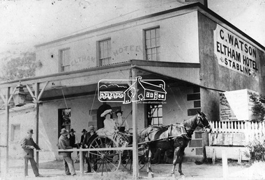
Photograph, Watson's Eltham Hotel, Maria Street, Eltham, c.1900
Christoher Watson's Eltham Hotel, cnr Maria Street (Main Road) and Pitt Street, Eltham. Christopher Watson in centre (bareheaded). Reproduced on p60 of 'Pioneers & Painters' The hotel was constructed in the 1850s immediately following the discovery of gold in Victoria. The original founder, a Mr Warren. engaged a builder named Wallace, to erect the hotel, and being unable to finance it, the story goes, handed it over to Mr Wallace, who finished the job, and received the first licence. The building was constructed of hard basaltic blue stone, quarried in the Eltham district, and partly of bricks made at Eltham. At that time the town owned not only an hotel, but a flour mill, a brewery, a brickworks, and other important industries. The hotel was carried on for the benefit of the first owners for over 30 years and was then purchased by Mr Chris Watson. The hotel was in the early days a well-known resting place for the gold diggers during the gold rush at Woods' Point. A new hotel was erected on the same site by Mr H. Watson in 1925.This photo forms part of a collection of photographs gathered by the Shire of Eltham for their centenary project book,"Pioneers and Painters: 100 years of the Shire of Eltham" by Alan Marshall (1971). The collection of over 500 images is held in partnership between Eltham District Historical Society and Yarra Plenty Regional Library (Eltham Library) and is now formally known as the 'The Shire of Eltham Pioneers Photograph Collection.' It is significant in being the first community sourced collection representing the places and people of the Shire's first one hundred years.Digital imagechristopher watson, eltham, hotel, main road, maria street, pioneers and painters, pitt street, shire of eltham pioneers photograph collection, watson's hotel -
 Eltham District Historical Society Inc
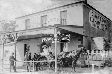
Photograph, Watson's Eltham Hotel, Maria Street, Eltham, c.1900
Christoher Watson's Eltham Hotel, cnr Maria Street (Main Road) and Pitt Street, Eltham. Christopher Watson in centre (bareheaded). Reproduced on p60 of 'Pioneers & Painters' The hotel was constructed in the 1850s immediately following the discovery of gold in Victoria. The original founder, a Mr Warren. engaged a builder named Wallace, to erect the hotel, and being unable to finance it, the story goes, handed it over to Mr Wallace, who finished the job, and received the first licence. The building was constructed of hard basaltic blue stone, quarried in the Eltham district, and partly of bricks made at Eltham. At that time the town owned not only an hotel, but a flour mill, a brewery, a brickworks, and other important industries. The hotel was carried on for the benefit of the first owners for over 30 years and was then purchased by Mr Chris Watson. The hotel was in the early days a well-known resting place for the gold diggers during the gold rush at Woods' Point. A new hotel was erected on the same site by Mr H. Watson in 1925.Early photo of Eltham Hotel which has been on site in various forms since mid 1800sSepia photograph mounted on cardInscribed on back: "Property of Mr Albert Watson, 53 Yarra St, Heidelberg. Christopher Watson (bare headed) Given to Marion Huggett December 1977 c.1900 son of Watson Snr behind cart"christopher watson, eltham, eltham hotel, main road, maria street, pioneers and painters, pitt street, shire of eltham pioneers photograph collection, watson's hotel -
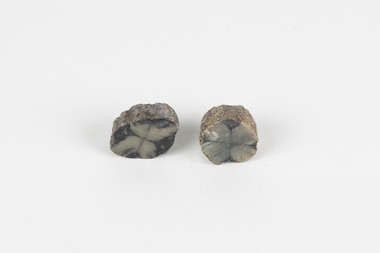 The Beechworth Burke Museum
Geological specimen - Chiastolite
It is made up of andalusite. Andalusite is a rock-forming mineral, sometimes found in granite or schist. It is often used to make glass, ceramic products, chemicals, and heat-resistant bricks as it can withstand high temperatures without changing. The chiastolite contains particles of graphite, which arranges in geometric patterns. When crystal growth occurs in the rock, the granite particles concentrate at crystal interfaces and can result in cross shapes. These ‘cross stones’ have been valued and used for their spiritual or religious meaning and used as charms, gems, or amulets. Chiastolite was first discovered in 1754, seen in a description in a published book by a palaeontologist, Franciscan priest, and Spanish author, Jose Torrubia. Deposits have been found in Australia, France, the USA, Chile, Canada, Spain, Brazil, Sri Lanka, and Russia. Deposits have been found in Western Australia and South Australia. This particular specimen was found in Bimbowrie, South Australia. Other chiastolite specimens have been found in Bimbowrie, along with jasper, quartz, and aventurine in the form of rolled pebbles or schist. This chiastolite specimen is socially and historically significant. It is a very rare sort of andalusite mineral. It is from one of only two locations where it is regularly found in Australia. The carbon cross has made it an important religious symbol in the past. Its ability to withstand high temperatures has made it a common ingredient in heat-resistant bricks and ceramics today. This specimen is part of a larger collection of geological and mineral specimens collected from around Australia (and some parts of the world) and donated to the Burke Museum between 1868-1880. A large percentage of these specimens were collected in Victoria as part of the Geological Survey of Victoria that begun in 1852 (in response to the Gold Rush) to study and map the geology of Victoria. Collecting geological specimens was an important part of mapping and understanding the scientific makeup of the earth. Many of these specimens were sent to research and collecting organisations across Australia, including the Burke Museum, to educate and encourage further study.A metamorphic mineral consisting of andalusite, with a cross shaped graphite pattern in colours of grey, brown and yellowburke museum, beechworth, geological, geological specimen, andalusite, chiastolite, geometric, cross stone, spiritual, religious, australia, south australia, bimbowrie, quartz, jasper, aventurine, schist -
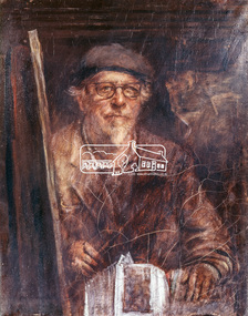 Eltham District Historical Society Inc
Photograph, Jorgensen, Justus, 1893-1975, Self portrait, Justus Jorgensen, founder of Montsalvat, c.1955
Founder of Montsalvat Reproduced Page 106 of Pioneers & Painters, edited by Alan Marshall (1971) Note: print in book and print copy are mirror imaged There was probably little earth building done in the district in this century until 1934, when Justus Jorgensen, architect and artist, bought land in Eltham and with his students and followers commenced to build the fascinating complex of buildings now know as ‘Montsalvat’. These buildings and his use of materials, both local stone and earth, and reclaimed materials, were to have a remarkable influence on the Eltham district-particularly in the period following World War II. The first building at ‘Montsalvat’ was a picturesque house of or rammed earth with a high-pitched roof. Jorgensen has used a variety of building materials but it is possibly his use of earth, both pise-de-terre and mud brick, which has had the most influence on the environmental building in Eltham in the post war years. By the end of the 1940s, an impressive array of adobe and pise buildings had been completed. – Alan Marshall, 1971, “Pioneers & Painters”This photo forms part of a collection of photographs gathered by the Shire of Eltham for their centenary project book,"Pioneers and Painters: 100 years of the Shire of Eltham" by Alan Marshall (1971). The collection of over 500 images is held in partnership between Eltham District Historical Society and Yarra Plenty Regional Library (Eltham Library) and is now formally known as the 'The Shire of Eltham Pioneers Photograph Collection.' It is significant in being the first community sourced collection representing the places and people of the Shire's first one hundred years.Digital image 4 x 5 inch Clr Reversal (3) Print 21 x 16.5 cm (printed in mirror image)justus jorgensen, montsalvat, pioneers and painters, shire of eltham pioneers photograph collection -
 Eltham District Historical Society Inc
Photograph - Digital Photograph, Marguerite Marshall, Gordon Ford's Garden, 'Fulling', Pitt Street, Eltham, 10 November 2006
'Fulling', the half-hectare property at Pitt Street, Eltham was the home of landscape designer Gordon Ford and his wife Gwen. Ford bought the property in 1948, originally part of an orchard. The garden encapsulates the major trends of Australian garden design in the second half of the 20th century. The garden design is based on mass (plants) and void (paths and pools), textures and forms. It epitomises the Eltham style because of its relaxed informality and attraction to native wildlife. The mud brick house and designed and built by Ford commenced in 1948. Several extensions were added up to 1970 and were built by Graham Rose (Source: information panel for exhibition, n.d.) Covered under Heritage Overlay, Nillumbik Planning Scheme. Published: Nillumbik Now and Then / Marguerite Marshall 2008; photographs Alan King with Marguerite Marshall.; p147 A narrow timber gate opens onto a garden that has had a huge impact on natural garden development in Australia since the 1950s.1 Fulling, the half-hectare property at Pitt St, Eltham, was the home of the landscape designer, Gordon Ford, who died in 1999. The garden ‘encapsulates the major trends of Australian garden design in the second half of the 20th century...and epitomises the Eltham style of garden’.2 It in turn, was influenced by several Victorian major landscape designers of the mid 20th century – Ellis Stones, Peter Glass and Edna Walling. The gate opens onto a sandy gravel path, one of several, which wind around dramatic pools and what appear to be natural bush, but on close inspection are carefully integrated native, indigenous and exotic plantings. Retaining walls and steps of rock through the garden link different terrace levels. Lichen-covered boulders serve as steps across a pool, leading to the triple level mud-brick house. Ford bought the property, which was originally part of an orchard, in 1948. As the son of a Presbyterian minister, Ford received a good education, which included learning Latin. This was advantageous when he worked in plant sales for the Forestry Commission, before the Second World War. In the late 1940s, however, Ford turned to building and landscape gardening. He worked on the Busst house, an early mud-brick building designed by Alistair Knox and at the same time, Ford was employed by Ellis Stones. Knox described Ford as, ‘one of the funniest men of the district. ...Rocky’s (Ellis Stones) Depression stories and Gordon’s memory and quick tongue made the jobs the most enjoyable of all those hysterical times that made Eltham the centre of the eternal laugh, between the years of 1945 and 1950’.3 Ford’s house, like so many after the war, was built progressively, as more space was needed and formerly scarce materials became available. It began with an army-shed of timber-lined walls, now used as the kitchen. Ford then built what is now the lounge room, and the house grew ‘like topsy and on a shoestring,’ says his widow Gwen. A lot of second-hand materials such as window frames were used, a style made famous particularly with their extensive use at Montsalvat, the Eltham Artists’ Colony. The house was constructed as a joint venture with friends, including artist Clifton Pugh, who built Ford’s bedroom for £10. The polished floorboards and solomite (compressed straw) ceilings, interspersed with heavy beams, exude warmth. The result is a home of snug spaces, with soft light and garden vistas. Several other mud-brick buildings were constructed as needed, including a studio and units for bed-and-breakfast clients. The garden, which has been part of the Open Garden Scheme since the mid 1980s, is based on a balance of mass (plants) and void (paths and pools), textures and forms. It epitomises the Eltham style because of its relaxed informal ethos and attracts native animals. Wattlebirds, scrub wrens, pardalotes, currawongs, owls and even kangaroos, have been seen at Fulling. Gwen, a former English teacher who has worked on the garden since around 1970, urged and helped Ford write his book, The Natural Australian Garden.4 Several of Ford’s favourite trees are in the garden, including the native Casuarina or She-Oak. In spring, the garden is dusted with the purple Orthrosanthus multiflorus or blue native irises and rings with the calls of birds attracted to plants like the callistemons, correas and grevilleas.This collection of almost 130 photos about places and people within the Shire of Nillumbik, an urban and rural municipality in Melbourne's north, contributes to an understanding of the history of the Shire. Published in 2008 immediately prior to the Black Saturday bushfires of February 7, 2009, it documents sites that were impacted, and in some cases destroyed by the fires. It includes photographs taken especially for the publication, creating a unique time capsule representing the Shire in the early 21st century. It remains the most recent comprehenesive publication devoted to the Shire's history connecting local residents to the past. nillumbik now and then (marshall-king) collection, eltham, fulling, gordon ford garden, pitt street, eltham mud brick buildings, mud brick house -
 Kew Historical Society Inc
Plan, Melbourne & Metropolitan Board of Works : Borough of Kew : Detail Plan No.1568, 1905
The Melbourne and Metropolitan Board of Works (MMBW) plans were produced from the 1890s to the 1950s. They were crucial to the design and development of Melbourne's sewerage and drainage system. The plans, at a scale of 40 feet to 1 inch (1:480), provide a detailed historical record of Melbourne streetscapes and environmental features. Each plan covers one or two street blocks (roughly six streets), showing details of buildings, including garden layouts and ownership boundaries, and features such as laneways, drains, bridges, parks, municipal boundaries and other prominent landmarks as they existed at the time each plan was produced. (Source: State Library of Victoria)This plan forms part of a large group of MMBW plans and maps that was donated to the Society by the Mr Poulter, City Engineer of the City of Kew in 1989. Within this collection, thirty-five hand-coloured plans, backed with linen, are of statewide significance as they include annotations that provide details of construction materials used in buildings in the first decade of the 20th century as well as additional information about land ownership and usage. The copies in the Public Record Office Victoria and the State Library of Victoria are monochrome versions which do not denote building materials so that the maps in this collection are invaluable and unique tools for researchers and heritage consultants. A number of the plans are not held in the collection of the State Library of Victoria so they have the additional attribute of rarity.Original survey plan, issued by the MMBW to a contractor with responsibility for constructing sewers in the area identified on the plan within the Borough of Kew. The plan was at some stage hand-coloured, possibly by the contractor, but more likely by officers working in the Engineering Department of the Borough and later Town, then City of Kew. The hand-coloured sections of buildings on the plan were used to denote masonry or brick constructions (pink), weatherboard constructions (yellow), and public buildings (grey). Plan No.1568 covers the area bounded by Cotham Road, John Street, Sackville Street, and Edward Street. Alfred Street and Rowland Street are in shown in the middle of the plan. The two most notable buildings shown are ‘St Helliers’, the home of the Dumaresq family, and St Hilary’s Church and school. While the colours used to indicate St Hilary’s are grey as in other civic/public buildings, the first St Hilary’s Anglican Church was at this stage constructed in weatherboard. At the left of the plan, facing Sackville Street is a house named ‘Glencara’. The 1988 ‘Kew Conservation Study’ recorded that “The first documentary evidence of this house comes from Rate Books which record that in 1893 a Mrs Treadway was the owner of this building with an N.A.V. of £81? At that date the occupier of the house was Charles B. Kelly, a clerk, while by 1910 Kelly had become the owner of the property described in that year ‘as a six-roomed stone, brick and wood house with stables and outbuildings’”. Contrary to this description, the 1905 plan indicates that the house was entirely constructed of masonry.melbourne and metropolitan board of works, detail plans, mmbw 1568 -
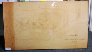 Bendigo Historical Society Inc.
Map - CONTOUR PLAN OF THE GOVERNMENT CAMP SANDHURST 1854, 1994
Contour map (copy) of the Government Camp Sandhurst, 1854. Map is mounted on coreflute and laminated. Written in bottom righthand corner 'Contour Plan of the Government Camp, Sandhurst. Dec 1854. Signed by Richard Larritt, Assistant Surveyor, 11th December 1854.' Shown on map: Pall Mall, Bendigo Creek, Commissioner's Gully, View Place (now View Street), Post Office, Bank of Victoria, District Surgeon, Sandhurst Fire Brigade, Police Hospital, Flagstaff, Gold Office, License Shed, Military Barracks, Stables, Commissioner's Buildings, Police Office. Old Cemetery, Garden. Reference on righthand side: 'Stone or brick buildings are tinted in crimson. Wooden buildings tinted in Indian Ink. Tents and other temporary structures tinted in Burnt Sienna.' Scale of Chains, on bottom of map. Sticker on bottom left hand corner and back of map ' Presented by Survey and Mapping, Victoria, 7th Octber, 1994'.map, bendigo, government camp, pall mall, bendigo creek, commissioner's gully, view place (now view street), post office, bank of victoria, district surgeon, sandhurst fire brigade, police hospital, flagstaff, gold office, license shed, military barracks, stables, commissioner's buildings, police office. old cemetery, garden. , survey and mapping victoria. sandhurst, bendigo. -
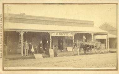 Bacchus Marsh & District Historical Society
Photograph, George Dickie Bakery Main Street Bacchus Marsh 1883
George Dickie arrived in the Bacchus Marsh area around 1857. In 1863, he married Ellen Ross Anderson, and after five years of farming in Coimadai, they moved into Bacchus Marsh and established a business. In 1866 he bought the bakery business which had been established by James Boatwood and later conducted by William Watson. This business was in Main Street and is shown in this image during the time it was owned and operated by George Dickie. Ellen and George Dickie had seven children, two sons and five daughters. In his later years he changed the business into a general store and also engaged in grain dealing. He died in 1904 but the business was carried on by his sons until sold in March 1916 to a Charles Medling from Numurkah. The building was later demolished in 1927 to make way for four new shops.Small sepia 'carte de viste' style unframed photograph on card with gold border framing photograph. Housed in the Jeremeas Family Album which contains photographs of Bacchus Marsh and District in 1883 by the photographers Stevenson and McNicoll. The picture shows the business of George Dickie which was located in Main Street Bacchus Marsh. The building is a brick or stone structure with a verandah along the entire frontage of the building. Standing in front of the building is a group of adults and children. On the far left is a man wearing a dress coat and hat. He is possibly Mr. George Dickie the owner of this business. To his left are some younger and older children, and a woman, possibly Mrs DIckie. In the background in the doorway is a young boy with woman behind him. On the right of the picture on the street is a man standing alongside a horse and cart. Some advertising signs are leaning against the shop, footpath and verandah pillar. One of them says 'Chaff, Oats, Bran'. Printed On the front: Stevenson & McNicoll. Photo. 108 Elizabeth St. Melbourne. COPIES CAN BE OBTAINED AT ANY TIME. On the back: LIGHT & TRUTH inscribed on a banner surmounted by a representation of the rising sun. Copies of this Portrait can be had at any time by sending the Name and Post Office Money Order or Stamps for the amount of order to STEVENSON & McNICOLL LATE BENSON & STEVENSON, Photographers. 108 Elizabeth Street, MELBOURNE. stevenson and mcnicoll 1883 photographs of bacchus marsh and district, bakeries, shops bacchus marsh, george dickie 1831-1904, dickie family bacchus marsh -
 Bacchus Marsh & District Historical Society
Photograph, Woolpack Stables Bacchus Marsh 1883
This image is one of a series of photographs taken by Melbourne based photographers Stevenson and McNicoll who visited Bacchus Marsh and its nearby districts between September and November 1883. James Elijah Crook settled in Bacchus Marsh in 1841 and soon after held a licence for a lodging house on the Portland Road. In about 1845, he built the first Woolpack Inn, a slab building of eight rooms. This was replaced in 1850 with a “stately country villa” of brick and stone. The stables were also built in 1850 to accommodate twenty horses. In 1851, Crook established a coach service to the goldfields. After being in use as a Court of Petty Sessions, the Woolpack Inn lost its licence and closed in 1862. After this date, Crook took an interest in horse-breeding and continued to use the stables for his horses. His most notable success was with his horse, Saladin, which won the Australia Cup in 1872, after two exciting dead-heats with The Flying Dutchman. James Elijah Crook died in 1889. The Woolpack Inn and Stables were sold and then used as a hay and corn store. In 1910 the site was leased for use as an abattoir. The Woolpack Inn was demolished in 1931. The site is still in use as an abattoir. Little remains of the original stables.Small sepia 'carte de viste' style unframed photograph on card with gold border framing photograph. Housed in the Jeremeas Family Album which contains photographs of Bacchus Marsh and District in 1883 by the photographers Stevenson and McNicoll. The photo is of a gable-roofed commercial stables with shingled roofing, and white-washed render to the walls, standing in a large cleared yard. There is a skillion extension to the south-west corner. On the front (northern) wall can be seen a door and three windows, two large and one small paned window in the centre. The eastern window is paned, while the western window has louvres and a pull-out blind. Three S shaped stays can be seen on the northern wall. Along the western wall are two more windows and doors. A mound of hay lies at the north-western corner. Standing at the front of the stables is a group of five men and two boys, one holding a large dog. Four of the men are dressed in workman’s clothing and some are holding tools of their trade. The man at the back is wearing more formal clothes and has distanced himself from the workmen. The pole against which one of the workmen is leaning appears to have damage along one side. This pole may have been used as a hitching post as there is a footrest installed lower down to make mounting easier. Printed On the front: Stevenson & McNicoll. Photo. 108 Elizabeth St. Melbourne. COPIES CAN BE OBTAINED AT ANY TIME. On the back: LIGHT & TRUTH inscribed on a banner surmounted by a representation of the rising sun. Copies of this Portrait can be had at any time by sending the Name and Post Office Money Order or Stamps for the amount of order to STEVENSON & McNICOLL LATE BENSON & STEVENSON, Photographers. 108 Elizabeth Street, MELBOURNE. stevenson and mcnicoll 1883 photographs of bacchus marsh and district -
 Bendigo Military Museum
Document - CENOTAPH RESTORATION BENDIGO, City of Bendigo, C.1984
This Document is the first in several plus photos and an article following the restoration of the Bendigo Cenotaph (Replica of the Cenotaph in Whitehall London). The letter is from the City of Bendigo Municipal Offices Lyttleton Terrace Bendigo is dated 13th April 1984 from the Building Surveyor Mr P.W. Phillips to Mr J.K. Barnes Secretary Bendigo RSL Sub Branch P.O.Box 449 Bendigo. Letter states that the Surveyors Report was adopted by Council on 21st November 1983 and would then be considered at Estimates later in the year. The Surveyors Report pages 2/3 gives a background report back to 1976 re its condition by the Building Surveyor at the time Mr R.H. Chellow and that an offer to fund at no cost was offered. Unfortunately this did not proceed. Council had approved funds for Stone work etc in the 1976/77 Estimates. The report is under several headings “Restoration of Cenotaph” being the history to this point. “Nature of Repairs Neccessary” - in brief, Extensive repairs, Granite structure is good, Sandstone needs 90% replacement, brick core in good order. “Estimate of Cost” A price of $30,000 for Budget purposes but could be as low as $25,000. “Recommendation” That Restoration be referred to the 1984/85 Estimates for consideration, copies to Bendigo RSL and State President RSL.Document 3 pages stapled together, front page is A4 and the pages 2/3 is Foolscap.Front page has a top section in blue, on the left is a depiction of a Mine Poppet Head, on the right is a Coat of Arms. The letter section is in black type, signed at the bottom in blue pen. Pages 2/3 are all black print.Page 1 points, Coat of Arms, “City of Bendigo - Progress”. “1968/84” - PWP:LT 32.7.1”. Page 2/3, “Building Surveyors Report - 21st November 1983 - B42/83 - (32.7.1)”brsl, smirsl, cenotaph, restoration -
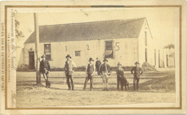
 Bacchus Marsh & District Historical Society
Photograph, Mechanics Institute and Hall Main Street, Bacchus Marsh 1883
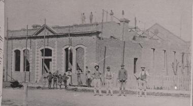
A Mechanics Institute in Bacchus Marsh dates from sometime in the 1850s. The first Mechanics Institute Hall was erected in 1858 in Young Street.(Victorian Collections no.659.) In 1883 a new and larger Mechanics Institute Hall was built in Main Street. The new hall cost 2,000 pounds to construct. It was opened by Sir William Clarke on 21 November 1883. The Mechanics Institute Library and rooms at the front of the hall were removed when the building was renovated in 1971. The building still stands and is used as a public hall.Small black and white 'carte de viste' style unframed photograph on card with gold border framing photograph. Housed in the Jeremeas Family Album which contains photographs of Bacchus Marsh and District in 1883 by the photographers Stevenson and McNicoll. The photo is of a substantial brick building under construction. Scaffolding support poles line the front and also can be seen on the top and back of the building. On the rooftop stand three workmen, with a further seven men standing at the front. Three men lean or stand casually at the front in casual poses. Four men stand in a line in another group on the roadway, perhaps indicating that they are master craftsmen. One of these men holds a tool of his trade, resembling a bricklayer’s mortar board. Six boys can be seen, four in a rather jaunty pose. In an indication of its public significance, the four front windows and door are arched and have decorative stone work in the side panels. A picket fence marks the boundary of the adjacent block.Printed On the front: Stevenson & McNicoll. Photo. 108 Elizabeth St. Melbourne. COPIES CAN BE OBTAINED AT ANY TIME. On the back: LIGHT & TRUTH inscribed on a banner surmounted by a representation of the rising sun. Copies of this Portrait can be had at any time by sending the Name and Post Office Money Order or Stamps for the amount of order to STEVENSON & McNICOLL LATE BENSON & STEVENSON, Photographers. 108 Elizabeth Street, MELBOURNE. stevenson and mcnicoll 1883 photographs of bacchus marsh and district, mechanics institutes, halls, bacchus marsh mechanics institute -
 Eltham District Historical Society Inc
Photograph, Jim Connor, Eltham - Montmorency Uniting Church, 810 Main Rd, Eltham, 10 July 2023
Located on the corner of Main Road and John Street, the church first served the community as the Eltham Wesleyan Church since 1881. It became the Eltham Methodist Church in 1902, the year it united with the Primitive Methodists. Eltham Wesleyans first worshipped together in the home of William and Mary Crozier, on 24 acres bounded by Mount Pleasant Road and Pitt Street. From there they moved to a slab and bark hut in 1855 (this later served as the first school run by David Clark prior to the building of a new school in Dalton Street) and the members then built a chapel in 1858 on Lot 20, Henry Street (later to become the Rechabite Hall and Eltham Public Hall). The present church on John Street was designed by architects Crouch and Wilson in the Early English Gothic style with biochrome brick window frames, buttress heads and pinnacle. Church member George Stebbing built the church, the foundations were constructed with stone from the walls of the first Eltham State Primary School (No. 209) building which collapsed in 1874 and were purchased by Robert David Taylor. Stebbing was also responsible for building St Margaret’s Church and Shillinglaw Cottage. The Roll of Honour, which presently hangs in the church hall (which also doubles as the Opportunity Shop) lists 27 members of the congregation who served in the First World War, 11 of whom never returned. The red-brick Church Hall was opened in 1931 and in 1971 further additions linked the hall and church, including a foyer, vestry, meeting room and toilets reflecting the Eltham style of that time with its simplicity, extensive clear glass, reused baked clay-bricks from the 1881 church, heavy ceiling beams and compressed straw ceiling. On June 26, 1977, the church became part of the new Uniting Church in Australia consisting of the former Methodist and Congregational and most of the Presbyterian Churches. Following of declining numbers of worshippers, the church merged with the Montmorency Uniting Church on June 23, 1996. In 2023 the Uniting church approved a plan to renovate the church. It is understood that the historic church and the hall will be retained, and the building added in 1971 is to be demolished, to make way for a new purpose-built Opportunity shop. The proposed areas to be demolished include the current foyer, toilets, crèche, etc, including the area between the hall and the former RSL. Works are expected to commence mid to late July 2023. The Society was invited by a church member to take photographs of these areas to document them prior to demolition works commencing. Ref: “Nillumbik Now and Then” by Marguerite Marshall (2008)jim connor collection, 2023-07-10, eltham-montmorency uniting church, john street, methodist church, opportunity shop, uniting church, uniting church hall -
 Eltham District Historical Society Inc
Photograph - Digital Photograph, Alan King, Downing-Le Gallienne house, Yarra Braes Road, Eltham, 30 January 2008
The property is a classic example of what made Eltham famous from the late 1940s to the 1960s. Covered under Heritage Overlay, Nillumbik Planning Scheme. Published: Nillumbik Now and Then / Marguerite Marshall 2008; photographs Alan King with Marguerite Marshall.; p149 The first view of the large double-storey house at Yarra Braes Road, Eltham South, is of a jutting roofline over a balcony, reminiscent of a large sailing vessel or galleon – very appropriate, considering the name of one of the first owners, Le Gallienne. The Downing-Le Gallienne property is a classic example of what made Eltham famous from the late 1940s to the 1960s and attracted so many artists and intellectuals to the area. Set in a largely indigenous bush-style garden, the mud-brick and timber house was built by Alistair Knox. It was built for economist Richard Downing, to become a founder of the welfare state in Australia and Chairman of the Australian Broadcasting Commission, and musician and composer Dorian Le Gallienne. Le Gallienne was a pioneering composer of modern music in Victoria before 1945, whose works included the Symphony in E.1 He wrote several pieces of film music for Eltham Films, including The Prize, working with its writer and artistic director Tim Burstall. Le Gallienne was also a music critic for The Argus and later for The Age. In 1967 the music critic Roger Covell argued that Le Gallienne’s Symphony, was ‘still the most accomplished and purposive . . . written by an Australian’. According to Alan Marshall the main inspiration behind the building that evolved from 1948 to 1964 was Le Gallienne. ‘He was able to see value in the simplest things and many who worked there had their eyes opened for the first time to the Eltham environment, to the bush and the trees and the fauna which lived there.’ The garden included no formality, no lawns, nor exotic plants. ‘Natural informal growth came right up to their doors and so did the indigenous birdlife.’ This informal style – consisting of mass and void – was to be developed and popularised by landscaper Gordon Ford from the 1950s. The large mud-brick and timber house, which was built in four stages and has three separate but linked sections, began as a small weekend retreat for the couple. In 1948, Downing and Le Gallienne (Dick and Dor to their friends), asked Knox to build the 36 x18 foot (11mx5.4m) building with a pitched slate roof. It was built on a concrete slab and included a fireplace, which is still in use. The second wing was built in 1954 after Downing had returned from working at the International Labour Office and the couple decided to live there full-time. The third section was built after the death of Le Gallienne in 1963, aged 48. He is buried in the Eltham Cemetery. When Downing married widow, Jean Norman (nee McGregor) and had to accommodate a large family, including her six children and one of their own, the last stage was built by 1964. At that time the house was considered one of the largest mud-brick houses in Victoria. It consists of five living areas, including a small ballroom. Several artists helped Knox build the Downing-Le Gallienne house, which was one of his first of mud-brick. They included painter Clifton Pugh, artist John Howley and actor Wynn Roberts. Ellis Stones had landscaped the first wing and Gordon Ford set the boulder steps and made a pool as part of the landscaping he completed. Inside, the mud-bricks are largely whitewashed with pine-lined ceilings and Oregon beams. A winding timber staircase in the front extends behind a glass window from the ground floor to the top. The property, of a little more than 0.5 ha, is bordered by Parks Victoria land, which extends to the Yarra River.This collection of almost 130 photos about places and people within the Shire of Nillumbik, an urban and rural municipality in Melbourne's north, contributes to an understanding of the history of the Shire. Published in 2008 immediately prior to the Black Saturday bushfires of February 7, 2009, it documents sites that were impacted, and in some cases destroyed by the fires. It includes photographs taken especially for the publication, creating a unique time capsule representing the Shire in the early 21st century. It remains the most recent comprehenesive publication devoted to the Shire's history connecting local residents to the past. nillumbik now and then (marshall-king) collection, dorian le gallienne, downing-le gallienne house, eltham, mudbrick construction, mudbrick houses, richard downing, yarra braes road -
 City of Greater Bendigo - Civic Collection
Ceremonial object - Eaglehawk Bell, unknown
The Borough of Eaglehawk was a local government area which covered the northwestern suburbs of the regional city of Bendigo and covered an area of 14.54 square kilometres (5.6 sq mi). Eaglehawk was first incorporated as a borough on 29 July 1862. It had nine councillors, who represented the entire borough. Councillors met at the Town Hall (incorporating the Star Cinema) at the intersection of Sailors Gully Road and Loddon Valley Highway, Eaglehawk. The Town hall has always been the centre of the Borough's activities and was built in 1901 on the site of an earlier town hall which had stood on the location since 1865. The Victorian Heritage Database notes: "The present building replaced this earlier building and was opened on 14 August 1901. The architects were the Melbourne firm of Wilkinson and Permewan. As a much larger and more sumptuous building of brick and stone featuring a central clock tower, the new hall reflected prevailing architectural fashion and was a remarkable investment for a town consisting predominantly of poor mining families. The condition of the town hall is substantially as built. The design is almost identical to the Castlemaine Town Hall." On 7 April 1994, the Borough of Eaglehawk was abolished, and along with the City of Bendigo, the Rural City of Marong and the Shires of Huntly and Strathfieldsaye, was merged into the newly created City of Greater Bendigo.Brass bell with eaglehawk topper / handle on timber stand. The lower front section of the topper has the Borough of Eaglehawk seal attached. No hallmarks or makers stamps visible.borough of eaglehawk, star cinema -
 Bendigo Historical Society Inc.
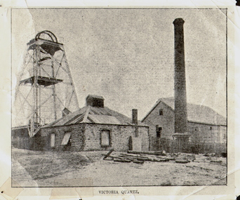
Photograph - VICTORIA QUARTZ - NEW CHUM LINE OF REEF, c.1890
Black and white photograph. Poppet head on LH side, stone building, centre, tall brick chimney, RH side in front of timber building. Inscriptions: on front - 'Victoria Quartz'. On back - typewritten description as follows: 'Situated on the rich Victoria Hill, Ironbark. Steel girders? rams type poppet legs - 60ft high. Vertical winding engines; pair of 24' dia. Winding drums. Made and erected by Roberts & Sons, Bendigo, in 1897. Then one of the best in the state. In 1910 it was the deepest gold mine in the world, having reached a depth of 4,613 ft in the winze. The shaft was then sunk to a depth of 4,588 ft. in an endeavour to reach a depth of 4,870 ft. to effectively work the deepest gold bearing reef in the world. On the night of June 14th, 1910, the mine was flooded out by the rising waters from the deep New Chum mines to the south, all of which had either ceased operations or had returned back to shallow workings. For details of the mine's record, see 'The Historical Guide to Bendigo'. Mine details completed by A Richardson, 29 Harrison Street, Bendigo.place, mining site, victoria quartz