Showing 248 items
matching counties of victoria
-
 Bendigo Historical Society Inc.
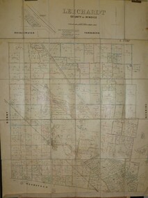
Map - JACK FLYNN COLLECTION: LEICHARDT, 14/03/1`939
Map: Parish of Leichardt, County of Bendigo. Parish plan.Drawn and Reproduced at the Dept, of Lands and Survey, Melbourne, Victoria. 14.3.1939map, bendigo, parish plan, leichardt -
 Bendigo Historical Society Inc.
Map - JACK FLYNN COLLECTION: HAYANMI, March 1953
... , Melbourne, Victoria Map: Parish of Hayanmi, County of Bendigo ...Map: Parish of Hayanmi, County of Bendigo. Parish plan.By Authority: W.M. Houston, Government Printer. Drawn and reproduced at the Dept, of Lands and Survey, Melbourne, Victoriamap, bendigo, parish plan, hayanmi -
 Bendigo Historical Society Inc.
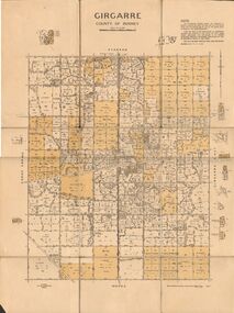
Map - JACK FLYNN COLLECTION: GIRGARRE, 14/10/1943
... Rodney Girgarre Girgarre County of Rodney By Authority, H.E.Daw ...Map: Parish of Girgarre , County of Rodney. Parish plan. Same map as 10100.20 but in poorer condition.By Authority, H.E.Daw, Government printer Melbourne. Drawn and Reproduced at the Dept, of Lands and Survey, Melbourne, Victoriamap, rodney, girgarre, girgarre, county of rodney -
 Bendigo Historical Society Inc.
Map - JACK FLYNN COLLECTION: GIRGARRE, 14/10/1943
Map: Parish of Girgarre. County of Rodney. Parish plan.By Authority, H.E. Daw, Government Printer Melbourne. Drawn and produced at the Dept of Lands and Survey, Melbourne, Victoria. 14.10.1943map, rodney, parish plan, girgarre, county of rodney -
 Bendigo Historical Society Inc.
Map - JACK FLYNN COLLECTION: ECHUCA NORTH, November 1953
Map: Echuca North, County of Rodney. Parish plan.By Authority: W.M. Houston, Government Printer. Drawn and Reproduced at the Dept., of Lands and Survey Melbourne, Victoria. November 1953map, rodney, parish plan, echuca north rodney -
 Bendigo Historical Society Inc.
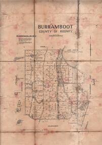
Map - JACK FLYNN COLLECTION: BURRUMBOOT, August 1951
Map: Parish of Burrumboot, County of Rodney. Parish plan.By Authority J.J. Gourley, Government Printer Melbourne. Drawn and Reproduced at the Dept of Lands and Survey, Melbourne, Victoria. August 1951map, rodney, parish plan, burrumboot, rodney -
 Bendigo Historical Society Inc.
Map - JACK FLYNN COLLECTION: ARCHDALE, 15/01/1936
Map: Parish of Archdale, County of Gladstone. Parish plan. The Allotments have been coloured in with pencil.By Authority H.J. Green, Government Printer Melbourne. Drawn and Reproduced at the Dept, of Lands and Survey, Melbourne, Victoria. 15/01/36map, gladstone, parish plan, archdale , gladstone -
 Bendigo Historical Society Inc.
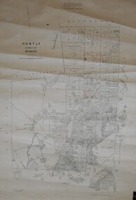
Map - JACK FLYNN COLLECTION: HUNTLY, August 1954
Map: Parish of Huntly, County of Bendigo. Parish plan.By Authority W.M. Houston, Government Printer. Drawn and Reproduced at the Dept, of Lands and Survey, Melbourne, Victoria. August 1954.map, bendigo, parish plan, huntly -
 Bendigo Historical Society Inc.
Map - JACK FLYNN COLLECTION: GOORNONG, August 1953
Map: Township of Goornong, Parish of Goornong, County of Bendigo. Parish plan.By Authority W.M. Houston. Government Printer. Drawn and Reproduced at the Dept., of Lands and Survey, Melbourne, Victoria. August 1953map, bendigo, township, goornong -
 Bendigo Historical Society Inc.
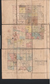
Map - JACK FLYNN COLLECTION: WOODSTOCK, 4/07/1935
Map: Parish of Woodstock, County of Bendigo. Parish plan.By Authority H.J. Green. Govt Printer. Drawn and Reproduced at the Dept of Lands and Survey, Melbourne Victoria. 4.7.35map, bendigo, parish plan, woodstock -
 Bendigo Historical Society Inc.
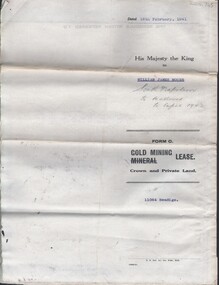
Document - MCCOLL, RANKIN AND STANISTREET COLLECTION: NAPOLEON REEF GOLD MINING CO. N.L, 18 Feb 1941
Document: 4 Page legal document with map of lease area issued to William James Moore of Bendigo, Lease No. 11064 Bendigo, Vol. 325 Fol. 35881 County of Bendigo Parish of Sandhurst, 15 year lease from 18th February 1941, in vacinity of Curnow St, Booth St, Maple St and Rowan Sts, Lease by South Napoleon to be allowed to lapse in 1942, signed by Major General Sir Winston Joseph Dugan Governor of Victoria, William James Moore & witnessed by Walsh, Wardens Clerk Bendigo.organization, business, industrial - mining, mccoll rankin & stanistreet, mining, gold mining, napoleon reef -
 Wangaratta RSL Sub Branch
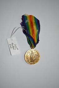
Medal
Medal awarded to Private C T WHYMAN 554269 who served with the 16th London Regiment (County of London). The 16th Battalion was known as the Queen's Westminster Rifles, an Infantry regiment of the British Army formed in 1908 and disbanded in 1938. The Battalion was engaged on the western front between 1914 and 1918. The item was found and no further information is known regarding Private WHYMAN.Round bronze medal - The obverse shows figure of 'Victory' (or 'Victoria') with her left arm extended and holding a palm branch in her right hand.The reverse has the words ‘THE GREAT / WAR FOR / CIVILISATION / 1914-1919' in four lines, all surrounded by a laurel wreath.The ribbon has an iridescent multi-colour scheme and attaches to the medal through a ring suspender The recipient's name, rank, service number and unit is impressed on the edge of the medal. 554269 Pte C T WHYMAN 16 LOND Rww1, 16 london regiment, c t whyman, 1918, victory medal -
 Uniting Church Archives - Synod of Victoria
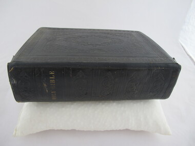
Book - Pulpit bible
Tooled brown leather pulpit bible with gilt text on the spine and gilt edged pages. There is a dedication pasted inside the front.rev david boyd, scots church heidelberg -
 Chiltern Athenaeum Trust
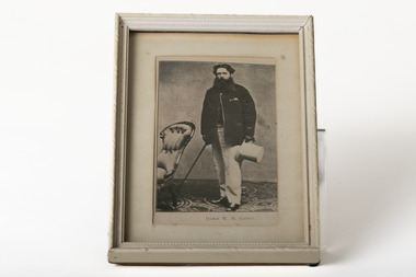
Photograph, JUDGE W. H. GAUNT
This photograph is a copy displayed in the Australian Dictionary of Biography. The original photograph is in the La Trobe Collection in the State Library of Victoria. William Henry Gaunt (1830-1905), judge, was born on 27 July 1830 at Leek, Staffordshire, England, son of John Gaunt, banker, and his wife Mary, née Bakewell. Educated at Leek Grammar School and Whitchurch, Salop, he migrated to Melbourne, and entered the Victorian public service and was rapidly promoted. By March 1854 he was chief clerk at Beechworth, the administrative centre of the Ovens goldfield. In July 1855 the resident warden commended Gaunt as 'a highly valuable public servant' with an intimate knowledge of the district and the 'temper and disposition of the miners'. Appointed sub-warden in the Beechworth district in January 1856 and a Chinese protector in August, he was given control of the extensive Woolshed district. When European miners attacked a party of Chinese at the Buckland River diggings in May 1857 Gaunt was sent to restore order. One of his proclamations, issued in Chinese characters, concluded 'W. H. Gaunt, your protector—tremble and obey!' In June he was appointed a police magistrate and next month was sent to take charge at the Buckland where the Chinese had been expelled from the diggings; the police force assisting him was led by Robert O'Hara Burke. In January 1858 Gaunt was appointed a warden, in November was transferred to Chiltern, north of Beechworth, and in August 1859 was made a commissioner of crown lands. In February 1860 Gaunt was appointed a coroner of Victoria, acting at Indigo, near Chiltern. In April 1865 he was transferred to Beechworth, became visiting justice of the gaol and later moved to Sandhurst. In January 1869 he was appointed returning officer for the mining district of Ballarat and visiting justice of the gaol. He was associated with this area for the rest of his life and won high repute for his integrity. In 1874 he chaired the inaugural meeting of the first Australian competitive swimming club. For years he studied law and was called to the Bar in December 1873. He was one of the many public servants dismissed by Graham Berry on 9 January 1878 (Black Wednesday). After petitioning the Queen in vain over his dismissal he began practice in Ballarat as a barrister. He soon became a leading authority on mining laws; one of the cases in which he was involved was the lengthy inquest on the bodies of the twenty-two miners drowned in the New Australasian mine disaster at Creswick in 1882. He was appointed a temporary judge of the Insolvency Court in 1889 and a County Court judge in 1891. In 1900 he was chairman of the royal commission which considered Metropolitan Board of Works matters, and in 1902 was president of the inquiry into the unification of municipalities in Victoria. In 1860 Gaunt married Elizabeth Mary, the youngest daughter of Frederick Palmer; they had nine children. Of the surviving five sons and two daughters, Ernest Frederick Augustus and Guy Reginald Archer both became admirals and were knighted; Cecil Robert became a lieutenant-colonel, Clive Herbert a government advocate in Rangoon and Mary (Mrs H. L. Miller) one of the first women students to enrol at the University of Melbourne (1881), although she did not complete her degree; she became a successful novelist. Gaunt died on 5 October 1905. An anonymous colleague said: 'I don't think he was ever excelled as a police magistrate, and during the many years he was on the County Court bench he earned the highest regard. His capacities were as unquestioned as his integrity, and more could not be said of any judge'. Select Bibliography Votes and Proceedings (Legislative Assembly, Victoria), 1878, 3, (58) Government Gazette (Victoria), 22 Feb, 15 Aug 1856, 30 June 1857, 5 Jan 1858, 16 Aug 1859, 3 Feb 1860, 7 Mar, 11 Oct 1862, 28 Mar, 4 Apr 1865, 17 May 1867, 9 June 1868, 22, 29 Jan 1869 Ovens and Murray Advertiser, 21 May 1857, 11 Mar 1865 Colonial Secretary's in-letters, goldfields, 25 Mar 1854, 21 July, 18 Nov 1855, 22 Aug 1857 (Public Record Office Victoria) scrapbook and newsclippings (privately held). Related Entries in NCB Sitesview family tree Gaunt, Mary Eliza (daughter)go to ADB entryPhotograph of Judge W. H. Gaunt standing beside chair holding top hat and cane, under glass, in cream frame with cream matte.Printed name underneath: JUDGE W. H. GAUNT -
 Clunes Museum
document - WILL, 1875
COPY OF - THE LAST WILL AND TESTAMENT OF CHARLES GORDON [HOTEL KEEPER] OF THE BOROUGH OF CLUNES IN THE COUNTY OF TALBOT IN THE COLONY OF VICTORIA.COPY OF WILL OF CHARLES GORDON OF CLUNES, VICTORIAlocal history, document, will -
Stawell Historical Society Inc
Map, Department of Crown Lands and Survey Victoria, Allotments in the Township of Banyana. Parish of Burrum Burrum. 1946 / 1971, 1971
... Lands and Survey Victoria 1971. Paper Map of County of Borung ...Richardson River. Avon River JunctionPaper Map of County of BorungReprint of the 1946 edition. Drawn and reproduced at the Department of Crown Lands and Survey Victoria 1971.survey -
Whitehorse Historical Society Inc.
Map, Directory Maps of the County of Bourke, 1892
... Victoria. County of Bourke...also a complete map of the Colony of Victoria, showing all...Directory maps of the County of Bourke, containing all... map of the Colony of Victoria, showing all the Counties ...Directory maps of the County of Bourke, containing all the Parishes ...Directory maps of the County of Bourke, containing all the Parishes ... also a complete map of the Colony of Victoria, showing all the Counties, Parishes, Railways and stations to date, and the Mallee Blocks. Lithographed by G.S.B. Bonney for the Victorian Shire Map Company. Scale: 40 chains to the inch.Directory maps of the County of Bourke, containing all the Parishes ...maps, victoria. county of bourke, t.r.b. morton & son -
 Ballarat Heritage Services
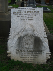
Photograph - Colour, Clare Gervasoni, Kavanagh Memorial , Warrnambool Cemetery, 27/07/2009
Daniel and Denis Kavanagh were brothers from County Carlow, Ireland. Denis Kavanagh died at Garvoc, Victoria. Kavanagh memorial in the Warrnambool Cemetery. warrnambool cemetery, denis kavanagh, daniel kavanagh, county carlow, ireland, garvoc -
Unions Ballarat
Peter Lalor Lithograph, n/d
... . Born - Tennikill, Queen's County, Ireland, 1827. Died... of. Eureka Stockade (Ballarat), politics and government (Victoria ...Peter Lalor rose to fame for his leading role in the Eureka Rebellion at Ballarat in 1854. He is the only outlaw to make it into parliament. The siege of Eureka culminated in November and December 1854 arising as the result of disagreement between disaffected gold miners (led by Peter Lalor) and colonial forces about compulsory mining licences. This lithograph is rare - the only one we are aware of.Eureka Stockade (Ballarat), politics and government (Victoria, Australia).Lithograph - sepia. Picture of Peter Lalor in Legislative Assembly speaker's regalia."The late Hon Peter Lalor, Ex-Speaker of the Legislative Assembly and leader of the Memorable Eureka Insurrection of 1854. Born - Tennikill, Queen's County, Ireland, 1827. Died - Melbourne, Victoria, 1889. Aged 62 years."btlc, ballarat trades hall, ballarat trades and labour council, eureka stockade, lalor, peter, history - ballarat, politics and government -
 Heytesbury District Historical Society Inc.
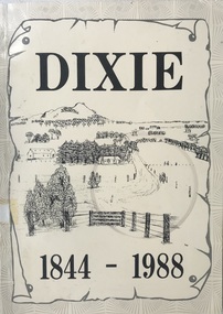
Book, Dixie 1844-1988
Paperback with black and white photographs, large map of County of Heytesbury inside back cover. An account of the settlement of the area known as Dixie in the County of Heytesbury, including pioneers, soldier settlers, the school, churches, sports club etc. during the period from 1844 to 1988. heytesbury shire - history, early settlement - south west victoria, dixie -
 Bendigo Historical Society Inc.
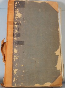
Legal record - Land Register
Land register for duration 1924 to 1951 (!!). Register contains plans of Land sales for a broad area of Central Victorian Parish / Counties. Register has a stiff blue card cover originally bound with light brown leather spine and corners, presently in a dire condition with cover damaged and loose; plans also folded and damaged. Plans inserted as drawn plans within the register, later plans are included on tracing, paper and linen - in various degrees of condition / damage.land register, central victoria -
Bendigo Historical Society Inc.
Map - NERRING : COUNTY OF BENDIGO, August 1952
Map. Nerring, County of Bendigo, Leichardt, Marong, Sandhurst, Huntly, Neilborough, Yarraberb. Drawn and Reproduced at the Department of Lands and Survey, Melbourne, Victoria, August 1952, Price 2/-.( number 409 in Map Cupboard 1).J.J. Gourley, Government Printer, Melbourne.bendigo, hospital -
 Bayside Gallery - Bayside City Council Art & Heritage Collection
Map, Department of Crown Lands and Survey et al, Moorabbin, County of Bourke, Government Roads, 1920
The cadastral map of the Parish of Moorabbin in Victoria (L.6104) shows parish boundaries and land ownership 1920 when Sandringham was a Town. The government roads have been coloured in red pencil.moorabbin, county of bourke, map, plan, land subdivision, land titles, foreshores, hampton, beaumaris, highett, cheltenham, department of lands and survey, land owners, cartographic material, brighton, sandringham, town of sandringham, government roads -
 Bayside Gallery - Bayside City Council Art & Heritage Collection
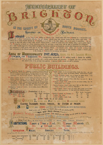
Certificate - Illuminated certificate, Brighton Municipal Certificate, 1861
bayside city council, borough of brighton, illuminated, certificate, population, public buildings, surveyor, council, borough, county of bourke, census, colony of victoria -
 Bayside Gallery - Bayside City Council Art & Heritage Collection
Map, Department of Crown Lands and Survey, Moorabbin, County of Bourke, c. 1918
The cadastral map of the Parish of Moorabbin in Victoria (L.6104) shows parish boundaries and land ownership c. 1918 when Sandringham was a Borough.moorabbin, county of bourke, map, plan, land subdivision, land titles, foreshores, sndringham, hampton, beaumaris, highett, cheltenham, department of lands and survey, land owners, cartographic material, borough of sandringham, brighton -
 Bendigo Historical Society Inc.
Photograph - Rocky Vale Villa, April 2016
The Beebe name was well-known in Bendigo in the last quarter of the 19th and the early part of the 20th centuries. From 1875, William Beebe senior, monumental mason, occupied a site in the centre on the city, in Mitchell Street opposite King Street. Death was more part of life in those days, and the Beebes were there to provide the burial monuments. Later, he took his sons into the business, which grew as Beebe and Son. Many examples of their work can be found in the local cemeteries. William Beebe senior (1830-1891) was born in Rutland, the smallest English county in 1830, to stonemason Chamberlain Beebe and Susannah Clements. William emigrated to Victoria in 1854 and after engaging on unknown works in Port Fairy, Dunkeld, and Melbourne arrived in Bendigo. His obituary records that he commenced work here on the site of the Bank of Australasia (opposite the Shamrock Hotel), which would have been no later than 1856. He took up a 13 acre selection on the site of Rocky Vale Villa in 1864 and continued to select or purchase further parcels of adjoining land until he owned some 150 acres, much of it unfit for cultivation. He was a keen gardener and had a garden and orchard around the house. William took over 20 years to build the two-story sandstone and granite house "Rocky Vale Villa". The house was constructed from sandstone sourced "from an adjacent ridge of rocks" (Bendigo Advertiser 28/9/1891). Granite from Harcourt was used for lintels and quoins. Not long before he died, William was still adding to the house. In the Codicil to his will, he states that "I have just built and completed two additional rooms to my Dwelling house situe at Inglewood Road aforesaid" (dated 19/9/1891). William died one week later on the 26th September 1891.Photographs of a field trip to Rocky Vale Villa, 7 Wicks Road, Maiden Gully, Bendigo by the Bendigo Historical Society.history, bendigo, rocky vale villa maiden gully, william beebe stonemason bendigo -
 Bendigo Historical Society Inc.
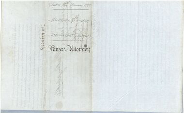
Legal record - Power of Attorney, 18/02/1862
Captain Mackenzie Luckie was born in 1821. From 1853 he commanded eight ships. He died on board the Michael Angelo off the coast of New Zealand in February 1875. After the ship arrived in Nelson, The Argus (Melbourne) reported on 12 February 1875 that Captain Luckie was found dead in his cabin, from heart disease. His appointed Attorney Mr George William Knight selected land in Sunbury in 1860 and then arrived in Bendigo on 2 April 1870. For more information about George William Knight see https://trove.nla.gov.au/newspaper/article/227853797?searchTerm=george%20william%20knightCaptain McKenzie Luckie a. Document appointing George William Knight of Sunbury or elsewhere in the Colony of Victoria as a lawful attorney to act for Mackenzie Luckie of 15 Tredegar Square, Bow in the County of Middlesex (now London), Master Mariner. Dated 18 February 1862. Witnessed by William Charles White. Five page document - two blue flimsy sheets, one light card sheet and two grey flimsy sheets. b. Transcript from The Age (Melbourne) 27 November 1937. The letter from H. Daniel, Monte Video, South America, is responding to an earlier letter from the grand daughter of Captain Mackenzie Luckie. It includes a record of the career of Captain Luckie from 1853. captain mackenzie luckie, master mariner -
 Kew Historical Society Inc
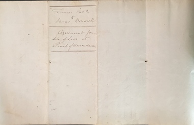
Legal record (Item), Thomas Judd to James Bonwick: Agreement for Sale of Land at Parish of Boroondara, 1853, 28/02/1853
James Bonwick (1817-1906), the Victorian educator and historian, acquired land in Kew on which to establish a home and school in 1853, not 1854 as more commonly stated. Bonwick returned to England in 1859 for a period, later returning to Melbourne and settling in St Kilda. He was the author of a number of histories and an official transcriber of Government records.This newly acquired document, from a former owner of 'Parkhill' (20 Hillcrest Avenue, Kew), is of statewide importance as it is the original copy of the agreement made between Thomas Judd of Parkhill and James Bonwick in 1853 for the purchase of land in Kew. Both Thomas Judd and James Bonwick were significant pioneers of Victoria.TRANSCRIPT [TITLE] Thomas Judd to James Bonwick Agreement for Sale of Land at Parish of Boroondara [PAGE 1] Articles of agreement made and entered into this the Twentyth eighth day of February One thousand Eight Hundred and fifty three Between Thomas Judd of Melbourne in the Colony of Victoria Gentleman of the one part and James Bonwick of Melbourne in the Colony of Victoria Gentleman of the other part whereby the said Thomas Judd agrees to sell unto the said James Bonwick who hereby agrees to purchase a piece or parcel of land containing two and half acres be the land more or less part of Portion Number Eighty five of the Parish of Boroondara in the County of Bourke commencing at a point on the Northern boundary line of the said Portion Seventeen Chains fifty links East from the North West angle of the same and bounded on the East by other part of said Portion in a line bearing South Eight Hundred and sixty two feet on the South by other part of said Portion Eighty five in a line bearing West one Hundred twenty six and half feet on the West by other part of said Portion Eighty five in a line bearing North Eight Hundred and Sixty two feet on the North by the Northern boundary line of the said Portion Eighty five in a line bearing East one Hundred twenty six and half feet to the commencing point at or for the price or sum of one [PAGE 2] One Hundred Pounds to be paid and payable in the manner hereinafter mentioned that is to say the Sum of Thirty pounds to be paid on the day of the date hereof and the sum of forty pounds by the acceptance of the said James Bonwick for that sum at three months bearing interest thereon after the rate of Eight Pounds per centum per annum and the Sum of Thirty pounds by the acceptance of the said James Bonwick for that sum after Six months with interest thereon after the rate of Eight pounds per centum per annum It is furthermore agreed that the said James Bonwick shall have access by a right of way fifteen feet wide reserved by the said Thomas Judd to the Government Road being the Southern Boundary of Portion Eighty five. That in case default shall be made in the payment of any of any of the Acceptances above mentioned the amount paid shall be actually forfeited to the said Thomas Judd who shall be at liberty to resell the premises. That upon payment of the whole amount of the purchase money the said Thomas Judd shall execute a conveyance of the premises to the said James Bonwick Such conveyance to be prepared by and at the expense of the said James Bonwick who - [PAGE 3] who shall also pay the cost of any attested copies he may require. ---- As witness the hands of the said parties this the twenty first day of February one thousand Eight Hundred and fifty Three. ----- [Signature] T. Judd [Signature] Jas Bonwick Witness [Signature illegible] £ Received Cash on account of the above 30.0.0 Thirty Pounds Bill at three Months with interest 42.4.0 Bill at Six Months with interest 31.4.0 _____ £103.8.0 _____ [Signature] T. Judd [Signature] Jas Bonwick ------------ Transcribed David White 25/08/2020 james bonwick, thomas judd, land titles - kew (vic), pioneers - kew - victoria -
 Kew Historical Society Inc
Plan - Framed Subdivision Plan (copy), F Price, Plan of Mr William Derrick's Land, Kew being Subdivision of Part of Section 86, Parish of Boroondara, County of Bourke, 1872, 1872
William Derrick was an early landowner in Kew, and with James Venn Morgan and James Dannock the purchaser of the parcel of land bounded by Cotham Road, High Street and Mary Street. Derrick Street in Kew is named after him.Map mounted under perspex. ‘Plan of Mr Willia Derrick's Land, Kew being Subdivision of Part of Section 86, Parish of Boroondara, County of Bourke’. This is a copy of the plan held in the State Library of Victoria.kew subdivision plan, john derrick, subdivision plans -- kew (vic.) -
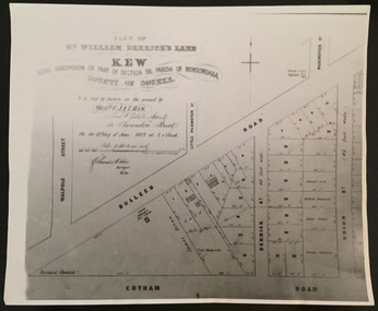 Kew Historical Society Inc
Print - Subdivision Plan, F Price, Plan of Mr William Derrick's Land, Kew being Subdivision of Part of Section 86, Parish of Boroondara, County of Bourke, 1872, 1872 [Original]
This work forms part of the collection assembled by the historian Dorothy Rogers, that was donated to the Kew Historical Society by her son John Rogers in 2015. The manuscripts, photographs, maps, and documents were sourced by her from both family and local collections or produced as references for her print publications. Many were directly used by Rogers in writing ‘Lovely Old Homes of Kew’ (1961) and 'A History of Kew' (1973), or the numerous articles on local history that she produced for suburban newspapers. Most of the photographs in the collection include detailed annotations in her hand.The Rogers Collection provides a comprehensive insight into the working habits of a historian in the 1960s and 1970s. Together it forms the largest privately-donated collection within the archives of the Kew Historical Society.A photographic reproduction of a plan in the Vale Collection of the State Library of Victoria showing William Derricks land in the area bordered by Bulleen Road (High Street); Cotham Road and Union Street. The plan dates from 1872.william derrick, subdivision plans -- kew (vic.)