Showing 3768 items
matching court street
-
 Kew Historical Society Inc
Plan - Subdivision Plan, Churchill Park Estate, Templestowe
... Court, Potter Court, Thompsons Road, Richards Street... Court, Potter Court, Thompsons Road, Richards Street ...Historic subdivision plan of the Churchill Park Estate in Templestowe.Undated subdivision plan advertising the Churchill Park Estate inTemplestowe. Streets identified in the plan include: Corroboree Place, Astley Street, Jeffrey Street, Airds Road, Dove Court, Potter Court, Thompsons Road, Richards Street, and Birchwood Avenue.Annotations in ink on the plan by agentsubdivision plans - templestowe (vic), churchill park estate - templestowe (vic) -
 Ringwood and District Historical Society
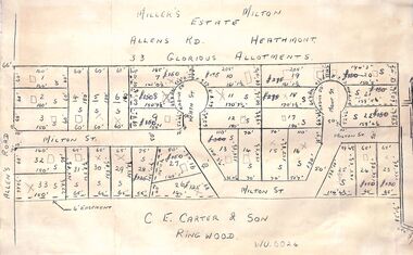
Pamphlet - Land Sales Brochure, Miller's Estate , Heathmont - circa 1950s
... of the Miller's Estate on Allens Road, Milton Street, Heath Court and Mont... allotments of the Miller's Estate on Allens Road, Milton Street ...Hand-drawn land subdivision map with 33 allotments of the Miller's Estate on Allens Road, Milton Street, Heath Court and Mont Court, Heathmont. Sold by CE Carter & Son, Ringwood WU6024. (2 copies, one on blue cardboard backing.)LP28038 P/R 1954 -
 Bendigo Military Museum
Souvenir - ADVERTISING CARD, The Fitzroy Tavern, C. WW2
... Windmill Street, Tottenham Court Road, London W.I. During and after... Windmill Street, Tottenham Court Road, London W.I. During and after ...Advertising card issued to visitors to the Fitzroy Tavern Windmill Street, Tottenham Court Road, London W.I. During and after WW2. Part of the Frederick Gardner Davey DFC RAAF collection. Refer Cat No 3536P for his service record..1) & .2) Rectangular cream paper with black type on front, type on front contains the business name, address and phone number. .1) On the back is a two verse poem. .2) on the back is a seven line ditty with an accompanying black silhouette picture of a man next to a car.souvenir, business card, tavern -
 Grey Street Primary School, Traralgon
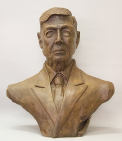
Wax model, Sir Macfarlane Burnet, About 1999
... the Traralgon Court House in Franklin Street and was commissioned... outside the Traralgon Court House in Franklin Street ...Wax mould from which bronze bust of Sir Macfarlane Burnet was cast. The bronze bust is located on a plinth outside the Traralgon Court House in Franklin Street and was commissioned by Latrobe City to celebrate the centenary of Sir Macfarlane Burnet's birth.Mac Burnet attended Traralgon State School, and went on to become Director of the Walter and Eliza Hall Institute of Medical Research and share the Nobel Prize for Medicine with Peter Medawar of London University.Wax model by artist Glen Davies -
 Stawell Historical Society Inc
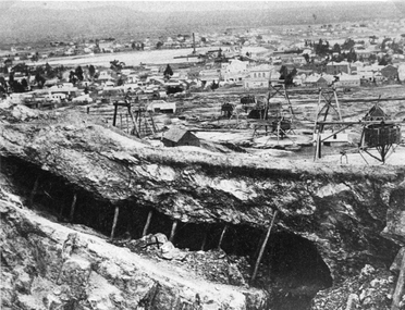
Photograph, Panorama of Mining Scene from Big Hill with the Open cut in foreground
... Court House in Patrick Street. The flat area in distance is St... with support timbers. Whims and poppet heads. Shows back of New Court ...Mining Scene from Big Hill. Open cut in fore ground with support timbers. Whims and poppet heads. Shows back of New Court House in Patrick Street. The flat area in distance is St Georges Crushing Battery settling Dam.Open Cut with supporting timbers in foreground, Various poppet Heads at centre of image. Wimmera Crushing Mill settling dam in distance. Rear of new Court House visiblestawell mining -
 Ringwood and District Historical Society
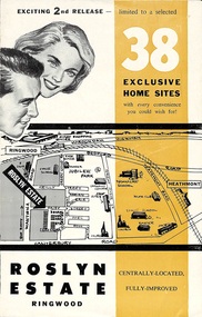
Flyer, Land Sale Brochure - Roslyn Estate, Ringwood, Vic. - circa 1960s
... Subdivision includes Daisy Street, Vale Street, Joan Court..., Vale Street, Joan Court, Christine Court, and Westmore Drive ...Land sale advertisement for 2nd release of residential sites with area map, layout of the estate, terms of sale, and summary of local facilities and services.Subdivision includes Daisy Street, Vale Street, Joan Court, Christine Court, and Westmore Drive. (Agent) Heathmont Estate Agency, 103 Canterbury Road, Heathmont. (Phone) WU7808-9. Brochure also includes map with streets marked as "Sold" - Reilly Street, Adrian Court, Daisy Street, Jarma Road, Joel Court, and Ross Court, with comment that "all home sites in the first release have already been sold, and most built on." -
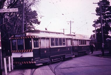 Ballarat Tramway Museum
Slide - 35mm slide/s - set of 7, Noel Simons, 1970's
... and has "Stafford Court" street sign mounted on it. 1175.2... tram stop sign and has "Stafford Court" street sign mounted ...Set of 7 transparencies taken undated (appear to be 1970 or 71) on PAKON mounts. Also possibly copy slides as quality is poorish. 1175.1 - No. 27 has derailed at Depot, across Wendouree Parade, and No. 33 appears to be about to try and tow it back on. Wendouree Parade totally blocked. Adjacent pole has tram stop sign and has "Stafford Court" street sign mounted on it. 1175.2 - No. 43 at corner of Drummond St. South and Dana Street, with destination Lydiard St. North. 1175.3 - No. 42 (Mt Pleasant) and 21 (Gardens via Sturt St. West) crossing at Gardens Loop. 1175.4 - No. 42 bound for Lydiard St. Nth at intersection with Macarthur St. Shows the retaining wall for the cutting on the east side of Lydiard St. Nth. 1175.5 - No. 43 at corner of Lydiard St and Sturt St., at city terminus showing "Special" and tram 35 adjacent to Post Office in Lydiard St. Nth. Photo shows the small tram stop pole at this location and Post Office building. 1175.6 - No. 39 and 26 and 27 at the Mt Pleasant terminus. Near closure as a bus stop sign has been positioned on the west side of the road. No. 39 showing destination of "Gardens via Sturt St. West" 1175.7 - Nos 21 and 34 crossing at the Grant St. loop in Barkly St. 21 has destination of Mt Pleasant, while 34, - Gardens via Sturt St. West"All information on typed small white labels, on the top of the slides using black ink. 1175.1 - "27 derailed and 33 at depot" 1175.2 - "43 at cnr Drummond & Dana Sts" 1175.3 - "21 and 42 Gardens Terminus" 1175.4 - "42 at cnr Macarthur & Lydiard" 1175.5 - "43 & 35 at Post Office" 1175.6 - "39, 26 and 27 at Mt Pleasant" 1175.7 - "21 & 34 at Grant St"tramways, trams, wendouree parade, depot, accidents, derailments, drummond st. sth, gardens loop, post office, mt pleasant, grant st., tram 21, tram 26, tram 27, tram 33, tram 35, tram 42, tram 43 -
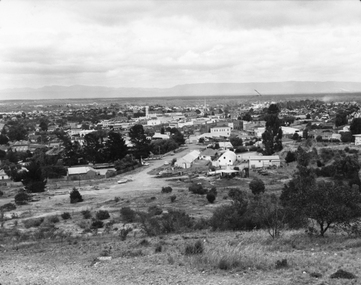 Stawell Historical Society Inc
Photograph, Panorama of Stawell from Big Hill c 1960's
... Fisher Street. Stawell Court House visible. Top end of Main... Fisher Street. Stawell Court House visible. Top end of Main ...Panorama View of Stawell from Big Hill with Grampians in Background. c 1960 looking Down top end of Sloane Street across Fisher Street. Stawell Court House visible. Top end of Main Street Visible corner of Patrick and Main StreetBlack & White photo of Stawell from Big Hill. View showing Upper Sloan St with Fisher St crossing to the right. stawell, panorama, streetscape -
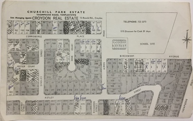 Kew Historical Society Inc
Plan - Subdivision Plan, Churchill Park Estate, Templestowe
... Court, Potter Court, Thompsons Road, Richards Street... Court, Potter Court, Thompsons Road, Richards Street ...Historic subdivision plan of the Churchill Park Estate in Templestowe.Undated subdivision plan advertising the Churchill Park Estate inTemplestowe. Streets identified in the plan include: Corroboree Place, Astley Street, Jeffrey Street, Airds Road, Dove Court, Potter Court, Thompsons Road, Richards Street, and Birchwood Avenue. This record includes a copy of the price list.Annotations in ink on the plan by agentsubdivision plans - templestowe (vic), churchill park estate - templestowe (vic) -
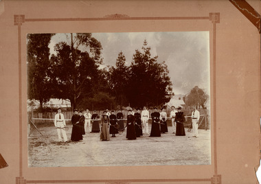 Beaufort Historical Society
Photograph - Beaufort Tennis Club
... Tennis club established 1890. Courts at Willoby Street...Tennis club established 1890. Courts at Willoby Street ...Tennis club established 1890. Courts at Willoby Street ( currently site of Council depot). Persons identified: ( L to R) Charles Troy, Violet Troy, F Minchin, A Tromph, Miss McRae, Mrs Sinclair, J McKeich, Miss N Troy, Mrs Welsh, Miss Martha Nickells, ?, Miss E Nickells, Fred Troy, Miss Jackson, Miss Jackson, B Thompson, Miss Stewart, Robert SinclairEarly sporting club in BeaufortBlack & White photograph mounted on cardNilbeaufort, beafort tennis club -
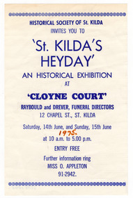 St Kilda Historical Society
Ephemera - Flyer, 'St. Kilda's Heyday' An Historical Exhibition at 'Cloyne Court', 1975
... by the Historical Society of St. Kilda at 'Cloyne Court' 12 Chapel Street St... by the Historical Society of St. Kilda at 'Cloyne Court' 12 Chapel Street St ...Flyer for a free exhibition about St Kilda, presented by the Historical Society of St. Kilda at 'Cloyne Court' 12 Chapel Street St Kilda, on 14-15 June 1975. Cloyne was constructed in 1887 for Sir John Madden, a Melbourne barrister, who became Chief Justice in 1893 and Lieutenant-Governor in 1899. It was named after his birthplace in County Cork, Ireland. He and Lady Madden lived at Cloyne until 1912.White paper, discoloured with age, printed in blue on one sideHandwritten in brown felt pen: '1975'st kilda historical society, cloyne court -
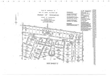 Ringwood and District Historical Society
Document - Subdivision Plan, Part of Crown Allotment 32B Parish of Ringwood, County of Mornington Vol 6051 Fol 111 - LP26857
... Avenue, Maple Court, and Heathwood Street, Ringwood East, Vic... Avenue, Maple Court, and Heathwood Street, Ringwood East, Vic ...LANDATA Land Victoria 2-sheet plan printout dated 9/11/1953.Sheet 1 includes Lynwood Avenue, Isabel Avenue, Braewood Avenue, Maple Court, and Heathwood Street, Ringwood East, Vic. Sheet 2 includes Braewood Avenue, Rotherwood Avenue, and Heathwood Street, Ringwood East, Vic. Additional markings include LP46598, CP173330, LP86847, LP213448, LP217511, LP207217, LP56241. -
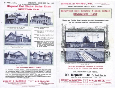 Ringwood and District Historical Society
Flyer, Land Sale Auction Brochure, Electric Station Estate, Ringwood East, Vic. - 1924
... Court and French Street), and Dublin Road. (Agents) Knight..., Howship Avenue (later Howship Court and French Street), and Dublin ...Folded double-sided advertisement for Ringwood East Electric Station Estate subdivisional sale of retail and residential allotments by public auction on Saturday, 1 November, 1924, with local photographs, terms of sale, and summary of subdivision features and local facilities. Subdivision includes Railway Parade (later Patterson Street, Rosedale Crescent, Federal Road, Howship Avenue (later Howship Court and French Street), and Dublin Road. (Agents) Knight & Harwood, 315 Collins Street, Melbourne, Phone Central 10615, 10616, in conjunction with J.B. McAlpin, Opposite Railway Station, Ringwood, Phone Ringwood 7. -
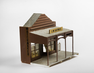 Port Fairy Historical Society Museum and Archives
Mixed media - Model, J.W.Haymes, Early 1970's
... the Historical Society moved to the Court House in Gipps Street Port... to the Court House in Gipps Street Port Fairy This Panorama was part ...This model was part of a panorama consisting of 11 pieces designed from drawings in 1892 Almanac from the Port Fairy Gazette. The Panorama was used in a historical display in the historical society rooms in Bank Street from the late 1970's to 1992 when the Historical Society moved to the Court House in Gipps Street Port FairyThis Panorama was part of an eleven piece Panorama of the Streetscape of Port Fairy in 1982. Made by a local resident.Small handmade model of a shop front from the 1892 almanac.J.W.Haymes. Watchmaker panorama, model, j w haymes, watchmaker, bank street -
 Port Melbourne Historical & Preservation Society
Photograph - Civic structures, Port Melbourne, Ron LAING, Ron Laing, 1986 - 1999
... , Metropolitan Fire Station, Police quarters, Police Station and Court... by the photographer. Built Environment - Civic Ron LAING Nott Street State ...Part of Ron Laing's collection of photographs recording Port Melbourne over a thirteen year period. Donated to the PMH&PS by the photographer.A set of 37 colour photographs of Port Melbourne civic stuctures, 1990s, including the Town Hall, Liardet Community Centre, Freemasons' Hall, RSL Club (Excelsior Hall), old fire station, 1910 Post Office, 1860 Post Office and Naval Drill Hall, Metropolitan Fire Station, Police quarters, Police Station and Court House, Nott Street State School, Graham Street State School, St Joseph's Primary School and Rotunda in Beach Streetbuilt environment - civic, ron laing, nott street state school, graham street state school, port melbourne primary school, port melbourne town hall, liardet community centre, excelsior hall, freemasons hall, fire station, post office, naval drill hall, police station, st josephs catholic primary school, band rotunda -
 Ringwood and District Historical Society
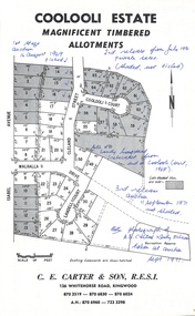
Document - Folder, Coolooli Estate Subdivision, Ringwood East, Vic. - Four Releases 1969-1975
... , Isabel Avenue, Walhalla Drive, Cleland Street, Landell Court..., Cleland Street, Landell Court, Byways Drive, Heathwood Street ...Collection of Subdivision Plans, Land Sale flyers, Auction notices, and Real Estate Agent's notes for Coolooli Estate, Ringwood East, Victoria. Subdivision includes Coolooli Court, Isabel Avenue, Walhalla Drive, Cleland Street, Landell Court, Byways Drive, Heathwood Street and Hume Street, released over four stages - First Stage auction 16 August 1969, Second Release private sales from July 1970, Third Release Auction 11 September 1971, Final Release auction June 21st 1975. Agents - C.E. Carter & Son, 126 Whitehorse Road, Ringwood until moving to 122 Whitehorse Road in 1973 - Tel. 870 6024, 870 6830, 870 2519, A.H. 723 3298, 870 6960. Digitised copy of photograph - A.B. Carter and Andy McLean at Coolooli Estate auction, 11 September, 1971. -
 Eltham District Historical Society Inc
Photograph - Aerial Photograph, Landata, Eltham, Nov. 1931
... Centred over present-day Laleham Court between Arthur... Webster Collection Arthur Street Hartland Way Laleham Court ...Centred over present-day Laleham Court between Arthur Street and Hartland Way, Eltham Historic Aerial Imagery Source: Landata.vic.gov.au Aerial Photo Details: Project No :1931 Project : MALDON PRISON Run : 20 Frame : 3136 Date : 11/1931 Film Type : B/W Camera : F8 Flying Height : 11000 Scale : 18860 Film Number : 60 GDA2020 : 37°42'56"S, 145°09'33"E MGA2020 : 337759, 5824139 (55) Melways : 22 B5 (ed. 42) aerial photo, eltham, neil webster collection, arthur street, hartland way, laleham court -
 City of Greater Bendigo - Civic Collection
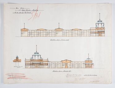
Work on paper - Architectural Drawing, City of Bendigo, New Baths at Upper Reserve Bendigo for the Bendigo City Council, 18th November 1912
... the men's bathing area adjacent to the still existing tennis courts... adjacent to the still existing tennis courts on Barnard Street ...The 'New' City of Bendigo baths also known as 'The Baths' were opened on 26th February,1913 at a cost of £2000. These baths made use of an existing dam and had men only and ladies bathing areas as well as a 'paddling paddock' for young children. This set of plans is for the Men's Bathing shed which serviced the men's bathing area adjacent to the still existing tennis courts on Barnard Street. In 1958 the Municipal Baths were replaced by an Olympic Pool and £17,000 was raised by public subscription towards this pool’s construction. Ink, pen, pencil and watercolour architectural drawing for the proposed new baths at the Upper Reserve on Barnard Street, Bendigo.New baths / at Upper Reserve Bendigo / for the Bendigo City Council / Elevation facing tennis courts / Elevation of Terminals at A, A, / Elevation facing Barnard Street / This is one of the drawings /referred to in my contract/ dated 18th November 1912 / Signed Robert J Rogers / (unknown) / Mayor Jas Semmensbendigo swimming club, rosalind park, upper reserve bendigo, faith leech memorial swimming pool, bendigo baths, city of greater bendigo community groups -
 Kew Historical Society Inc
Plan - Subdivision Plan, J R Mathers & McMillan, Clutha Subdivision, 1940
... Court and Younger Street were created as part of the subdivision... and Edgecombe Streets. Two new streets, Mackie Court and Younger Street ...Pru Sanderson, in her groundbreaking ‘City of Kew Urban Conservation Study : Volume 2 - Development History’ (1988), summarised the periods of urban development and subdivisions of land in Kew. The periods that she identified included 1845-1880, 1880-1893, 1893-1921, 1921-1933, 1933-1943, and Post-War Development. These periods were selected as they represented periods of rapid growth or decline in urban development. An obvious starting point for Sanderson’s groupings involved population growth and the associated economic cycles. These cycles also highlighted urban expansion onto land that was predominantly rural, although in other cases it represented the decline and breakup of large estates. A number of the plans in the Kew Historical Society’s collection can also be found in other collections, such as those of the State Library of Victoria and the Boroondara Library Service. A number are however unique to the collection.The Kew Historical Society collection includes almost 100 subdivision plans pertaining to suburbs of the City of Melbourne. Most of these are of Kew, Kew East or Studley Park, although a smaller number are plans of Camberwell, Deepdene, Balwyn and Hawthorn. It is believed that the majority of the plans were gifted to the Society by persons connected with the real estate firm - J. R. Mathers and McMillan, 136 Cotham Road, Kew. The Plans in the collection are rarely in pristine form, being working plans on which the agent would write notes and record lots sold and the prices of these. The subdivision plans are historically significant examples of the growth of urban Melbourne from the beginning of the 20th Century up until the 1980s. A number of the plans are double-sided and often include a photograph on the reverse. A number of the latter are by noted photographers such as J.E. Barnes.The subdivision plan for the Clutha Subdivision is one of the largest in the Society’s collection. The plan includes a map of the proposed allotments, photographic views to the north and south, and information about the kinds of buildings that could be constructed on the allotments. The subdivision was bounded by Studley Park Road, and Carson, Stevenson and Edgecombe Streets. Two new streets, Mackie Court and Younger Street were created as part of the subdivision. The subdivision took its name from ‘Clutha’, the home of John Carson, who was to become Mayor of Kew in 1863. A Report to the City of Boroondara outlined how: ‘The Clutha estate was progressively developed from 1940, with new houses under construction on the Studley Park Road, Carson and Edgecombe Street frontages by 1941. By 1943, directory listings were available for all addresses with the exception of Mackie Court. Building ceased after the government’s prohibition on civilian building was enforced from 1942, with little change in listings until the 1950s when the remainder of the subdivision was developed’."H"subdivisions - kew - studley park, clutha subdivision, studley park road -
 Stawell Historical Society Inc
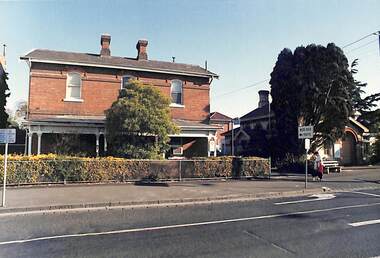
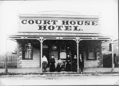
Photograph, Court House Hotel in Patrick Street Stawell
... this hotel opposite the Court House in Patrick Street in 1879... this hotel opposite the Court House in Patrick Street in 1879 ...Court House Hotel. Patrick St. Stawell. Thomas Crerar built this hotel opposite the Court House in Patrick Street in 1879. The first license was from that year until 1884 by Elizabeth Cowman. The final license was held by Margery Bonetia Phillips from 1903 to 1909. It was closed by the Licensing Board 3/5/1909. Cowman Bros being the Owners.Hotel Building with five women and one man on verandah.stawell, hotels -
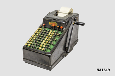 Whitehorse Historical Society Inc.
Equipment - Adding Machine
... . Ltd, Capel Court, 375-377 Collins Street Melbourne...'Chartres Pty Ltd/Capel Court/375-377 Collins Street... by Chartres Pty. Ltd, Capel Court, 375-377 Collins Street Melbourne ...Built on a cast iron base the machine is designed for Sterling currency with a full-keyboard that has five decimal columns for pounds, three columns for shilling and pence, one column for the 10 and 11 pence keys and three farthing (1/4 penny) keys. The machine was imported and distributed by Chartres Pty. Ltd, Capel Court, 375-377 Collins Street MelbourneHand operated comptometer or adding machine with side handle. Sterling currency with full-keyboard with columns for Pounds Shillings and Pence'Chartres Pty Ltd/Capel Court/375-377 Collins Street Melbourne/23359'commerce, office equipment / stationery, bookkeeping -
 Lorne Historical Society
Pamphlet - Tourist pamphlet Lorne, Lorne Victoria Australia
... attractions,; the Main Street, tennis courts, Erskine River, walking... of Lorne attractions,; the Main Street, tennis courts, Erskine ...Victorian Railways printed a series of brochures publicizing holiday destinations.A folded paper souvenir pamphlet. The cover is a colored picture of Lorne from Scotsman’s Hill with two bathing suited young women in the foreground, and a blurb extolling the virtues of Lorne. On the back is a red, yellow and blue map of Lorne and district. Inside are eight black and white photographs of Lorne attractions,; the Main Street, tennis courts, Erskine River, walking tracks and the George River with the phrase ,” The resort that embraces everything for the perfect holiday.”souvenirs, pamphlets, victorian railways, -
 Kilmore Historical Society
Photograph, Sydney Street Kilmore, 1880's
... 2.5x1.5 inch black and white photograph of 1 Powlett street... Powlett street, the Court House Hotel, former colonial bank ...2.5x1.5 inch black and white photograph of 1 Powlett street, the Court House Hotel, former colonial bank of Australasia. Corner of Powlett Street and Lancefield Road. Copy printed on card stock. Two story light coloured rendered building. The intersection of Lancefield Road, Powlett Street, Sydney Street and (modern day) Skehan Place. With a view straight down Sydney Street. One figure crossing the road.Writing on the back: PHO-00004hotels, historical towns -
![Scene on the Yarra, near Rourke's Bridge / [by] Nicholas Caire, circa 1876](/media/collectors/550653872162f11fb04854aa/items/5777571cd0cdd10a5c191a9c/item-media/57775788d0cdd10a5c193e0d/item-fit-380x285.jpg) Kew Historical Society Inc
Kew Historical Society IncPhotograph, Anglo-Australasian Photographic Company, Scene on the Yarra, near Rourke's Bridge, c. 1876
... l.c.r.: 10 Temple Court, Collins Street West..... printed in ink on support reverse l.c.r.: 10 Temple Court, Collins ...Nicholas Caire was born on Guernsey in the Channel Islands in 1837. He arrived in Adelaide with his parents in about 1860. In 1867, following photographic journeys in Gippsland, he opened a studio in Adelaide. From 1870 to 1876 he lived and worked in Talbot in Central Victoria. In 1876 he purchased T. F. Chuck's studios in the Royal Arcade Melbourne. In 1885, following the introduction of dry plate photography, he began a series of landscape series, which were commercially successful. As a photographer, he travelled extensively through Victoria, photographing places few of his contemporaries had previously seen. He died in 1918. Reference: Jack Cato, 'Caire, Nicholas John (1837–1918)', Australian Dictionary of BiographyAn original, rare photograph from the series 'Views of Victoria: General Series' by the photographer, Nicholas Caire (1837-1918). The series of 60 photographs that comprise the series was issued c. 1876 and reinforced a neo-Romantic view of the Australian landscape to which a growing nationalist movement would respond. Nicholas Caire was active as a photographer in Australia from 1858 until his death in 1918. His vision of the Australian bush and pioneer life had a counterpart in the works of Henry Lawson and other nationalist poets, authors and painters.Albumen silver photograph mounted on boardprinted in ink on support l.c.: SCENE ON THE YARRA, NEAR ROURKE'S BRIDGE. / COPYRIGHT REGISTERED. printed in ink on support reverse c.: VIEWS OF VICTORIA. / (GENERAL SERIES.) / No. 16. / SCENE ON THE YARRA, NEAR ROURKE'S BRIDGE. / The subject of the present illustration represents the New Bridge crossing the River Yarra on the road from / St. Huberts to the Native Station at Corranderrk, and to the township at Healesville. The river at this place abounds / with fish of a large description, which are caught by the Natives, frequently in considerable quantitities. printed in ink on support reverse l.c.l.: J.W. FORBES, Agent, printed in ink on support reverse l.c.: ANGLO-AUSTRALASIAN PHOTOGRAPHIC COMPANY, MELBOURNE. printed in ink on support reverse l.c.r.: 10 Temple Court, Collins Street West.nicholas caire (1837-1918), landscape photography - victoria -
![View of the Township of Fernshawe / [by] Nicholas Caire, circa 1876](/media/collectors/550653872162f11fb04854aa/items/57775425d0cdd10a5c17a3fd/item-media/57775483d0cdd10a5c17c7c0/item-fit-380x285.jpg) Kew Historical Society Inc
Kew Historical Society IncPhotograph, Anglo-Australasian Photographic Company, View of the Township of Fernshawe, c. 1876
... reverse l.c.r.: 10 Temple Court, Collins Street West.... reverse l.c.r.: 10 Temple Court, Collins Street West. Albumen ...Nicholas Caire was born on Guernsey in the Channel Islands in 1837. He arrived in Adelaide with his parents in about 1860. In 1867, following photographic journeys in Gippsland, he opened a studio in Adelaide. From 1870 to 1876 he lived and worked in Talbot in Central Victoria. In 1876 he purchased T. F. Chuck's studios in the Royal Arcade Melbourne. In 1885, following the introduction of dry plate photography, he began a series of landscape series, which were commercially successful. As a photographer, he travelled extensively through Victoria, photographing places few of his contemporaries had previously seen. He died in 1918. Reference: Jack Cato, 'Caire, Nicholas John (1837–1918)', Australian Dictionary of Biography, National Centre of Biography, Australian National UniversityAn original, rare photograph from the series 'Views of Victoria: General Series' by the photographer, Nicholas Caire (1837-1918). The series of 60 photographs that comprise the series was issued c. 1876 and reinforced a neo-Romantic view of the Australian landscape to which a growing nationalist movement would respond. Nicholas Caire was active as a photographer in Australia from 1858 until his death in 1918. His vision of the Australian bush and pioneer life had a counterpart in the works of Henry Lawson and other nationalist poets, authors and painters.Albumen silver photograph mounted on board. [Note: This is the first of two copies of this photograph in the collection]printed in ink on support l.c.: VIEW OF THE TOWNSHIP OF FERNSHAWE. / COPYRIGHT REGISTERED. printed in ink on support reverse c.: VIEWS OF VICTORIA. / (GENERAL SERIES.) / No. 14. / VIEW OF THE TOWNSHIP OF FERNSHAWE. / Fernshawe may be considered the most romantic town in the Colony of Victoria. It is situated at the foot of / the Black Spur, and is surrounded by a great many high hills, such as Mounts Riddell, Juliet, Munday, and others, / which form the crossing range into Gipps Land. It has, no doubt, derived its name from the fact that it is the / greatest Fern-growing district in the Colony. printed in ink on support reverse l.c.l.: J.W. FORBES, Agent, printed in ink on support reverse l.c.: ANGLO-AUSTRALASIAN PHOTOGRAPHIC COMPANY, MELBOURNE. printed in ink on support reverse l.c.r.: 10 Temple Court, Collins Street West.nicholas caire (1837-1918), landscape photography, fernshawe -
![View of the Township of Fernshawe / [by] Nicholas Caire, circa 1876](/media/collectors/550653872162f11fb04854aa/items/57775578d0cdd10a5c183f96/item-media/577755dfd0cdd10a5c18731c/item-fit-380x285.jpg) Kew Historical Society Inc
Kew Historical Society IncPhotograph, Anglo-Australasian Photographic Company, View of the Township of Fernshawe, c. 1876
... reverse l.c.r.: 10 Temple Court, Collins Street West.... reverse l.c.r.: 10 Temple Court, Collins Street West. Albumen ...Nicholas Caire was born on Guernsey in the Channel Islands in 1837. He arrived in Adelaide with his parents in about 1860. In 1867, following photographic journeys in Gippsland, he opened a studio in Adelaide. From 1870 to 1876 he lived and worked in Talbot in Central Victoria. In 1876 he purchased T. F. Chuck's studios in the Royal Arcade Melbourne. In 1885, following the introduction of dry plate photography, he began a series of landscape series, which were commercially successful. As a photographer, he travelled extensively through Victoria, photographing places few of his contemporaries had previously seen. He died in 1918. Reference: Jack Cato, 'Caire, Nicholas John (1837–1918)', Australian Dictionary of Biography,An original, rare photograph from the series 'Views of Victoria: General Series' by the photographer, Nicholas Caire (1837-1918). The series of 60 photographs that comprise the series was issued c. 1876 and reinforced a neo-Romantic view of the Australian landscape to which a growing nationalist movement would respond. Nicholas Caire was active as a photographer in Australia from 1858 until his death in 1918. His vision of the Australian bush and pioneer life had a counterpart in the works of Henry Lawson and other nationalist poets, authors and painters.Albumen silver photograph mounted on board. [Note: This is the second of two copies of this photograph in the collection]printed in ink on support l.c.: VIEW OF THE TOWNSHIP OF FERNSHAWE. / COPYRIGHT REGISTERED. printed in ink on support reverse c.: VIEWS OF VICTORIA. / (GENERAL SERIES.) / No. 14. / VIEW OF THE TOWNSHIP OF FERNSHAWE. / Fernshawe may be considered the most romantic town in the Colony of Victoria. It is situated at the foot of / the Black Spur, and is surrounded by a great many high hills, such as Mounts Riddell, Juliet, Munday, and others, / which form the crossing range into Gipps Land. It has, no doubt, derived its name from the fact that it is the / greatest Fern-growing district in the Colony. printed in ink on support reverse l.c.l.: J.W. FORBES, Agent, printed in ink on support reverse l.c.: ANGLO-AUSTRALASIAN PHOTOGRAPHIC COMPANY, MELBOURNE. printed in ink on support reverse l.c.r.: 10 Temple Court, Collins Street West.nicholas caire (1837-1918), landscape photography, fernshawe -
![Fern Terrace, on the River Watt, near Mount Munday / [by] Nicholas Caire, circa 1876](/media/collectors/550653872162f11fb04854aa/items/57775865d0cdd10a5c19a296/item-media/57775986d0cdd10a5c1a3308/item-fit-380x285.jpg) Kew Historical Society Inc
Kew Historical Society IncPhotograph, Anglo-Australasian Photographic Company, Fern Terrace, on the River Watt, near Mount Munday, c. 1876
... reverse l.c.r.: 10 Temple Court, Collins Street West.... reverse l.c.r.: 10 Temple Court, Collins Street West. Albumen ...Nicholas Caire was born on Guernsey in the Channel Islands in 1837. He arrived in Adelaide with his parents in about 1860. In 1867, following photographic journeys in Gippsland, he opened a studio in Adelaide. From 1870 to 1876 he lived and worked in Talbot in Central Victoria. In 1876 he purchased T. F. Chuck's studios in the Royal Arcade Melbourne. In 1885, following the introduction of dry plate photography, he began a series of landscape series, which were commercially successful. As a photographer, he travelled extensively through Victoria, photographing places few of his contemporaries had previously seen. He died in 1918. Reference: Jack Cato, 'Caire, Nicholas John (1837–1918)', Australian Dictionary of BiographyAn original, rare photograph from the series 'Views of Victoria: General Series' by the photographer, Nicholas Caire (1837-1918). The series of 60 photographs that comprise the series was issued c. 1876 and reinforced a neo-Romantic view of the Australian landscape to which a growing nationalist movement would respond. Nicholas Caire was active as a photographer in Australia from 1858 until his death in 1918. His vision of the Australian bush and pioneer life had a counterpart in the works of Henry Lawson and other nationalist poets, authors and painters.Albumen silver photograph mounted on boardprinted in ink on support l.c.: FERN TERRACE, ON THE RIVER WATT, NEAR MOUNT MUNDAY. / COPYRIGHT REGISTERED. printed in ink on support reverse c.: VIEWS OF VICTORIA. / (GENERAL SERIES.) / No. 17. / FERN TERRACE, ON THE RIVER WATT, NEAR MOUNT MUNDAY. / Of the various Rivers which exist in the Colony of Victoria, the River Watt (though a small one, and to some / extent unimportant) may be said to contain the most charming as well as the greatest variety of romantic scenery. / The scene of the present issue is perhaps the most unique of its character to be found in any of the Colonies. printed in ink on support reverse l.c.l.: J.W. FORBES, Agent, printed in ink on support reverse l.c.: ANGLO-AUSTRALASIAN PHOTOGRAPHIC COMPANY, MELBOURNE. printed in ink on support reverse l.c.r.: 10 Temple Court, Collins Street West.nicholas caire (1837-1918), landscape photography - victoria -
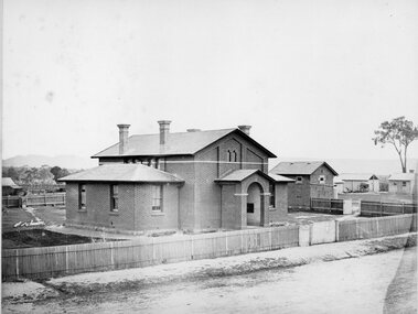 Stawell Historical Society Inc
Photograph, Court House and Cells Pleasant Creek Stawell 1866
... in January 1860. Pleasant Creek Court House was used as a court... in January 1860. Pleasant Creek Court House was used as a court ...Court House and Cells Pleasant Creek Stawell. Part of a collection of Photographs by Mr. O.G. Armstrong as commissioned by the Shire of Stawell for the Inter-colonial and Paris Exhibition in Melbourne in 1866. The first courthouse was built at Pleasant Creek Stawell by William Scobie for the sum of £1975 in September 1858. A further sum of £1832 was spent on the building by J. Francis in January 1860. Pleasant Creek Court House was used as a court of Petty sessions, County Court, Court of Mines, and a Court of General Sessions before the newer Stawell Court House in Patrick Street was built. Later it was used as a police barracks then private home. stawell government -
![View of the railway tunnel through the big hill near Mount Herbert / [by] Nicholas Caire, circa 1876](/media/collectors/550653872162f11fb04854aa/items/57774c0fd0cdd10a5c13912e/item-media/57774c7dd0cdd10a5c13c1ab/item-fit-380x285.jpg) Kew Historical Society Inc
Kew Historical Society IncPhotograph, Anglo-Australasian Photographic Company, View of the railway tunnel through the big hill near Mount Herbert, c. 1876
... reverse l.c.r.: 10 Temple Court, Collins Street West.... reverse l.c.r.: 10 Temple Court, Collins Street West. Albumen ...Nicholas Caire was born on Guernsey in the Channel Islands in 1837. He arrived in Adelaide with his parents in about 1860. In 1867, following photographic journeys in Gippsland, he opened a studio in Adelaide. From 1870 to 1876 he lived and worked in Talbot in Central Victoria. In 1876 he purchased T. F. Chuck's studios in the Royal Arcade Melbourne. In 1885, following the introduction of dry plate photography, he began a series of landscape series, which were commercially successful. As a photographer, he travelled extensively through Victoria, photographing places few of his contemporaries had previously seen. He died in 1918. Reference: Jack Cato, 'Caire, Nicholas John (1837–1918)', Australian Dictionary of Biography, National Centre of Biography, Australian National UniversityAn original, rare photograph from the series 'Views of Victoria: General Series' by the photographer, Nicholas Caire (1837-1918). The series of 60 photographs that comprise the series was issued c. 1876 and reinforced a neo-Romantic view of the Australian landscape to which a growing nationalist movement would respond. Nicholas Caire was active as a photographer in Australia from 1858 until his death in 1918. His vision of the Australian bush and pioneer life had a counterpart in the works of Henry Lawson and other nationalist poets, authors and painters.Albumen silver photograph on boardprinted in ink on support l.c.: VIEW OF THE RAILWAY TUNNEL THROUGH THE BIG HILL NEAR MOUNT HERBERT. / COPYRIGHT REGISTERED. printed in ink on support reverse c.: VIEWS OF VICTORIA. / (GENERAL SERIES.) / No. 10. / VIEW OF THE RAILWAY TUNNEL THROUGH THE BIG HILL NEAR MOUNT HERBERT. / This tunnel is situated on the Mount Alexander and Murray Railway Line, between Castlemaine and Sandhurst, / and is 431 yards long; the completion of this and the remaining portion of the line to Bendigo was celebrated by / great public feasting. The Tunnel is perfectly level, and the spectator is enabled to distinguish objects through it, / as may be seen by the illustration. printed in ink on support reverse l.c.l.: J.W. FORBES, Agent, printed in ink on support reverse l.c.: ANGLO-AUSTRALASIAN PHOTOGRAPHIC COMPANY, MELBOURNE. printed in ink on support reverse l.c.r.: 10 Temple Court, Collins Street West.nicholas caire, landscape photography, mount herbert, railways - victoria -
![Roadway Scene on the Black Spur / [by] Nicholas Caire, circa 1876](/media/collectors/550653872162f11fb04854aa/items/577759b7d0cdd10a5c1a5d0a/item-media/57775a11d0cdd10a5c1aab42/item-fit-380x285.jpg) Kew Historical Society Inc
Kew Historical Society IncPhotograph, Anglo-Australasian Photographic Company, Roadway Scene on the Black Spur, c.1876
... (vertically) on support reverse l.c.l.: 10 Temple Court, Collins... (vertically) on support reverse l.c.l.: 10 Temple Court, Collins ...Nicholas Caire was born on Guernsey in the Channel Islands in 1837. He arrived in Adelaide with his parents in about 1860. In 1867, following photographic journeys in Gippsland, he opened a studio in Adelaide. From 1870 to 1876 he lived and worked in Talbot in Central Victoria. In 1876 he purchased T. F. Chuck's studios in the Royal Arcade Melbourne. In 1885, following the introduction of dry plate photography, he began a series of landscape series, which were commercially successful. As a photographer, he travelled extensively through Victoria, photographing places few of his contemporaries had previously seen. He died in 1918. Reference: Jack Cato, 'Caire, Nicholas John (1837–1918)', Australian Dictionary of BiographyAn original, rare photograph from the series 'Views of Victoria: General Series' by the photographer, Nicholas Caire (1837-1918). The series of 60 photographs that comprise the series was issued c. 1876 and reinforced a neo-Romantic view of the Australian landscape to which a growing nationalist movement would respond. Nicholas Caire was active as a photographer in Australia from 1858 until his death in 1918. His vision of the Australian bush and pioneer life had a counterpart in the works of Henry Lawson and other nationalist poets, authors and painters.Albumen silver photograph mounted on boardprinted in ink on support l.c.: ROADWAY SCENE ON THE BLACK SPUR. / COPYRIGHT REGISTERED printed in ink (vertically) on support reverse u.c.l.: J.W. FORBES, Agent, printed in ink (vertically) on support reverse c.l.: ANGLO-AUSTRALASIAN PHOTOGRAPHIC COMPANY, MELBOURNE. printed in ink (vertically) on support reverse c.: VIEWS OF VICTORIA. / (GENERAL SERIES.) / No. 18. / ROADWAY SCENE ON THE BLACK SPUR. / The road which is represented in this illustration has lately been constructed by the Government at considerable / expense. It is three miles in length from the base to the summit, some portions of which are very steep. Mails / are conveyed by Cobb & Co.'s Coaches to Marysville and Woodspoint via this route daily. The scenery on the Black / Spur, and beyond as far as Myrtle Creek, is exceedinly picturesque. printed in ink (vertically) on support reverse l.c.l.: 10 Temple Court, Collins Street West.nicholas caire (1837-1918), landscape photography, black spur - victoria