Showing 1640 items matching "decade"
-
 Federation University Historical Collection
Booklet, Open Monument, Ballarat, 2015
Soft covered booklet of 41 pages covering the Open Monument by John Young. 'Open Monument' comprises 2 artworks: A 33 laser-etched granite paneled work, 'transculture', and 'Timeline' which extends of 40 metres and depicts the major contributions of the Chinese community in Ballarat, every decade from 1850 until the present. The timeline then folds out with anticipation to 2070. Each page describes aspects of the monument and the Chinese influence. An timeline of Chinese influence is given at the back of the book.non-fictionchinese, mining, multicultural, immigration, tong way, goon, joss house, embroidery, billy butterfly, chinese market gardens, red lion hotel, ah soon, mayor of main road, chinese herbalist, yee lee, james hong, cheok cheong hong, john ah loo, wathawurrung, robe, lowe kong meng, louis ah mouy, tongway, gallipoli, william lung -
 Bendigo Historical Society Inc.
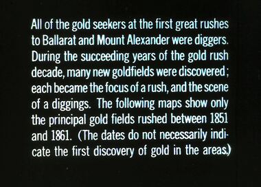
Slide - DIGGERS AND MINERS. DIGGERS AND MINERS, c1850s
Diggers and miners. Diggers and Miners. All or the gold seekers at the first great rushes to Ballarat and Mount Alexander were diggers. During the succeeding years of the gold rush decade, many goldfields were discovered; each became the focus of a rush, and the scene of a diggings. The following maps show only the principal gold fields rushed between 1851 and 1961. (The dates do not necessarily indicate the first discovery of gold in the areas.) Markings: 10 994.5 WAL. Used as a teaching aid.haminounteducation, tertiary, goldfields -
 Deaf Children Australia
Folder, Reports 1969-1974, 1969, 1970, 1972, 1974
The Victorian School for Deaf Children continued an interest in the latest research and information on the education of deaf children. Various reports from the 1969 to 1974 relating to the education of deaf children. Black hard cover magazine cover containing various reports separately bound. 1. Reynolds report 1969 - Observations of Educational programs for hearing impaired children in the U.S.A., England & Russia. 2. Houston report 1970 - Report on Review of Fundraising and Public Relations Activities by Henry Houston, Fund raising consultant. 3. Dawson report 1972 - 'Let the Accent be on Ability' by Shirley Dawson. 4. Rawlings report 1974 - 'The Decade in Review' - the VSDC and the PEKD by Brenda W. Rawlings. Inside front cover: "REYNOLDS REPORT…1969/HOUSTON REPORT…1970/DAWSON REPORT…1972/RAWLINGS REPORT…1974" deaf children australia, dca, victorian school for deaf children, vsdc, deaf education, henry houston, shirley dawson, brenda w. rawlings -
 Bendigo Historical Society Inc.
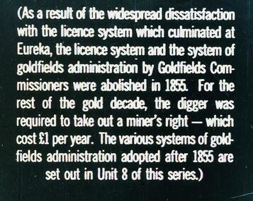
Slide - DIGGERS & MINING. THE GOLD LICENCE, c1855
Diggers & Mining. The gold licence. The Government Camp. (As a result of the widespread dissatisfaction with the licence system which culminated at Eureka, the licence system and the system of goldfields administration by Goldfields Commissioners were abolished in 1855. For the rest of the gold decade, the digger was required to take out a miner's right - which cost 1 pound per year. The various systems of goldfields administration adopted after 1855 are set out in Unit 8 of this series.) Markings: 41 994.LIF. 4. Used as a teaching aid.hanimounteducation, tertiary, goldfields -
![Kew [Willsmere] Mental Hospital](/media/collectors/550653872162f11fb04854aa/items/5c24a85e21ea6710e4eb189a/item-media/5c24a97321ea6710e4ec94fe/item-fit-380x285.jpg) Kew Historical Society Inc
Kew Historical Society IncAlbum, Kew [Willsmere] Mental Hospital, 1872-1965
The new Kew Lunatic Asylum was completed in 1871 and opened in 1872. The year 1972 marked it's centenary. Over the years, members of staff at the asylum collected records, photographs, publications and plans of the asylum, later hospital. The Society has a number of important collections relating to the asylum and the Children's Cottages. These include the Dr Cliff Judge, the Irena Higgins and the Dr Fred Stamp Collections. This item was one of a number donated by the family of the late Dr. Fred Stamp who was the last medical superintendent of the Hospital. Dr Frederick Stamp graduated from Bristol Medical School (UK) in 1968. He and his family emigrated to Australia in 1977 to Goulburn (NSW), moving to Melbourne in 1980. He became Superintendent at Willsmere in 1981 until its closure in 1988.Following their closure, the medical records of the Kew Mental Hospital and the Children's Cottages Kew were relocated to the archives of Victorian Government departments and ultimately to the Public Records Office of Victoria. Other collections, such as the Fred Stamp Collection, were assembled by staff who worked at the hospital. The years leading up to the closure of Kew must have been fraught, and many of the items in the hospital were probably destined for hard waste disposal. Dr. Fred Stamp, the last medical superintendent, kept aside or rescued a number of these items, of which this is one. Following his death, his family donated these to the Kew Historical Society. The Society recognises these items to be of lasting historical significance, essentially due to their provenance and to their rarity. Together they (and the Judge and Higgins Collections) are an invaluable aid for researchers of the institutions' histories.Red vinyl photographic album containing 43 images of the Kew Mental Hospital from its origins until ca. 1965. Within the album, there are a range of photos of various sizes. Photos are typically labelled by date, especially within decade. The photos are of varying quality and historical significance. the subject of the photos in the album include architectural features, internal and external environments, patients and staff. Those to be published separately are deemed to be unique and or significant. The album forms part of the Dr. Fred Stamp Collection.kew lunatic asylum, kew mental hospital, willsmere, kew hospital for the insane, dr fred stamp, the fred stamp collection -
 Kew Historical Society Inc
Photograph, Robert Baker, Exhibition Series - Beyond the Gate 1840-1930, 2014
The Kew Historical Society, founded in 1958, is one of the oldest continuing historical societies in the Greater Melbourne region. From its beginnings, the Society has mounted exhibitions and/or displays, in early days in shop windows and in community spaces located in the Kew City Hall (later Kew Library), and since 2010 at the Kew Court House. Exhibitions typically coincided with the annual Kew Community Festival in March, but after 2013 evolved into three new exhibitions yearly at the Kew Court House. Smaller displays continue to be mounted in the Kew Library.A series of born digital photographs of the framed photographs in the exhibition which explored thirteen historic houses in Kew using old and contemporary photographs. The Houses included: Turanville, D'Estaville, Ivy Grange,Tarring, Charleville, Ramornie, Dalsraith, Heald Lawn, and the James Beament House. Each house was selected as representative of a particular decade. The curators of the exhibition were Robert Baker, Kerry Fairbank and Tony Michael. New photographs of architectural features were taken with the permission of the owner of the house.heritage - kew (vic), kew historical society - exhibitions, historic houses - kew (vic) -
 Kew Historical Society Inc
Map, MMBW, MMBW Plan No.64 Kew & Heidelberg, 1900-1910
The Melbourne and Metropolitan Board of Works (MMBW) was established by an act of the Victorian Parliament in 1890 to prepare for and to implement a sewerage and water reticulation system across what was then inner Melbourne, its surrounding and middle distance suburbs, including Kew. The MMBW was disbanded in 1991.The map collection of the Kew Historical Society has at its core the historic maps assembled and originally stored in the City Engineer's Department of the City of Kew. These include maps in a number of scales. The vast majority of maps were produced by the MMBW in the first two decades of the twentieth century, and are solid working maps, backed by linen for durability. These maps are historically significant to Kew, the City of Boroondara and to the history of the development of state utilities in Victoria. A number of the Kew maps have additional details added by former municipal officers, including the levels reached by various floods. As these were working documents, information was added to them long after the period of their initial production and distribution.Early map of part of the Borough of Kew, created in the first decade of the twentieth century, at a scale 160 ft to 1 inch. The map covers what was then the northern most part of Kew, bordered on its north and west by the Yarra River, in the East by Connor's Creek and by the Asylum in the south. The map shows the extent of urban development by that time, prominent institutions and the outlines of built structures in the municipality. Contour lines and historic flood levels were added in ink to the map at a later stage.MELBOURNE AND METROPOLITAN BOARD OF WORKS / PLAN NO. 64 / KEW & HEIDELBERGmelbourne & metropolitan board of works, mmbw maps, mmbw plans, borough of kew, cartography -
 Kew Historical Society Inc
Map, MMBW, MMBW Plan No.65 Kew & Heidelberg, 1900-1910
The Melbourne and Metropolitan Board of Works (MMBW) was established by an act of the Victorian Parliament in 1890 to prepare for and to implement a sewerage and water reticulation system across what was then inner Melbourne, its surrounding and middle distance suburbs, including Kew. The MMBW was disbanded in 1991.The map collection of the Kew Historical Society has at its core the historic maps assembled and originally stored in the City Engineer's Department of the City of Kew. These include maps in a number of scales. The vast majority of maps were produced by the MMBW in the first two decades of the twentieth century, and are solid working maps, backed by linen for durability. These maps are historically significant to Kew, the City of Boroondara and to the history of the development of state utilities in Victoria. A number of the Kew maps have additional details added by former municipal officers, including the levels reached by various floods. As these were working documents, information was added to them long after the period of their initial production and distribution.Early map of part of the Borough of Kew, created in the first decade of the twentieth century, at a scale 160 ft to 1 inch. The map covers what was then the south central part of Kew, bordered on its north by Malmsbury Street, in the west by Florence Avenue, in the south by Barkers Road, and in the east by Princess Street. The map shows the extent of urban development by that time, prominent institutions and the outlines of built structures in the municipality. Contour lines were added in ink to the map at a later stage.MELBOURNE AND METROPOLITAN BOARD OF WORKS / PLAN NO. 65 / KEW & HEIDELBERGmelbourne & metropolitan board of works, mmbw maps, mmbw plans, borough of kew, cartography -
 Kew Historical Society Inc
Map, MMBW, MMBW Plan No.66 Kew, 1900-1910
The Melbourne and Metropolitan Board of Works (MMBW) was established by an act of the Victorian Parliament in 1890 to prepare for and to implement a sewerage and water reticulation system across what was then inner Melbourne, its surrounding and middle distance suburbs, including Kew. The MMBW was disbanded in 1991.The map collection of the Kew Historical Society has at its core the historic maps assembled and originally stored in the City Engineer's Department of the City of Kew. These include maps in a number of scales. The vast majority of maps were produced by the MMBW in the first two decades of the twentieth century, and are solid working maps, backed by linen for durability. These maps are historically significant to Kew, the City of Boroondara and to the history of the development of state utilities in Victoria. A number of the Kew maps have additional details added by former municipal officers, including the levels reached by various floods. As these were working documents, information was added to them long after the period of their initial production and distribution.Early map of part of the Borough of Kew, created in the first decade of the twentieth century, at a scale 160 ft to 1 inch. The map covers what was then the south eastern part of Kew, bordered on its north by Adeney Avenue, in the west by Sackville Street, in the south by Barkers Road, and in the east by Burke Road. The map shows the extent of urban development by that time, prominent institutions and the outlines of built structures in the municipality. Contour lines were added in ink to the map at a later stage.MELBOURNE AND METROPOLITAN BOARD OF WORKS / PLAN NO. 66 / KEW melbourne & metropolitan board of works, mmbw maps, mmbw plans, borough of kew, cartography -
 Federation University Historical Collection
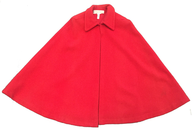
Clothing - Costume, Florgale Uniforms, Nurses Cape, 1950-1990
The red nurses cape has been a feature of the nurses uniform for decades.This unlined red woolen cape has a collar and shoulder epaulets. It is fastened by a metal hook and eye at the neck.The label is stitched at the back neck - Florgale Uniforms, Melbournenursing, nurse cape, red cape, florgale uniforms, nurse uniform, costume -
 Kew Historical Society Inc
Map, MMBW, MMBW Plan No.39 Kew & Heidelberg, 1900-1910
The Melbourne and Metropolitan Board of Works (MMBW) was established by an act of the Victorian Parliament in 1890 to prepare for and to implement a sewerage and water reticulation system across what was then inner Melbourne, its surrounding and middle distance suburbs, including Kew. The MMBW was disbanded in 1991.The map collection of the Kew Historical Society has at its core the historic maps assembled and originally stored in the City Engineer's Department of the City of Kew. These include maps in a number of scales. The vast majority of maps were produced by the MMBW in the first two decades of the twentieth century, and are solid working maps, backed by linen for durability. These maps are historically significant to Kew, the City of Boroondara and to the history of the development of state utilities in Victoria. A number of the Kew maps have additional details added by former municipal officers, including the levels reached by various floods. As these were working documents, information was added to them long after the period of their initial production and distribution.Early map of part of the Borough of Kew, created in the first decade of the twentieth century, at a scale 160 ft to 1 inch. The map covers what was then the north western section of Kew, bordered on its north by Wills Street and the Kew Lunatic Asylum, in the west by the River Yarra [and the later added Yarra Boulevard] , by Princess Street in the East and Holroyd Street in the south. The map shows the extent of urban development by that time, prominent institutions and the outlines of built structures in the municipality. Contour lines were added in ink to the map at a later stage.MELBOURNE AND METROPOLITAN BOARD OF WORKS / PLAN NO. 39 / KEW & HEIDELBERGmelbourne & metropolitan board of works, mmbw maps, mmbw plans, borough of kew, cartography -
 Kew Historical Society Inc
Map, MMBW, MMBW Plan No.67 Kew, 1900-1910
The Melbourne and Metropolitan Board of Works (MMBW) was established by an act of the Victorian Parliament in 1890 to prepare for and to implement a sewerage and water reticulation system across what was then inner Melbourne, its surrounding and middle distance suburbs, including Kew. The MMBW was disbanded in 1991.The map collection of the Kew Historical Society has at its core the historic maps assembled and originally stored in the City Engineer's Department of the City of Kew. These include maps in a number of scales. The vast majority of maps were produced by the MMBW in the first two decades of the twentieth century, and are solid working maps, backed by linen for durability. These maps are historically significant to Kew, the City of Boroondara and to the history of the development of state utilities in Victoria. A number of the Kew maps have additional details added by former municipal officers, including the levels reached by various floods. As these were working documents, information was added to them long after the period of their initial production and distribution.Early map of part of the Borough of Kew, created in the first decade of the twentieth century, at a scale 160 ft to 1 inch. The map covers what was then the north central part of Kew, bordered on its north by the Outer Circle Railway Spruzen and Beresford Avenues, in the west by Princess Street, in the south by High Street, and in the east by (about) Belford Road. The map shows the extent of urban development by that time, prominent institutions and the outlines of built structures in the municipality. Contour lines were added in ink to the map at a later stage.MELBOURNE AND METROPOLITAN BOARD OF WORKS / PLAN NO. 67 / KEW melbourne & metropolitan board of works, mmbw maps, mmbw plans, borough of kew, cartography -
 Kew Historical Society Inc
Map, MMBW, MMBW Plan No.68 Kew, 1900-1910
The Melbourne and Metropolitan Board of Works (MMBW) was established by an act of the Victorian Parliament in 1890 to prepare for and to implement a sewerage and water reticulation system across what was then inner Melbourne, its surrounding and middle distance suburbs, including Kew. The MMBW was disbanded in 1991.The map collection of the Kew Historical Society has at its core the historic maps assembled and originally stored in the City Engineer's Department of the City of Kew. These include maps in a number of scales. The vast majority of maps were produced by the MMBW in the first two decades of the twentieth century, and are solid working maps, backed by linen for durability. These maps are historically significant to Kew, the City of Boroondara and to the history of the development of state utilities in Victoria. A number of the Kew maps have additional details added by former municipal officers, including the levels reached by various floods. As these were working documents, information was added to them long after the period of their initial production and distribution.Early map of part of the Borough of Kew, created in the first decade of the twentieth century, at a scale 160 ft to 1 inch. The map covers what was then the north central part of Kew, bordered in the north by Oak Avenue, in the west by the Yarra River and Connor's Creek, in the south by Beresford and Carnegie Avenues, and in the east by Glass's Creek and Burke Road. The map shows the extent of urban development by that time, prominent institutions and the outlines of built structures in the municipality. Contour lines and the levels of historic floods were added in ink to the map at a later stage.MELBOURNE AND METROPOLITAN BOARD OF WORKS / PLAN NO. 68 / KEW melbourne & metropolitan board of works, mmbw maps, mmbw plans, borough of kew, cartography -
Moorabbin Air Museum
Document (Item) - Draft of Speech Regarding the Potential of Aviation Developments in the 1970s, Speakers Notes
The speech, drafted in January 1968, was looking forward to the 1970s as a decade of "exciting developments" -
 Federation University Historical Collection
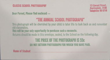
Envelope, Annual School Photograph Envelope, c1970s
Classic school photography took Ballarat Junior Technical School photographs for over a decadeyellow rectangle envelope with red and green printing for payment of school photograph13 Edward Street Huntingdale 3168 Telephone 56 6718 Classic School Photoghraphy Dear Parent, Please find enclosed- "THE ANNUAL SCHOOL PHOTOGRAPH" This photograph will be cherished by your child in later life to look back on and remember old classmates. This will be your only opportunity to purchase such a memento. Returns should be made in this envelope, sealed, to the School on the following day. THE PRICE OF THE PHOTOGRAPH IS 55c Do not return photograph for which you have paid. Name of Studentenvelope, school photograph, classic school photography, ballarat junior technical school -
 Galen Catholic College
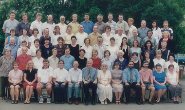
Galen Catholic College Staff: 2000 - 2010
This is a series of staff photos taken in the first decade of the new millennium at Galen Catholic College.galen, galen catholic college, galen college, staff -
 Greensborough Historical Society
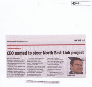
Newspaper Clipping, Diamond Valley Leader, CEO named to steer North East Link project, 01/03/2017
An engineer with decades of experience will be appointed chief executive of the new specialist North East Link Authority.News article 1 page, black text, colour image.north east link, metropolitan ring road, duncan elliott -
 Greensborough Historical Society
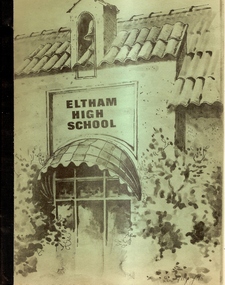
Book, Eltham High School - A history 1926-1978 - El7805, 1926-1978
Published on the occasion of the Jubilee celebrations 1978. Written by Max Balchin. Includes a brief history of each decade.A record of the early days of Etham High School.Black and white photographs, approx 60 pages. Green card cover with a drawing of Eltham High School. Includes loose page from the Jubilee Celebrations 1978.eltham high school, max balchin, jubilee celebrations -
 National Wool Museum
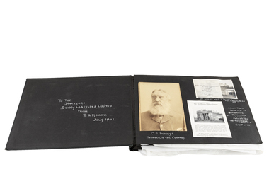
Photograph Album, T.G. Moore Album
Property of Jim Hay, geelong property manager of Elders Pastoral.Large bound photo album with black cloth cover containing pictures, notices, documents and news paper articles documenting Denny's Lascelles Wool brokers and Strachan Wool brokers. Pictures and documents are mounted on black card using glue and sticky tape, on both the front and back of pages. There are five photographs and one document not attached to the album that illustrate Denny's Lascelles Wool brokers. Photos feature different events across several decades related to the Dennys Lascelles Wool Store, including newspaper clippings, men driving a car and staff photos."To the Directors Denny's Lascelles Limited From T.G. Moore July 1941wool brokering wool stores wool industry, elders pastoral dennys, lascelles limited strachan and co. limited, hay, mr jim e. - elders vp, geelong, victoria, wool brokering, wool stores, wool industry -
 Bendigo Historical Society Inc.
Slide - DIGGERS & MINING. GETTING THE GOLD, c1850s
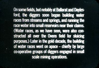
Diggers & Mining. Getting the Gold. Slide: On some fields, but notably at Ballarat and Daylesford, the diggers soon began building water races from streams and springs, and running the race water into small reservoirs near their claims. (Water races, as we have seen, were also constructed all over the Ovens field for sluicing purposes.) Later in the gold decade, the building of water races went on space - chiefly by large co-operative groups of diggers engaged in small scale mining operations. Markings: 69 994.LIF:4. Used as a teaching aid.hanimounteducation, tertiary, goldfields -
 Kew Historical Society Inc
Map, MMBW, MMBW Plan No.40 Collingwood & Kew, 1900-1910
The Melbourne and Metropolitan Board of Works (MMBW) was established by an act of the Victorian Parliament in 1890 to prepare for and to implement a sewerage and water reticulation system across what was then inner Melbourne, its surrounding and middle distance suburbs, including Kew. The MMBW was disbanded in 1991.The map collection of the Kew Historical Society has at its core the historic maps assembled and originally stored in the City Engineer's Department of the City of Kew. These include maps in a number of scales. The vast majority of maps were produced by the MMBW in the first two decades of the twentieth century, and are solid working maps, backed by linen for durability. These maps are historically significant to Kew, the City of Boroondara and to the history of the development of state utilities in Victoria. A number of the Kew maps have additional details added by former municipal officers, including the levels reached by various floods. As these were working documents, information was added to them long after the period of their initial production and distribution.Early map of part of the Borough of Kew, created in the first decade of the twentieth century, at a scale 160 ft to 1 inch. The map covers what was then the south western section of Kew, bordered on its north by Studley Park Road, in the west by Walmer Street and the River Yarra, by High Street South and Princess Street in the East and Barkers Road in the south. The map shows the extent of urban development by that time, prominent institutions and the outlines of built structures in the municipality. Contour lines and historic flood levels were added in ink to the map at a later stage.MELBOURNE AND METROPOLITAN BOARD OF WORKS / PLAN NO. 40 / COLLINGWOOD & KEWmelbourne & metropolitan board of works, mmbw maps, mmbw plans, borough of kew, cartography -
 City of Moorabbin Historical Society (Operating the Box Cottage Museum)
Newsletter - City of Moorabbin Historical Society Feb 2008, February 2008
The City of Moorabbin Historical Society was formed c 1960 by a group of Moorabbin residents who were concerned that the history of the area should be preserved. A good response to a call for items related to the historical area of Moorabbin Shire brought donations of a wide variety of artefacts which are now preserved by the current members of CMHS at Box Cottage Museum . Helen Stanley, Secretary of CMHS, began producing a Newsletter for members in April 2007 to provide current information and well researched items of historical interest. Helen Stanley has produced a bi-monthly Newsletter, 2007 - 2013, for the members of the City of Moorabbin Historical Society that contains well researched interesting historical items, notification of upcoming events, current advice from Royal Australian Historical Society , Museums Australia Victoria and activities of Local Historical Societies. The Newsletter is an important record of the activities of the CMHS. The Lawson family were early settlers in Moorabbin Shire. A4 paper printed both sides x1. Issue 4 of the bi-monthly, City of Moorabbin Historical Society Newsletter produced by Society member and Secretary, Mrs Helen Stanley in October 2007. Dr G Whitehead’s talk is rescheduled for April 27th. Nan Lawson, CMHS member and Volunteer for many groups over 3 decades has been awarded Medal of the Order of Australia. Information about Friends of Cheltenham and Regional Cemeteries group and recent publication of 'Glimpses of Chelsea' by Chelsea Historical Society. Reminder that subscriptions are due now. $3CITY of MOORABBIN HISTORICAL SOCIETY / FEBRUARY 2008 NEWSLETTERcity of moorabbin historical society, stanley helen, melbourne, moorabbin, brighton, chelsea, cheltenham, ormond, bentleigh, market gardeners, pioneers, early settlers, moorabbin shire, sheehy tom, whitehead dr graham, lawson bob, lawson nan, box cottage museum, booker john, dendy henry, highett, cheltenham pioneer cemetery, friends of cheltenham and regional cemeteries, chelsea historical society -
 Kiewa Valley Historical Society
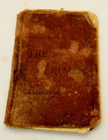
Book - Student Text Book, The Primer Illustrated, Late 19th Century
This book is not dated but, using some of the illustrations as a guide, an approximation can be made at last two decades of the 19th century.There is no direct link to the Kiewa Valley but it demonstrates the way reading was taught, to children commencing school, using the phonic system and would have been a valuable resource to the small schools in the area A moroon, cloth covered school book of 64 pages.On the front cover is Victoria, The Primer, Illustrated. On the bottom right hand corner is Price 3d. There are no personal markings. The directions for use are on the inside of the front cover and continued on the inside of the back cover.schools, education, book -
 Greensborough Historical Society
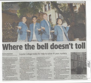
Newspaper Clipping, Diamond Valley Leader, Where the bell doesn't toll, 18/12/2019
Watsonia's Loyola College is asking for help to track down a bell that's been missing for more than four decades.News article 1 page, black text, colour image.watsonia, loyola college, missing bell, loyola seminary -
Port Melbourne Historical & Preservation Society
Photograph - Port Melbourne for premiers 2002 banner, Town Hall, Bay Street, Sep 2002
Banner was hung by Port Phillip council when 'the Borough' made the finals for the first time in two decades. (subsequently lost)Colour photo (portrait) of Port Melbourne Town Hall, with banner 'Port Melbourne for premiers 2002'port melbourne town hall, sport - australian rules football, port melbourne football club, pmfc -
 Hume City Civic Collection
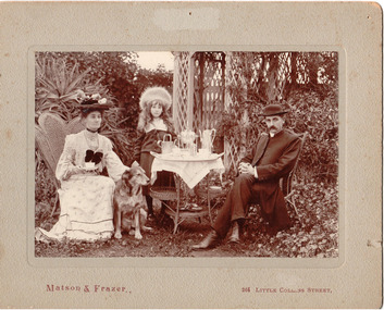
Photograph, c1907
The Rev. Charles Edward Gayer was the vicar at St. Mary's Church of England in Sunbury during the early decade of the twentieth century.A sepia coloured photo of the Rev and Mrs Gayer with their daughter, Crystal, in a garden setting with an afternoon tea set up. The photo is mounted on a grey cardboard mat. There are a number of stains and some foxing on it and also a number of pin holes and an area of superficial paper loss centre top of the mat.Matson and Frazer 264 Collins Streetgayer, rev charles edward, - (mrs), george evans collection -
 Bendigo Military Museum
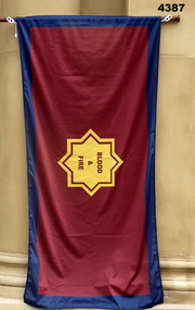
Flag - SALVATION ARMY FLAG, Carroll and Richardson, 2020
This flag was donated to SMIMM to HONOR the service and assistance that the Salvation Army has rendered the Australian Forces over many decades.Salvation Army flag, rectangular shape, colours are outer rim blue all around, centre magenta, middle an 8 pointed gold star with Magenta wording, a white cord and loop at one endCentral, “BLOOD & FIRE”flags, salvation army -
 Federation University Historical Collection
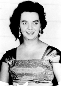
Photograph, Heather Walton (Durant)
Heather Walton married Bill Durant. She worked at the Ballarat School of Mines library for decades, and retired from the University of Ballarat.A portrait of Heather Walton at a student ball. heather durant, heather walton, alumni, staffmember, university women, library -
 Southern Sherbrooke Historical Society Inc.
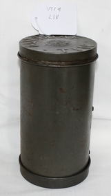
Nut loaf tin, Circa 1965
Bought by Susan Heywood-Downard in the 1960's and used to make nut loafs for decades. Donated to Southern Sherbrooke Historical Society.Cylindrical tin made from aluminum. Used for cooking nut loaf. Made up of 2 lids and circular rolled central piece. Hole on one lid to let steam out.'Nut Loaf 170 m/m X 80 m/m' and 'Willow Australia' on one lid. 'Nut loaf tin' and 'Made in Australia' on other lid. -
 Eltham District Historical Society Inc
Newsletter, Newsletter, No. 11, March 1980
Contents: • Annual General Meeting Agenda • A decade of history – some impressions of Eltham in the 1970s • Eltham, England • Nillumbik Historical Society The Shire of Eltham Historical Society was formed in October 1967. The first newsletter of the Society was issued May 1978 and has been published continuously ever since on a bi-monthly basis. With the cessation of the Shire of Eltham in late 1994, the Society's name was revised to Eltham District Historical Society and this name first appeared with issue No. 103, July 1995. The collection of the Society's newsletters provides a valuable resource on the history of the Society's activities, office bearers and committee members, guest speakers and subjects of historical interest pertinent to the former Shire of Eltham and the Eltham District.A4 photocopied newsletter distributed to membersnewsletter, eltham district historical society, shire of eltham historical society