Showing 833 items
matching diamond creek road
-
 Greensborough Historical Society
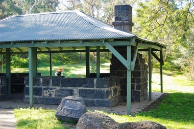
Photograph - Digital Image, Pioneer Reserve 2014 -4, 23/09/2014
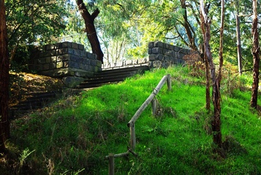
... on the corner of St Helena and Diamond Creek Roads. It is adjacent... is a small park on the corner of St Helena and Diamond Creek Roads ...Pioneer Reserve, Greensborough is a small park on the corner of St Helena and Diamond Creek Roads. It is adjacent to the site of Greensborough's first bridge across the Plenty River, c. 1864 - 1960s. The shelter, viewing platform, retaining wall and entrance are built from the bridge's massive bluestone arched abutments dismantled between 1974 and 1983. Photograph by Marilyn Smith 2014.Digital copy of colour photograph.pioneer reserve greensborough -
 Greensborough Historical Society
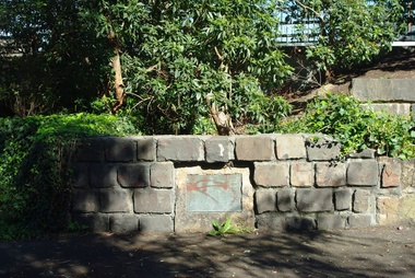
Photograph - Digital Image, Pioneer Reserve 2014 -5, 23/09/2014
... on the corner of St Helena and Diamond Creek Roads. It is adjacent... is a small park on the corner of St Helena and Diamond Creek Roads ...Pioneer Reserve, Greensborough is a small park on the corner of St Helena and Diamond Creek Roads. It is adjacent to the site of Greensborough's first bridge across the Plenty River, c. 1864 - 1960s. The shelter, viewing platform, retaining wall and entrance are built from the bridge's massive bluestone arched abutments dismantled between 1974 and 1983. Photograph by Marilyn Smith 2014.Digital copy of colour photograph.pioneer reserve greensborough -
 Greensborough Historical Society
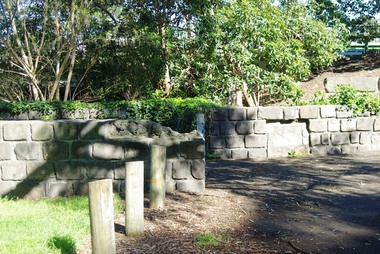
Photograph - Digital Image, Pioneer Reserve 2014 -6, 23/09/2014
... on the corner of St Helena and Diamond Creek Roads. It is adjacent... is a small park on the corner of St Helena and Diamond Creek Roads ...Pioneer Reserve, Greensborough is a small park on the corner of St Helena and Diamond Creek Roads. It is adjacent to the site of Greensborough's first bridge across the Plenty River, c. 1864 - 1960s. The shelter, viewing platform, retaining wall and entrance are built from the bridge's massive bluestone arched abutments dismantled between 1974 and 1983. Photograph by Marilyn Smith 2014.Digital copy of colour photograph.pioneer reserve greensborough -
 Greensborough Historical Society
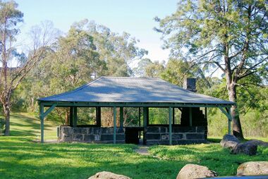
Photograph - Digital Image, Pioneer Reserve 2014, 23/09/2014
... on the corner of St Helena and Diamond Creek Roads. It is adjacent... is a small park on the corner of St Helena and Diamond Creek Roads ...Pioneer Reserve, Greensborough is a small park on the corner of St Helena and Diamond Creek Roads. It is adjacent to the site of Greensborough's first bridge across the Plenty River, c. 1864 - 1960s. The shelter, viewing platform, retaining wall and entrance are built from the bridge's massive bluestone arched abutments dismantled between 1974 and 1983. Photograph by Marilyn Smith 2014.Digital copy of colour photograph.pioneer reserve greensborough -
 Greensborough Historical Society
Photograph - Digital Image, Pioneer Reserve 2014 -8, 23/09/2014
... on the corner of St Helena and Diamond Creek Roads. It is adjacent... is a small park on the corner of St Helena and Diamond Creek Roads ...Pioneer Reserve, Greensborough is a small park on the corner of St Helena and Diamond Creek Roads. It is adjacent to the site of Greensborough's first bridge across the Plenty River, c. 1864 - 1960s. The shelter, viewing platform, retaining wall and entrance are built from the bridge's massive bluestone arched abutments dismantled between 1974 and 1983. Photograph by Marilyn Smith 2014.Digital copy of colour photograph.pioneer reserve greensborough -
 Greensborough Historical Society
Map, Melbourne and Metropolitan Board of Works. Survey Division, MMBW, Yarra 2500 / 13.21. Central Greensborough, 1979_05
... and Diamond Creek Road.... Street, Para Road, St Helena Road and Diamond Creek Road. mmbw ...Melbourne and Metropolitan Board of Works. Yarra 2500 [base map]. 13-21, Parishes of Keelbundora 2856 and Nillumbik 3310, Municipality of Diamond Valley 257. Shows street names, easement sizes, lot numbers, lodged plan numbers, names of prominent features, contour values, creek or river names. Central Greensborough. Prominent streets: Main Street, Para Road, St Helena Road and Diamond Creek Road.MMBW Map in 1:2500 [scale] series. Cream parchment with green tape reinforcing on edges and punched holes on left edge.mmbw, melbourne and metropolitan board of works, shire of diamond valley, greensborough - maps -
 Greensborough Historical Society
Map, Melbourne and Metropolitan Board of Works. Survey Division, MMBW, Yarra 2500 / 13.22. Greensborough, Apollo Parkways, 1979_06
... River Drive, Diamond Creek Road and Civic Drive. Includes... streets include: Plenty River Drive, Diamond Creek Road and Civic ...Melbourne and Metropolitan Board of Works. Yarra 2500 [base map] 13-22. Greensborough, Apollo Parkways. Parishes of Nillumbik 3310 and Keelbundora 2856. Municipalities of Diamond Valley 257 and Whittlesea 239. Prominent streets include: Plenty River Drive, Diamond Creek Road and Civic Drive. Includes Diamond Valley Civi Centre, Churinga, Janefield Colony Reserve and "proposed freeway" now Greensborough Highway (Bypass)MMBW Map in 1:2500 [scale] series. Cream parchment with green tape reinforcing on edges and punched holes on left edge.mmbw, melbourne and metropolitan board of works, shire of diamond valley, greensborough - maps, apollo parkways - maps -
 Greensborough Historical Society
Poster - Planning Document, City of Heidelberg, Subdivision Plan # G 27, Greensborough and Diamond Creek, 1922 and 1963
... Parish of Nillumbik, Portion 13: Plan 1: Diamond Creek Road... Parish of Nillumbik, Portion 13: Plan 1: Diamond Creek Road ...Plan of Subdivisions in City of Heidelberg: Side 1: 2 plans, Parish of Keelbundoora: plan 1: Henry Street, Vermont Avenue, Lyell Street, Nell Street, McDowell Street, 1922. Plan 2: Henry Street, Nepean Street, Charles Street, 1922. Side 2: 2 plans Parish of Nillumbik, Portion 13: Plan 1: Diamond Creek Road, Delfin Crescent, Ridge Road, 1963. Plan 2: Kinglake Road, Eltham Road, 1963.An example of hard copy subdivision plans from the Greensborough area. Mainly from the Shire of Diamond Valley era (1964-1994).Plan (2 sided) mounted on heavy card. Contains 2 sheets pasted together.Stamped and handwritten Council permissions, dates and other details.subdivision plans, city of heidelberg -
 Greensborough Historical Society
Document - Certificate of Title, Flintoff land, 1897o
... . Plenty River to Diamond Creek Road (plan) shows land belonging... and John McLaughlin. 4. Plenty River to Diamond Creek Road (plan ...1. Certificate of Title: Edith Flintoff 26/10/1897: Vol. 2659 Fol.531750. 2. Transfers of (1) Edith Flintoff, Edith Fullwood, John Bosch. 3. List of transfers from Frederick Nevins Flintoff including to Robert Whatmough and John McLaughlin. 4. Plenty River to Diamond Creek Road (plan) shows land belonging to Edith Flintoff, Edith Fullwood, John Bosch. 5. Register of proprietors including Edith Flintoff of Nillumbik, Portion 14, Vol. 2659 Fol.531750.Shows part of the chain of ownership of this parcel of land in Greensborough.5 pages. Copies of land titles and associated documentsflintoff family, land titles - greensborough -
 Eltham District Historical Society Inc
Photograph, Main Road, Eltham South, near Eltham Park, flooded by the Diamond Creek, 30 Nov. 1934
... Diamond Creek across Main Road in 1934. Left of centre shows Mr...), floodwaters from the Diamond Creek cut off the Main road into Eltham ...Near Eltham Park (now known as Eltham Lower Park), floodwaters from the Diamond Creek cut off the Main road into Eltham at Bremner’s Flats (present day Wingrove Park). In the distance, left of centre, is Mr. Montieth's Ford Wagonette stranded in the floodwater near Wingrove Cottage. “On the Lower Eltham Reserve the water was nearly five feet deep across the reserve and over a mile along the road. All the week-end shops are surrounded. For over 40 years flood waters have not reached this unprecedented level.” - Advertiser, Friday November 30, 1934, p7 "Whilst we were at the shop a "tidal" wave occured . There used to be a Mr. Monteith who ran a Model T Ford bus from the Eltham Railway Station down the main street. The bus would hold seven, six seated in the back, 3 aside a seventh standing on the step on the middle of the back hanging on to two small hand rails. The bus was caught by the flood and was abandoned not far from our shop in the paddocks towards the Higher Elementary School. It was there for days and after the flood waters receded, Mr. Monteith, after removing all the mud and debris gave the engine one turn with the handle and it started first time! So the story goes! " (Doug Orford Reminiscences, 2004) The 1934 flood of the Diamond Creek and Yarra River is the highest recorded flooding in the district and set the standard for the current planning flood plain level.Black and white photograph showing the floodwater from Diamond Creek across Main Road in 1934. Left of centre shows Mr. Montieth's Ford Wagonette in the floodwater in the distancefloods, main road, eltham south, diamond creek (creek), wingrove cottage, wingrove park, bus services, bremner's flat, eltham park, ford wagonette, mr. montieth, floodwater, reminscences -
 Greensborough Historical Society
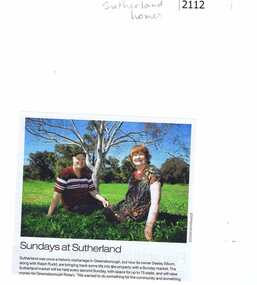
Newspaper clipping, Diamond Valley Leader, Sundays at Sutherland, 2013_
... . It was at 14 Yan Yean Road, Diamond Creek. At the intersection of Yan.... It was at 14 Yan Yean Road, Diamond Creek. At the intersection of Yan ...Desley Elkhom and Ralph Rudd, the owners of Sutherland (once an orphanage) run a Sunday market to raise money for Rotary. Neisha Forbes email 1/4/2017: "In this photograph is of my brother, Ralph Rudd and his partner Desley Elkhom, they were setting up a market at Sutherland Homes site – a community market trying to bring on local produce, and involve the Plenty CFA to raise money for equipment. It ran for about 2 years, but sadly as they did not have indoor cover, it either rained on the Sunday, they had the stalls, but did not get the people, or had the people and no stalls. It stopped about a 18 months ago. It was at 14 Yan Yean Road, Diamond Creek. At the intersection of Yan Yean Road and Diamond Creek Road, the old Sutherland Homes property."News clipping, black text, colour image. Text incomplete. -
 Greensborough Historical Society
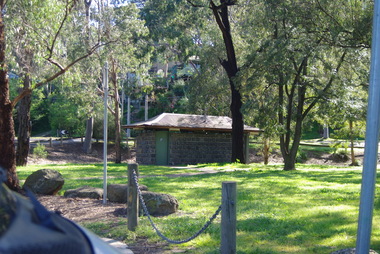
Photograph - Digital Image, Pioneer Reserve 2014 -1, 21/05/2014
... on the corner of St Helena and Diamond Creek Roads. It is adjacent... is a small park on the corner of St Helena and Diamond Creek Roads ...Pioneer Reserve, Greensborough is a small park on the corner of St Helena and Diamond Creek Roads. It is adjacent to the site of Greensborough's first bridge across the Plenty River, c. 1864 - 1960s. The shelter, viewing platform, retaining wall and entrance are built from the bridge's massive bluestone arched abutments dismantled between 1974 and 1983. Pioneer Reserve is historically significant for its formative association with noted local landscape designer Gordon Ford in 1968, and it is likely that remnant large field stones at the entrance drive to the Reserve remain from his design. Photograph by Marilyn Smith 2014.Digital copy of colour photograph. -
 Eltham District Historical Society Inc
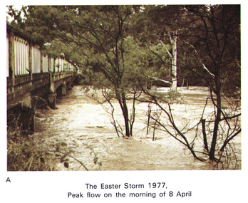
Work on paper (Sub-Item) - Photograph, Main Road Bridge, Eltham peak flow of flood 8 April, 1977
... Colour photograph. Flooding of Diamond Creek at Main Road... melbourne Colour photograph. Flooding of Diamond Creek at Main Road ...Colour photograph. Flooding of Diamond Creek at Main Road Bridge, Eltham peak flow of flood. Easter storm, 8 April, 1977flood, diamond creek, flooding, eltham, bridge, main road -
 Eltham District Historical Society Inc
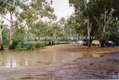
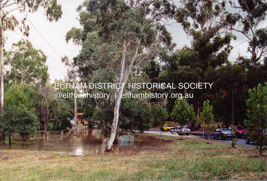
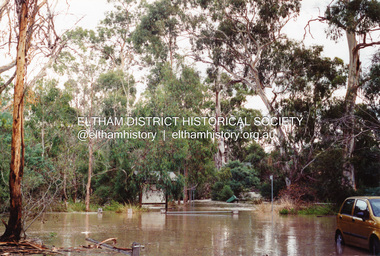
Photograph, Flooding of Diamond Creek at Lower Eltham, Feb 2005, 2005
... Three colour photographs of the flooded Diamond Creek... melbourne eltham main road diamond creek floods dalton street ...Three colour photographs of the flooded Diamond Creek showing Main Road floodwater below Dalton Street (Eltham Primary) school, west side of Diamond Creek near flower stall and Wingrove Park, Feb 2005eltham, main road, diamond creek, floods, dalton street, wingrove park -
 Eltham District Historical Society Inc
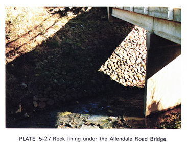
Work on paper (Sub-Item) - Photograph, Rock lining under the Allendale Road Bridge, 1976
... Colour photograph of rock lining along the Diamond creek... melbourne Colour photograph of rock lining along the Diamond creek ...Colour photograph of rock lining along the Diamond creek under the Allendale Road Bridge, Eltham Northrock lining, bridge, eltham north, diamond creek -
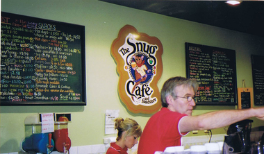 Greensborough Historical Society
Photograph - Digital image, Frank Solomon, The Snug Cafe St Helena 1, 1990c
... 10 St Helena Market Place Aqueduct Road Diamond Creek Vic... information: Shop 10 St Helena Market Place Aqueduct Road Diamond ...St Helena Marketplace was the site of "The Snug". These photographs were taken by Frank Solomon and depict a cafe called The Snug, which is no longer operating. [Location information: Shop 10 St Helena Market Place Aqueduct Road Diamond Creek Vic 3089] Digital copy of colour photographthe snug, st helena marketplace, st helena -
 Eltham District Historical Society Inc
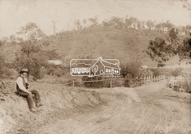
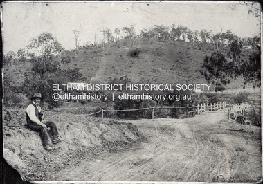
Photograph, Mr Belot smokes his pipe whilst resting at Cottle's Bridge, c.1890
... , and the original bridge over the Diamond Creek on the road to Strathewen..., and the original bridge over the Diamond Creek on the road to Strathewen ...The area, previously known as Back Creek, was named after Thomas Cottle, who settled in the district in the 1870s, and the original bridge over the Diamond Creek on the road to Strathewen. The original bridge (seen in the photo) was replaced with a new timber bridge at a cost of £1,500, the tender being awarded to a contractor named Birch who commenced work in June 1927. The gentleman in the photo who is resting whilst having a smoke of his pipe is a member of the Belot family.Original sepia photograph mounted on card broken lower left corner and cracked upper rightbelot, bridge, cottles bridge, cottles bridge-strathewan road, diamond creek (creek), heidelberg-kinglake road -
 Eltham District Historical Society Inc
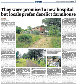
Newspaper - News Clipping, Adam Carey, They were promised a new hospital, but locals prefer derelict farmhouse, The Age, December 4, p11, 2023
... by the Department of Transport at 405 Ryans Road, Diamond Creek. The site... by the Department of Transport at 405 Ryans Road, Diamond Creek. The site ...The Age, Monday, December 4, 2023, p11 Article about local protest at Victorian Government decision to build a community hospital on the site of an old derleict farmhouse owned by the Department of Transport at 405 Ryans Road, Diamond Creek. The site was until 2017 part of a potential route fior the North East Link.community hospital, cr. ben ramcharan, cr. natalie duffy, department of ttransport, diamond creek, eltham community hospital, james bant, james merrett, martin penrose, north east link, petition, protest, ryans road -
 Eltham District Historical Society Inc
Photograph, Main Road, Eltham South, corner of Falkiner Street, flooded by the Diamond Creek, 1934
... View of the Diamond Creek flooding across Main Road looking... melbourne View of the Diamond Creek flooding across Main Road ...View of the Diamond Creek flooding across Main Road looking towards Eltham at intersection with Falkiner Street; a Council truck blocking Main Road, Eltham Lower Park on right, Eltham Park Tea Rooms (later Ansell and Muir) on left fooded. The bridge can just be seen on far right centre.Black and white photographmain road, eltham south, ansell and muir, diamond creek (creek), eltham park, eltham park tea room, falkiner street, floods, floodwater -
 Eltham District Historical Society Inc
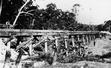
Photograph, Railway Bridge construction between Eltham and Hurstbridge, c.1912
... . This bridge is most likely near Allendale Road, Diamond Creek... in 1912. This bridge is most likely near Allendale Road, Diamond ...The railway was extended from Eltham to Hurstbridge in 1912. This bridge is most likely near Allendale Road, Diamond Creek. It was one of four original trestle bridges in the stretch north of Allendale Road, which were all burnt out in January 1969 (replaced by two steel bridges and two corrugated iron culverts).This photo forms part of a collection of photographs gathered by the Shire of Eltham for their centenary project book,"Pioneers and Painters: 100 years of the Shire of Eltham" by Alan Marshall (1971). The collection of over 500 images is held in partnership between Eltham District Historical Society and Yarra Plenty Regional Library (Eltham Library) and is now formally known as the 'The Shire of Eltham Pioneers Photograph Collection.' It is significant in being the first community sourced collection representing the places and people of the Shire's first one hundred years.Digital image One 4 x 5 inch B&W negative One 9 x 12.5 cm printshire of eltham pioneers photograph collection, hurstbridge, allendale road, hurstbridge railway extension, railway bridge, railway line construction, trestle bridge, diamond creek (creek) -
 Eltham District Historical Society Inc
Negative - Photograph, Mr Belot smokes his pipe whilst resting at Cottle's Bridge, c.1990 (c.1890)
... Creek on the road to Strathewen. The original bridge (seen... diamond creek (creek) heidelberg-kinglake road Film - Agfa Ortho ...Copy of original photograph. The area, previously known as Back Creek, was named after Thomas Cottle, who settled in the district in the 1870s, and the original bridge over the Diamond Creek on the road to Strathewen. The original bridge (seen in the photo) was replaced with a new timber bridge at a cost of £1,500, the tender being awarded to a contractor named Birch who commenced work in June 1927. The gentleman in the photo who is resting whilst having a smoke of his pipe is a member of the Belot family.Roll of 35mm Black and White negative film, 3 strips, (1 of 14 frames)Film - Agfa Ortho 25belot, bridge, cottles bridge, cottles bridge-strathewan road, diamond creek (creek), heidelberg-kinglake road -
 Eltham District Historical Society Inc
Photograph, M. North, Main Road, Eltham near Fitzsimons Lane Roundabout, Dec 1985, 1/12/85
... the Diamond Creek, Eltham Main Road now dual highway, through Lower... the Diamond Creek, Eltham Main Road now dual highway, through Lower ...Two colour photographs of Main Road, ElthamSouth between Falkiner Street and Bolton Street at the roundabout of Fitzsimons Lane, Eltham, Dec 1985Noted on 463B 'See 1934 small black and white snap of flooded bridge and the same two shops. This snap taken from same location, Dec 1985. Old Eltham Park on right of photo The two shops at left (Ansel and Muir) Road ahead crosses new bridge over the Diamond Creek, Eltham Main Road now dual highway, through Lower Plenty to this bridge'main road, eltham, eltham south, fitzsimons lane, round about, falkiner street -
 Eltham District Historical Society Inc
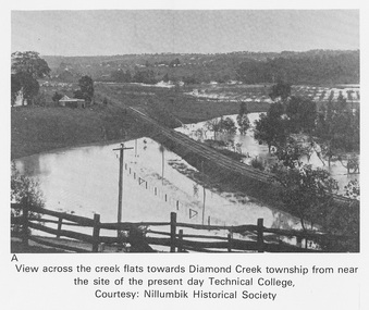
Work on paper (Sub-Item) - Photograph, View across the creek flats towards Diamond Creek township
... of Diamond Valley College, Main Hurstbridge Road, Diamond Creek... the creek flats towards Diamond Creek township showing the railway ...Undated black and white photograph of view across the creek flats towards Diamond Creek township showing the railway line, with the Diamond Creek under flood. Situated behind the vicinity of Diamond Valley College, Main Hurstbridge Road, Diamond Creek. Diamond Valley College was formed in 1989 from the almagamation of Diamond Creek Technical School and Hurstbridge High School. Nillumbik Historical Society collectionflood, diamond creek, nillumbik historical society -
 Eltham District Historical Society Inc
Document - Folder, Sartori, Alan
... 100 Ironbark Road Diamond Creek... Greensborough to live and have his studio at Diamond Creek, 100 Iron.... Alan Sartori 100 Ironbark Road Diamond Creek Cerel Sartori Irma ...Alan Sartori became an artist in 1974, moving from Greensborough to live and have his studio at Diamond Creek, 100 Iron bark Road; he also wrote a book "Alan Sartori's Stories" in 1992. He died in 2007. Contents Newspaper article: "Alan's artful life", Diamond Valley News, 23 November 1992. Alan Sartori to exhibit at his studio in November and December 1992. Newspaper article: "Artist paints views of his state", Diamond Valley newspaper, no date. Alan Sartori to exhibit at his studio in November and December that year. Newspaper article: "Loss of an 'amazing' extrovert", Report of funeral of Alan Sartori. Newspaper article: "Art and memories", Diamond Valley newspaper, no date. An exhibition to be held of the late Alan Sartori's work at his studio. Newspaper clippings, A4 photocopies, etcalan sartori, 100 ironbark road diamond creek, cerel sartori, irma sartoria, g j coles, nilumbik artists open studios, tony summers, martyn thompson, rotary club greensborough, victorian artists society -
 Eltham District Historical Society Inc
Negative - Photograph, Bridge on Main Road, Eltham, c.1890
... wooden suspension bridge over the Diamond Creek on Main Road... wooden suspension bridge over the Diamond Creek on Main Road ...Possibly produced as a postcard. Caption in lower right hand corner reads: Bridge (at) Main Road Eltham. The long wooden suspension bridge over the Diamond Creek on Main Road at Eltham collapsed during flooding of the Diamond Creek on October 13 and 14, 1923. The original bridge was built around 1840 for the coach road when Cobb & Co.'s coach was the only conveyance between Eltham and Melbourne. Widespread damage was done in Melbourne and surrounding areas by floods resulting from the overflow of the Yarra at many points along its banks. A temporary bridge rigged up was severely damaged by the flooding of the creek and was closed to vehicular traffic in April 1924. A new concrete bridge was constructed to replace it and by May 1926 all the concrete piles and abutments had been completed. The bridge was finally completed and opened for traffic in September 1926, almost three years after it initially collapsed. Viewed from Antoinette Boulevard looking northwest towards Falkiner Street. The building in the distance believed to be Souters Cottage. On the far right on the very edge of the road verge are two Eucalypt trees, one of which is believed to be the large dead trunk still standing in present day.This photo forms part of a collection of photographs gathered by the Shire of Eltham for their centenary project book,"Pioneers and Painters: 100 years of the Shire of Eltham" by Alan Marshall (1971). The collection of over 500 images is held in partnership between Eltham District Historical Society and Yarra Plenty Regional Library (Eltham Library) and is now formally known as the 'The Shire of Eltham Pioneers Photograph Collection.' It is significant in being the first community sourced collection representing the places and people of the Shire's first one hundred years.Digital image 4 x 5 inch B&W Neg Black and white print 35mm positive transparencyshire of eltham pioneers photograph collection, eltham, main road bridge, eltham south, bridge, diamond creek (creek), significant tree, souters cottage, eltham lower park, main road, sepp -
 Eltham District Historical Society Inc
Photograph - Photograph postcard, The Rose Stereograph Company, View at Eltham, Vic. Postcard sent from Ernest and family to Joe, 3 May 1936, c.1920
... the original Main Road Bridge and the Diamond Creek from near... the original Main Road Bridge and the Diamond Creek from near ...Postcard sent from Ernest and family to Joe, 3 May 1936. Original photo estimated to be circa 1920. Looking west across the original Main Road Bridge and the Diamond Creek from near the intersection of Antoinette Boulevard. To the right of the bridge appear to be orchard trees in flood waters. The long wooden suspension bridge over the Diamond Creek on Main Road at Eltham collapsed during flooding of the Diamond Creek on October 13 and 14, 1923. The original bridge was built around 1840 for the coach road when Cobb & Co.'s coach was the only conveyance between Eltham and Melbourne. Widespread damage was done in Melbourne and surrounding areas by floods resulting from the overflow of the Yarra at many points along its banks. A temporary bridge rigged up was severely damaged by the flooding of the creek and was closed to vehicular traffic in April 1924. A new concrete bridge was constructed to replace it and by May 1926 all the concrete piles and abutments had been completed. The bridge was finally completed and opened for traffic in September 1926, almost three years after it initially collapsed. The Rose Series P. 4346 Postcards scanned from the collection of Michael Aitken on loan to EDHS, 13 Feb 2018Digital file only Postcards scanned from the collection of Michael Aitken on loan to EDHS, 13 Feb 2018michael aitken collection, postcards, main road bridge, main road, eltham, antoinette boulevard, diamond creek (creek), eltham south -
 Eltham District Historical Society Inc
Photograph - Digital Photograph, Alan King, Golden King Mine poppet-head, Yarrambat Primary School, 1 February 2008
... , on the Greensborough–Diamond Creek Road. An annual agricultural show in Diamond..., on the Greensborough–Diamond Creek Road. An annual agricultural show in Diamond ...The Golden King Mine poppet-head stands at the school’s Yan Yean Road exit gate. Published: Nillumbik Now and Then / Marguerite Marshall 2008; photographs Alan King with Marguerite Marshall.; p23 Early Yarambat - Tanck's Corner Its early settlers, who in the 1840s were amongst the first non-Aboriginal people in the area, found life tough as they grazed their sheep and cattle. Yarrambat was then known as Tanck’s Corner or Reynolds Corner, after wood carter, Frederick Tanck, who owned land north of Ironbark Road, at the corner of Yan Yean Road, and Thomas Reynolds, owner of the opposite property. After Reynolds sold his land, the corner became known as Tanck’s Corner. In 1929 the district’s name was changed to Yarrambat, believed to mean ‘high hill’ in the Wurundjeri language. Tanck’s Corner was in the centre of gold-bearing country and the district is honeycombed with old tunnels and shafts. However although gold played a dominant role for decades, there was insufficient to develop a substantial township. Meat and agricultural produce made a greater impact. Until the mid-20th century the only substantial building was the primary school. The first gold rush occurred around 1860, the second after 1900; then during the Depression, the Government paid men to pan for gold. The first rush attracted hundreds of Chinese people to Smugglers Gully, who constructed round diggings to keep away spirits. Alluvial miners lived along the Plenty River in tents or humpies - some fenced with gardens - and some miners distilled their own ‘plonk’. It was a wild time and bushrangers - and later gangster Squizzy Taylor - were said to hide4 in the old Pioneer Tunnel in Dunne’s Gully between Heard Avenue and Pioneer Road. Mines opposite Tanck’s Corner included Beer’s Line, Golden Crown and Golden Stairs. Some of the big mines had batteries and stampers to process quartz. At first there was plenty of alluvial gold, as much as two ounces to the ton. At times gold was exposed after heavy rains so fossickers panned for gold around orchard irrigation trenches. Gold was mined until 1984 when Yarrambat’s last operating goldmine, the Golden King Mine, in North Oatlands Road, closed. The Clayton family operated it full-time, making a comfortable living and in the 1960s it was the only private family gold mine in Victoria.5 Gold was such an important part of Yarrambat’s history that a gold poppet-head is the Yarrambat Primary School’s logo. The Golden King Mine poppet-head stands at the school’s Yan Yean Road exit gate. However this school was built in 1988. The original school No 2054, at the corner of Ironbark and Yan Yean Roads, was opened in 1878 and modified to its present form in the 1920s. In 2000 it was relocated to the Heritage Museum at Yarrambat Park.7 The school, whose first head teacher was Charles Planner, consisted of one room with a three-roomed residence. The school was also the community centre. On Saturday nights it was crammed for dances or euchre parties, community singing or other social events. On Sundays, services for different denominations took turns each week. However the school had its teething problems. Parents accused Charles Planner of neglecting his duties and the school closed several times. When it closed in 1892, only church services continued. Social activities moved elsewhere, such as the tennis club to the Stuchbery tennis court opposite. A sports day and woodchop on Boxing Day around 1900 was held at the Evelyn Hill Hotel, also called Evelyn Arms and Tunnel Hill Hotel, on the Greensborough–Diamond Creek Road. An annual agricultural show in Diamond Creek paraded through the town, and New Year’s Day picnics at the Yan Yean Reservoir included highland dancing and competitions. Also popular were the Indian hawkers who visited every three months, selling trinkets, clothing and other items. One called Jimmy ‘Allem dem Bedi’, gave presents and told stories, played draughts and sold delicious curries he cooked over his camp fire at night.This collection of almost 130 photos about places and people within the Shire of Nillumbik, an urban and rural municipality in Melbourne's north, contributes to an understanding of the history of the Shire. Published in 2008 immediately prior to the Black Saturday bushfires of February 7, 2009, it documents sites that were impacted, and in some cases destroyed by the fires. It includes photographs taken especially for the publication, creating a unique time capsule representing the Shire in the early 21st century. It remains the most recent comprehenesive publication devoted to the Shire's history connecting local residents to the past. nillumbik now and then (marshall-king) collection, golden king mine, tanck's corner, yarrambat primary school -
 Eltham District Historical Society Inc
Postcard - Photograph postcard, The Rapids, Devils' Bank, Eltham, 1907
... property on the bank of the Diamond Creek in Banoon Road and No. 2... property on the bank of the Diamond Creek in Banoon Road and No. 2 ...Devils' Bank was situated some two miles from Eltham. It is probably the section along the Yarra River where there are a series of rapids stretching past Petty's Orchard to Griffiths Park and the confluence with the Diamond Creek. Only three properties existed in this area in 1945 aerial maps, Worlingworth and the adjoining property on the bank of the Diamond Creek in Banoon Road and No. 2 Kent Hughes Road. Devils' Bank. The death of Ann Edwards, 77 years, an old resident of the district was reported who lived in an old hut at Devil's Bank who had been found dead in her bed on 13 May 1897 FOUND DEAD IN BED. (1897, May 28). Evelyn Observer, and South and East Bourke Record (Vic. : 1882 - 1902), p. 2 (MORNING.). Retrieved September 3, 2022, from http://nla.gov.au/nla.news-article60696388 A very similar view was published in the Leader paper in January 1908 - Devil's Bank Falls, Eltham VIEWS ON THE UPPER YARRA. (1908, January 11). Leader (Melbourne, Vic. : 1862 - 1918, 1935), p. 28. Retrieved September 3, 2022, from http://nla.gov.au/nla.news-article198106006 On the reverse of the postcard it appears to be postmarked Eltham, Dec 27, 1907 addressed to Mrs Christie Millmoss of Bull Street, Bendigo "Arrived here 10.45 am - ? ? raining cause of ? - ? till evenings it is lovely - but quite fresh after the (rain - crossed out) great ? - I may assume it all go well"Digital file only Postcards scanned from the collection of Michael Aitken on loan to EDHS, 2 Sep. 2022michael aitken collection, devils bank, eltham, postcards, rapids, yarra river