Showing 158 items matching "grassed area"
-
 Royal District Nursing Service (now known as Bolton Clarke)
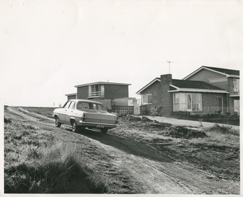
Photograph - Photograph, black and white, 23.05.1967
The photograph shows a RDNS Sister driving her RDNS car along a dirt road to reach a patient to administer nursing care. It shows the typical conditions of the roads the RDNS trained nurses encountered in some districts. The photograph also depicts an Australian made Holden car of the mid 1960s Melbourne District Nursing Society, later Royal District Nursing Service (RDNS) has had various modes of transport over the last 130 years. At first their Trained nurses (Nurses) walked the streets and lane ways amid the slums of central Melbourne. As the Society expanded bicycles, public transport, District cars, the use of a Motor Auxiliary, the Trained nurses (Sisters) own cars, and even a motorcycle were used, and all these forms were intermingled until RDNS had its own fleet of vehicles. By 2009 there were 598 cars in the fleet and the Sisters travelled 9 million 200,000 kilometres – this is equivalent to 12 trips to the moon and back. The Trained nurses of the Melbourne District Nursing Society (MDNS), later known as Royal District Nursing Service (RDNS), visited patients in their home and gave best practice care in many fields of nursing, and to people of many cultures, throughout its 130 years of expansion. Initial visits not only assessed the specific nursing situation but the situation as a whole. Their patients ranged in age from babes, children, adults to the elderly and referrals were taken from Hospitals, General Practitioners and allied Health facilities. Some of the care the Sisters provided is as follows: – Post-Natal care given to mother and babe, Wound Care following various types of surgery, accidents, burns, cancer, leg ulcers etc. Supervising and teaching Diabetic Care, including teaching and supervising people with Diabetes to administer their own Insulin, and administering Insulin to those unable to give their own injections. Administering other injections and setting up weekly medication boxes. The Sisters performed Catheterizations on adults suffering from conditions such as Quadriplegia, Paraplegia, Multiple Sclerosis (MS), Motor Neurone Disease (MND) and Guillan-Barre Syndrome, and when required at school on children for e.g. those with Spina Bifida. The Sisters visited those requiring Cystic Fibrosis support and care; those requiring Haemo-Oncology care, including visiting children at school; those requiring Home Enteral Feeding care, and those requiring IV therapy at home and home Dialysis. Palliative Care was given including pain relief with the use of syringe drivers, personal care as needed, and advice and support to both patient and family. The Sisters provided Stoma management to those needing Urostomy, Ileostomy and Colostomy care and those requiring Continence care. HIV/AIDS nursing care was provided; visits to Homeless Persons were made. Personal care was given to patients ranging in age and with varying mobility problems, such as those with MS, MND, Guillan-Barre Syndrome, Poliomyelistis, Quadriplegia, Paraplegia, Acquired Brain Injury, to those following a Cerebrovascular Accident (Stroke), those with severe Arthritis and those with a form of Dementia. When necessary the elderly were assisted with personal care and advice given on safety factors with the use of hand rails, bath or shower seats, and hand showers. Rehabilitation with an aim towards independence remained at the forefront of the Sister’s minds and when possible using aids and instruction on safe techniques enabled the person to become fully independent. All care included giving advice and support to the patient and their Carers. The Sisters liaised with the persons Doctor, Hospital and allied Health personal when necessary.In the centre of this black and white photograph is a Royal District Nursing Service, (RDNS), Sister at the wheel of her RDNS Holden car, which has a black rear Victorian number plate with 'JPH - 516' written in white letters. Through the back window you can see part of the Sister's uniform and her peaked hat worn over her short curled hair. Her left hand is on the upper part of the steering wheel. The dirt road on which she is travelling has mud and some grass tufts either side of it. On the right of the car is a hip roof brick house which has a single storey front area with attached two storey section at the rear. A short open Besser brick fence, with a white wooden gate, is seen running from the front of the property to the house, and beyond this a clothes line and shed. Beyond this, part of a tall paling fence is seen from the front of the property to the shed. The top section of the next brick house is seen beyond the fence; it has a white railed veranda along part of it and the house has a flat roof.Photographers stamp. Quote No. GE 90rdns, royal district nursing service, rdns transport, rdns patient care -
 Federation University Herbarium
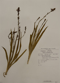
Plant specimen, Alexander Clifford Beauglehole, Caesia parviflora var. vittata (R.Br.) R.J.F.Hend, 17/10/1978
Cliff Beauglehole was an orchardist at Portland, Victoria, who throughout hislife took an intense interest in the plants of Victoria. Over his lifetime he collected 90,000 plant specimens as part of a comprehensive study of Victoria's plants and wrote thirteen books under the heading The Distribution and Conservation of Vascular Plants in Victoria, each written to cover the 13 study areas of the Victorian and Conservation Council.A mounted botanical specimen.beauglehole herbarium, herbarium specimen, botany, herbarium, plant science, plant specimen, field naturalists' club ballarat, federation university herbarium, caesia parviflora var. vittata, blue grass-lily, asphodelaceae -
 Melton City Libraries
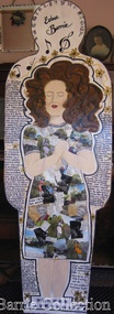
Artwork, other, Edna Barrie: Collo Character, 2001
Part of the PeopleScape Federation Celebration An initiative of the National Council for the Centenary of Federation, celebrating the contribution of Australians to their community and country. The final event of the year long celebrations, held in Canberra, the city that Federation created. The public art installation told the individual stories of Australians from all walks of life, from those living and those who had died. The massive sculpture depicted the life of the nation. The figures were nominated and decorated by individuals, groups of individuals and organisations from across Australia with every state, territory and region represented with approx. half from regional and the remote areas of Australia. The sculpture was installed in alphabtical order, each with a plaque at its base outlining the individual's achivement. The yellow colour of the figures against the green grass represented the colours of Australia.Close ups of Edna's Collo Characterlocal identities -
 Federation University Herbarium
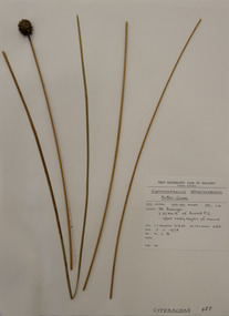
Plant specimen, Alexander Clifford Beauglehole, Gymnoschoenus sphaerocephalus (R.Br.) Hook, 5/11/1978
Cliff Beauglehole was an orchardist at Portland, Victoria, who throughout hislife took an intense interest in the plants of Victoria. Over his lifetime he collected 90,000 plant specimens as part of a comprehensive study of Victoria's plants and wrote thirteen books under the heading The Distribution and Conservation of Vascular Plants in Victoria, each written to cover the 13 study areas of the Victorian and Conservation Council.A mounted botanical specimen.beauglehole herbarium, herbarium specimen, botany, herbarium, plant science, plant specimen, field naturalists' club ballarat, federation university herbarium, gymnoschoenus sphaerocephalus, button grass, cyperaceae -
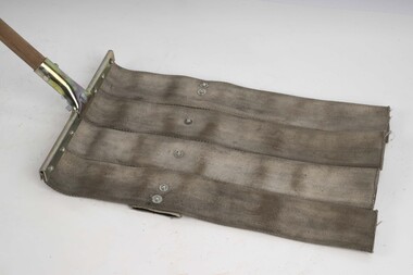
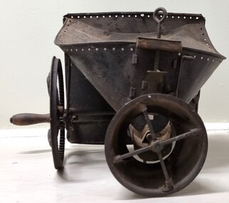 Wodonga & District Historical Society Inc
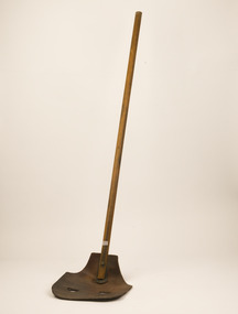
Functional object - Hand operated seed broadcaster
Seed broadcaster were used to distribute seed across a small area or to fill in patches where seeding has been missed. This method does not ensure a uniform distribution of seeds unless the person using the machine walks at a very measured pace. It also requires a lot of time and manual labour if used in larger areas. It was most used for planting cover crops, grains, grasses and similar plants that do not need to be in neat rows. The hand-crank broadcast seed spreader was invented in 1868 by Samuel S. Speicher (aka. Spyker) in Indiana, USA. By 1955 new developments included the invention of a seed broadcaster on wheels and these smaller spreaders started to disappear.This item is representative of agricultural machinery used on a local, national and international level in the late 19th and early 20th century.A metal hand seed broadcaster. A hopper at the top was the receptacle for seed. The wheel with a handle on the side when turned drives the cogs attached to an axle. This action rotates the attached spindle with blades to propel seed out the front of the broadcaster. The broadcaster would have had a shoulder strap and a bag of seed would have been added to the hopper and secured with twine through the holes around the top.agricultural tools, farm machinery -
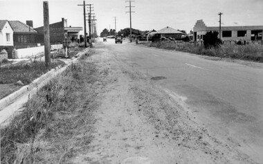 City of Kingston
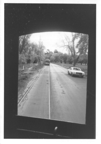
Photograph - Black and white, c. 1950
While the road is sealed, there is evidence of potholes that have been filled, and the wide, gravel shoulder has long grass running into the gutter of the nature strip. On the other side of the road, extremely long grass can be seen growing on the side of the road. There is a truck visible on the road, which indicates the rural nature of the Cheltenham community in the 1950s.This image is one of many in the collections that focuses on the railway or roads. The development of roads and the railway was crucial to the ongoing development of the area. Black and white photograph of the intersection of Warrigal and Centre Dandenong roads, Cheltenham. On the left hand side is a small sign warning of a cross roads intersection. Housing and shops line the road.Handwritten in blue ink on reverse: 219 Handwritten in red ink on reverse: 80%cheltenham, roads, suburbs -
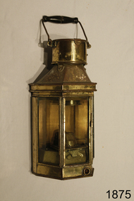 Flagstaff Hill Maritime Museum and Village
Functional object - Lamp, 1886
This late 19th century maritime lamp is an example of lighting on ships, wharfs and other outside areas around docks and shipyards as well as on vessels.Lamp; grass and glass, with flat metal back and three glass windows. Has metal handle and wood hand piece. A brass lug on the back makes provision for attaching to a socket on a wall. The chimney lid flips upwards. The right-side door frame has a sliding latch, and the edge behind has a sliding panel to allow air flow. Made in Birmingham by Alderson & Gyde Limited in 1886."Alderson & Gyde LTD 1886 Birmingham" flagstaff hill, warrnambool, shipwreck coast, flagstaff hill maritime museum, maritime museum, maritime village, alderson & gyde ltd, birmingham, lamp, lantern, wall lamp, marine equipment, maritime light, wall light, 1886, ship lighting -
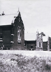 The Beechworth Burke Museum
Photograph, c. 1900
This black and white photograph shows the front view of the Ovens Benevolent Home with one person sitting on a bench seat against the nearest part of the building and another person walking on the grass. This photo is estimated to have been taken in the early 1900’s when the Ovens Benevolent home would have still been fairly contemporary. According to Woods (p. 121) in the 1860’s the government spent considerable sums to establish several public buildings such as the Benevolent Asylum, the Hospital and Insane Asylum to support those in need of care in the area directly after the Indigo gold rush which had left Beechworth, a fairly remote regional and newly formed township (Gold was first discovered in Beechworth in 1852) with a number of infirm and destitute people in its wake and which due to the support and establishment of these facilities ‘made Beechworth a significant social welfare centre in Victoria’ (Woods, p. 121). Originally named the Benevolent Asylum, the building was renamed as The Ovens Benevolent Asylum in 1935 and again to The Ovens and Murray Home in 1954. The building construction began in 1862 and was unique in its features of Flemish Gothic Revival style which utilised red brick and granite, ‘the main facade is dominated by four curved, Flemish gable ends, […] incorporates paired windows of pointed Gothic form and dark brick diaperwork patterning. The adjacent J. A. Wallace Wing of 1899 was designed by Donald Fiddes as a separate building. Also constructed of red brick, Fiddes adopted a conservative approach, designing a simple domestic scale building with central projecting gable porch and flanking bull nosed verandahs.’ (https://vhd.heritagecouncil.vic.gov.au/places/118). Initially established to provide housing and care for aged, orphaned or widowed members of the population, over time the Ovens Benevolent Home focused more on the age care responsibility which functioned as such up until 2005.The Ovens Benevolent Home is significance due to its association with the early development of Beechworth. It shows the civic, social welfare development that took place in the town after the peak of the gold rush which helps to establish the character of the community being built at the time and their cultural values at play. This photograph also clearly shows the early functioning landscape of that building and its purpose as well as the significant elements of its aesthetic significance and unique and striking architectural forms of the building.Black and white rectangular photograph [copy from slide]Reverse: / 7588 /housing and care, aged care, donald fiddes, ovens benevolent home, flemish gable, brick diaperwork, photograph, black and white photograph, public building, benevolent asylum, indigo gold rush, beechworth, the ovens and murray home -
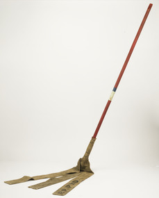 Forests Commission Retired Personnel Association (FCRPA)
Fire Beater - Canvas, c 1930s
Bushfire perimeter rather than bushfire area is the main control problem for firefighters on the ground. A conundrum rapidly compounded by spot fires. A small 5 ha fire can be nearly 1 km around the perimeter. That's a long way to build a control line by hand in rough bush. Dry firefighting techniques by hand were mostly confined to “knocking down” or “beating out” the flames, as well as "digging out". Digging or raking a “mineral earth” trail down to bare dirt proved most effective in forest fuels which, unlike grass, tend to retain heat and smoulder. Early tools were whatever happened to be close at hand. They were simple and primitive and included shovels, slashers, axes, hoes, beaters and rakes. A cut branch to beat the flames was often the only thing available. Farming and logging tools, developed over centuries of manual labour, and readily available at local hardware stores came into use, but little thought was given to size, weight, and balance. This canvas hose beater was based on a century-old design which used lengths of canvas fire hose rivetted together and lashed with wire to a broom handle. The hose was be soaked in water to improve its effectiveness. If the flames were more than a metre or so the user was generally not able to get close enough to extinguish the fire It's recommend that users lift no more than above knee height to conserve energy and let the beater to the work. For years foresters experimented with combination tools. In about 1952 fire beaters and other implements were being replaced with Rakuts and later RakehoesEarly firefighting toolBushfire beater - Canvas with wooden handleR P PWD (Public Works Department) The handle has painted markings which indicate which FCV District it belonged to.bushfire, forests commission victoria (fcv) -
 Forests Commission Retired Personnel Association (FCRPA)
Fire Beater - Leather, c 1940s
Bushfire perimeter rather than bushfire area is the main control problem for firefighters on the ground. A conundrum rapidly compounded by spot fires. A small 5 ha fire can be nearly 1 km around the perimeter. That's a long way to build a control line by hand in rough bush. Dry firefighting techniques by hand were mostly confined to “knocking down” or “beating out” the flames, as well as "digging out". Digging or raking a “mineral earth” trail down to bare dirt proved most effective in forest fuels which, unlike grass, tend to retain heat and smoulder. Early tools were whatever happened to be close at hand. They were simple and primitive and included shovels, slashers, axes, hoes, beaters and rakes. A cut branch to beat the flames was often the only thing available. Farming and logging tools, developed over centuries of manual labour, and readily available at local hardware stores came into use, but little thought was given to size, weight, and balance. This leather beater was based on a century-old stockman's design which used green cow hide leather lashed to a broom handle. It's recommend that users lift no more than above knee height to conserve energy and let the beater to the work. For years foresters experimented with combination tools. In about 1952 fire beaters and other implements were being replaced with Rakuts and later RakehoesEarly firefighting toolBushfire beater - Leather with wooden handlebushfire, forests commission victoria (fcv) -
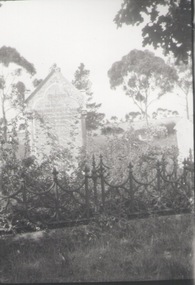 Sunbury Family History and Heritage Society Inc.
Photograph, C1920s
The grave is in Sunbury Cemetery and belongs to Margaret Baker, who was an inmate at the former Sunbury Asylum. See further details on P0686.A black and white photograph of a headstone in a cemetery. The grave is surrounded with a low decorative iron fence. A lot of the surrounding area is overgrown with weeds and grasses.baker, margaret., sunbury, sunbury cemetery -
 Ballarat Tramway Museum
Photograph - View of Wendouree Parade north end, c1977
Photograph from the window of a tram (possibly No. 28) looking along the BTPS track from St Aidans Drive with another tramcar in the distance. Shows the roadside nature of gardens area at the time - long grass and before the construction of a gutter and paths. Possibly taken at the same time as item 9642.Yields information about Wendouree Parade near St Aidans Drive.Black and white print on Kodak paper.tramcars, trams, btps, tram 26, tram 28, st aidans drive, wendouree parade -
 Eltham District Historical Society Inc
Photograph - Digital Photograph, Alan King, Cameron family graves, Kangaroo Ground Cemetery, Eltham-Yarra Glen Road, Kangaroo Ground, 28 January 2008
Six year old Judith Furphy was the first person known to have been buried at Kangaroo Ground Cemetery in May 1851. The cemetery is situated on an ancient river bed with exposed Nillumbik sands. The rest of the district is formed from black volcanic soil which was hard to dig. According to local historian Mick Woiwod (deceased) the site may have been a burial ground for the local Wurundjeri people as the exposed softer sands were always their prefered camping sites. The Hon. Ewen Hugh Cameron who lived at Pigeon Bank and was the Member for Evelyn for 40 years (1874-1914) was buried here in 1915. Published: Nillumbik Now and Then / Marguerite Marshall 2008; photographs Alan King with Marguerite Marshall.; p39 The Wurundjeri people might have buried their dead on the site of the Kangaroo Ground Cemetery, according to local historian Mick Woiwod. Kangaroo Ground was a premier hunting ground, but camping on the black volcanic soil would have been uncomfortable. Unlike most of Kangaroo Ground, its cemetery, on an ancient river bed, comprises a rare exposure of Nillumbik sands – always the preferred campsite for Aboriginal people. The cemetery area is the only place where the soil was soft enough to dig a grave easily.1 Six-year-old Judith Furphy was the first person known to have been laid to rest at the Kangaroo Ground Cemetery. She died on May 17, 1851, from a chill caught by resting on wet grass. Local Andrew Ross wrote ‘..no public burying place existed nearer than Melbourne. The case being considered urgent, a general meeting of the settlers took place on the evening of the 17th……. The result was the selection of unoccupied crown land …….which was subsequently granted by Government for a public cemetery.’2 Judith was buried the next day on May 18. Her grave was marked by the trustees with a plaque, which unfortunately states nine years old, when she was probably only six. Judith came from an illustrious family. Her brother, Joseph, was the author of Such is Life and other works. Another brother, John, developed and manufactured the famous Furphy water cart, which distributed water to World War One soldiers along with the latest rumours. Hence the name Furphy entered the Australian idiom, as synonymous with ‘rumour’. Judith’s father Samuel helped build the first Kangaroo Ground church school. Inside, near the entrance of the cemetery, on Yarra Glen Road, stand a rotunda and a water tank. Occasional benches invite mourners to pause and remember. The gate with wrought iron and brick supports, bears the inscription ‘Erected by Sir Ewen and Lady Cameron in memory of their daughter, Flora Margaret’. These are only two of the famous people connected with this cemetery. The Hon. Ewen Hugh Cameron JP and MLA from 1874 to1914, who lived at Pigeon Bank, Warrandyte Road, was buried here in 1915. Unrelated, but with the same name, was Sir Ewen Cameron who had been Minister for Health and was laid to rest there in 1964. Sir Herbert Gepp, a leading industrialist and the former owner of Garden Hill, at Yarra Glen Road, was buried there in 1954.3 Many of the more imposing tombstones belong to the earlier graves. Unfortunately bushfires have cracked several. But this adds to the melancholy attractiveness of the cemetery, graced by some beautiful eucalypts, cypress and pines. Early pioneering families represented at the cemetery include Armstrong, Barr, Bell, Harkness, Jardine, Johnston, Rogerson, Stevenson, Thomson and Walters. Armstrong and Bell were among the first families to come to the district and Stevenson owned the district’s first sheep station. It took in much of present day Christmas Hills, which was the name he gave his sheep station. Harkness was the first to suggest a Kangaroo Ground school be built, and one of the first to suggest establishing the Eltham District Road Board. Many of these families leased pastoral land before the mid-century and bought land when it came on sale in 1849. In the cemetery’s early days sections were devoted to the major Christian denominations (mainly the Protestant) and one section was set aside for ‘other’ or ‘non-believers’. However in modern times burial plots have not been placed in areas according to religious beliefs.This collection of almost 130 photos about places and people within the Shire of Nillumbik, an urban and rural municipality in Melbourne's north, contributes to an understanding of the history of the Shire. Published in 2008 immediately prior to the Black Saturday bushfires of February 7, 2009, it documents sites that were impacted, and in some cases destroyed by the fires. It includes photographs taken especially for the publication, creating a unique time capsule representing the Shire in the early 21st century. It remains the most recent comprehenesive publication devoted to the Shire's history connecting local residents to the past. nillumbik now and then (marshall-king) collection, kangaroo ground, eltham-yarra glen road, agnes bell cameron, agnes cameron (nee bell), cameron family, edward aubrey haughton, eugene cameron, evelyn florence cameron, ewen hugh cameron, gravestones, jane armstrong, jane bell, jessie agnes haughton (nee cameron), jessie cameron, john donald cameron, kangaroo ground cemetery, neville cameron, simon armstrong, vera cameron, william bell armstrong, wurundjeri -
 Eltham District Historical Society Inc
Photograph - Digital Photograph, Alan King, Kinglake National Park, 27 March 2008
Fern gullies around Jehosaphat Gully Covered under National Estate. Published: Nillumbik Now and Then / Marguerite Marshall 2008; photographs Alan King with Marguerite Marshall.; p125 The magnificent Kinglake National Park, fringing Nillumbik’s north, is the largest national park close to Melbourne. Thanks to the vision and hard work of a band of local people, the park was created from what was rapidly becoming degraded land. Seeing a threat to Kinglake’s indigenous flora and fauna, several prominent local people campaigned for a national park, which was established in 1928.1 Since then, the park has grown through donations and acquisitions of land, from around 13,800 acres of land (5585ha) to 22,360 hectares. The Sugarloaf and Everard Blocks – of almost 8000 hectares – stand in Nillumbik and the park extends into Mitchell and Murrundindi Shires and the City of Whittlesea. Mt Everard commemorates William Hugh Everard, State member for Evelyn when the park was established. Before 1928, European settlers had degraded the Kinglake area, which was named after the celebrated English author and lawyer, Alexander William Kinglake. Remains of gold shafts and diggings in the park are reminders of Kinglake’s first settlers, who hoped to strike it rich at the gold diggings. But like other gold fields in this shire, they proved not very lucrative and soon timber cutting replaced mining in importance. However, before long, the accessible timber supply ran out, so in the 1920s agriculture took over – particularly potatoes and berry fruits – which involved large-scale clearing.2 The park’s instigator was retired Melbourne University Professor of Music, William Laver.3 As chair of the Kinglake Progress Association he began negotiations to have crown lands on the southern scarp of the Great Dividing Range reserved as a national park. Even before the park was proclaimed, from 1927, KPA members cut tracks to the major scenic points. Professor Laver was one of several people who gave land for the park, donating around 50 acres (20ha), including the Jehosaphat Gully.4 Laver chaired the park’s first Committee of Management, which raised money to employ a ranger and provide facilities, including tracks and roads for fire protection vehicles, toilets and shelters. The committee charged fees for firewood collection, some grazing of livestock, and visitor entrance, and obtained small State Government and Eltham Shire grants. In 1957 the State Government provided revenue for national parks. Then, in 1975, the State Government took over the management and the Committee of Management became an advisory committee, which disbanded in 1978. Originally, the park covered crown land in the Shires of Eltham and Whittlesea; then Wombelano Falls in Yea and other areas were added. In 1970 the park extended into the Shires of Eltham, Healesville, Whittlesea and Yea.5 Bush fires have been an ongoing problem. In 1939 hundreds of eucalypts and acacias had to be sown around the Jehosaphat Gully to rejuvenate the forest. To manage bushfires, the Committee of Management, then the State Government, worked closely with the Forestry Commission, shire councils and local fire brigades. Early national parks focussed on recreation. But by the 1980s, conservation, education and scientific research became more important, playing a vital role in preserving representative samples of the natural environment. Each year many thousands of people use the park’s extensive network of walking tracks amongst the protected plant and animal life as well as camping, cycling and horse riding. The park, along the slopes of the Great Dividing Range, has lookouts revealing magnificent views of the Melbourne skyline, Port Phillip Bay, the Yarra Valley and the You Yangs. Vegetation in the Masons Falls area includes messmate forest, Austral grass-trees, ferns and Hazel Pomaderris. In spring, orchids, lilies, everlasting daisies, correas, grevillea and heath appear. Around Jehosaphat Gully are wet and dry forest, fern gullies and banksia. Animal life includes wallabies, kangaroos, koalas, echidnas, possums, gliders and bandicoots. Male lyrebirds can be heard mimicking in the Jehosaphat Gully, particularly in the Everard Block in winter.This collection of almost 130 photos about places and people within the Shire of Nillumbik, an urban and rural municipality in Melbourne's north, contributes to an understanding of the history of the Shire. Published in 2008 immediately prior to the Black Saturday bushfires of February 7, 2009, it documents sites that were impacted, and in some cases destroyed by the fires. It includes photographs taken especially for the publication, creating a unique time capsule representing the Shire in the early 21st century. It remains the most recent comprehenesive publication devoted to the Shire's history connecting local residents to the past. nillumbik now and then (marshall-king) collection, kinglake national park, jehosaphat gully -
 Ringwood and District Historical Society
Document - Department of Lands and Survey, Wire Netting Branch, Melbourne, Victoria, Application for Vermin-Proof Fence Certificate - L.J. Mills vs John Collins, Grandview Grove, Ringwood, Victoria - 1939
Photocopied file of corresponence and documentation relating to a claim by L.J. Mills, Nurseryman, that adjoining property owner, J. Collins, Farmer, assists with replacement of a vermin proof wire netting dividing fence destroyed by 1939 bushfire. File includes 1939 and 1940 detailed property inspection reports by Vermin and Noxious Weeds Branch, Lands Department, Lilydale, describing land use in the area and signs of vermin activity. Application approved 18th April, 1940. Appeal lodged by Mr Collins disallowed in May, 1940. File closed June, 1940 with Departmental suggesion that Mr Mills consider further legal action through a Solicitor as fence had still not been wire-netted. TRANSCRIPTS: Vermin & Noxious Weeds Inspection Reports "19/9/1939 (To) Superintendent (Department of Lands and Survey, Melbourne) Re L.J. Mills application for Vermin Proof Fence. I called on Mr Mills yesterday 18th instant in connection with this matter. Mr Mills has a flower farm and claims that rabbits and hares are damaging his flowers. He showed me a bed of carnations which he stated were being damaged by rabbits. There was evidence of some leaves being nipped off, but I am unable to say whether this is due to rabbits or grubs. Very little if any real damage is being done. The property is netted on the east and south boundary and on half the north and west boundary. The surrounding country is undlating and fairly steep in places. The land to the east across Grandview Avenue (sic) is all planted out in old established orchards and well cultivated. Cleared grass land adjoins the south boundary and bush land adjoins the north and west boundaries. I walked over a large area surrounding Mr Mills land and never saw any rabbits or hares or any indications of rabbits. This locality is not rabbit infested and very little wire netting is being used. I do not consider that a vermin proof fence is necessary between these allotments. - Jas H Allison (Inspector, Vermin and Noxious Weeds Branch, Lands Department, Lilydale)." Follow up report following renewal of application for Certificate by Mr Mills, citing rabbits causing considerable damage to his flowers. He laid poison and obtained 9 carcases and stated that there is evidence of rabbit infestation from the adjoing land. "19/3/1940 (To) Mr Hannah (Superintendant, Department of Lands and Survey, Melbourne) Re L.J. Mills, Grandview Grove Ringwood, Lot 4 Grandview Estate Pt CG20 Ph of Warrandyte. I interviewed Mr Mills at his home on 15th inst. He showed me carcases of rabbits which he stated had been poisoned on his land. In places young plants had been nipped off apparently by rabbits. I made an inspection of adjoining properties and found one live burrow close to Mr Mills northern boundary. There were scratches and other evidence of rabbits on land north and west of Mr Mills property. In view of the present evidence of rabbits I consider that a vermin proof fence is now necessary to protect the flowers grown by Mr Mills. His land is netted on whole of east and south boundary and half way on west and north boundary. The adjoining land on west and north boundaries is owned by Mrs Linda Collins and John Collins resp of Brysons Road East Ringwood. - Jas H Allison (Inspector, Vermin and Noxious Weeds Branch, Lands Department, Lilydale)." -
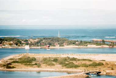 Lakes Entrance Historical Society
Photograph - Bullock Island, Scarce Keith, 1962
Date made May 1962Colour photograph of Bullock Island. It shows the causeway and raised bridge to the island, Cunninghame Arm, dwellings and jetty at hummocks, western pier of entrance, sandy area of island planted with grass. Taken prior to transfer of PWD to island, and before Pecks factory and Fishermens Co-Operative. Lakes Entrance Victoriaislands, waterways, land reclamation, fishing industry -
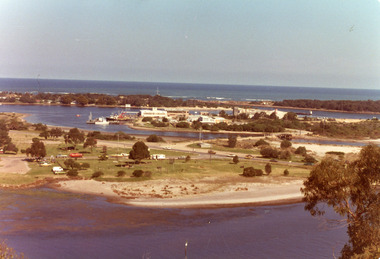 Lakes Entrance Historical Society
Photograph - Bullock Island, Holding George, 1975c
Colour photograph of Bullock Island showing Pecks fish processing factory Lakes Entrance Fishing Co-Operative, and PWD buildings, vehicles on picnic area of Marine Parade during one and only offshore power boat race. Spit opposite Club Hotel has grass and some bushes. Lakes Entrance Victoriaislands, land reclamation, waterways -
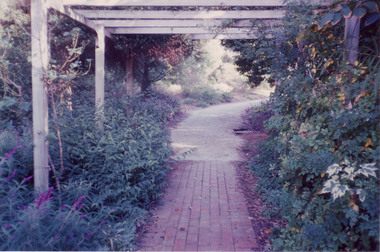
 Eltham District Historical Society Inc
Photograph - Digital Photograph, Alan King, Alistair Knox Park, Eltham, 2008
Alistair Knox Park, an oasis of peace and beauty. Covered under National Trust of Australia (Victoria) Landscape Significance and Heritage Overlay, Nillumbik Planning Scheme. Published: Nillumbik Now and Then / Marguerite Marshall 2008; photographs Alan King with Marguerite Marshall.; p173 It is hard to imagine that the Alistair Knox Park, an oasis of peace and beauty beside busy Main Road, Eltham, was once the township’s rubbish dump. It was only in the 1970s that the tip was transformed into this beautiful six hectare space, which later earned it a National Trust Landscape classification. Before its life as a dump, the area was used for small farms. Thanks largely to the foresight and efforts of local environmental builder Alistair Knox, the park was designed sympathetically with the character of the wider Eltham landscape. Then, appropriately, the park was named after Knox, who was an Eltham Shire Councillor from 1971 to 1975 and Shire President in 1975. The park designers were four major forces in the urban bush landscape garden –Knox, landscape designer Gordon Ford, artist Peter Glass and landscaper Ivan Stranger. The National Trust citation for the park, originally called Eltham Town Park, includes the Eltham railway trestle bridge and the Shillinglaw Cottage. The citation states ‘the semi-natural setting of the parkland provides a landscape which is evocative of the history of the area’. Manna Gums (Eucalyptus viminalis) and Candlebarks (Eucalyptus rubida) are significant features. Most of the park’s construction was directed by Bob Grant, Superintendent of the Parks and Gardens Department for the Eltham Shire Council. First plantings occurred in Arbour Week in 1973, then the lake and botanic area were completed in 1975, with Federal Government funding, and the toilet block in 1978. Bounded by the Eltham railway line, Panther Place, Main Road, Bridge and Susan Streets, the park is in a valley about a kilometre wide overlooked by steep hills at the east and west. The Diamond Creek flows through it and the picturesque historic timber trestle railway bridge edges the north. Informal plantings of Australian indigenous and native species in open and undulating grassed settings blend with the natural landscape of the Diamond Creek to the west. The bush-style plants, particularly around the creek, balance with open lawns, paths and a cascade flowing from a small lake to another below. A footbridge over the creek leads to the park’s west. The park includes an adventure playground and barbecue areas. The park stands on part of the land bought from the Crown in 1851 by Josiah Holloway, who subdivided it into allotments and which he called Little Eltham. Most of the land was subdivided into residential lots, but the creek valley, on which the park stands, was subdivided into farm-size lots, used mainly for orchards and grazing. One of the earliest owners was John Hicks Petty, who in 1874 bought a plot from Holloway. Other families who owned properties in that area, included Rees, Clark, Waterfall, Graham, Hill and Morant. In 1901 the railway was built through the area. Jock Read, an Eltham resident since around 1920, remembers several farms in the 1920s and ’30s that occupied the site of today’s park. A poultry farm, which extended from present day Panther Place, was owned by the Gahan family. Next to that farm was another for grazing cattle owned by Jack Carrucan. Beside this was land owned by John Lyon. A doctor lived beside this, and at the north-west corner of Bridge Street and Main Road stood a memorial to the soldiers who died in World War One, which was later moved to the RSL site. Mr Read also remembers other farms and orchards west of the creek In the early 1960s the Eltham Council began buying these farms and in the late 1960s turned the areas east of the Diamond Creek into a garbage tip. When this was filled above the creek’s flood plain, the tip was moved to the west of the creek.This collection of almost 130 photos about places and people within the Shire of Nillumbik, an urban and rural municipality in Melbourne's north, contributes to an understanding of the history of the Shire. Published in 2008 immediately prior to the Black Saturday bushfires of February 7, 2009, it documents sites that were impacted, and in some cases destroyed by the fires. It includes photographs taken especially for the publication, creating a unique time capsule representing the Shire in the early 21st century. It remains the most recent comprehenesive publication devoted to the Shire's history connecting local residents to the past. nillumbik now and then (marshall-king) collection, alistair knox park, eltham -
 Department of Energy, Environment and Climate Action
Rakehoe (McLeod Tool)
Bushfire perimeter rather than bushfire area is the main control problem for firefighters on the ground. A conundrum rapidly compounded by spot fires. A small 5 ha fire can be nearly 1 km around the perimeter. That's a long way to build a control line by hand in rough bush. Dry firefighting techniques by hand were mostly confined to “knocking down” or “beating out” the flames, as well as "digging out". Digging or raking a “mineral earth” trail down to bare dirt proved most effective in forest fuels which, unlike grass, tend to retain heat and smoulder. Early tools were whatever happened to be close at hand. They were simple and primitive and included shovels, slashers, axes, hoes, beaters and rakes. A cut branch to beat the flames was often the only thing available. Farming and logging tools, developed over centuries of manual labour, and readily available at local hardware stores came into use, but little thought was given to size, weight, and balance. For years foresters experimented with combination tools. In about 1952 fire beaters and other implements were being replaced with Rakuts. However, its believed the now common Rakehoe is an Australian variation of the American McLeod Tool which was developed in 1905 by forest ranger Malcolm McLeod of the Sierra National Forest. The late Athol Hodgson advised that predecessors, Reg Torbet who had been the Chief Fire Officer for the Forests Commission from 1948-1956, along with his QLD counterpart Clive Price, went in late 1951 as Australian delegates on a 10 week fire study tour of Nth America organised by the United Nations. They came back with a couple of McLeod tools from Canada. Cam MacLeod (different spelling) had been the Head of Fire Research for the Canadian Forest Service at the time and had supplied them. The tools were ideal for deciduous forests in the eastern provinces and Clive arranged to have them manufactured in QLD. The Rakho, as it was then spelled, was first issued to FCV crews 65 years ago in 1955-56. The American Pulaski had been trialled, but never found favour with Australian firefighters.Rakhoeforests commission victoria (fcv), hand tools, forest harvesting, bushfire -
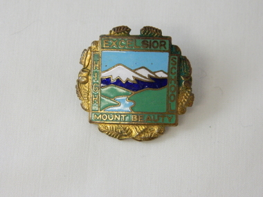 Kiewa Valley Historical Society
Badge Brass - Mt Beauty High School, circa 1970
Schools of this era were very proud of their identity. This was particularly so in country based ones. Schools in isolated or semi isolated regions provided social cohesion and pride and community involvement that was not so inherent in schools located in larger cities. The exception here being the Greater Public Schools. Mrs Beverly Johnson nee Davis designed the school badge.This badge was worn by a local girl, who has the spirit shown by many pupils from the Mount Beauty High School that the identity of belonging to a Kiewa Valley High School is a treasured part of life for them in this regional area. Mount Beauty High School badge made of brass. The front is coloured enamel depicting a scene of sky, mountains, grass and river. It is surrounded on four sides by the words Excelsior, Mount Beauty, High, School. The outside edges are decorated with gold colored fernsExcelsior, School, Mount Beauty, High On flip side K. G. Luke Melb.school badge, hat, lapel badge, high school memorabilia, brass badge -
 Department of Energy, Environment and Climate Action
Fire beater (canvas)
Bushfire perimeter rather than bushfire area is the main control problem for firefighters on the ground. A conundrum rapidly compounded by spot fires. A small 5 ha fire can be nearly 1 km around the perimeter. That's a long way to build a control line by hand in rough bush. Dry firefighting techniques by hand were mostly confined to “knocking down” or “beating out” the flames, as well as "digging out". Digging or raking a “mineral earth” trail down to bare dirt proved most effective in forest fuels which, unlike grass, tend to retain heat and smoulder. Early tools were whatever happened to be close at hand. They were simple and primitive and included shovels, slashers, axes, hoes, beaters and rakes. A cut branch to beat the flames was often the only thing available. Farming and logging tools, developed over centuries of manual labour, and readily available at local hardware stores came into use, but little thought was given to size, weight, and balance. For years foresters experimented with combination tools. In about 1952 fire beaters and other implements were being replaced with Rakuts. However, its believed the now common Rakehoe is an Australian variation of the American McLeod Tool which was developed in 1905 by forest ranger Malcolm McLeod of the Sierra National Forest. The late Athol Hodgson advised that predecessors, Reg Torbet who had been the Chief Fire Officer for the Forests Commission from 1948-1956, along with his QLD counterpart Clive Price, went in late 1951 as Australian delegates on a 10 week fire study tour of Nth America organised by the United Nations. They came back with a couple of McLeod tools from Canada. Cam MacLeod (different spelling) had been the Head of Fire Research for the Canadian Forest Service at the time and had supplied them. The tools were ideal for deciduous forests in the eastern provinces and Clive arranged to have them manufactured in QLD. The Rakho, as it was then spelled, was first issued to FCV crews 65 years ago in 1955-56. The American Pulaski had been trialled, but never found favour with Australian firefighters.Fire Beater (canvas) 1930s designforests commission victoria (fcv), hand tools, forest harvesting, bushfire -
 University of Melbourne, Burnley Campus Archives
Photograph - Colour print, Stuart Miller, Native Garden and Plant Trials, 1990-2005
Colour photographs. (1) "Entrance to Rainforest Garden from Rose Garden." (2) "The Native Garden." "Please return to Stuart Miller." The Robert Boyle Ponds. (3) View of Kath Deary Garden to James Hitchmough Grasslands. (4) Cultivating site with tractor in (5-12) Trialling native grasses in the Field Station. (13) Kath Deary Garden. (14-15, 17-19) James Hitchmough Grasslands, Native grasses. Planting of flowering herbs commenced 1992. (16) "Native Area 2005." James Hitchmough Grasslands native grasses. rainforest garden, native garden, stuart miller, robert boyle pond, kath deary garden, james hitchmough grasslands, tractor, field station, native grasses, grass trials, entrance from rose garden -
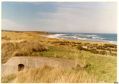 Flagstaff Hill Maritime Museum and Village
Photograph - Historical, Flagstaff Hill, Warrnambool Garrison Fortifications looking towards the Moyjil (Point Ritchie), 1970s
The photograph shows the location of the concrete, horseshoe shaped gun emplacement erected for the cannons. It is part of the Historic Precinct on Flagstaff Hill. The area was accessed either through the space between the Lighthouses (through the cottage grounds) or a service entrance, past the iron huts used by the Lands Department. This photograph, a print, is one of a set of five that show the site of Flagstaff Hill. It is presumed to have been taken by John Lindsay, Founding Director of Flagstaff Hill Maritime Museum and Village. One of the photographs in the set has the pencil inscription "Photo J Lindsay". It was taken in the early 1970s during the initial stages of the development of Flagstaff Hill as a Museum and Maritime Village. The photographs belonged to the donor's grandparents, who lived in the Warrnambool district of Allansford/Naringal. The photograph is a record of the site and surrounds of Flagstaff Hill Maritime Museum and Village before its development and opening in 1975. It shows the east side of the Surfside Holiday Park in its earlier days. The photograph is significant for recording the location and condition of the original concrete cannon emplacement on the Hill.Coloured photograph, glassy print, one of a set of five. Photograph shows the original site of one of the gun emplacements for the cannons, cannons Historical, looking towards the Moyjil, ,Point Ritchie and overlooking Lady Bay, Warrnambool. The horseshoe shaped concrete gun emplacement is in the foreground on the grassed slopes overlooking the Bay. The site and ablution block of the Surfside Holiday Park is centre right. The left shows the sore of Lady Bay with the cliffs of the Southern Ocean in the distance. The photograph's paper has the printer's watermark on the back. The early 1970s scene is presumed to have been photographed by John Lindsay, Warrnambool.Label on the back: "FIRST GUN EMPLACEMENT LOOKING TOWARDS THE HOPKINS / This is the original site of one of the cannons overlooking the Bay. Access to this area could be between the light-houses (throught the cottage grounds), or a service entrance - past the iron huts used by Lands Department."flagstaff hill, flagstaff hill maritime museum and village, warrnambool, maritime museum, maritime village, great ocean road, shipwreck coast, 1970s, photograph, gun emplacement, surfside holiday park, lady bay, hopkins river, flagstaff hill site, john lindsay, concrete gun emplacement, cannon emplacement, original emplacement -
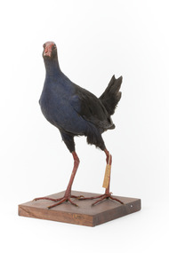 The Beechworth Burke Museum
Animal specimen - Australasian Swamphen, Trustees of the Australian Museum, 1860-1880
The Australasian swamphen is a visually striking and socially complex bird found across Oceania. It can be found in eastern Indonesia (specifically the Moluccas, Aru, and Kai Islands), Papua New Guinea, New Zealand, and Australia. As a member of the rail family (Rallidae), it belongs to the diverse order Gruiformes, which also includes cranes and other rail species. Like other rails, it possesses relatively short wings and a strong, elongated bill, both adaptations suited to its semi-aquatic wetland habitat. This swamphen is easily identified by its deep blue-purple plumage, prominent red frontal shield, and sturdy red legs. It primarily inhabits swamps, marshes, and other wet lowland areas, though its range has expanded to include pastures, roadsides, and farmland due to significant landscape modifications over the past 150 years. Unlike many wetland birds, it is highly adaptable and thrives in both natural and human-altered environments. Its diet is similarly flexible, consisting mostly of plant material such as grass stems, shoots, and leaves, but also including invertebrates and, on occasion, the young of other bird species. This specimen was misidentified as a Purple Swamphen in original catalogue records and is part of a collection of almost 200 animal specimens that were originally acquired as skins from various institutions across Australia, including the Australian Museum in Sydney and the National Museum of Victoria (known as Museums Victoria since 1983), as well as individuals such as amateur anthropologist Reynell Eveleigh Johns between 1860-1880. These skins were then mounted by members of the Burke Museum Committee and put-on display in the formal space of the Museum’s original exhibition hall where they continue to be on display. This display of taxidermy mounts initially served to instruct visitors to the Burke Museum of the natural world around them, today it serves as an insight into the collecting habits of the 19th century.This specimen is part of a significant and rare taxidermy mount collection in the Burke Museum. This collection is scientifically and culturally important for reminding us of how science continues to shape our understanding of the modern world. They demonstrate a capacity to hold evidence of how Australia’s fauna history existed in the past and are potentially important for future environmental research. This collection continues to be on display in the Museum and has become a key part to interpreting the collecting habits of the 19th century.This taxidermy specimen is of a Australasian swamphen which is mounted standing on a wooden platform and has a paper identification tag tied to its upper left leg. The specimen has dark colouring on its back and head with a purple-blue coloured neck, breast and belly. The bill is oversized and is orange/red which is the same colour as the frontal shield on the bird's face. The eyes are made from a red and black glass and the legs of this specimen are orange. The legs are elongated and the toes also long and unwebbed. 17e. / Purple Gallinule / Catalogue Page 35 / taxidermy mount, taxidermy, animalia, burke museum, beechworth, australian museum, skin, reynell eveleigh johns, bird, australian birds, swamphen, moorhen, purple bird, hen, purple swamphen, water bird -
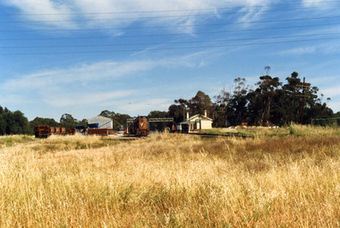 Charlton Golden Grains Museum Inc
Photograph, Charlton Shire, Charlton Railway Station c. 1987, c.1987
... it. There is a large area of high grass in the foreground and six electricity... it. There is a large area of high grass in the foreground and six electricity ...Charlton Railway Station was established in 1882 and closed down in the late 1970s.Colour photograph of the disused Charlton Railway Station. On the right, there is a small cream and green weatherboard building with a large verandah. There is a train engine and trucks in the middle of the photo and some other trucks to the left. There is a large corrugated iron shed and a small dark grey crane behind it. There is a large area of high grass in the foreground and six electricity wires through the top of the photo.transport, railway station, charlton -
 University of Melbourne, Burnley Campus Archives
Album - Black and white and sepia prints, Gardens Other Than Burnley, 1890-1920
Identification and information on reverse of some photographs given by Georgina Whitehead (Tel-9572 1225) who visited the Archives on 26 September, 1995 when she was writing a book on the various gardens owned and run by the Melbourne City Council-'Civilizing the city: a history of Melbourne's public gardens,' State Library of Victoria, Melbourne 1997.34 bkack and white and sepia photographs. Possibly used for Magic Lantern slides. Fitzroy Gardens: (1) Possibly, towards St Patrick's Cathedral. (2, 3) Path through avenue of trees. (4) Winter. Heavily pruned Elms. (5) Looking towards Clarendon St-eastwards. (6) Probably, lawn. (7) 2 copies, possibly Kiosk. (8) 1920's or earlier. Man sitting on bench. (9) Path through avenue of trees. (10) 2 copies. Probably-fenced originally-fences coming down 1890's on. (11) Statue at crossroad. (12) The Vase Fountain. (13) Tree trunks. (14) Tree trunks. (15) Probably, tree trunks. (16) Winding path. (17) Probably, misty winter scene. (18) Probably, summer. (19) Probably, this is the sort of garden seat used. (20) Avenue of trees, information about exposure on reverse. (21) 2 copies. Probably. Treasury Gardens: (22) Japanese Garden. (23)Japanese Garden. This area around the Lake done by Guilfoyle c.1901-1902. This photograph about this period. (24) Gardener at lake edge. Snowdon Gardens: (25) View towards city. Unidentified: (26) ?Botanic fern Gully/ Fitzroy Fern Gully. (27) Lake view. (28) Narrow path through long grass and trees. (29) Trees in winter. (30, 30a) Tree ferns. (31,32) Cordylines. (33) People on lawn. (34) Winter view of path through elms. These photographs have been scanned but have not been uploaded.georgina whitehead, fitzroy gardens, trees, elms, the vase fountain, trunks, treasury gardens, japanese garden, guilfoyle, snowdon gardens, fern gully, lake view, parks -
 Department of Energy, Environment and Climate Action
Pulaski
Bushfire perimeter rather than bushfire area is the main control problem for firefighters on the ground. A conundrum rapidly compounded by spot fires. A small 5 ha fire can be nearly 1 km around the perimeter. That's a long way to build a control line by hand in rough bush. Dry firefighting techniques by hand were mostly confined to “knocking down” or “beating out” the flames, as well as "digging out". Digging or raking a “mineral earth” trail down to bare dirt proved most effective in forest fuels which, unlike grass, tend to retain heat and smoulder. Early tools were whatever happened to be close at hand. They were simple and primitive and included shovels, slashers, axes, hoes, beaters and rakes. A cut branch to beat the flames was often the only thing available. Farming and logging tools, developed over centuries of manual labour, and readily available at local hardware stores came into use, but little thought was given to size, weight, and balance. For years foresters experimented with combination tools. In about 1952 fire beaters and other implements were being replaced with Rakuts. However, its believed the now common Rakehoe is an Australian variation of the American McLeod Tool which was developed in 1905 by forest ranger Malcolm McLeod of the Sierra National Forest. The late Athol Hodgson advised that predecessors, Reg Torbet who had been the Chief Fire Officer for the Forests Commission from 1948-1956, along with his QLD counterpart Clive Price, went in late 1951 as Australian delegates on a 10 week fire study tour of Nth America organised by the United Nations. They came back with a couple of McLeod tools from Canada. Cam MacLeod (different spelling) had been the Head of Fire Research for the Canadian Forest Service at the time and had supplied them. The tools were ideal for deciduous forests in the eastern provinces and Clive arranged to have them manufactured in QLD. The Rakho, as it was then spelled, was first issued to FCV crews 65 years ago in 1955-56. The American Pulaski had been trialled, but never found favour with Australian firefighters.Pulaski Fire Tool Combines an axe and a grubbing hoe. Digging end and cutting end with short wooden handleforests commission victoria (fcv), hand tools, forest harvesting, bushfire -
 Forests Commission Retired Personnel Association (FCRPA)
Rakehoe, McLeod Tool (American)
Bushfire perimeter rather than bushfire area is the main control problem for firefighters on the ground. A conundrum rapidly compounded by spot fires. A small 5 ha fire can be nearly 1 km around the perimeter. That's a long way to build a control line by hand in rough bush. Dry firefighting techniques by hand were mostly confined to “knocking down” or “beating out” the flames, as well as "digging out". Digging or raking a “mineral earth” trail down to bare dirt proved most effective in forest fuels which, unlike grass, tend to retain heat and smoulder. Early tools were whatever happened to be close at hand. They were simple and primitive and included shovels, slashers, axes, hoes, beaters and rakes. A cut branch to beat the flames was often the only thing available. Farming and logging tools, developed over centuries of manual labour, and readily available at local hardware stores came into use, but little thought was given to size, weight, and balance. For years foresters experimented with combination tools. In about 1952 fire beaters and other implements were being replaced with Rakuts. However, its believed the now common Rakehoe is an Australian variation of the American McLeod Tool which was developed in 1905 by forest ranger Malcolm McLeod of the Sierra National Forest. The late Athol Hodgson advised that predecessors, Reg Torbet who had been the Chief Fire Officer for the Forests Commission from 1948-1956, along with his QLD counterpart Clive Price, went in late 1951 as Australian delegates on a 10 week fire study tour of Nth America organised by the United Nations. They came back with a couple of McLeod tools from Canada. Cam MacLeod (different spelling) had been the Head of Fire Research for the Canadian Forest Service at the time and had supplied them. The tools were ideal for deciduous forests in the eastern provinces and Clive arranged to have them manufactured in QLD. The Rakho, as it was then spelled, was first issued to FCV crews 65 years ago in 1955-56. The American Pulaski had been trialled, but never found favour with Australian firefighters.First used in 1955Rakehoe Combination of a heavy-duty six-toothed (each 9cm long) rake with a large, sturdy (25cm) hoe.bushfire, forests commission victoria (fcv) -
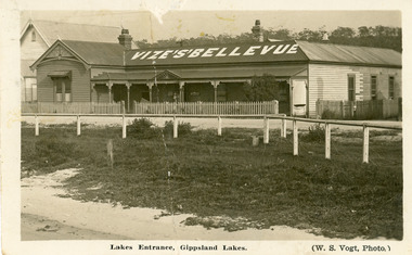 Lakes Entrance Historical Society
Postcard - Vizes Bellevue Guesthouse, 1920c
Also photographic enlargement 20 x 25, also enlargement copy 28 x 35 in frameless frame. Also re Donor, Mrs Lucy King, previously Sanberg, nee Olsen, was the proprietor of Bellevue Guesthouse 1946 to 1988Black and white postcard of Vizes Bellevue Guesthouse, showing a large weatherboard building, corrugated iron hipped roof, gable at left front. Veranda across the front, picket fence enclosing front yard. Wire strung wooden fence between roadway and grassy area bordering sandy beach at lake edge. Kerosine tin on grass, church visible beside guest house. Lakes Entrance Victoriaguesthouses, waterfront, architecture -
 Bendigo Historical Society Inc.
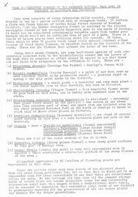
Document - PETER ELLIS COLLECTION: REMARKS ON PROPOSED NATIONAL PARK AREA
... of the Bendigo Area. It lists grasses and reeds with their common names... POACEAE of the Bendigo Area. It lists grasses and reeds ...Some Introductory Remarks on the Proposed national Park Area in Parishes of Mandurang and Sandhurst printed on white A4 paper. Same as 8626.446 b with two front pages and the bottoms of some pages missing. An extra page at the end is titled POACEAE of the Bendigo Area. It lists grasses and reeds with their common names and scientific names.bendigo, parks and gardens, national parks, peter ellis collection, wild flowers