Showing 302 items
matching ground covers
-
 Federation University Historical Collection
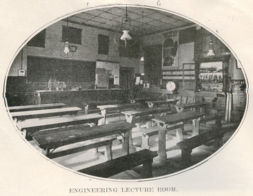
Book, Ballarat School of Mines, Ballarat School of Mines Calendar, 1911, 1911
In 1911 R. Maddern was President of the Ballarat School of Mines. Contents of this booklet are: Asssociateship, Calendar, Certificate Courses, Departmental Regulations, Discipline, Discipline Board, Examination Results, Fees, Full Certificates Issued, General Regulations, Introduction, Junior Technical School, Officer Bearers, Professors and Lecturers, Subjects of Instruction - Department of Chemistry and Metallurgy, Geological Department, Engineering Department, Electrical Engineering Department, Department of Mathematics and Physics, Practical, Plane and Solid Geometry, Photography, Subscriptions and Donations 1910. Plan of Buildings and Grounds Engineers with qualifications from the Ballarat School of Mines were sought by mines throughout the world. Blue soft covered book of 64 pages titled the Ballarat School of Mines Calendar. The book includes images of the Engineering Room, the Maddern Roasting Furnace, Museum, Junior Chemical Laboratory, Plan of Buildings and Ground, Chemical Laboratory, Concentration Floor, Linkenbach Table, Engineering Laboratory, Experimental Steam Engine, Chemical Lecture Room, Physics Instruction Room, Newtonian Telescopy, Ballarat Observatory, Instructor's Laoratory, Wilfrey Table, Chlorination plant, Cyanide House and R. Maddern. ballarat school of mines, scientific equipment, engineering, classroom, desks, gas lighting, calendar, r. maddern, j. m. bickett, w. h. middleton, j. d. woolcott, w. nixon, daniel. walker, fred j. martell, professor a. mica smith, hubert r. murphy, charles a. deane, arthur garrard, professor t. s. hart, professor a. d. gilchrist, a. e. c. kerr, j. brittain, e. j. a. mcconnon, john m. sutherland, bertram whitington, h. j. hall, e. gutheil, charles campbell, t. williams, d. e. mullins, sir redmond barry, judge rogers, r. m. sergeant, thomas bath, andrew anderson, general regulations, discipline, discipline board, associateship and final certificates, mining engineering, metallurgy, geology, electrical engineering, certificate courses, junior technical school, fees, subjects of instruction, chemistry, geological department, engineering department, electrical engineering department, department of mathematics and physics, practical, plane and solid geometry, photography, full certificates issued, supplementary examination results - may 1910, supplementary examination results - april 1908, subscriptions and donations 1910 -
 Federation University Historical Collection
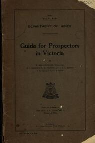
Book, Guide for Prospectors in Victoria, 1931, 1931
The handbook was intended for those with little experience who wanted to prospect of fossick.Grey soft covered book of 90 pages. Includes fold out map of a portion of Victoria showing auriferous areas and mineral localities. Also show Counties of Victoria and localities of minerals such as tin, antimony, copper, silver lead, Malybdenite, tungsten ores, manganese, platinum, osmiridium and iron. Chapter heading s include: working alluvial deposits, equipment, geology of Victoria, gold deposits, quartz reefs, indicators, economic minerals, assistance to prospectors, Miners' Right, mining bye-law, mining leases, forest regulations and glossary. Descriptions are given of a god dish, puddling tub, cradle, puddling machine, ground sluicing, boring, windlass, whim, hand dollying, sweeping, California pump, and wing dam.mining, baragwanath, gold, prospector, geology, quartz reefs, alluvial deposits, indicators, victorian goldfields, miners rights, mining leases, forest regulations, sluicing, sluice box, puddling machine, miner's cradle, whim, whip, california pump, gold nuggets, saddle reef, ballarat indicators, state batteries -
 Federation University Historical Collection
Booklet, D. Wixted, Garden at School of Mines and Industries Ballarat: Conservation Analysis, 1988, 07/1988
The Ballarat School of Mines Botanical Garden was established in 1879, and was used by students of botany and materia medica. In February 1881 George Porter Day was appointed gardener at a rate of 17 pounds and ten shillings per annum. Yellow covered stapled report of 20 pages. Includes information about the establishment of the Ballarat School of Mines, plans of ground and buildings (1880, 1881, 1903 and 1988), Botany subjects, history of the garden, the garden in 1988.Some words have been highlighted in orange.ballarat school of mines botanical gardens, ballarat school of mines, george day, george porter day, james oddie, baron von mueller, von mueller, ferdinand von mueller, joseph flude, materia medica, botany, system garden, ferdinand krause, field club and science society, pharmacy, alfred mica smith -
 Flagstaff Hill Maritime Museum and Village
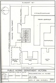
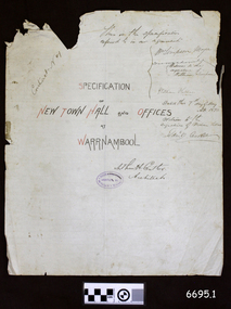
Legal record - Plans and Contract, Arthur H. Cutler, Architect, Warrnambool Town Hall, 1890-1892
This is a set of documents including three sheets of blueprint plans for the New Town Hall and Offices for Warrnambool, created in 1890 by the Architect Mr Arthur H. Cutler of Melbourne. The Contract was signed by the Town Mayor for Warrnambool, Mr William Simpson on May 7th 1890. Also, a Council copy of the Contract dated 26 June 1890, with the signatures and diagram where the two official stamps would be placed. The Foundation Stone was laid the following year by the next Mayor, John Hyland on February 24th 1891. The contractor for the building was granted to W. Kellas (William) of Warrnambool. The Town Hall and Offices were built on the corner of Liebig and Timor Streets in Warrnambool. On March 20th 1983 the new Performing Arts Centre was opened y the Mayor, Councillor R w Andreson, on the same site. The new building incorporates the 1890 Town Hall building. The plans, contracts, documents and various references to people on the documents are significant to the history of the City of Warrnambool and its community. The Warrnambool Town Hall building is also significant for the many community events held there over the decades after it was built. Appreciation for the significance of the almost century-old Town Hall building is demonstrated by its inclusion in the new Performing Arts Centre.Set of five documents that includes Plans for the Warrnambool Town Hall, the Contract cover page and a letter from the Architect to the Council. The Contract cover page and the Letter are hand written on cream-coloured paper with a waxy finish, with watermarks. 1) Contract Cover Page, 5th May 1890, Specification of the New Town Hall and Offices at Warrnambool. 2) Letter, 29th January 1892, from Architect Arthur H. Cutler to Mayor and Councilors, Town of Warrnambool 3) Blueprint Sheet 4, Longitudinal Section, and profiles of Liebig Street and Timor Street, Warrnambool Town Hall, 4) Blueprint Sheet 3, First Floor & Balcony Plan, and Roof Plan 5) Blueprint Sheet 2, Ground Floor Plan, Warrnambool Town Hall 6) Contract, 26 June 1890, marked (Draft Copy Tow Hall Contract), Between Mayor, Councillors and Rate Payers, and William Kellas, ContractorWatermarks on handwritten pages [horizontal lines], "36" "BUSBRIDGE'S / LOFT DRIED" Contract cover page, Oval stamp "CUTLER - 281 COLLINS ST. E. MELBOURNE - ARCHITECT " (other crossed out text) Handwritten script "This is the specifications referred to in our agreement" "Dated this 7th day of May A.D. 1890" Signed "W. Simpson Mayor" "Arthur H. Cutler Architect", [two Witnesses' signatures and others] Letter from Arthur Cutler, handwritten, has his address "472 Chancery Lane, Melbourne" CONTRACT of 26 June 1890: "The Mayor, Councillors and Rate Payers of Warrnambool" "William Kellas of Warrnambool" "Signed William Simpson, Maoyorr" "R F Kennedy, Councillor" "Wm Kellas" with diagrams where the round Common Seal and square Stamp would be applied.warrnambool, flagstaff hill, warrnambool, flagstaff hill maritime museum, maritime village, shipwreck coast, great ocean roaad, warrnamboo town hall, warrnambool council offices, mayor william simpson, arthur h cutler, architect, civic centre, town hall, performing arts centre, mayor john hyland, william kellas, mayor r w anderson, r f kennedy, contract -
 Federation University Historical Collection
Book, Victoria Australia: Innovation Events Energy
Blue hard covered book with dust jacket.holden, university of ballarat, smorgon steel, dennis family, melbourne water, tattersall's, east gippsland institute of tafe, gippsland water, multicultural victoria, murray goulburn co-operative, bendigo mining nl, mccain foods, melbourne docklands, mccain foods, melbourne cricket ground, olympic park, state library of victoria, great ocean road, lavendula, grampians, gippsland, bhp billiton -
 Federation University Historical Collection
Document, History of the Ballarat Technology Park, Oakbank
The Ballarat Technology Park is associated with Federation University Australia. The first stage commenced on 03 August 1989 when the first sod was turned by Hon, David White, Minister for Industry, Technology and Resources. John Beaumont was the Director of the Ballarat Technology Research and Development Park in 1989.Twenty items relating to the History of the Ballarat Technology Park as collected by John Parkin. .1) Handwritten notes by John Parkin on the history of the Ballarat Technology Park .2) Letter from A.E. Helyar (Shire of Buninyong Secretary), 08 March 1988 .3) Shire of Buninyong Minutes 07 June 1988 .4) Development of High Technology Activity by Jack Barker .5) Definition of a Technology Park by Derek Woolley .6) Shire of Buninyong minutes 28 June 1988 .7) Shire of Buninyong minutes 19 July 1988 .8) Invitation to a reception to commemorate the inauguration of the Ballarat Technology Park (John Parkin) by Shire of Buninyong President Cr Judith Coull to be held on 03 August 1989. .9) Invitation to a reception to the Ballarat Technology Park (John Beaumont) .10) Ballarat Courier article 04 August 1989 .11) Draft letter to Professor Geoffrey Blainey from John Parkin .12) Letter to the Editor from John Parkin, 18 December 2000 .13) University of Ballarat Development Appeal, 04 November 1994 .14 & .15) Invitation to installment dinner to celebrate the installation of Professor Geoffrey Blainey as Chancellor of the University of Ballarat to be held in the Union Building (now Albert Coates Building), Mt Helen campus .16) Letter to the editor from John Parkin .17) Letter from John Beaumont, 25 November 1994 .18) Invitation to the opening of the ISSC Southern Region Data Centre to be held on 24 November 1995. .19) Letter from Barry Traynor, 13 December 1995 .20) Planning Scheme information relating to the LaTrobe Research and Development Zone. .1) 2nd May 2005 History of Technology Park (I.T. centre) The history of the Technology Park started back in the mid-1980s. At the time I was a Buninyong Shire Councilor and as such I was Buninyong's representative on the then Ballarat Development Committee. At one of our meetings we received a request for information on a suitable site for a technology park. The requirements were for a site adjacent to a tertiary institution, secluded for security purposes and large enough to contain such a development. The next morning I contacted our Shire Engineer at the time, Newell Barrett and we drove around the area we both agreed that the current site was the most suitable we saw to meet the requirements. At the time it was owned by George Morrison. however the original enquiry to the B.D.C. came to nothing but the Shire Council and the B.D.C. decided to investigate the possibility of the site becoming a technology Park and information was collected. At about this time Mr Morrison put the property on the market and it was bought by a Ballarat builder, Mr John Beaumont, with the idea of developing it as a residential area. Council then arranged a meeting with Messrs Morrison and Beaumont to discuss the matter. I remember Mr Morrison saying he did not care what was done with it he just wanted to sell it and move down to the coast. Mr Beaumont, on the other hand, said he wasn't ready to retire yet and the idea interested him. As a result a committee consisting of the B.C.A.E., B.D.C. and Buninyong Shire Council (and Mr Beaumont) was formed to plan the development and rezone the area to technology park. It was previously zoned residential land and would seem to have been suitable for sub-division and residential development - its close proximity to the College being a major factor in its favour. The point of this is if Mr Beaumont had insisted on pursuing his original plan and had opposed the rezoning, I am quite confident he would have won an appeal at the A.A.T . (Administrative Appeals Tribunal - forerunner of V.C.A.T.) and the I.T. centre would not have got off the ground and the area would be covered with houses. But Mr Beaumont did go into the project with enthusiasm and the first stage was commenced on the 3rd August 1989 when the first sod was turned by Hon. David White, the Minister for Industry, Technology and resources (See the Courier 4th August 1989) Mr Beaumont went overseas to study similar parks and look for tenants. Unfortunately government did not support the project as they have now and apparently Mr Beaumont was ahead of his time for the private sector so Mr Beaumont could not continue the development and the site eventually passed to the College. I personally think more could have been done ... The work done by the Buninyong Shire Council and Ballarat Development Committee seems to have been forgotten as according to the Courier December 21, 2000 we are told the Park opened in 1995 as a joint venture between the City and the University. As a former Councillor said to me on the day "What happened to the plaque David White unveiled in 1989!" If there is any other information you want, please contact me. You may use my file for reference. Kind regards John Parkin PS I always felt a bit guilty that I encouraged John Beaumont and he was left in the lurch. ballarat technology park, parkin, john parkin, helyar, barker, woolley, shire of buninyong, beaumont, blainey, geoffrey blainey, southern region data centre, greenhill enterprise centre, stan jeffrey, jeffrey, john beaumont, david white -
Federation University Historical Collection
Document - Booklet, 'Breaking New Ground: Outlining the Origins of the University of Ballarat' by Jack Barker, 2014
E.J. Barker was the Principal of the Ballarat School of Mines, and the first Director of the Ballarat Institute of Advanced Education. In one booklet, a letter from 6th February 2014 states that this copy has been forwarded to Ex-Staff Association Members from Verna Barry, secretary of BESA.Booklet outlining the memories of E.J. Barker, the first Director of the Federation University Mt Helen Campus (then Ballarat College of Advanced Education). Two booklets, each 28 pages. Bound with plastic comb binding, has thicker card for back cover. One booklet has a typed paper letter taped in the back.e.j. barker, jack barker, mount helen, mount helen campus, ballarat school of mines, ballarat institute of advanced education, melbourne college of advanced education, alf reed, martin committee, mount clear, ray bell, lord casey, sir zelman cowen, 1870s founders hall, peter karmel, state college victoria ballarat, john dawkins, turning the sod, history, verna barry, ex-staff association, breaking new ground, university of ballarat -
 Flagstaff Hill Maritime Museum and Village
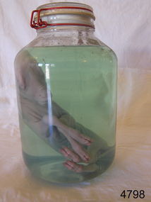
Animal specimen - Lamb Fetus
This lamb fetus has been placed in preserving fluid. This can be formaldehyde, isopropyl or ethanol. It is important that glass jars are used, as plastic will be affected by the chemicals over time in the preserving fluid. Note the glass lid and the rubber seal; also the plastic covered metal clasp that has no contact with the contents. It is not known how long the lamb has been in this jar, but it is remarkably well preserved with just a little film of scum on parts on the top of the interior of the jar.The use of such preserved specimens is widespread in teaching students of all ages, veterinary operatives and museums of the composition of certain animals, insects and birds. Any information about an animal — be it photographs, blood, feathers or fur samples — is better than no information at all. But specimens are vital to ground-truth.Large glass jar containing a lamb fetus in preserving fluid. Glass lid is secured with rubber seal and metal fastening. flagstaff hill, flagstaff hill maritime museum and village, warrnambool, maritime museum, maritime village, great ocean road, shipwreck coast, lamb, fetus, lamb fetus, animal specimen, biological specimen -
 Yarra Glen & District Historical Society
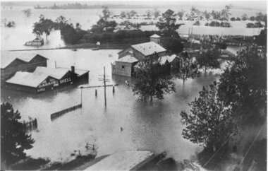
Black and white photographs, Flood waters in Yarra Glen December 1934
Black and white photograph of Bell street, Yarra Glen, taken in December 1934 from the tower of the Grand Hotel, looking south towards the railway crossing, during the floods. The Victoria Hall is the building in the centre of the photograph. Directly behind the Victoria Hall, the roof of 'River View' guest house can be seen. The Shell Garage, operated by Les Orenshaw, on the left of the photograph was originally built and occupied as a peg factory.The view extends from Bell street across the river flats with the high ground of Chateau Yering in the background. Bell Street is defined by the street trees where the water covers the road in the foreground grand hotel, victoria hall, bell street, floods 1934, 1934 flood, railway crossing, river view, guest house, shell garage, peg factory, river flats, chateau yering, les orenshaw, street trees -
 Federation University Historical Collection
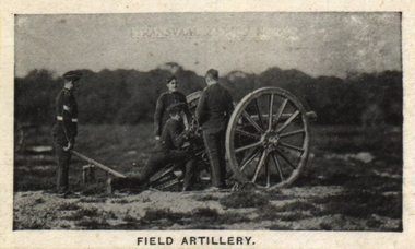
Photograph (black & White), Field Artillery - South Africa
The Second Boer War saw attempted application of bombardment as an alternative to the use of ground forces. In most battles fought during the conflict this was proved not to be possible. There was competition from the other side's ability to take evasive measures. The opponent was able to use cover to protect himself and hide his position. This was the tactic used against the British at the Battle of Magersfontein and the Battle of Colenso. The British had success when they ceased using artillery by itself and used it in conjunction with infantry. British General Buller linked the use of artillery and the movement of infantry in continuous interlocking assaults upon each hill south of Ladysmith. As soon as shelling had finished in a location the infantry moved. The front collapsed on the 27 February 1900 when use was made of a creeping curtain of shell fire sent over the heads of advancing infantry destroying everything 100 yards ahead of them. It was this tactic of the creeping barrage that has been described as "revolutionary'. Individual image from photographed poster of tobacco and cigarette cards.second boer war, ground forces, battle of magersfontein, battle of colenso, general buller, infantry, ladysmith, interlocking assaults -
 Federation University Historical Collection
Booklets, Coventry Engineering Society Journal, 1926, 1926
Six grey soft covered Coventry Engineering Society Journals. .1) Vol. 6 No. 3, March 1925. Includes * The Influences of Rates of Colling upon Cast Iron by H. Beeny * Pulverised Coal by J. Pickin (Junior) .2) Vol. 7. No. 1, January 1926. Includes * Coventry Engineering Society Annual Report * Road Springs by C.E. Cary .3) Vol. 7. No. 2, February 1926. Includes * Some methods of Testing Engines by G.H. Walker Vol. 7. No. 3, March 1926. Includes * Notes on the Disposal of a Town's Refuse by H.L. Bunting * How roadcasting is Done by J.A. Cooper Vol. 7. No. 4, April, 1926. Includes * The Applicaton of Thermionic Repeaters to Long Distance Telephony by H.C. Hannam-Clark Vol. 7. No. 5, May 1926. Includes * Automobile Design by W. Ferrier Brown * Floodlighting and its Possibilities by H.C. Wheat Vol. 7. No. 6, June 1926. Includes * Machines for Testing Materials by H.N. Cox * Characteristics and uses of Ground Gears by H.F.L. Orcutt * Instruments for Recording Minute Oscillations * Characteristics of Iron Ores by A.J. Aierscoventry, engineering, coventry engineering society, peterborough cathedral, cast iron, h. beeny, pulverised coal, j. pickin (junior), road springs, c.e. cary, testing engines, g.h. walker, disposal of a town's refuse, h.l. bunting, roadcasting, j.a. cooper, thermionic repeaters, long distance telephony, h.c. hannam-clark, automobile design, w. ferrier brown, floodlighting, h.c. wheat, machines for testing materials, h.n. cox, ground gears, h.f.l. orcutt, instruments for recording minute oscillations, iron ores, a.j. aiers -
 City of Moorabbin Historical Society (Operating the Box Cottage Museum)
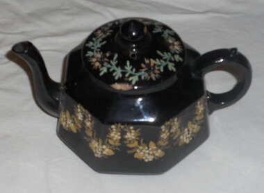
Domestic object - Kitchen Equipment, Tea Pot, Between 1885 and 1905 after which the backstamp changed to G & S LTD
Earthenware is lightly fired, readily absorbs water if not glazed, and does not allow light to pass through it. Coarse earthenware is made from clay and grog (ground up fired pot). There are two main types of glazed earthenware: One is covered with a transparent lead glaze; when the earthenware body to which this glaze is applied has a cream colour, the product is called creamware. The second type, covered with an opaque white .in glaze, is variously called tin-enamelled, or tin-glazed, earthenware, majolica, faience, or delft. G&S marking could be Grove & Stark, Longton, England (1871-1884). In the 19th century, J. & G. Meakin ,1851 based in Hanley, Stoke-on-Trent, Staffordshire, was known for the vast quantities of cheap ironstone china it produced for the domestic English market and for export to Australia, Canada, New Zealand and the United States. Grove & Stark were taken over by Meakin early 20thC The Mark could also be Gibson & Sons (Ltd), were notably manufacturers of earthenware Burslem, Stoke-on-Trent. Founded around 1885 and traded until the mid 1970's. They were previously Gibson, Sudlow & Co. Manufactured between 1885 to 1905. Small earthen-ware, black-glazed tea-pot. 8 sided. The body of the tea-pot is decorated with hand-painted gold flowers and raised cream flowers. The lid is also hand -painted with green leaves and flowers. This floral pattern is named "Garland" The lid is not of the same pattern as the base. The spout was broken when brush tailed possum entered Cottage via chimney 27/4/2014. Can be repairedOn the base of the tea-pot. Makers Mark is G & S. "Garland". (Pattern), Rg. No. 175153. Also 'Made in England'. Under glaze there is the word: England.crockery, earthenwarre, gibson & son ltd, grove & stark ltd, pioneers, early settlers, bentleigh, market gardeners, moorabbin, cheltenham, pottery, stoke- on - trent, england, longton, burslem, wedgwood -
 Bendigo Historical Society Inc.
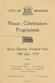
Document - LYDIA CHANCELLOR COLLECTION; PEACE CELEBRATION PROGRAMME
Brown leaflet with black print. On the front cover are the words ' City of Bendigo Peace Celebration Programme. Sports Ground, Rosalind Park, 19th July, 1919. Speakers: His Worship the Mayor (Cr. A. Dunstan) Sir John Quick Lieut. Col. Adams, V.D., Chap. Col. Crookston. W. Honeybone, Town Clerk A. Dunstan' Inside the leaflet is the actual programme and on the back cover are the Procession Instructions. Cambridge Press.event, official, war, lydia chancellor, collection, w.w.ii, programme, event , celebration, program, peace, war -
 Bendigo Historical Society Inc.
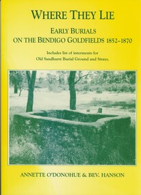
Book - WHERE THEY LIE
'Where They Lie'. Early burials on the Bendigo Goldfields 1852 - 1870. Including list of interments for Old Sandhurst Burial Ground and Strays. Limited Edition No. 157. Receipt for purchase loose inside front cover.Annette O'Donohue and Bev. Hanson.cemetery, old sandhurst burial ground. -
Bendigo Historical Society Inc.
Booklet - Rushworth Gold Mines
The Rushworth gold rush began in 1853 and ended in 1870 when rising ground water made it unprofitable. The area then turned to the timber industries until the 1940's. It is estimated that the Rushworth goldfields produced approximately 100,000 ounces of gold.51-page soft cover booklet. Pale yellow covers. 'The Rushworth Gold Mines' A descriptive narrative of the Rushworth Gold Mines as prepared by the staff of the 'Rushworth Chronicle' and published in that journal in 1918. Mines are listed by name. rushworth, gold mines -
 Bendigo Historical Society Inc.
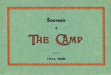
Document - SWEENEY COLLECTION: SOUVENIR BOOKLET YMCA SERIES THE CAMP, WW1 Era
Six page booklet, green cover with red highlights, 'Souvenir of The Camp.' (YMCA Series) Contains photos which show different aspects of a large camp: Post and telegraph office, Entertainment at 'The Palace', General office, officers' mess, camp hospital, tennis ground, and the Salisbury cathedral. 3480.17a Front Cover 3480.17b Last Photo inside back cover Inside the back cover - 'Wishing Pa, Merry Christmas and Happy New Year 1918-19.' (The signature is indistinct)military, world war 1 -
Port Melbourne Historical & Preservation Society
Programme - Port Melbourne vs West Adelaide, Foxtel Cup R1, MCG, Trevor Ruddell, MCC library, The MCC Library Record, Jun 2013
This Football record was produced by the Melbourne Cricket Club Library as an extension of their usual match day fact sheet when they discovered there was not going to be an official program for the above match at the MCG. Provided free of charge to people attending."The MCC Library Record" Vol 1 No 1 June 11 2013. Foxtel Cup Round 1 MCG. Port Melbourne vs West Adelaide. All the above is on the front cover plus a purple/brown printed drawing of a football match being played in front oif a large crowd; tent and trees in background. Eight page booklet.sport - australian rules football, melbourne cricket ground, port melbourne football club, pmfc -
 Port Melbourne Historical & Preservation Society
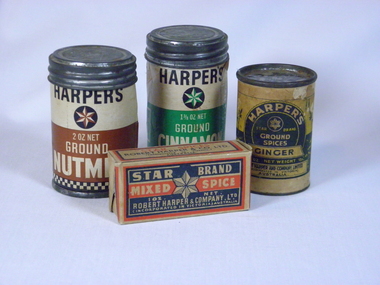
Domestic object - Pack, Harper's spice, ground cinnamon, Robert Harper and Company Ltd, 1960s
This has been in Ken Turner's pantry for a long, long timeHarper's spice pack (Robert Harper and Co. Ltd.): 1 1/8 oz ground cinnamon c 1960s? Green and black on white cardboard container, tin coverindustry - manufacturing, robert harper & co ltd, spice -
 Port Melbourne Historical & Preservation Society
Domestic object - Pack, Harper's spice, ground nutmeg, Robert Harper and Company Ltd, 1960s
This has been in Ken Turner's pantry for a long, long timeHarper's spice pack (Robert Harper and Co. Ltd.): 2 oz ground nutmeg 1960s? Brown and black on white cardboard container, tin coverindustry - manufacturing, robert harper & co ltd, spice -
Port Melbourne Historical & Preservation Society
Book, Terry Keenan, A Family Feud: Fifty years of conflict in the management of the Port Melbourne Cricket and Recreation Reserve, 2001
Written 2001, published twice, may be reprinted several times. Current version has cover reversed and only 52 pages; 24 July 2018'A Family Feud: Fifty years of conflict in the management of the Port Melbourne Cricket and Recreation Reserve' - Paper detailing the early history of the management of the Port Melbourne Cricket Ground, 65pp. by Terry KEENAN 2001sport - cricket, sport - recreational grounds, sport - australian rules football, local government, terry keenan -
Port Melbourne Historical & Preservation Society
Book, Minute Book - Committee of Management of Cricket Ground, 1907 - 1956
Book containing handwritten minutes of the Committee of Management for the Cricket Ground/recreation reserves Sept 1907 (1945) to February 1956. Red covers and binding deteriorated. Minutes after 1947 have been typed, and stapled into the book.sport - recreational grounds, sport - australian rules football, sport - cricket, sport - soccer, sport - baseball -
Port Melbourne Historical & Preservation Society
Document, Port Melbourne Football Club Ltd.130th Annual General Report 2005, 2005
From the collection of Terry KEENAN.Port Melbourne Football Club Ltd.130th Annual General Report Season 2005, A4 28 pp plus cover with sepia photograph of Port Melbourne Football Ground 1874. Includes copy of Statement of Financial Performance 2005.sport - australian rules football, port melbourne football club, pmfc -
 Monbulk RSL Sub Branch
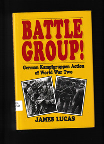
Book, Frontline Books, Battle Group : German Kamfgruppen Action in World War Two, 2014
The German army in the Second World War sought to fight and win swift, decisive victories in a succession of short campaigns - blitzkrieg, or lightning war. Flexibility was as essential as the will to win. Battle groups, or shock troops, were created from miscellaneous, and often disparate military units to undertake a specific local operation; it was the army's skill in combining superior numbers, aggressive tactics and the battle group commander's ability to exploit the changing situation on the ground which brought success on the battlefield. The actions described here cover all theatres of the war, and include battle groups large and small, deployed usually to smash a breach in the enemy line or seal off an enemy penetration. It covers operations in the first dynamic years when Wehrmacht forces defeated the armies of one European country after another in fast campaigns, through to the years after Stalingrad and Africa as they moved towards defeat. The battle groups' contribution to Wehrmacht fortunes offer powerful lessons in the tactics of battle management and this book by James Lucas, a military historian known for his close studies of the German soldier, is considered to be one of the most detailed and authoritative accounts on the subject. Collapse summaryIndex, bibliography, maps, ill, p.173.non-fictionThe German army in the Second World War sought to fight and win swift, decisive victories in a succession of short campaigns - blitzkrieg, or lightning war. Flexibility was as essential as the will to win. Battle groups, or shock troops, were created from miscellaneous, and often disparate military units to undertake a specific local operation; it was the army's skill in combining superior numbers, aggressive tactics and the battle group commander's ability to exploit the changing situation on the ground which brought success on the battlefield. The actions described here cover all theatres of the war, and include battle groups large and small, deployed usually to smash a breach in the enemy line or seal off an enemy penetration. It covers operations in the first dynamic years when Wehrmacht forces defeated the armies of one European country after another in fast campaigns, through to the years after Stalingrad and Africa as they moved towards defeat. The battle groups' contribution to Wehrmacht fortunes offer powerful lessons in the tactics of battle management and this book by James Lucas, a military historian known for his close studies of the German soldier, is considered to be one of the most detailed and authoritative accounts on the subject. Collapse summary germany - armed forces - history, germany - regimental histories -
 Bendigo Historical Society Inc.
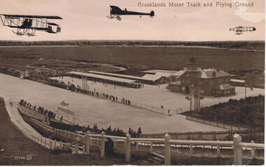
Postcard - BASIL WATSON COLLECTION: BROOKLANDS MOTOR TRACK AND FLYING GROUND
The postcard shows three planes flying above the Brooklands motor track with 'Brooklands Motor Track and Flying Ground'. To the right is a large two story brick building and on the left of the building is a long open covered vehicle stall. To the back are work sheds, further to the left are spectators cars and in the distance is open space with trees. Spectators line the race track both sides watching a racing car. In the foreground is a hill with fencing down to the track and spectators along the fence.Valentine Seriesaviation, civilian, brooklands motor track -
 Bendigo Historical Society Inc.
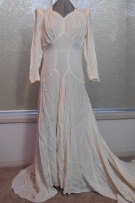
Clothing - CREAM WEDDING DRESS WITH EXTENDED TRAIN, 1930's
Long lily-pointed sleeves, fastened at the wrist with six X 0ne cm covered buttons and loops. A firm padded roll 19cm long, and eleven cm circumference sits at the shoulder at top of sleeve. A gathered panel on either side of the neckline forms a sweetheart neckline. Gathering under the bust, and a A shaped centre front panel - with V shape at lower edge-panel 33cm long. Two semi-circular panels 28 X 19cm from side seam to the centre front, and defining the shape of the peaked centre panel. A small inverted pleat comes from th ebottom peak of the centre panel. Skirt is circular and extends into a sweeping train.29 covered buttons with loops extend from the back neckline to the curved join at the hipline of bodice and skirt. A one cm band of fabric has been machine stitched around the hemline, and hand rolled and hand stitched to give weight and finish at the hemline. Two X 2.5cm loops, hand stitched are at the left and right sides, to slip over the fingers to hold the train above the ground.costume, female, cream wedding dress with extended train -
 Bendigo Historical Society Inc.
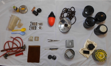
Mixed media - DONEY COLLECTION: DARKROOM EQUIPMENT
Alan Doney darkroom collection: 40a dartk room equipment collection 40b four film devreloping cannisters, adapts to adjustable film sizes (35mm, 120mm etc) 40c spool winder in two parts, stored in scotch tape tin 40d developer lens holder and fil/negative constraint for enlarging photos 40e darkroom light shade with electricity chord 40f red darkroom safety light for developing film with the darkroom 40g three developing items - two lens caps, thremometer caps/containers, & photo developing tongs 40h leather pouch for protection of flat ground glass panes 40i steel slide cover & bracket 40j two sets of steel film weights to hold/hang developed photograph films 40k rubber tubes and syphons 40l two plastic measuring beakers & two (yellow & blue) plastic spoons for developing process 40m KODAK film flow solution (Keogh's Camera Store $1.02) & KODAK plus-X pan film tin container 40n three darkroom miscellaneous items (includes Uniprint eqipment knob) -
Bendigo Historical Society Inc.
Newspaper - OLD VIOLET SHAFT - VIOLET ST. MINE 'BOILS' AGAIN
Newspaper article titled 'Violet St. Mine 'Boils' Again. A child walking near the shaft saw the ground collapse and shortly afterwards smoke drifting up. He told his parents who called the Bendigo Police. The area around the mouth of the saft was covered in cracks and seemed likely to collapse. Earlier a nearby resident had placed old iron and metal sheets over the area so that children would not walk on it. Once again children were attracted to it. Article from the Bendigo Advertiser dated 19/6/67.newspaper, bendigo advertiser, old violet shaft, old violet shaft, violet st. mine 'boils' again, mines department, bendigo police -
 Bendigo Historical Society Inc.
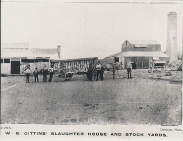
Photograph - HARRY BIGGS COLLECTION: W.B GITTENS SLAUGHTER HOUSE, C. 1900
Photograph showing a horse and long open sided cart with a covered roof, There are numerous carcasses (sheep?) hanging from the roof. There are seven men standing beside the cart. To the left of the cart there is a wooden building with a small brick chimney on the right hand end. To the right is a larger wooden structure with a large square brick chimney behind. There are also two other carts visible with their shafts resting on the ground. At the base of the photo is written Plate 147, W. B. Gittens Slaughter House and Stockyards.Robinsonbuildings, commercial, slaughter hopuse, w, b, gittens slaughter house and stock yards, robinson -
Moorabbin Air Museum
Prowse Collection Box WP11 See details in Description section
-
Moorabbin Air Museum
Manual (item) - Aero Engines: Overhaul, Testing, and Installaion for Ground Engineers