Showing 682 items
matching grove street
-
 Old Colonists' Association of Ballarat Inc.
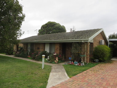
Photograph - Photograph - Colour, Clare Gervasoni, Symons Cottage, Charles Anderson Grove, Ballarat, 2017, 14/06/2017
... Village at Charles Anderson Grove, off Gillies Street,... Grove, off Gillies Street, charles anderson grove, ballarat ...The Old Colonists' Association of Ballarat Inc Retirement Village at Charles Anderson Grove, off Gillies Street,Brick Cottage at Charles Anderson Grovecharles anderson grove, ballarat, ballarat old colonists' club, old colonists' association, ballarat, symons cottage -
 Old Colonists' Association of Ballarat Inc.
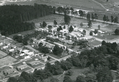
Photograph, Thornton Richards, Cottages at the Ballarat Old Colonists' Association Retirement Village, c1960
... Colonists' Association Retirement Village in Charles Anderson Grove... Anderson Grove, off Gillies Street. Lake Wendouree and the Ballarat ...The Old Colonists' Association of Ballarat Inc Retirement Village is located at Charles Anderson Grove.Thirteen black and white cottages at the Ballarat Old Colonists' Association Retirement Village in Charles Anderson Grove, off Gillies Street. Lake Wendouree and the Ballarat Gardens are in the background. old colonists' association ballarat, charles anderson grove, retirement village -
 Old Colonists' Association of Ballarat Inc.
Photograph, Thornton Richards, Cottages at the Ballarat Old Colonists' Association Retirement Village, c1960
... Colonists' Association Retirement Village in Charles Anderson Grove... (North) Street Ballarat Central goldfields The Old Colonists ...The Old Colonists' Association of Ballarat Inc Retirement Village is located at Charles Anderson Grove.Thirteen black and white cottages at the Ballarat Old Colonists' Association Retirement Village in Charles Anderson Grove, off Gillies Street. The retirement village is next to a caravan park, and Garden Court. old colonists' association ballarat, charles anderson grove, retirement village, garden court, caravan park, wendouree -
 Old Colonists' Association of Ballarat Inc.
Photograph, Thornton Richards, Cottages at the Ballarat Old Colonists' Association Retirement Village, c1960
... Colonists' Association Retirement Village in Charles Anderson Grove... Anderson Grove, off Gillies Street. The Caravan Park and Garden ...The Old Colonists' Association of Ballarat Inc Retirement Village is located at Charles Anderson Grove.Thirteen black and white cottages at the Ballarat Old Colonists' Association Retirement Village in Charles Anderson Grove, off Gillies Street. The Caravan Park and Garden Court is also evident in the photograph.old colonists' association ballarat, charles anderson grove, retirement village -
 Wodonga & District Historical Society Inc
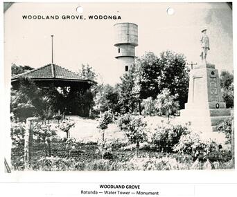
Photograph - Codling Collection 01 - Woodland Grove, Wodonga
... and the Wodonga Lapidary Club. Woodland Grove is located...A black and white photo of Woodland Grove in High Street... at the corner of High and Hovell Streets, Wodonga. ‘Woodland Grove ...Miss Olive Codling was a Foundation Member and a Life Member of the Wodonga Historical Society. Many of her prize-winning photos are held in the Society Collection. She also held a range of roles and committee positions in a wide range of Wodonga community organisations. These included the Horticultural Society, the Wodonga Arts Council, the Wodonga Camera Club and the Wodonga Lapidary Club. Woodland Grove is located in the triangular reserve at the corner of High and Hovell Streets, Wodonga. ‘Woodland Grove". It was named in honour of John Woodland at the same time as the opening of the band rotunda in September 1920. John Woodland, Wodonga Shire’s first president, was born in Kent, England, in 1829 and came to Sydney with his parents in 1839. He arrived in the Wodonga district about 1853, where he created a successful carrier's business. He first lived on the Old Barnawartha Estate and a few years later purchased land at Green Hills, Wodonga West, where he farmed and also ran a hotel. The hotel licence was relinquished to give attention to duties as secretary and clerk of works to Wodonga Shire, which was then the Wodonga Riding of the Shire of Yackandandah. He was a main agitator for the separation of Wodonga district from Yackandandah Shire. This was successful in 1876, and he became the first president of Wodonga Shire. He held this post for two years, then taking on the role of shire secretary in 1878 until 1913. He concurrently undertook the role of clerk of works (engineer) from 1896 to 1907. As clerk of works he prepared the plans and specifications for, and supervised the construction of the big bridges on the Albury road and at Bonegilla and other important works. In his mid 70s, he proffered his resignation on a number of occasions but it was not accepted. Despite physical weakness and impaired vision, John continued his duties to the end, with the help of his daughter Rose Murphy. Rose became shire secretary for 20 years after her father’s death in 1913.This photo collection is significant as it documents the naming of a public area in Wodonga to honour an original and long-serving member of the Wodonga Shire Council.A black and white photo of Woodland Grove in High Street, Wodonga. It includes the rotunda, the water tower and the soldier's memorial. There is a post and wire fence in the foreground as well as several trees and rose bushes. Beneath the photo: "WOODLAND GROVE / Rotunda - Water Tower - Memorial"high st wodonga, woodland grove, john woodland -
 Kew Historical Society Inc
Plan - Subdivision Plan, Mount Ida Estate, 1925
... residential allotments bordering Tooronga Road, Leura Grove, Constance... allotments bordering Tooronga Road, Leura Grove, Constance Street ...The Kew Historical Society collection includes almost 100 subdivision plans pertaining to suburbs of the City of Melbourne. Most of these are of Kew, Kew East or Studley Park, although a smaller number are plans of Camberwell, Deepdene, Balwyn and Hawthorn. It is believed that the majority of the plans were gifted to the Society by persons connected with the real estate firm - J. R. Mathers and McMillan, 136 Cotham Road, Kew. The Plans in the collection are rarely in pristine form, being working plans on which the agent would write notes and record lots sold and the prices of these. The subdivision plans are historically significant examples of the growth of urban Melbourne from the beginning of the 20th Century up until the 1980s. A number of the plans are double-sided and often include a photograph on the reverse. A number of the latter are by noted photographers such as J.E. Barnes.The Mount Ida Estate was a subdivision of fifty-two residential allotments bordering Tooronga Road, Leura Grove, Constance Street, and Mount Ida Avenue in Hawthorn East. The report of the sale of the Estate in The Argus (21 September) claimed that over 1,000 people attended the auction and that all allotments were sold on the day. On the other side of Constance Street, the plan identifies the ‘Eastern Recreation Reserve’ (now Anderson Park).subdivision plans - hawthorn -
 Whitehorse Historical Society Inc.
Document, Savage Estate, Nunawading, 1950?
... Court, Colbar Street, Lemon Grove and Springfield Road... on Savage Court, Colbar Street, Lemon Grove and Springfield Road ...A plan of the Savage Estate comprising of 46 lots on Savage Court, Colbar Street, Lemon Grove and Springfield Road.A plan of the Savage Estate comprising of 46 lots on Savage Court, Colbar Street, Lemon Grove and Springfield Road. For private sale. Agents: Drake & Co. and Armstrong & Hoath.A plan of the Savage Estate comprising of 46 lots on Savage Court, Colbar Street, Lemon Grove and Springfield Road.savage court, nunawading, drake & co., armstrong & hoath -
 Eltham District Historical Society Inc
Photograph, Belle Vue, Livingstone Road, Eltham, c.1960, 1960c
... and Grove Street. The western boundary was the Diamond Creek... and Grove Street. The western boundary was the Diamond Creek ...Photo taken at time of ownership by Eric Staff. Originally purchased by pioneer Eltham farmer Henry Stooke, Belle Vue farm comprised about 56 ha (140 acres) extending northerly from the northern boundary of Holloway’s 1851 Little Eltham subdivision. On the present day map the southern boundary was just north of Elsa Court and Grove Street. The western boundary was the Diamond Creek and extended northerly to Main Road where it turns easterly towards Research. It was traversed by the main road to Kangaroo Ground and beyond and from 1912 by the railway to Hurstbridge. From 1895 the farm was owned by William Williams and his wife Mary Ann. In 1914-1915 they built a new house now known as “Belle Vue”. They sold the land in 1920 and residential subdivision began soon after that. “Belle Vue” remains today on a large residential lot in Livingstone Road. The house and many old trees on the site have been subject to a heritage overlay under the Nillumbik Planning Scheme. Despite that overlay, most of the heritage trees were removed during sub-division and development of the property.Digital file only from scan of copy on loan to EDHSbelle vue, eltham, eric staff, houses, livingstone road, staff family -
 Eltham District Historical Society Inc
Photograph, Peter Pidgeon, Heritage Excursion: Woodridge Wander, 6 March 2021
... to Woodridge Linear Park in Grove Street just east of the Eltham East... to Woodridge Linear Park in Grove Street just east of the Eltham East ...The Woodridge Estate was a major residential subdivision that was developed in many stages in the 1970s and 80s. It extended easterly from the older residential area of Eltham into what had previously been largely privately owned bushland. The subdivision design took into account the steep topography and resulted in large blocks that enabled preservation of much of the tree cover. It included a number of small parks and walkways and the one kilometre long Woodridge Linear Park. A bushland area left as a proposed school site later became the Pauline Toner Butterfly Reserve for preservation of the rare Eltham Copper Butterfly. This walk explores some Woodridge streets as well as the linear park and butterfly reserve, a hilly walk of about 3 km and includes some moderately rough tracks. Permission to visit the external grounds of two private properties to view heritage listed houses not visible from the street was granted. The walk commenced at 2pm at the access to Woodridge Linear Park in Grove Street just east of the Eltham East Primary School (Melway ref 22 B4). This free walk was open to the general public as well as Society members. Whilst COVID restrictions did not require the wearing of masks in the open, masks had to be carried and all attendees registered with name and contct number.Born Digital (41 images)covid-19, eltham, eltham district historical society, heritage excursion, woodridge estate -
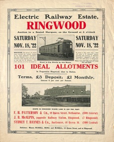 Ringwood and District Historical Society
Flyer, Land Sale Auction Brochure, Electric Railway Estate, Ringwood, Vic. - 1922
... Subdivision includes Bedford Road, Williams Grove, Campbell..., Williams Grove, Campbell Street, Myrtle Avenue, George Street ...Bi-folded single sheet with black and red print both sides advertising auction of allotments on Saturday, November 18, 1922, including details of subdivision features and local facilities. Subdivision includes Bedford Road, Williams Grove, Campbell Street, Myrtle Avenue, George Street, and Henry Street. Agents - F.H. Patterson & Co., 19 Queen Street, Melbourne, Tel. 4308 Central, J.B. McAlpin, Opposite Railway Station, Ringwood, Tel 7 Ringwood, SYDNEY T. Haynes & Co., Auctioneer, 60 Queen Street, Melbourne, Tel 3400 Central. -
 Eltham District Historical Society Inc
Photograph - Colour Print, Belle Vue, Livingstone Road, Eltham, c.2015
... and Grove Street. The western boundary was the Diamond Creek... and Grove Street. The western boundary was the Diamond Creek ...Belle Vue property in Livingstone Road, Eltham was once owned by Society member Jo McCormick. Jo was a valued member of our committee and dear friend of many of our members until her death in 2009. Belle Vue is the farmhouse of a property that is now a significant part of suburban Eltham, just a short distance north of the town centre. Originally purchased by pioneer Eltham farmer Henry Stooke, the present-day old farmhouse sits within an extensive suburban residential area. The history of the property is largely based on a heritage assessment prepared by consultant Lorraine Huddle for Nillumbik Shire Council. Additional information from our Society records reveals Belle Vue farm comprised about 56 ha (140 acres) extending northerly from the northern boundary of Holloway’s 1851 Little Eltham subdivision. On the present day map the southern boundary was just north of Elsa Court and Grove Street. The western boundary was the Diamond Creek and extended northerly to Main Road where it turns easterly towards Research. It was traversed by the main road to Kangaroo Ground and beyond and from 1912 by the railway to Hurstbridge. From 1895 the farm was owned by William Williams and his wife Mary Ann. In 1914 -15 they built a new house now known as Belle Vue. They sold the land in 1920 and residential subdivision began soon after that. Belle Vue remains today on a substantially subdivided and very much reduced size residential lot in Livingstone Road. The house and many old trees on the site were subject to a heritage overlay under the Nillumbik Planning Scheme. Despite that overlay, the development and subdivision of the original land resulted in most of the heritage listed trees being removed. belle vue, eltham, livingstone road -
Kew Historical Society Inc
Archive (Sub-series) - Subject File, CARRUCAN Pte. Thomas M. & Family, 1958
... , coal and coke) on the corner of Highbury Grove and High Street...) on the corner of Highbury Grove and High Street, Kew (Vic) for over 60 ...Various partiesReference, Research, InformationSecondary Values (KHS Imposed Order)Subject file including information relevant to the Carrucans of Kew. The Carrucans were fuel merchants, selling wood, coal and coke) on the corner of Highbury Grove and High Street, Kew (Vic) for over 60 years. The file contains two loosely bound archive files written by Francis William Lynch, one on Pte Thomas Michael Carrucan (1892-1951), and the other on the Carrucan family generally. The general history was presented to the Society in 2011 by Kathleen Murphy.carrucan family - kew (vic), pte thomas m carrucancarrucan family - kew (vic), pte thomas m carrucan -
 Ringwood and District Historical Society
Plan - Proposed Ringwood East Railway Station, VR Ringwood-Croydon (Dublin Road) - 1923
... . Surrounding streets include Dublin Road, Patterson Street.... Surrounding streets include Dublin Road, Patterson Street ...Technical drawing of "Proposed Station At 16Mls 38Chs 89Lks (Dublin Road)" inluding boundary line, red shaded platform with station buildings, and green shaded possible future "up" track. Surrounding streets include Dublin Road, Patterson Street, and subsequent hand-written additions of Railway Avenue, Lawrence Grove, Stanley Avenue, Wenwood Street, and Lois Street. Land title details of Patterson Street properties mainly illegible.Scale: 40'=1". Possible future (platform) extension for 8 car trains (and) extension for 10 car trains. -
Port Melbourne Historical & Preservation Society
Photograph - Presbyterian kindergarten children, c. 1949
... . GROVER at 141 Bridge Street (south-east corner of Nott Street... in the photo is the surgery/home of Dr. GROVER at 141 Bridge Street ...Photo of Garry COSHAM (second from right in the back row, the port side of the boat) and other Presbyterian kindergarten children c1949. Also visible in the photo is the surgery/home of Dr. GROVER at 141 Bridge Street (south-east corner of Nott Street), Creswick House at 139 Bridge Street, the grocer shop and residence at 180-2 Nott Street (north-east corner of Bridge Street) and residences at 184 and 186 Nott Street.education - kindergartens, religion - presbyterian church, garry cosham, harley grover, creswick house -
 City of Kingston
Photograph - Black and white, 20 December 1945
... with housing. Tulip Grove, Heather Grove and Gilford Street are visible... Grove, Heather Grove and Gilford Street are visible bottom left ...This aerial photograph depicts the changing landscape of Cheltenham and Highett since WWII. Photographed in 1945, there is a mix of urban dwellings and industrial development and precedes the major transformation of Cheltenham with the development of the Southland shopping centre in the 1960s and expansion in the 1990s.A large part of Cheltenham was originally established as a rural market gardening community. The railway line and station brought urban development to the area and in the north, the Highett area was dominated by the Highett Gas Works. Cheltenham became a major destination for shopping in the 1960s with the opening of Southland.Aerial photograph taken in 1945 of Cheltenham and Highett within the City of Kingston. The image includes the Highett Reserve, (top right), the Methodist Children Homes (now Southland), Nepean Highway and Jamieson Street. Highett Gas Works is visible in the top left and the land now named William Fry Reserve at the intersection of Bay Road and Nepean Highway. A visible large parcel of land on the corner of Bay Road and Nepean Highway was developed in the 1990s as the west side addition to Southland. The densely vegetated area in the upper right sector of the image is now dense with housing. Tulip Grove, Heather Grove and Gilford Street are visible bottom left. This image is possibly from the collection of aerial photographs commissioned by the Department of Crown Lands and Survey and taken by Adastra Airways.Black ink: 57252 White lettering: VIC-10 57252 20.12.45 [lens information indecipherable] PROJ. No.5 MELB. METROP AREA Black pencil: 80highett, cheltenham, highett gas works, urbanisation -
 City of Kingston
Photograph - Black and white, 20 December 1945
... with housing. Tulip Grove, Heather Grove and Gilford Street are visible... with housing. Tulip Grove, Heather Grove and Gilford Street are visible ...This aerial photograph depicts the changing landscape of Cheltenham and Highett since WWII. Photographed in 1945, there is a mix of urban dwellings and industrial development and precedes the major transformation of Cheltenham with the development of the Southland shopping centre in the 1960s and expansion in the 1990s.A large part of Cheltenham was originally established as a rural market gardening community. The railway line and station brought urban development to the area and in the north, the Highett area was dominated by the Highett Gas Works. Cheltenham became a major destination for shopping in the 1960s with the opening of Southland.Aerial photograph taken in 1945 of Cheltenham and Highett within the City of Kingston. The image includes the Highett Reserve, (top right), the Methodist Children Homes (now Southland), Nepean Highway and Jamieson Street. Highett Gas Works is visible in the top left and the land now named William Fry Reserve at the intersection of Bay Road and Nepean Highway. A visible large parcel of land on the corner of Bay Road and Nepean Highway was developed in the 1990s as the west side addition to Southland. The densely vegetated area in the upper right sector of the image is now dense with housing. Tulip Grove, Heather Grove and Gilford Street are visible bottom left. This image is possibly from the collection of aerial photographs commissioned by the Department of Crown Lands and Survey and taken by Adastra Airways.Black type: Reverse lettering VIC-10 57252 20.12.45 [lens information indecipherable] PROJ. No.5 MELB. METROP AREA White lettering: Reverse writing 57252cheltenham, highett, highett gas works, urbanisation -
 Eltham District Historical Society Inc
Photograph, 218 Pitt Street, Eltham, c.1985, 1985c
... and Wattle Grove, 218 Pitt Street, Eltham, c.1985 EDHS_04644-23.tif... and Wattle Grove, 218 Pitt Street, Eltham, c.1985 EDHS_04644-23.tif ...House was rented by Kim Tarpey between October 1983 and June 1985. It was one of the buildings originally part of Birds Orchard. Harold Bird was her landlord, a retired primary school teacher who, when she knew him was driving the mobile library bus. Her partner had him as a teacher at Montmorency Primary in grade 4. The house was next door to what is now a bushland reserve near the Pauline Toner Reserve. It was on the corner of Pitt and Arthur St - the driveway was near the roundabout and went off to the right of the driveway that now belongings to 220 Pitt street and which was bushland at the time. It was sold in 1985 and consequently demolished, a large house has replaced it. It was situated approximately where the front door of No. 218 is nowadays with the facade roughly in line with the now garage wall to the left of this front door.Digital file only - scanned from personal photo album on loan (27 images) List of images EDHS_04644-1.tif Kitchen window looking towards Eucalyptus Road, 218 Pitt Street, Eltham, c.1985 EDHS_04644-2.tif 218 Pitt Street, Eltham, c.1985 EDHS_04644-3.tif 218 Pitt Street, Eltham, c.1985 EDHS_04644-4.tif Kitchen looking towards Pitt Street Reserve, 218 Pitt Street, Eltham, c.1985 EDHS_04644-5.tif 218 Pitt Street, Eltham, c.1985 EDHS_04644-6.tif Bathroom walkway/laundry, 218 Pitt Street, Eltham, c.1985 EDHS_04644-7.tif 218 Pitt Street, Eltham, c.1985 EDHS_04644-8.tif 218 Pitt Street, Eltham, c.1985 EDHS_04644-9.tif 218 Pitt Street, Eltham, c.1985 EDHS_04644-10.tif 218 Pitt Street, Eltham, c.1985 EDHS_04644-11.tif 218 Pitt Street, Eltham, c.1985 EDHS_04644-12.tif 218 Pitt Street, Eltham, c.1985 EDHS_04644-13.tif 218 Pitt Street, Eltham, c.1985 EDHS_04644-14.tif 218 Pitt Street, Eltham, c.1985 EDHS_04644-15.tif 218 Pitt Street, Eltham, c.1985 EDHS_04644-16.tif 218 Pitt Street, Eltham, c.1985 EDHS_04644-17.tif Lounge window looking towards Mount Pleasant Road, 218 Pitt Street, Eltham, c.1985 EDHS_04644-18.tif Fire place in lounge, 218 Pitt Street, Eltham, c.1985 EDHS_04644-19.tif Fire place in lounge, 218 Pitt Street, Eltham, c.1985 EDHS_04644-20.tif View from lounge room window looking towards corner of Eucalyptus and Mount Pleasant roads, 218 Pitt Street, Eltham, c.1985 EDHS_04644-21.tif View from lounge room window looking towards corner of Eucalyptus and Mount Pleasant roads, 218 Pitt Street, Eltham, c.1985 EDHS_04644-22.tif View from lounge room looking towards Pitt Street and Wattle Grove, 218 Pitt Street, Eltham, c.1985 EDHS_04644-23.tif View from lounge room looking towards Pitt Street and Wattle Grove, 218 Pitt Street, Eltham, c.1985 EDHS_04644-24.tif 218 Pitt Street, Eltham, c.1985 EDHS_04644-25.tif Back garden showing previous tank stumps. There was a hole in the wall where a possum got through, 218 Pitt Street, Eltham, c.1985 EDHS_04644-26.tif View from back fence looking towards Pitt Street and Wattle Grove, 218 Pitt Street, Eltham, c.1985 EDHS_04644-27.tif View from back fence on to Eucalyptus Road. Pitt Street Reserve to the right, 18 Pitt Street, Eltham, c.1985218 pitt street, eltham, houses, birds orchard, harold bird, kim tarpey, eucalyptus road -
 Puffing Billy Railway
8 NB - Compartment Passenger Carriage, 1906
... of a house at 80 Dare Street, Ocean Grove Puffing Billy... of a house at 80 Dare Street, Ocean Grove Puffing Billy ...8 NB - 6 compartments (40) Victorian Railways Service History 8 NB - passenger carriage (PBPS Body only - currently no underframe) 21 Dec 1906 Built New at Newport Workshops - numbered classed as NBB 8. Type: 2nd Class swing door carriage - 5 or 6 compartments 2'6" Bogie [8W]: Eight Wheels (2 x Four Wheel bogies) [CDG]: Continuous Draw Gear [WHB]: Westinghouse Brake circa 1910 - reclassed to NB 8 May 1926 - Modified with Automatic Couplers Malco Oct 1928 - Modified with Automatic Couplers Malco Bottom Operated 16 Dec 1937 - Consigned as to be scrapped 19 Feb 1938 - Condemned 4 Mar 1938 - Scrapped & Broken Up - Condemned Rolling stock Book Body to be offered for sale & underframe & bogies retained for use in construction of any additional NG trucks undertaken in near future. Sold by V.R and privately bought and used in the construction of a house at 80 Dare Street, Ocean Grove Puffing Billy Preservation Society Service History or Notes Sept 2010 - Ocean Grove house demolition results in PBPS being contacted that there were two carriages (6 NB & 8 NB) in the house. PBPS arrange to buy the two carriages bodies from the Demolition company Nov 2010 - Two carriages have been rescued from 80 Dare Street, Ocean Grove where they had been built into a house. Many people were involved in the move: thanks go to Raymond and Thelma Cotter for providing tarps to protect the cars from the elements. Dec 2010 - Two carriages rescued from Ocean Grove are now at Emerald, one being a platform NB car (6NB) and the other 8 NB a 2nd Class swing door carriage. Minor refurbishment has taken place along with covering with Tarpaulins. 29 Jan 2020 - 8 NB - passenger carriage - Body only is moved by the PBPS Heritage Rolling Stock Committee from Emerald Station sidings and placed into storage in a warehouse at Officer to enable it to be investigated into its possible restoration. 29 Feb 2020 - investigation on the carriage by the PBPS Heritage Rolling Stock Committee found the number of the carriage 8 NB stamped on the inside of the side of the windows frames. Current - At OfficerNB Class - Number Built (1st Series) 6 - Number Built (2nd Series) 17 - Number Built (3rd Series) 4 Historic - Victorian Railways Narrow Gauge - Passenger Rolling Stock: Passsenger carriage. 14 NB and this carriage (both of the 2nd Series) are the last known existing vehicles of this type out of the 17 built - maybe!.Passenger Rolling Stock: ? NB - Passenger carriage - Made of Timber NB - 2nd Class swing door carriage - 5 compartments number unknown ? NB puffing billy, nb passenger carriage, victorian railways, narrow gauge passenger rolling stock, 2'6" gauge -
 Kew Historical Society Inc
Plan - Subdivision Plan, Violet Farm Estate, 1927
... blocks’ on either side of Violet Grove, Kew East. Violet Grove... Grove runs between High Street and Harp Road. Like many other ...Pru Sanderson, in her groundbreaking ‘City of Kew Urban Conservation Study : Volume 2 - Development History’ (1988), summarised the periods of urban development and subdivisions of land in Kew. The periods that she identified included 1845-1880, 1880-1893, 1893-1921, 1921-1933, 1933-1943, and Post-War Development. These periods were selected as they represented periods of rapid growth or decline in urban development. An obvious starting point for Sanderson’s groupings involved population growth and the associated economic cycles. These cycles also highlighted urban expansion onto land that was predominantly rural, although in other cases it represented the decline and breakup of large estates. A number of the plans in the Kew Historical Society’s collection can also be found in other collections, such as those of the State Library of Victoria and the Boroondara Library Service. A number are however unique to the collection.The Kew Historical Society collection includes almost 100 subdivision plans pertaining to suburbs of the City of Melbourne. Most of these are of Kew, Kew East or Studley Park, although a smaller number are plans of Camberwell, Deepdene, Balwyn and Hawthorn. It is believed that the majority of the plans were gifted to the Society by persons connected with the real estate firm - J. R. Mathers and McMillan, 136 Cotham Road, Kew. The Plans in the collection are rarely in pristine form, being working plans on which the agent would write notes and record lots sold and the prices of these.The subdivision plans are historically significant examples of the growth of urban Melbourne from the beginning of the 20th Century up until the 1980s. A number of the plans are double-sided and often include a photograph on the reverse. A subdivision plan for nineteen ‘bonny, airy building blocks’ on either side of Violet Grove, Kew East. Violet Grove runs between High Street and Harp Road. Like many other subdivisions in Kew and East Kew, older houses (Lots 1 and 13) were often included in the subdivision. Such houses were in some instances the original properties that were subdivided, or in the case of the Violet Grove subdivision, new houses such as the weatherboard villa on lot 13. This villa is advertised as having a tiled roof, 5 rooms, panelled hall, double doors (Rooms 14 x 12 ft. 6 in. (2) 14 x 12, 12 x 11, 13 x 11). A bricked front verandah, a tiled stove recess and existing sewerage connection added to its saleable potential. Water, electric light and power, and gas were all offered as part of the deal. Violet Grove now has about 35 houses, which indicates that the 19 lots of the subdivision were to be further subdivided by purchasers. [A similar plan is in the Batten & Percy Collection of the State Library of Victoria.]subdivision plans - east kew, violet farm estate, violet grove -- kew (vic.), boorool road -- kew (vic.), harp road -- kew east (vic.) -
 Melbourne Tram Museum
Drawing, Melbourne & Metropolitan Tramways Board (MMTB), Aerial photographs Bundoora Tram Extensions, Plenty Road – MMTB Drawings – 12/1979, Bundoora Extension – Metropolitan Transit Authority – 2/1983, John-Connell – Mott Hay and Anderson – Preliminary drawings for the Latrobe Modal Interchange – August 1984, 1979 to 1984
... P15405 Scott Grove to Clunes Street P15406 Clunes St to Cash St... P15404 Darebin Creek to Scott Grove P15405 Scott Grove to Clunes ...Set of drawings for the MMTB Plenty Road extension in 1979, MTA extension to Bundoora in 1983 and the Latrobe Uni Modal Interchange - 1984. Large print – Aerial photographs Bundoora Tram Extensions Stage 2 – Albert St to Kingsbury Drive Stage 3 – Kingsbury Drive to Settlement Road Has been rolled, left hand edge damaged, right hand edge torn Compiled by the ROW Division – 2/1981. Has written on rear at right hand end “Bundoora Tram Extension – Official MMTB Plans” 760H x 1190W Plenty Road – MMTB Drawings – 12/1979 P15123 Tyler St to Walsal Avenue P15124 Walsal Ave t McColl St P15125 McColl St to Dorrington Avenue Bundoora Extension – Metropolitan Transit Authority – 2/1983 P15400 Dorrington Avenue to Barwon Avenue P15401 Barwon Avenue to Nicholson Ave P15402 Nicholson St to Barling Park P15403 Barling Park to Darebin Creek P15404 Darebin Creek to Scott Grove P15405 Scott Grove to Clunes Street P15406 Clunes St to Cash St P15408 Cash St to Bundoora Park P15409 Bundoora Park to Larundel Hospital P15410 At Larundel Hospital P15411 Larundel Hospital to Marne Court P15412 Marne Court to Cherrywood Court P15413 Cherrywood Court to Morwell Ave P15414 Morwell Ave to Grimshaw St P15415 Grimshaw St to Nickson Street P15416 Nickson St to McLeans Road John-Connell – Mott Hay and Anderson – Preliminary drawings for the Latrobe Modal Interchange – August 1984. 8094-A-20 Set Out Plan and Paving Details 8094-A-21 Elevations 8094-A-22 Sections 8094-A-23 Roof Plan and Stormwater Layout 8094-A-24 Canopy Details 8094-A-25 Toilet Block and Waiting Room 8094-A-28 Miscellaneous DetailsOn rear of aerial photograph sheet - at right hand end “Bundoora Tram Extension – Official MMTB Plans” in felt pen.trams, tramways, plenty rd, bundoora, latrobe university, mmtb, construction, mta -
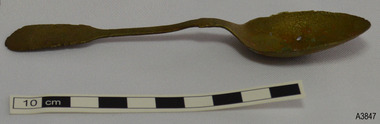 Flagstaff Hill Maritime Museum and Village
Domestic object - Spoon, William Page & Co, Circa 1853-1878
... Cranemore Street, Cattle’s Grove and also at 55 Albion St... Cranemore Street, Cattle’s Grove and also at 55 Albion St ...This spoon, made by William Page & Co., is electroplated nickel-silver and was recovered during the late 1960s to early 1970s from an unnamed shipwreck along the coast of Victoria. The shipwrecks in the area range from around the 1840s to the early 1930s. The spoon is part of the John Chance Collection. This spoon is likely to have been recovered be from the wreck of the Loch Ard (1873-1878) as other cutlery in the Flagstaff Hill’s Shipwreck Collection made by William Page was also recovered from the Loch Ard. The ship’s Manifest included a large quantity of cutlery. Also, other objects in the John Chance Collection were also recovered from wreck of the Loch Ard. In the mid-1800s electroplated cutlery became a popular substitute for the traditional but more costly sterling silver pieces. The ‘new’ cutlery was made from a more common base metal, such as nickel or a nickel alloy, then electroplated (coated) with a very thin layer of silver. The eating utensils looked like the expensive, pure silver version but eventually, through use and wear, the base metal would show. Some producers warranted their electroplated silver to be ‘white throughout’. WILLIAM PAGE & CO., BIRMINGHAM, ENGLAND - Although the electroplated cutlery of William Page & Co. was made in Birmingham, it does not include the embossed Birmingham Assay’s mark of an ‘anchor’ because the metal used for the spoons is not silver. William Page used various Maker’s Marks on his cutlery. The pattern of five embossed marks on this spoon is a typical example, with the embossed sunken crown containing ‘W P’ being the first in the column of symbols. - ‘W P’, within raised diamond outline, within sunken crown - ‘Cross above Triangle’ symbol within sunken oval - ‘Maltese Cross’ symbol within sunken, six-sided shape - ‘crab-like’ symbol within sunken oval - ‘R D’ within sunken diamond William Page established his business in 1834, according to the text around a printed Trademark. The firm William Page & Co. began electroplating in 1855, and from 1880 it operated from Cranemore Street, Cattle’s Grove and also at 55 Albion St, Birmingham. The firm registered a new Trademark [‘W P’ within a diamond boarder within a sunken diamond] in 1897; previously the Mark were the initials WP within a crown, but the British legislation prohibited the use of a ‘crown’ mark on electroplated ware in 1895. In 1936 the firm became William Page & Co. Ltd and became a supplier of spoons to the British Government in 1938, marking its products with the ‘broad arrow’ symbol. The firm also traded with the brand names Armour, Asrista, Bolivian Silver, Roman Silver, Roumanian Silver, Silverite and Trevor Plate. Although this spoon is not linked to a particular shipwreck, it is very likely to have come from the wreck of the Loch Ard; the ship’s Manifest includes a large quantity of cutlery. Regardless, it is recognised as being historically significant as an example of cutlery carried onboard a ship as either personal belongings or cargo and brought into Colonial Victoria in the 19th to early 20th century; through this we have added opportunity to interpret Victoria’s social and historical themes of those times. The spoon also has significance for its connection with many similar William Page pieces of cutlery in our collection that were recovered from the wreck of the sailing ship Loch Ard (1873-1878). William Page & Co. of Birmingham is one of the renowned 19th century manufacturers and electroplaters and was supplier of spoons to the British Government in 1938. The spoon has added significance, as it was recovered by John Chance, a diver of wrecks, including the Loch Ard, in Victoria’s coastal waters in the late 1960s to early 1970s. Items that come from several wrecks have since been donated to the Flagstaff Hill Maritime Village’s museum collection by his family, illustrating this item’s level of historical value.Spoon; teaspoon, electroplate nickel-silver, discoloured to green and red-brown in places. Fiddle design. Bowl has indents and holes. Five embossed Maker’s Marks on back of handle, arranged in a column from tip towards bowl. Made by William Page and Co., Birmingham. The spoon no longer has its silver plating. The surface has encrustations. Bowl has nicks, indents and holes. Stem is very bent at the shoulder. Discoloured to green and red-brown in places. Embossed Maker Marks - ‘W P’, within raised diamond outline, within sunken crown - ‘Cross above Triangle’ symbol within sunken oval - ‘Maltese Cross’ symbol within sunken, six-sided shape - ‘crab-like’ symbol within sunken oval - ‘R D’ within sunken diamondflagstaff hill maritime museum, maritime museum, shipwreck coast, flagstaff hill maritime village, great ocean road, shipwreck artefact, john chance, loch ard, cutlery, flatware, silverware, tableware, eating utensils, dining, spoon, electroplated cutlery, william page & co, william page & co. ltd., birmingham plate, silversmith, antique, vintage, fiddle design, fiddle pattern, teaspoon -
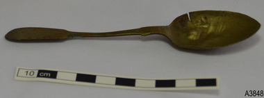 Flagstaff Hill Maritime Museum and Village
Domestic object - Spoon, William Page & Co, Circa 1853-1878
... Cranemore Street, Cattle’s Grove and also at 55 Albion St... Cranemore Street, Cattle’s Grove and also at 55 Albion St ...This spoon, made by William Page & Co., is electroplated nickel-silver and was recovered during the late 1960s to early 1970s from an unnamed shipwreck along the coast of Victoria. The shipwrecks in the area range from around the 1840s to the early 1930s. The spoon is part of the John Chance Collection. This spoon is likely to have been recovered be from the wreck of the Loch Ard (1873-1878) as other cutlery in the Flagstaff Hill’s Shipwreck Collection made by William Page was also recovered from the Loch Ard. The ship’s Manifest included a large quantity of cutlery. Also, other objects in the John Chance Collection were also recovered from wreck of the Loch Ard. In the mid-1800s electroplated cutlery became a popular substitute for the traditional but more costly sterling silver pieces. The ‘new’ cutlery was made from a more common base metal, such as nickel or a nickel alloy, then electroplated (coated) with a very thin layer of silver. The eating utensils looked like the expensive, pure silver version but eventually, through use and wear, the base metal would show. Some producers warranted their electroplated silver to be ‘white throughout’. WILLIAM PAGE & CO., BIRMINGHAM, ENGLAND - Although the electroplated cutlery of William Page & Co. was made in Birmingham, it does not include the embossed Birmingham Assay’s mark of an ‘anchor’ because the metal used for the spoons is not silver. William Page used various Maker’s Marks on his cutlery. The pattern of five embossed marks on this spoon is a typical example, with the embossed sunken crown containing ‘W P’ being the first in the column of symbols. - ‘W P’, within raised diamond outline, within sunken crown - ‘Cross above Triangle’ symbol within sunken oval - ‘Maltese Cross’ symbol within sunken, six-sided shape - ‘crab-like’ symbol within sunken oval - ‘R D’ within sunken diamond William Page established his business in 1834, according to the text around a printed Trademark. The firm William Page & Co. began electroplating in 1855, and from 1880 it operated from Cranemore Street, Cattle’s Grove and also at 55 Albion St, Birmingham. The firm registered a new Trademark [‘W P’ within a diamond boarder within a sunken diamond] in 1897; previously the Mark were the initials WP within a crown, but the British legislation prohibited the use of a ‘crown’ mark on electroplated ware in 1895. In 1936 the firm became William Page & Co. Ltd and became a supplier of spoons to the British Government in 1938, marking its products with the ‘broad arrow’ symbol. The firm also traded with the brand names Armour, Asrista, Bolivian Silver, Roman Silver, Roumanian Silver, Silverite and Trevor Plate. Although this spoon is not linked to a particular shipwreck, it is very likely to have come from the wreck of the Loch Ard; the ship’s Manifest includes a large quantity of cutlery. Regardless, it is recognised as being historically significant as an example of cutlery carried onboard a ship as either personal belongings or cargo and brought into Colonial Victoria in the 19th to early 20th century; through this we have added opportunity to interpret Victoria’s social and historical themes of those times. The spoon also has significance for its connection with many similar William Page pieces of cutlery in our collection that were recovered from the wreck of the sailing ship Loch Ard (1873-1878). William Page & Co. of Birmingham is one of the renowned 19th century manufacturers and electroplaters and was supplier of spoons to the British Government in 1938. The spoon has added significance, as it was recovered by John Chance, a diver of wrecks, including the Loch Ard, in Victoria’s coastal waters in the late 1960s to early 1970s. Items that come from several wrecks have since been donated to the Flagstaff Hill Maritime Village’s museum collection by his family, illustrating this item’s level of historical value.Spoon; teaspoon, electroplate nickel-silver, silver discoloured to brown. Fiddle design. Five embossed Hallmarks. Five embossed Maker’s Marks on back of handle, arranged in a column from tip towards bowl. Made by William Page and Co., Birmingham. The spoon no longer has its silver plating. Bowl has a cut in the side, and is nicked and dented. Embossed Maker Marks - ‘W P’, within raised diamond outline, within sunken crown - ‘Cross above Triangle’ symbol within sunken oval - ‘Maltese Cross’ symbol within sunken, six-sided shape - ‘crab-like’ symbol within sunken oval - ‘R D’ within sunken diamondflagstaff hill maritime museum, maritime museum, shipwreck coast, flagstaff hill maritime village, great ocean road, shipwreck artefact, john chance, loch ard, cutlery, flatware, silverware, tableware, eating utensils, dining, spoon, electroplated cutlery, william page & co, william page & co. ltd., birmingham plate, silversmith, antique, vintage, fiddle design, fiddle pattern, teaspoon -
 Glen Eira Historical Society
Album - Album page, Labassa, 4 Manor Grove, Circa 1972
... Estate, with the formation of Labassa Grove and Ontario Street... Estate, with the formation of Labassa Grove and Ontario Street ...This photograph is part of the Caulfield Historical Album 1972. This album was created in approximately 1972 as part of a project by the Caulfield Historical Society to assist in identifying buildings worthy of preservation. The album is related to a Survey the Caulfield Historical Society developed in collaboration with the National Trust of Australia (Victoria) and Caulfield City Council to identify historic buildings within the City of Caulfield that warranted the protection of a National Trust Classification. Principal photographer thought to be Trevor Hart, member of Caulfield Historical Society. Most photographs were taken between 1966-1972 with a small number of photographs being older and from unknown sources. All photographs are black and white except where stated, with 386 photographs over 198 pages. HISTORY:-- From Victorian Heritage Database citation for Labassa https://vhd.heritagecouncil.vic.gov.au/places/278 as at (26/10/2020) Labassa, Caulfield is one of Melbourne's most lavishly decorated nineteenth century mansions. It resulted from the extensive remodelling in 1890, of an earlier house, known as Sylliott Hill, which was begun in 1862-3 for lawyer, Richard A. Billing. The land at the corner of Balaclava and Orrong Roads was first acquired in 1854 by William Lyall, transferred to his partner, John Mickle, in 1859, who also acquired the adjoining allotment in Balaclava Road, and the three allotments were conveyed to Billing. His first eight-roomed house was extended significantly in 1873 into a twenty-roomed house by architects Crouch and Wilson, who were possibly also responsible for the first house. This reflected Billing's success as a barrister, and he resided at this property until his death in 1882. In 1883 prominent Melbourne businessman, Alexander William Robertson, leased the Sylliott Hill property from Billing's widow, and in 1885 he purchased the adjoining allotment in Balaclava Road. He purchased the Billing's property in 1887 and renamed the 6.31 hectare property, Ontario. In 1889-90, Robertson commissioned the German born architect, John A. B. Koch, to extensively remodel the house into a thirty-five roomed mansion. The existing house was extended and altered, largely resulting in the nineteenth century mansion as it now appears. After Robertson's death in 1896, the house was tenanted until it was eventually sold to the mining millionaire, John Boyd Watson, in 1904. He renamed the property Labassa and carried out repair and re-decoration work to the house. In the early twentieth century, many large estates were subdivided into smaller allotments as the demand for land grew and it became difficult to maintain such large estates. After Watson's death in 1911, portions of the Labassa estate were offered for sale, with Mrs Watson retaining a 1.73 hectare portion containing the house. In 1913 forty-six allotments were auctioned at Labassa Estate, with the formation of Labassa Grove and Ontario Street to the east of the property. Labassa was first recorded as containing flats in 1923 and in the late 1920s, the owner, Robert Hannon, built a red brick block of flats adjacent to the house. Subdivision continued, until the National Trust of Australia (Victoria) purchased the house in 1980 and subsequently purchased adjoining sites, one to the south-east in 1984 (house demolished in 1988) and to the west in 1988. Labassa as it now stands is substantially as it appeared when Koch completed the work in 1890. The original two storey house was transformed into a French Renaissance style mansion, with the addition of a two level L-shaped arcaded verandah and two prominent terminating bays to the south and the east. The building is of unpainted cement render with dressed bluestone plinths, balustraded parapet and steep, slate covered, flat topped mansard roofs behind. A truncated conical roof is a feature of the south bay and a helmeted head is incorporated in the parapet over the east bay. The main south and east facades incorporate many cast cement details, including sculptures, elaborate cornices, swagged Corinthian columns and caryatid consoles flanking the entrance porch, as well as pink marble panels and imitation marble, or scagliola, on curved surfaces. At the rear of the building is a two storey wing and a single storey cottage, the former being connected to the main house by a tower. This section of the house was constructed in 1873. The estate at its peak included stables (1873), conservatory (probably 1890) and a tennis pavilion (probably 1890). All of these outbuildings survive, with the stables and conservatory being converted for residential use after 1922. Internally a range of decorative treatments remain from the late nineteenth century and the early twentieth century, both from the Robertson and Watson periods of occupancy. These include wallpapers, ceiling decoration, chimney pieces, mouldings, joinery and decorative glass. From Victorian Heritage Database citation for H0135 Labassa 2/2A Manor Grove Caulfield North https://vhd.heritagecouncil.vic.gov.au/places/278 as at (26/10/2020) HOW IS IT SIGNIFICANT? Labassa, Caulfield is of architectural, aesthetic and historical significance to the State of Victoria. WHY IS IT SIGNIFICANT? Labassa, Caulfield is of architectural significance as the most prominent example of a small number of houses built in Australia in the French Renaissance style. It is of further note due to the German interpretation of the style and the use of Hellenistic sources, via Germany. It is exceptional for its lavish treatment externally, including marble, scagliola, caryatids, swagged columns, mansard roofs and ornamental cresting. Labassa is of architectural significance as the most important surviving example of German architect, John Koch's domestic work. He undertook a large variety of work in Melbourne, including a number of houses, however Labassa is the most lavish example of his work. Labassa is of aesthetic significance for its outstanding assemblage of late nineteenth and early twentieth century European style interior decoration, which remain remarkably intact. These include a trompe l'oeil ceiling, painted ceilings, embossed imitation leather and other papers, chimney pieces, ceramic tilework, oak parquetry and stained glass, including a tripartite window by Ferguson and Urie, probably dating from the 1873 period. Labassa is of historical significance as an illustrative example of the wealth acquired by a number of prominent Victorian families in the second half of the 19th century. The early development of the property, Sylliott Hill, was due to the wealth acquired by Richard Billing, barrister and fifth Victorian to be appointed Queen's Counsel in 1878. The significant development in 1890 of Ontario, is illustrative of the wealth of Alexander Robertson, a partner in Cobb and Co., a director of Goldsborough Mort & Co., and a pastoral speculator. John B. Watson, whose father had acquired great wealth from the goldfields of Bendigo and subsequently invested in city and country properties, was the third resident to impact on the house, particularly the interiors. The Labassa estate is of historical significance as an illustrative example of the development that occurred in such suburbs as Caulfield in the 1880s due to the land boom, its proximity to Melbourne and the establishment of the Melbourne to Gippsland railway in 1879. It is also illustrative of an estate which succumbed to the pressures of subdividing in the early twentieth century, as properties became difficult to maintain and demand for land close to the city grew. It was typically divided into flats in the 1920s and was used as such for about sixty years. It is of historical significance for its associations with the remnants of the earlier estate which remain extant. These include the stables, conservatory (H2005) and tennis pavilion which all remain on separate sites. Also significant are the remains of early electrical wiring and fittings. Labassa was one of the first houses in Caulfield to be electrified and some of the original wires remain. [Online Data Upgrade Project 2004]Page 128 of Photograph Album with four photographs (two portrait and two landscape) of Labassa.Handwritten: "Labassa" 4 Manor Grove [top right] / Neg 232 8 Oct 1966 [under bottom right photo] / 128 [bottom right]trevor hart, bracketed eaves, slate roof, bay windows, decorative brackets, caulfield north, labassa, richard a. billing, balaclava road, orrong road, sylliott hill, william lyall, crouch and wilson, alexander william robertson, ontario, 1880's, john a. b. koch, mansion, john boyd watson, labassa grove, french renaissance style, l-shaped arcaded verandah, bluestone plinths, balustraded parapet, flat topped mansard roofs, conical roof, elaborate cornices, corinthian columns, caryatid consoles, marble panels, imitation marble, scagliola, tower, conservatory, stables, tennis pavilion, mouldings, decorative glass, caryatids, swagged columns, ornamental cresting, trompe l'oeil ceiling, embossed imitation leather, oak parquetry, stained glass, tripartite window, triple window, ferguson and urie, 1870's, flats, 1920's, electric wiring, 1860's, verandahs, curved windows, arched windows, italianate, terraces, gargoyles, ornamentation, ornate entrance, la bassa, manor grove, st kilda east, victorian, cast iron work, john koch, richard billing, architects, electrification, john mickle, land subdivision, mrs watson, labassa estate, robert hannon, national trust of australia (victoria), sculpture -
 Glen Eira Historical Society
Album - Album page, Labassa, 4 Manor Grove, Circa 1972
... Estate, with the formation of Labassa Grove and Ontario Street... Estate, with the formation of Labassa Grove and Ontario Street ...This photograph is part of the Caulfield Historical Album 1972. This album was created in approximately 1972 as part of a project by the Caulfield Historical Society to assist in identifying buildings worthy of preservation. The album is related to a Survey the Caulfield Historical Society developed in collaboration with the National Trust of Australia (Victoria) and Caulfield City Council to identify historic buildings within the City of Caulfield that warranted the protection of a National Trust Classification. Principal photographer thought to be Trevor Hart, member of Caulfield Historical Society. Most photographs were taken between 1966-1972 with a small number of photographs being older and from unknown sources. All photographs are black and white except where stated, with 386 photographs over 198 pages. HISTORY:-- From Victorian Heritage Database citation for Labassa https://vhd.heritagecouncil.vic.gov.au/places/278 as at (26/10/2020) Labassa, Caulfield is one of Melbourne's most lavishly decorated nineteenth century mansions. It resulted from the extensive remodelling in 1890, of an earlier house, known as Sylliott Hill, which was begun in 1862-3 for lawyer, Richard A. Billing. The land at the corner of Balaclava and Orrong Roads was first acquired in 1854 by William Lyall, transferred to his partner, John Mickle, in 1859, who also acquired the adjoining allotment in Balaclava Road, and the three allotments were conveyed to Billing. His first eight-roomed house was extended significantly in 1873 into a twenty-roomed house by architects Crouch and Wilson, who were possibly also responsible for the first house. This reflected Billing's success as a barrister, and he resided at this property until his death in 1882. In 1883 prominent Melbourne businessman, Alexander William Robertson, leased the Sylliott Hill property from Billing's widow, and in 1885 he purchased the adjoining allotment in Balaclava Road. He purchased the Billing's property in 1887 and renamed the 6.31 hectare property, Ontario. In 1889-90, Robertson commissioned the German born architect, John A. B. Koch, to extensively remodel the house into a thirty-five roomed mansion. The existing house was extended and altered, largely resulting in the nineteenth century mansion as it now appears. After Robertson's death in 1896, the house was tenanted until it was eventually sold to the mining millionaire, John Boyd Watson, in 1904. He renamed the property Labassa and carried out repair and re-decoration work to the house. In the early twentieth century, many large estates were subdivided into smaller allotments as the demand for land grew and it became difficult to maintain such large estates. After Watson's death in 1911, portions of the Labassa estate were offered for sale, with Mrs Watson retaining a 1.73 hectare portion containing the house. In 1913 forty-six allotments were auctioned at Labassa Estate, with the formation of Labassa Grove and Ontario Street to the east of the property. Labassa was first recorded as containing flats in 1923 and in the late 1920s, the owner, Robert Hannon, built a red brick block of flats adjacent to the house. Subdivision continued, until the National Trust of Australia (Victoria) purchased the house in 1980 and subsequently purchased adjoining sites, one to the south-east in 1984 (house demolished in 1988) and to the west in 1988. Labassa as it now stands is substantially as it appeared when Koch completed the work in 1890. The original two storey house was transformed into a French Renaissance style mansion, with the addition of a two level L-shaped arcaded verandah and two prominent terminating bays to the south and the east. The building is of unpainted cement render with dressed bluestone plinths, balustraded parapet and steep, slate covered, flat topped mansard roofs behind. A truncated conical roof is a feature of the south bay and a helmeted head is incorporated in the parapet over the east bay. The main south and east facades incorporate many cast cement details, including sculptures, elaborate cornices, swagged Corinthian columns and caryatid consoles flanking the entrance porch, as well as pink marble panels and imitation marble, or scagliola, on curved surfaces. At the rear of the building is a two storey wing and a single storey cottage, the former being connected to the main house by a tower. This section of the house was constructed in 1873. The estate at its peak included stables (1873), conservatory (probably 1890) and a tennis pavilion (probably 1890). All of these outbuildings survive, with the stables and conservatory being converted for residential use after 1922. Internally a range of decorative treatments remain from the late nineteenth century and the early twentieth century, both from the Robertson and Watson periods of occupancy. These include wallpapers, ceiling decoration, chimney pieces, mouldings, joinery and decorative glass.From Victorian Heritage Database citation for H0135 Labassa 2/2A Manor Grove Caulfield North https://vhd.heritagecouncil.vic.gov.au/places/278 as at (26/10/2020) HOW IS IT SIGNIFICANT? Labassa, Caulfield is of architectural, aesthetic and historical significance to the State of Victoria. WHY IS IT SIGNIFICANT? Labassa, Caulfield is of architectural significance as the most prominent example of a small number of houses built in Australia in the French Renaissance style. It is of further note due to the German interpretation of the style and the use of Hellenistic sources, via Germany. It is exceptional for its lavish treatment externally, including marble, scagliola, caryatids, swagged columns, mansard roofs and ornamental cresting. Labassa is of architectural significance as the most important surviving example of German architect, John Koch's domestic work. He undertook a large variety of work in Melbourne, including a number of houses, however Labassa is the most lavish example of his work. Labassa is of aesthetic significance for its outstanding assemblage of late nineteenth and early twentieth century European style interior decoration, which remain remarkably intact. These include a trompe l'oeil ceiling, painted ceilings, embossed imitation leather and other papers, chimney pieces, ceramic tilework, oak parquetry and stained glass, including a tripartite window by Ferguson and Urie, probably dating from the 1873 period. Labassa is of historical significance as an illustrative example of the wealth acquired by a number of prominent Victorian families in the second half of the 19th century. The early development of the property, Sylliott Hill, was due to the wealth acquired by Richard Billing, barrister and fifth Victorian to be appointed Queen's Counsel in 1878. The significant development in 1890 of Ontario, is illustrative of the wealth of Alexander Robertson, a partner in Cobb and Co., a director of Goldsborough Mort & Co., and a pastoral speculator. John B. Watson, whose father had acquired great wealth from the goldfields of Bendigo and subsequently invested in city and country properties, was the third resident to impact on the house, particularly the interiors. The Labassa estate is of historical significance as an illustrative example of the development that occurred in such suburbs as Caulfield in the 1880s due to the land boom, its proximity to Melbourne and the establishment of the Melbourne to Gippsland railway in 1879. It is also illustrative of an estate which succumbed to the pressures of subdividing in the early twentieth century, as properties became difficult to maintain and demand for land close to the city grew. It was typically divided into flats in the 1920s and was used as such for about sixty years. It is of historical significance for its associations with the remnants of the earlier estate which remain extant. These include the stables, conservatory (H2005) and tennis pavilion which all remain on separate sites. Also significant are the remains of early electrical wiring and fittings. Labassa was one of the first houses in Caulfield to be electrified and some of the original wires remain. [Online Data Upgrade Project 2004]Page 129 of Photograph Album with three landscape photographs of Labassa. One of the photographs is of Labassa's drive and gates.Handwritten: 4 JUNE 1910 / SALE JUNE 28 1910 "LA BASSA' / "AUSTRALASIAN" FORMERLY "ONTARIO"/ RES OF JOHN B WATSON / 15 ACRES 3 ROADS [under bottom left photo] / 4 JUNE 1910 [under bottom right photo] / 129 [bottom left]trevor hart, bracketed eaves, intricate lacework, slate roof, bay windows, decorative brackets, caulfield north, labassa, richard a. billing, balaclava road, orrong road, sylliott hill, william lyall, crouch and wilson, alexander william robertson, ontario, 1880's, john a. b. koch, mansion, john boyd watson, labassa grove, french renaissance style, l-shaped arcaded verandah, bluestone plinths, balustraded parapet, flat topped mansard roofs, conical roof, elaborate cornices, corinthian columns, caryatid consoles, marble panels, imitation marble, scagliola, tower, conservatory, stables, tennis pavilion, mouldings, decorative glass, caryatids, swagged columns, ornamental cresting, trompe l'oeil ceiling, embossed imitation leather, oak parquetry, stained glass, tripartite window, triple window, ferguson and urie, 1870's, flats, 1920's, electric wiring, 1860's, verandahs, curved windows, arched windows, italianate, terraces, gargoyles, ornamentation, ornate entrance, la bassa, manor grove, st kilda east, gates, cast iron work, richard billing, architects, john koch, electrification, victorian style, drives, john mickle, land subdivision, mrs watson, labassa estate, robert hannon, national trust of australia (victoria), sculpture -
 Old Colonists' Association of Ballarat Inc.
Photograph - Image, The History of Charles Anderson and Charles Anderson Grove, Ballarat
... a private road to be named Anderson Grove as Anderson Street already... (North) Street Ballarat Central goldfields Information relating ...Information relating to Charles Anderson and Charles Anderson Grove, Lake Gardens, Ballarat. The Old Colonists' Association Ballarat Inc. is a not for profit charitable organisation providing accommodation for elderly people. It manages a 27 Home retirement village at Charles Anderson Grove, Ballarat. Accommodation is offered at significantly below market rates. It has been providing low cost accommodation to the elderly since the 1920s. The Association Council overseas the running of this facility on a voluntary basis. HISTORY OF THE BALLARAT OLD COLONISTS' ASSOCIATION HOMES AT CHARLES ANDERSON GROVE, LAKE GARDENS One of the original objectives of the Association was “to provide the shelter of a house for those Pioneers of the Goldfields whom the reverses of fortune have deprived of the means of procuring the comforts of life in their declining years.” While the first home at Charles Anderson Grove was built in 1925 the Association had previously provided relief for needy pioneers from the time it was formed in 1883. Relief included monthly monetary payments, loads of firewood, medical assistance and distribution of Christmas boxes of groceries to deserving pensioners and in some cases payment of burial costs. Records indicate that in September 1922 three of the pensioners being assisted by the Association were accepted as residents in the newly erected Hassell Homes in Gillies Street (now demolished-opposite the High School). The first site for an Asylum for Indigent Members of the Old Colonists' Association was temporarily reserved from sale in October 1891. The site was approximately 28 acres in area in Mt Clear nearly opposite Midvale Shopping Centre in Main Road. The site was heavily timbered and when cleared over 260 tons of wood was sold to the Woah Hawp Gold Mining Company. A set of gates were erected but no homes built, although a plan for this reserve was drawn which showed twenty buildings ranging from one to four unit per building. The reserve was revoked in November 1909. The second site temporarily reserved in November 1909 as an Asylum was in Alfredton and consisted of some 7 acres and was adjacent to land reserved for an Abattoirs for the Ballarat Council. The reserve was revoked in February 1912 as it was deemed more appropriate to be added to the Abattoir site. Council suggested four (4) other sites in exchange for this land and they were inspected by the President, Vice President and Secretary on 22 December 1912. The first site inspected was land on the west side of Creswick Road opposite the brick kilns (now occupied by the showgrounds and oval). The land was described as being good quality, well fenced, no trees, good drainage and ample acreage but some distance from trams. The second site was Perry Park which was described as being good land, well fenced, having frontage to Gillies Street, good drainage and about 26 acres (but subsequently reduced to 10 acres). It was closely planted with Pinus Insignias and Wattle and had easy access from the Botanic Gardens tram. The third site was the North West portion of Victoria Park (corner of Sturt and Gillies Street) and was described as good land, well fenced and drained and well located. The fourth site was the South West corner of Victoria Park and known as Pound Paddock (corner of Winter Street and Gillies Street). It was considered to be low lying and too close to the Abattoir, and was also a considerable distance from trams. While the third site was recommended as the most suitable for the erection of homes it was considered unwise from the point of view as citizens to reduce the acreage of the park and therefore it was recommended that the Perry Park site be asked for as the most acceptable to the Association for the building of homes. The site was eventually temporarily reserved for an Asylum for Indigent Members of the Association in April 1914 with the gates from Mt Clear having been removed to the site a year earlier and eventually erected in 1917 for £12.10.0. In the same year the first 290 pine trees were advertised for removal in July and sold for £16. A sign indicating that the site was reserved for the erection of cottages was erected in September 1917. Stripping of the wattle bark (for tanning) and the cutting of the wood occurred in November 1918 with the land then being leased until it was required for the construction of the first homes in 1924. While the site was the third to be reserved it was the only one which was used for its intended purpose. It was named as Charles Anderson Grove in honour of Charles Anderson who joined the Association in 1918 and was President of the Association from 1942 to 1944. CHARLES HENRY GRATTAN ANDERSON C.H.G. Anderson (Electoral Returning Officer) was elected to membership of the Old Colonists' Association, Ballarat, in October 1918. He was elected to the Association Committee in 1926, and appointed Treasurer of the Association on the resignation of F. Ellis until the end of the financial year in 1933. In 1936 Charles Anderson indicated he would not be available for the President's Chair and that he would retire from the Committee owing to pressure of work. C.H.G. Anderson was welcomed as a new member of the Association in 1938, and served as President of the Old Colonists' Association from 1942-1944. Midway through 1949 Charles Anderson was appointed Members Secretary and Manager of the Ballarat Old Colonists' Club at £5.0.0 per week and 10/- for entertainment, to commence work prior to 01 August 1949. He was to do 30 hours per week and be present on Friday and generally on Saturday nights. In 1957 a minute of sympathy was extended to Club Manager Charles Anderson on the loss of his son. In 1958 a bonus of £20.0.0 was paid to Charles Anderson in recognition of his service in assisting the Secretary/Manager taking over under difficult conditions. In March 1964 the Shire of Ballarat would not permit a private road to be named Anderson Grove as Anderson Street already existed in Ballarat but Charles Anderson Grove was deemed acceptable. A recommendation of the Committee was put to the AGM in 1967 that Charles Anderson be made a Life Member. In 1969 an Association meeting observed a minutes silence in memory of Chas Anderson. Charles Anderson was also a Committee member of Ballarat Mechanics' Institute from February 1940 to February 1970. He was President in 1948. Black and white photographic portrait of Charles Anderson.charles anderson, charles anderson grove, ballarat old colonists' club, old colonists' association, ballarat, ballarat mechanics' institute, hassell homes, woah hawp gold mining company, firewood, retirement village -
 The Beechworth Burke Museum
Audio - Oral History, Jennifer Williams, Mr Albert (Bert) Nankervis, 15th March 2000
Mr Albert (Bert) Nankervis was born at Thougla, in the Upper Murray, in 1903. He had a large family and was one of eight children, four boys and four girls. He and his family moved to a farm in Wooragee named ‘Wattle Grove’ in 1918 after his father returned from serving as a soldier in World War One. The family established ‘Wattle Grove’ as a dairy farm as Beechworth has a high demand for milk and little supply. They had 25 milk cows that were hand milked every morning in order to provide milk for approximately 100 customers in the town, with any extra going to the butter factory at Springhurst. Albert married Floré Lilias Hardy in 1930 and they had two sons, Phillip and Barry. In this oral history, Albert discusses his life as a farmer in Wooragee, including his role in getting electricity to Beechworth, as well as his participation in the Young Farmer’s Association Immigration Scheme, which provided work experience to migrants in order for them to learn how to farm. This oral history recording was part of a project conducted by Jennifer Williams in the year 2000 to capture the everyday life and struggles in Beechworth during the twentieth century. This project involved recording seventy oral histories on cassette tapes of local Beechworth residents which were then published in a book titled: Listen to what they say: voices of twentieth century Beechworth. These cassette tapes were digitised in July 2021 with funds made available by the Friends of the Burke. Mr Albert (Bert) Nankervis’s account of his life in Wooragee and the local area, including Beechworth, during the early 20th century is historically and socially significant to the cultural heritage of the region. He details his life as a farmer and milkman in the early 20th century, particularly the interwar period (1918-1939), but also discusses life after the Second World War, including employing young migrant men to train them as farmers through the Young Farmer’s Association. This oral history account is socially and historically significant as it is a part of a broader collection of interviews conducted by Jennifer Williams which were published in the book 'Listen to what they say: voices of twentieth-century Beechworth.' While the township of Beechworth is known for its history as a gold rush town, these accounts provide a unique insight into the day-to-day life of the town's residents during the 20th century, many of which will have now been lost if they had not been preserved. This is a digital copy of a recording that was originally captured on a cassette tape. The cassette tape is black with a horizontal white strip and is currently stored in a clear flat plastic rectangular container. It holds up 45 minutes of recordings on each side.Mr Albert (Bert) Nankervis / albert nankervis, bert nankervis, nankervis, wattle grove, wooragee, dairy farm beechworth, dairy farm, dairy factories beechworth, dairying, milkman, oral history, springhurst, butter factory, electricity, rural life, farming and agriculture, farm, farm work, cow, cattle, jersey cattle, interwar period, first world war, second world war, wwi, wwii, greatest generation, centenarian, nonagenarian, 1920s, 1930s beechworth, thougla, upper murray, murray, lucyvale, benalla -
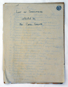 Orbost & District Historical Society
document, Grove, Carl, June 18 1910
Charles Henry [Carl] Grove died on 17/4/1938 at Box Hill at the age of 88 and was buried in Orbost. Prior to coming to the Snowy River district, Carl worked as overseer on Buchan Station. In 1880, he selected land at Newmerella after first coming here in 1874 with early selector James A Robertson. He married Annie Robertson in 1876. Carl was a farmer, hop and seed grower and nurseryman. He was an elected Councillor of the newly formed Tambo Shire in 1882, and then in 1892 to the Orbost Shire where he served for many years filling varioius public roles. In 1911, he shifted to Queensland, but later returned to Victoria and died at Box Hill. (Ref. Nov 2014 Newsletter) Carl Grove was a prominent Orbost early settler. This document is a useful research tool.A document hand-written on foolscap sized paper. There is a "List of Species Collected by Mr Carl Grove" and a letter written by Carl Grove to the president and committee of the Mechanics Institute Orbost.document-species-list-orbost grove-carl -
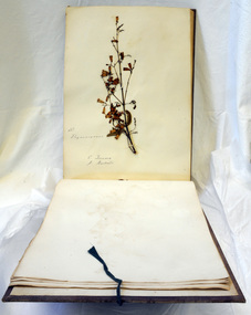 Orbost & District Historical Society
books, 1890's
These albums are attributed to Carl Grove (1849-1939) , first selector at Newmerella, where he planted hops in the 1880's. He was an orbost Shire councillor for 25 years, helped to establish the library and the Mechanics Institute and was one of the first Orbost Butter Factory directors.These albums are significant mainly for their connection to Carl Grove.The collection of live plant specimens from the wild with correct labelling can provide a record to be used for research.Three large books of botanical specimens. Each has a brown cloth cover which has cloth tape ties attached.On front cover - FRONTgrove-carl album plants botany -
 Orbost & District Historical Society
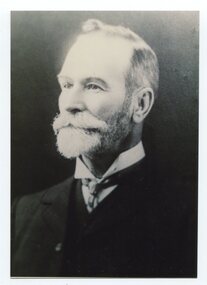
black and white photograph, late 19th / early 20th century
This is a photograph of Councillor Charles Henry Grove who represented South Riding on the Orbost Shire Council. from 1893 - 1901. He was president in 1893-1894, 1895-1896 and 1900-1901. He also served on the Tambo Shire prior to the formation of the Croajingolong / Orbost Shire. Charles Henry [Carl] Grove died on 17/4/1938 at Box Hill at the age of 88 and was buried in Orbost. Prior to coming to the Snowy River district, Carl worked as overseer on Buchan Station. In 1880, he selected land at Newmerella after first coming here in 1874 with early selector James A Robertson. He married Annie Robertson in 1876. Carl was a farmer, hop and seed grower and nurseryman. He was an elected Councillor of the newly formed Tambo Shire in 1882, and then in 1892 to the Orbost Shire where he served for many years filling various public roles. In 1911, he shifted to Queensland, but later returned to Victoria and died at Box Hill. (info. Newsletter 113)This item is associated with the Orbost Shire Council. The shire covered an area of 9,347 square kilometres and existed from 1892 until 1994 when it became part of the East Gippsland Shire Council. It is associated with Carl Grove, a prominent early Orbost citizen.A black / white head and shoulders portrait photograph of a bearded man in a suit. There is also a framed copy.grove-charles-henry grove-carl orbost-shire-council -
 Orbost & District Historical Society
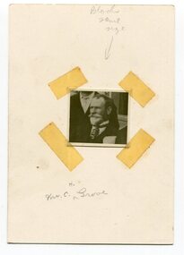
black and white photograph, early 20th century
This is a photograph of Councillor Charles Henry Grove who represented South Riding on the Orbost Shire Council. from 1893 - 1901. He was president in 1893-1894, 1895-1896 and 1900-1901. He also served on the Tambo Shire prior to the formation of the Croajingolong / Orbost Shire. Charles Henry [Carl] Grove died on 17/4/1938 at Box Hill at the age of 88 and was buried in Orbost. Prior to coming to the Snowy River district, Carl worked as overseer on Buchan Station. In 1880, he selected land at Newmerella after first coming here in 1874 with early selector James A Robertson. He married Annie Robertson in 1876. Carl was a farmer, hop and seed grower and nurseryman. He was an elected Councillor of the newly formed Tambo Shire in 1882, and then in 1892 to the Orbost Shire where he served for many years filling various public roles. In 1911, he shifted to Queensland, but later returned to Victoria and died at Box Hill. (info. Newsletter 113Carl Grove was a prominent early Orbost citizen.A small square head and shoulders photograph of a man. It is attached to a white card with tape.on front - "Mr C. Grove"grove-charles